
New iThing charting apps, EarthNC & eSeaChart
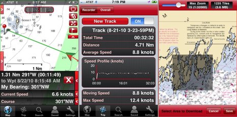
Not one but two iPhone NOAA raster charting apps debuted last week, and I had had a little Beta time with each. EarthNC for iPhone costs $25 and incorporates some fresh thinking and a lot of the resources EarthNC has long been developing for its Google Map & Earth overlay products, like EarthNC Online. They’ve turned all NOAA RNCs into tiles that download automatically to your phone as you pan and zoom, or you can batch download an area as illustrated in the screen at upper right. The left screen is busy looking, I know, but note how you can disappear each of those data and icon strips with the little red arrow. Note too how EarthNC is doing waypoint navigation and tracking, fairly elaborate tracking as shown on the middle screen. But that’s not all…
What really distinguishes EarthNC is a wealth of overlay and reference data. Check the screen series below to see how you can easily look up local NOAA weather buoy reports and text forecasts. You can also get tide tables, though text only so far, and a POI list EarthNC has distilled from the ENC vector charts, like significant nav aids (which can also be overlaid). The latter seems a little thin so far, but you can use them as go-to waypoints, bookmark them, email them, even jump over to Google Maps for driving/walking directions to them, as you can all this geo-located info. Finally, you get a choice (under the wrench button) of searching Marina Life, Cruisersnet, or Waterway Guide marina, anchorage, etc. information. What you get is usually just an address, maybe a phone #, but also a link to more info at the guide’s site. None of the sources are very good for Maine right now, but are probably more complete further down the coast, and what other charting app offers them? (Well, Navimatics Charts & Tides does have ActiveCaptain data, and you don’t need a cell connection to access it, which is darn cool.)
I’ve run into a few bugs in EarthNC, but it’s a whole lot of app for a 1.0 release, and there’s no question that the company is serious and ambitious about mobile charting. In fact, there’s already an EarthNC iPad version, same price, and an Android version in Beta (which I’m trying). I hope to meet with one of the principals later this week and will add what I learn to the comments section…
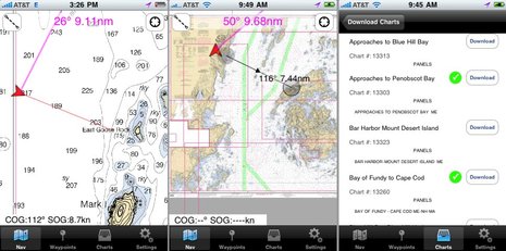
 Meanwhile, eSeaChart — which costs $10, no iPad version yet — takes a much simpler approach. You download NOAA RNC raster charts direct from NOAA and can only use one at a time, and so far it only supports go-to-waypoint navigation and distance/course measurements. But the developers have focused on a clear, quick chart presentation — which shows (screens below) — and are already working on batch downloads, seamless charting, etc. eSeaChart will particularly appeal to traditional paper chart users, I think, but already has lots of competition in that department, like Memory Map — still the king of fast and legible rasters, I think — and of course iNavX, still the most complete navigation app out there (I think).
For some reason Navionics hasn’t yet released its new chart downloading app, but I can tell you that it just gets better and better in Beta, as does the original app, which is now up to V4.4. Personally, I love how well Google satellite land photos integrate with sharp Navionics marine charts in both versions. Oh, and I just learned that yet another player has entered this busy niche. GeoGarage now offers raster charting iPhone and iPad apps for the U.S., New Zealand, and Brazil. And there are several other marine-related iThing programs I plan to write about soon, and Droid stuff.


PS. I have a few eSeaChart redemption codes to give away to folks willing to give it a try and comment about the app here. You need either an iPhone or an iPad with GPS. Email “[email protected]”; first come, first served.
Correction: eSeaChart only runs on OS4, so there’s no iPad support at all yet.
Also, I now have some redemption codes for Memory Map PocketNav to give away too. Runs on iPhones and iPads. You can try both if you email me quick enough…
{sorry, all codes have been given out}
Phillipe Kahn’s MotionX product called simply MotionX GPS is also now offering NOAA charts.
Russ, only MotionX HD for the iPad, I think, and they’re still “experimental”. I got the impression that the NOAA map files were very large and slow to start, but no doubt Fullpower will get it right eventually. Plus the app is only $3, and the iPhone version without charts is excellent.
Ben – The iPhone version offers “NOAA experimental” charts for download. I attempted to download the charts for San Francisco, a total of 92MB, but after 8 hours on a fast connection, it had only downloaded 9% of the charts.
Their topo and road maps were both very slow to download early on. They’re still slow, but you can eventually download the selected area. They are either using a really poor algorithm for downloading tiles, or they scrimped on bandwidth.
In any case, NOAA on MotionX GPS is not ready for prime time.
Hi Ben
Good stuff… any idea when it might be available for Android?
Jim, I talked with the developers on Friday and they are working on the Andriod version as we speak. No word on when it will be available but it should be soon.
Chuck Baier
Waterway Guide
Ben, we are very happy to have Waterway Guide data embedded in the new EarthNC app, along with their other partners. As you know if you have played with it, it will link to our extensive database for bridge tables, anchorages and marina database. The marina database has a lot of details on over 3,000 marinas along the east coast waterways. And that is just for Waterway Guide data. The developers tell us they have lots more improvements and additions coming.
Chuck Baier
Waterway Guide
Ben,
Just to clarify, the EarthNC Marine Charts app is a ‘Universal’ app so it’s the same app on iPhone or iPad but on iPad it automatically changes resolution, menus, etc to leverage the large screen.
We’re hoping to release the Android version later this week – it won’t have all the features as the i-Version in the 1st release and will be priced accordingly – but we will be working to bring it up to feature parity as quickly as we can.
As you mentioned, the Marine service information is just a start – we will be working to a add a lot more to this along with our data partners.
– Virgil
EarthNC
If you’re not interested in the reference materials associated with the EarthNC app, you can get all the benefits of their raster charts via an in-app purchase on Gaia GPS, at less cost. Gaia GPS is a simple, yet functional, universal GPS app for the iPhone and iPad, available for $9. In-app purchases of the EarthNC charts are $5 per region, and reside on the iPhone/iPad. Clearly there is a partnership between these two companies as the user interface in their apps is very similar. Gaia GPS is also available on the Android platform, but I do not know if it offers the option of the EarthNC charts.
> Clearly there is a partnership between these
> two companies…
Gaia GPS wrote the entire application. It’s called “white labeling” and it’s quite common. EarthNC created the chart data and works with the various guidebook content creators to create their POI’s.
I am so happy to see the EarthNC app. I have it and have been using it for a few days now. Congratulations on a fine application and on the v1.0 release.
I am one of the developers of Gaia GPS, and as noted above, we did the iPhone/iPad/Android development for the EarthNC Marine Charts app. For those interested in some back story for EarthNC and Gaia GPS, check out this recent Forbes article: http://www.forbes.com/2010/07/14/navigation-gps-apple-technology-ipad_print.html.
Regarding using Gaia GPS with EarthNC Charts added on – versus using the dedicated Marine Charts app from EarthNC – I think for people primarily interested in boating, the EarthNC app is superior. Even on price, the four regional NOAA sections in Gaia GPS are $4.99 per year, per region, so with the base app cost of $8.99, there aren’t really much savings to be had.
More importantly, lots of useful nautical-related functionality in EarthNC that isn’t in Gaia:
* data feeds from CruisersNet.net, Waterway Guide, and Marinalife (and more coming)
* the “categorical search” interface, for tides, weather, POIs, etc.
* a Google satellite view
* offline caching of POI/tide/weather data
* custom nautical iconography
We’re all very excited about v1.0! EarthNC and the 90 or so beta testers they assembled knew what the app needed to do, and I think that’s the reason the release has been well-received.
We’re now working on v1.1, and we’d definitely appreciate any bug reports. Drop us an email at [email protected] if you find something we should fix. That email address leads to the EarthNC principals – Virgil and Brad – as well as the three of the Gaia GPS developers – Anna, Tim, and myself.
Thanks to Ben, yesterday I was able to add eSeaChart and Memory Map’s Pocket Nav.
I am somewhat a gadget freak. I currently have a 32G iPhone 3Gs running OS 4.2 and a 64G iPad, wifi / 3G with the latest software. I have the following apps: Navionics, iNavx, Charts and Tides, Memory Maps Pocket Nav, eSeaChart, WaterMap, GPS MotionX and Aye Tides.
First the hardware. I was thrilled with the iPhone and will be upgrading to the new iPhone next month for the better display, faster processor and larger battery. The iPad though is my favorite. With both sitting side by side I will always reach for the pad. With the release next month of OS4 for the pad they will be back on level ground regarding which apps can be used on each device.
Now the good the bad and the ugly of apps. Bad and ugly WaterMAP. Don’t waste your money. Navionics, probably a good app but I’m an old paper chart kind of guy.
Downloading maps iNavX and eSeaChart take the lead in ease of use. INavX as I remember was the easiest. eSeaChart you select a state and then download one chart at a time from a list. Pocket Nav requires panning to the end of the currently viewed chart and then downloading the next chart. Once downloaded all three maintain the charts in memory but it does take longer to get up and running with some.
Because eSeaChart requires the OS4 I only have it on the phone and not the pad. For that reason alone I haven’t had much face time with it. It has just been easier over the last 24 hours to put more test time into Pocket Nav.
INavX up until today was my all time favorite but it is lacking something that PocketNav does have and that is the ability to lock the screen in it’s current orientation (for the iPad). OS4 for the pad should fix this for all apps as it is a part of the OS4 system on the phone. So for overall charting use Memory Map Pocket Nav is currently my pick of those apps I have
I don’t have a copy of EarthNC so I can’t comment on it except to say it looks like they may pull together the best from all the apps.
This is just my initial observation. I will update as I get more usage.
Great idea about the screen orientation lock in the app even though the iPad has a physical orientation lock button on it’s side and as you note iOS 4 has the lock button in it’s task bar. iOS 4 will be on iPad very soon which will be a great enhancement allowing one to run several marine apps and quickly switch between them. iOS 3.2 on iPad seems archaic after using iOS 4 on iPhone 4.
Thanks, Anon. Let’s note that Memory Map has a neat feature whereby you can download charts and maps, and GPX files, you’re already using with its PC app via WiFi. I like that it handles seamless 1:24,000 topo maps, too, though you have to buy them.
It’s a bit of an Easter Egg, but if you go into ‘Settings’ – ‘Map Type’ on the EarthNC app, you can select MyTopo which provides seamless Topo Maps for the entire US which is great for the uncharted inland lakes and rivers.
Sorry about the anon on the review but I was having trouble getting logged in.
“…..even though the iPad has a physical orientation lock button on it’s side”
I guess I had a “duh” senior moment. I’ve had the pad from day one and knew about the switch before I forgot bout the switch….Come to think of it instead of a senior moment that could be a politico moment. 😉
Hi JR,
Thanks for trying out eSeaChart. Already implemented in “beta” is a feature which will let you download all charts for an area with a single tap, I know this is a much requested feature. I’m also hard at work making the switching between charts much easier, I still have a lot to do to make it painless but the initial results are very promising. I love getting feedback so please email any thoughts or suggestions to [email protected]!
I have been using the Navionics and Motion-X apps in my iPad for a few weeks now. Thanks to Ben I have now also used PocketNav for a couple of days.
Navionics is clearly impressive- easy to use, routing is intuitive and quick. Motion-X has some neat features on the GPS side, including very large and visible navigation data, but the “experimental” NOAA charts are all but useless. There is very little level of detail and markers and buoys are not there for the most part.
PocketNav is neat. I like having the raster NOAA charts easily accessible, but had trouble creating a route (not very intuitive), deletes waypoints if you remove from a route and the transfer between charts is not as smooth as it could be.
I am hoping that the eSeaChart will be availble for the iPad soon. Looks really interesting.
Hey, kids, now I’ve got some redeem codes for EarthNC, which works on any iThing running 0S3 or OS4. First come, first served, feedback on the app expected; write iphone at panbo.com.
I uploaded the app’s & am trying to learn to use them. The eSeachart seems to be avery good app.
When I learn more I might be able tomake better judgements.
Regards…Harv
I spent much of today preparing for hurricane Earl, and am aboard Gizmo now, though it’s looking now like E. won’t show us much intensity. I’ve found an Android app called Bluefin Marine Weather very useful for watching the NOAA marine forecasts and buoy realities. Anyone else have favorite hurricane phone apps?
Here’s my quick review of MemoryMap as compared to iNavx and also the Garmin 740. For some additional background, my primary use is on a 1984 Sabre 34-I. The iPad apps are used for planning and track logging, but not for actual navigations while underway since the open cockpit is still not a great place for the iPad (weather and sun). However, my radar is still a standalone unit – upgrade to a networked one is on the 2011 plan, so I can see using the iPad as a plotter while the navigator is below watching that display.
I upgraded the older Simrad plotter this year to the Garmin 740 and have been very pleased with the new unit so far. It’s very easy to configure and edit routes, the response time is great and the screen readability is very good, even with polarized glasses. The only thing that I’m not a huge fan of is the amount of screen space taken up by the route display boxes while navigating.
MemoryMap was a bit tricky to get started with, with the caveat that I didn’t read any instructions whatsoever. Eventually, I was able to get maps for most of the Maine coast loaded and everything seemed to look good.
Notes:
* MM seems to load a bit quicker than iNavX.
* MM doesn’t support the pinch-to-zoom functionality very well, there are +/- buttons needed to zoom.
* MM’s “you are here” icon is much easier to see than iNavX’s.
* MM’s track was not accurate for me – although it may have just been the time intervals between when it recorded its waypoints. The iNavX track for the same route was spot-on though.
* Creating routes in MM is a piece of cake once I figured it out (create destination waypoint, then create route back to your starting point, or vice-versa)
* Creating routes in iNavX is different than in MM and on the Garmin, and therefore seems less intuitive. iNavX does allow you to follow the route unlike MM though.
I used the EarthNC on the iPad over the long weekend and was quite frankly very impressed! Their seamless display of the raster charts is very well implemented. When they say seamless, they mean seamless. It feels like a single vector chart. The MemoryMap, on the contrary is somewhat jerky in transferring between raster charts and sometimes even turns them around, which can be disconcerting.
Back to EarthNC, it has loads of information and can be very handy if you are a coastal cruiser. I can see how this app could easily become your main source of marine information. Well done!
I agree with other comments that the iPad is not ready to be your main navigation screen, but it is a nice addition, together with these marine apps, to any boater’s arsenal.
MacENC and GPSNavX running on a recent-vintage Mini built into the helm, doing the WiFi mind-meld with iNavX on an iPad sitting in the helm chair is just insanely cool. My Northstart 6100s are Navionics Vector and we use the Mini for Raster comparison, with the iPad providing for big blow-up of the Raster and very fast looking around. flicking on the iPad is soooo much easier than mousifying.
-mo
I received the download codes for PocketNav and eSeaChart. I already own Navionics and MotionX. I run all this on an iPhone 4.
I’m trying to understand the target customer for these new applications. I carry the iPhone on my sailboat which already has a Raytheon MFD. I also carry it in my dinghy and on kayak trips. My old iPhone 3 was destroyed by “salt air” according to the place that tried to repair it. Thus I’m a little reluctant to pull out the new device.
I don’t yet see a place for these new applications in my world. On the sailboat I mostly use the iPhone for weather and tides/currents. I can see myself also using it for Active Captain data once I find an easy way to access that.
I’ve never used phone applications from the dinghy but feel a little better knowing that I have a chart in hand if I need one. Here the fact Navionics does not download charts is a benefit as cell coverage in Maine is spotty.
When I kayak I like the fact that I can email MotionX tracks to myself and plot them on Google Maps. It gives me a history of my exercise runs. The new map download feature in MotionX is harder to use than the downloads in the new apps. However, MotionX is a better generic GPS app.
It also looks like both new apps use only the raster charts. My area is completely covered by ENC charts. I suspect the vector charts are more up-to-date. Is this suspicion true?
One of the best uses for these iOS charting products for me is as a route planning tool and also to use as a simple plotter in the Nav station.
My boat’s radar is at the Nav station down below, and while using the radar, it’s really helpful to have a live chart reference along with the radar info.
Granted, it would be nice to have the radar display on the MFD, but the radar works perfectly fine and the upgrade isn’t planned for a while.
Using these devices for planning has tremendous potential, I think, especially when they’re online so you can access weather, POI info, etc. right in the app. And very especially when a forward looking MFD manufacturer, or several, make it very easy to pass the route into your primary navigation device (at least one is experimenting).
iPhones, iPads, Droids, etc. can also be great for recording voyages and easily sending tracks, geo positioned photos, etc. to friends and family or to your own blog. I don’t picture using one as a primary nav screen myself, but it is possible, and will be even more possible when someone comes up with an easy, efficient way to get at least NMEA 2000 data to the devices, preferably without wires.
PS I just loaded a beta of yet another new iThing charting app yesterday!
I used EarthNC on my iPhone 3GS a couple of weeks ago for a 75 mile sailboat race here on Lake Champlain. It proved to be very useful 13 hours into the race when our house batteries were discharging at a faster rate than anticipated.
Before the race I had downloaded all of the necessary charts while I had a fast internet connection, and they worked beautifully out on the lake. Nice detail, and much faster redraw time than my Garmin GPSMap 76 that is my traditional backup.
I didn’t check too often, but my only complaint would be that the GPS speed as reported by EarthNC often seemed very low. Not sure what was going on there, and I wasn’t using it for that type of info, but I thought I should note it.
Overall my impression was very good.
Noah
EarthNC is now available in Android Market, for $10, but I don’t think it includes the POI, text weather, and buoy reports, yet. Also MO emailed in this glowing report on the iPad version:
“VERY nice interface! The way the objects get overlaid on the raster is just brilliant. Others have done this (or tried) but this is hyper-slick
What’s missing, though, is integration via wifi with inboard gps and instrument data streams.
I would say, though, that the gauntlet has been thrown down and MacENC and iNav have got a real challenger to the throne.
Everything will get massively better because of it, too, except for the captive software embedded in MFD plotters.
I think this raises some real questions about where innovation will be coming from in the future, or at least how these great ideas are going to get assimilated.
One possible path is that all the sensors, processing, and actuators go “headless” or “black box” and the UI components become independent.
Yes, furuno and gamin and raymarine will have their own slick UIs, but it is in the best interests of any supplier to have their sensors, processing,
and actuators easily usable by anyone.
The next great UI – how about a 3D fish finder with barometric data fused with 3D underwater live
Thermal video? – can come from anywhere and they should want to make it easy to build such things with their kit.”
Ben,
You’re correct, the Android version doesn’t support POIs & weather ‘yet’ – but that is already in the works and it’s our goal to have ‘feature’ parity between Apple and Google versions as fast as we can. It does support user-generated waypoints and ‘guiding’ like the i-App.
Look for version 1.1 of our i-App soon. It adds a ‘track up’ mapping option that many have requested.
On the POI side, Cruisersnet.net now features fuel pricing in many of their marina listings and Marinalife’s listings will be getting an upgrade with photos, slip maps, services, etc… in the next day our two. Users will see these automatically.
Our tide layer now includes all of NOAA’s ‘realtime’ tide stations from their ODIN system. Just look for stations with (NOAA) in their name. These station predictions are updated in realtime with waterlevel data and also include a graphic plot of the predicted vs actual.
– Virgil
EarthNC
Neat. Marina Life is offering a custom version of EarthNC free for 30 days, along with a half price upgrade to the full program. It seems to have more of Marina Life’s marina information built in, too. Just search for Marina Life in the iTunes store.