
New C-MAP Reveal Charts Offer the Clearest View of Structure, Wrecks, Reefs and Ledges
First Three of 11 Charts Released, Now Available for $299 Each
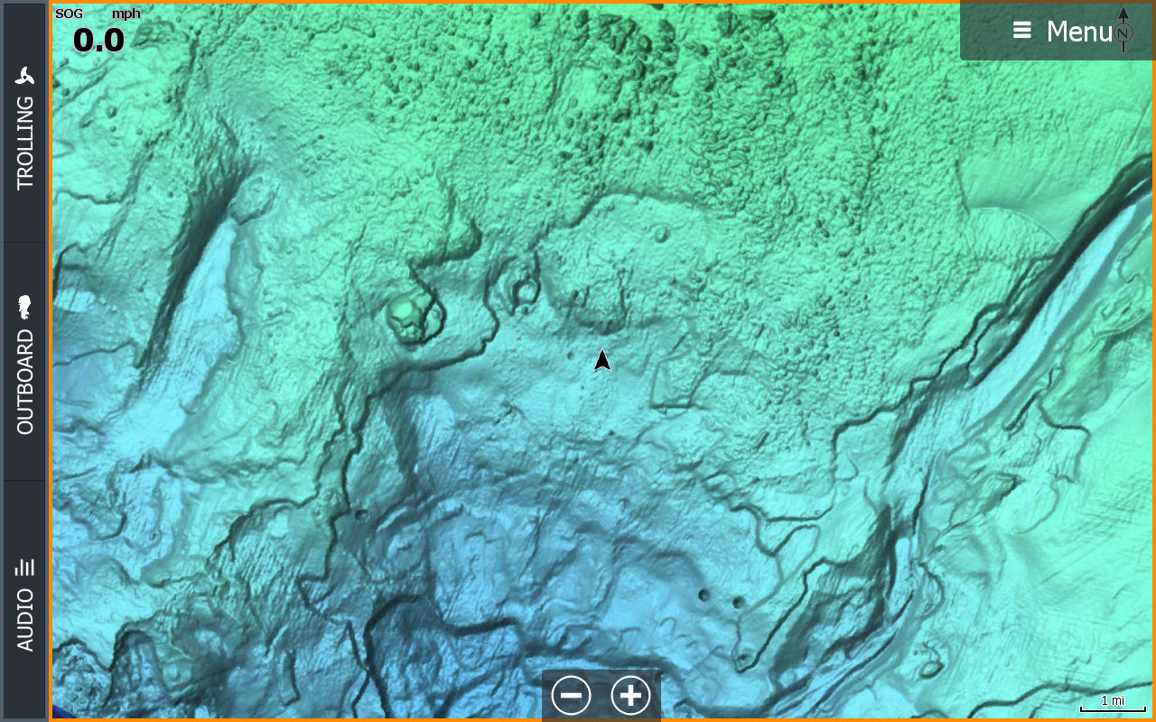
Tulsa, OK – C-MAP, a leader in digital marine cartography and cloud-based mapping, announced today the release of new C-MAP Reveal charts, featuring incredible views of the sea floor – a key advantage for fishing and diving enthusiasts. This new cartography offers all the navigation data and capabilities of a C-MAP MAX-N+ card – plus ultra high-resolution bathymetric imagery of select coastal and offshore areas, including the clearest views of structure, wrecks, isolated reefs and ledges between the contour lines.
The highly detailed C-MAP Reveal imagery replaces shaded relief data in selected areas with more accurate depth variations, allowing it to reveal the best fishing and diving spots. Complete with vector data, these detailed charts include C-MAP HRB Coastal Data, Genesis layer social map data and satellite imagery that can be overlaid directly onto the charts. C-MAP Reveal is available for use on Lowrance, Simrad or B&G chartplotters, excluding Lowrance HOOK2 and Simrad Cruise.
“With the release of C-MAP Reveal, boaters and anglers now have access to the very best charts available for planning and navigating to the most productive fishing spots and the most interesting dive sites,” said Leif Ottosson, CEO, Navico.
Priced at $299 US, 11 new C-MAP Reveal charts will feature the following coverage areas, with the first three SKUs covering Florida and the Gulf Coast area available in April:
| M-NA-Y643 | C–MAP REVEAL: FLORIDA AND THE BAHAMAS (Available in April 2019) |
| M-NA-Y644 | C–MAP REVEAL: ST. LUCIE INLET TO NEW ORLEANS (Available in April 2019) |
| M-NA-Y645 | C–MAP REVEAL: NEW ORLEANS TO BROWNSVILLE (Available in April 2019) |
| M-NA-Y639 | C–MAP REVEAL: PASSAMAQUODDY BAY TO BLOCK ISLAND (Available in June 2019) |
| M-NA-Y640 | C–MAP REVEAL: CAPE COD,LONG IS, HUDSON RIVER (Available in June 2019) |
| M-NA-Y641 | C–MAP REVEAL: BLOCK ISLAND TO NORFOLK (Available in June 2019) |
| M-NA-Y642 | C–MAP REVEAL: NORFOLK TO JACKSONVILLE (Available in June 2019) |
| M-NA-Y652 | C–MAP REVEAL: SAN DIEGO TO SANTA CRUZ (Available in June 2019) |
| M- NA-Y653 | C–MAP REVEAL: POINT SUR TO CAPE BLANCO (Available in June 2019) |
| M-NA-Y654 | C–MAP REVEAL: CAPE BLANCO TO CAPE FLATTERY (Available in June 2019) |
| M-NA-Y659 | C–MAP REVEAL: DIXON ENTRANCE TO CAPE S.ELIAS (Available in June 2019) |
For more information please visit www.c–map.com.
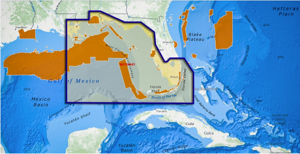
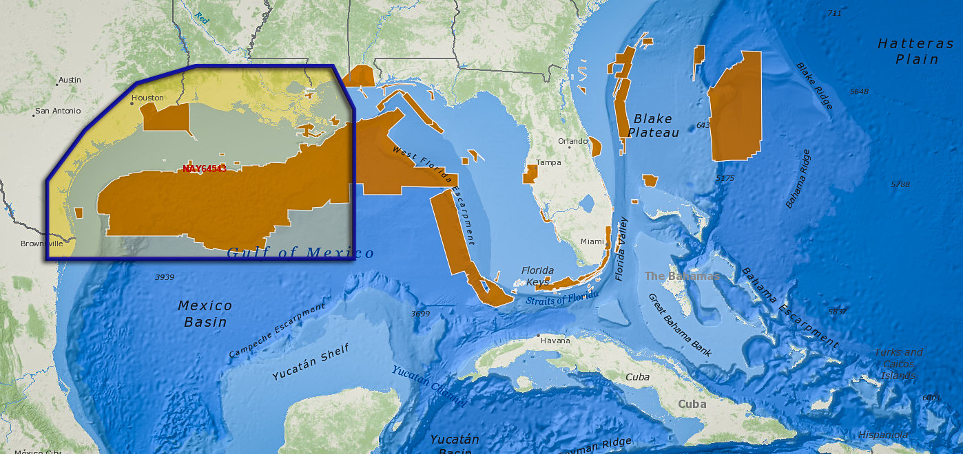
Below are the coverage maps for the three C–MAP Reveal charts that will ship in April. The darker-shaded areas feature high-resolution, C–MAP Reveal sea-floor coverage. The lighter-shaded areas also include full C–MAP navigation coverage including, High-Res Bathy, Genesis Layer, Custom Depth Shading and Satellite Imagery.
-

- M-NA-Y643 Florida and the Bahamas

-
- M-NA-Y644 St. Lucie Inlet to New Orleans
-
- M-NA-Y645 New Orleans to Brownsville
Related Posts:


Panbo publishes select press releases as a service to readers and the marine electronics industry. The release contents do not reflect the opinion of the editors and are not fact checked by the editors


