
iPhone/Touch nav, yet more news
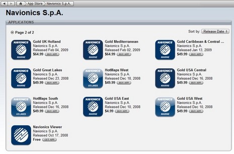
I don’t usually write about rebates and sales, but 90% off!?! Navionics not only launched version 2.0 of its Mobile app yesterday, it’s slashing prices. Here’s the press release, and note above how the whole Gold USA East chart portfolio dropped from $50 to $5. Apparently all the chart region prices will follow — at least to some degree (British Columbia now $10) — in the next few days, and stay bargain priced for “a limited time this summer.” A month ago I noted how fast iPhone/Touch navigation is moving, and it hasn’t slowed down…
According to Kurt Schwehr’s always fascinating blog, “the folks at NOAA said that in recent months, two thirds
of their downloads of NOAA raster nautical charts (RNC) are coming
from the iPhone via the iNavX
application.” Meanwhile, thanks to X-Traverse and numerous cartography suppliers, iNavX now claims an enormous online chart catalog. Mind the price and licensing details, though. For instance, X-Traverse is now serving all CHS (Canadian) charts and they can be assigned to two platforms — an iPhone and a PC running either MacENC or FugawiENC — but they’re pricy and you’ll need to resubscribe after 365 days. Navionics charts only work on the iPhone, but they last 730 days. {Correction, a happy one: “subscription” only means available for download; once downloaded you can use the charts forever (see GPSnavX comment below)} I am glad to see that Navionics’ new low, low pricing seems to be coming to X-Traverse, too, because remember that Mobile Navionics charts don’t work with iNavX and X-Traverse Navionics charts don’t work with the Navionics’ Mobile app.
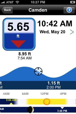
I’m trying both those apps now. I’ve got Mobile 2.0 running on a loaned iPhone and iNavX on my own iPod Touch. The iPhone pleasantly surprised me by finding my location inside my office though it had been shipped hundreds of miles while turned off, and I figured out how to use the wonderful utility Franson GPSGate to serve GPS info to iNavX via my home WiFi network. If I can get that to work on the boat, which is going to be harder, iNavX will display all sorts of real time sensor data. While the new Navionics Mobile now has rudimentary routing — and a stunning new tide and sun/moon function (seen below) — iNavX is clearly better at plotting, and especially instrumentation, but it has not yet adopted Mobile’s vastly improved chart query method. I’m going to test both apps more, of course, but they are fast moving targets. The Navionics charts, by the way, look great and zoom/pan fairly quickly in both; and with this sale on, it seems like any boater with an iPhone or Touch ought to check them out.


Just a point of clarification, once the Navionics or CHS charts are downloaded from X-Traverse onto a device, they may used without any expiration limits. The X-Traverse term of 1 or 2 years is the period the user has after activating the charts to download the charts. Of course with the x-traverse subscription comes the ability to transfer waypoints, tracks, and GRIB weather forecasts in addition to chart downloading.
Currently in the ITunes Store, only the Easy Coast is $5. All the others are at the original prices ($49.95). I am not sure if this will change.
Also, I have been using the IPhone version since its beginning. I purchased the Western US apps as well as the original viewer. I updated to Version 2 yesterday. The original viewer is updated, but the app that is for the Western US did not update.
I sent an -mail to Navionics to find out if the upgrade was suposed to upgrade the existing apps or if we have to pay again.
Thomas, All the regions will get updated to the 2.0 viewer and sale pricing, but apparently it’s hard to say when because each has to go through Apple’s validation process. I’ve had the East Coast region for a while, and it got updated to 2.0 last night, so I think your’s will too, once West Coast 2.0 releases.
I have been using INavx on my IPHONE for 3 months now and love it.
The other night I was anchored in Eatons Neck and it really started to blow hard.
From the comfort of my bunk I opened my iphone to make sure I was not dragging.
How cool.
Many kudos to Navionics for offering this temporary reduced pricing on their charts. I was left with a bad taste in my mouth when I paid full price for the early version of their 16XG US East Coast Charts, only to find they were incompatible with iNavX2 due to restrictions imposed by Apple. I think they have found a fair way to make things right, and now my mouth is minty fresh!
The same new low Navionics pricing also applies to the Navionics charts available for iNavX at http://www.x-traverse.com
As the new pricing comes online, the Navionics prices will be updated at http://www.x-traverse.com
Just downloaded the app, it’s a fantastic tool for planning at home, and you can never have enough backups on the water.
It appears as though the pricing has been updated for almost all map regions now. It’s nice to see a manufacturer pushing technology forward, even if it means reduced profits in the short term.
The Navionics offering is just amazing value package. Get charts for BC in an adequate viewer. The vector charts are so much more usable than the chs raster charts. The navigation aids resize so even at small scale they are viewable.
How does iNavX compare with the Navionics 2.0 program? I am considering getting one of them.
Thanks!
iNavX offers several features not found on the Navionics app. They include the ability to upload/download user named waypoints and track log (GPX and KML), GRIB weather forecasts, access to 1000’s of charts from: NOAA, CHS, Navionics, NV.Verlag, Solteknik and TRAK maps, NMEA via TCP/IP including AIS target plotting, True and Magnetic bearings, real-time navigation to a waypoint (bearing, distance, cross track error, estimated time).
More here:
http://www.inavx.net
I’ve got iNavX, Navionics Mobile 2.0, and Navimatics all running on a borrowed iPhone now, and will produce a screen shot slide show later this week. So far, though, my impression above remains the same: iNavX is better at navigation, and supports an amazing portfolio of charts via X-Traverse, but Navionics is doing some great stuff with chart information. For instance, if you tap on a marina, you can then call its phone # with just one more button tap. And the included Navionics tide and current app is fabulous.
Ben, just a quick update on the Navionics Mobile special promotion… we’ve put the special promotional pricing on ALL our apps so while you’re waiting for your region to become available in the new 2.0 version, you can enjoy the crazy low prices now! There are now several 2.0 apps already available… more coming soon.
The Navionics 2.0 software is a great step forward over the previous (1.6). Far faster re-draw, with google-maps style partial redrew for speed.
The representation of tides is great too – I like the ability to scroll along the graph rather than having to select a day at a time.
All in all, great progress and I hope they roll out the European versions sooner rather than later!
Most of Navionics Mobile regions are now available in the new 2.0 version on iTunes, European regions too. Updates are free!