
Hemisphere GPS compass; from ComNav, Si-Tex, & True Heading!
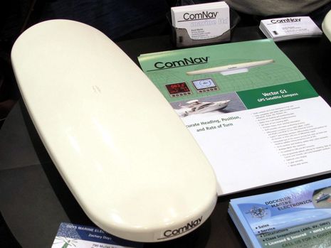
I first saw this notably svelte GPS compass — it’s only 16.5 inches long and less than 3 inches high — at the Miami Boat Show, as the ComNav Vector G1 (PDF here). It measures not just heading (to 0.6° accuracy) but rate of turn, pitch, roll, heave, position, COG, and SOG, and it can purportedly deliver all this data via NMEA 0183 or 2000, some at up 20 Hz (i.e. 20 updates per second). When Si-Tex recently introduced a very similar looking device dubbed the Vector 3D, I started poking around and discovered that at least the basic technology is actually built by Hemisphere GPS as the V102 and it’s also sold as the True Heading Vector Carbon. I have no problem with multi badging of products like this, but it seems like it takes the literature from all these models to best understand the device, and there are still some mysteries…
For instance, Hemisphere’s otherwise comprehensive online manual doesn’t even mention NMEA 2000, though its unit is in fact listed as N2K certified, as are the similar True Heading and ComNav compasses. But it wasn’t until I looked at some video clips on the True Heading site that I realized that the NMEA 2000 output comes from a translator module that screws into the standard port and therefore lives external to the casing. Now it may be that ComNav and/or Si-Tex have a different way of doing this, but if they don’t then the pole mounting seen below isn’t going to look quite so clean. (Note too that the Hemisphere manual states that such a pole mount fails some vibration standards.)
On the other hand, True Heading doesn’t mention the “Coast” technology touted by the others, a features that purportedly allows “Hemisphere GPS receivers to utilize old differential GPS correction data for up to 40 minutes without significantly affecting the positioning quality.” And not one of these brands list the NMEA 2000 PGNs the device outputs, not at least where I can find them. {Correction: The PGNs are listed in the Hemisphere manual, starting page 26.} And that may be fairly significant as I recall hearing that the possibly valuable Heave data this motion sensor puts out may not be included in a standard N2K message. One sign of that is that Furuno uses a proprietrary Heave PGN in its SC30 GPS compass, a fact you can verify in the manual along with all the standard N2K PGNs the non-certified SC30 puts out. (Yes, it seems fair to wonder why listing PGNs doesn’t seem to be part of the certification rules NMEA is so alarmed about. {Correction: Listing PGNs is a certification requirement, but the content of the PGNs, beyond network necessities, is not, which is interesting in this case because Heave does not seem to be output as a standard or proprietary PGN.} )
At any rate, I once saw an SC30 deliver amazingly fast and sensitive heave information, but I don’t know if it could be used to compensate for wave motion with anything but Furuno’s own fishfinders or side scan sonars. Nor do I know if there even are other sonars that know how to compensate for heave, though the Si-Tex Vector 3D release seems to suggest that, or how they’d get the data. I do know from trying an SC30 on Gizmo last summer that it can deliver phenomenally accurate and stable heading data to every NMEA 2000 MFD I tried, though it does need a good sky view and it is significantly larger than this Hemisphere etc. model.


I have the earlier version as an oem board. Only does 0183. Good product. Coast uses the onboard accerelermeter and mag compass to provide a DR input to the position and heading.
Dave
hmm this makes me wonder if there is an i-app for this sort of thing? there are certainly good (?) compasses on the ipad, but surely with the accelerometer onboard most/all pads these days then pitch/heave/roll could be readily programmed… I’d buy that app -rather than having yet another ‘gizmo’ (no offense!) in my cockpit….
I tested some of the first commercial applications of this technology as pioneered by the offshore surveying company Fugro. The key to this technology is sensor separation and accurately knowing the position of the sensors. You also need a good Vertical Reference Unit (VRU) to measure the vessel’s motion.
These companies have solved part of the problem by integrating 2 gps sensors in the same housing but, in doing so, they place the senors too close together to provide truly accurate results. So, with this design, I’d be looking at options with larger antennas then it’s critical they are mounted securely to the boat.
You could not do this with an iPad because it only has one gps sensor… it’s possible to write software to link two ipad’s together but then you’d basically have to glue them to the deck.
Dan, this sort of thing can’t be done with an iPhone a satellite compass uses dual receivers and a phase measurement system to determine heading even if stationary. It’s the best way I know of generating stable fast heading data. You should see these in use when feeding a MARPA display.
John I agree re antenna seperation on my Vector OEM board the antennas are separate. I use two Garmin antennas. The recommended distance is about .7 of a metre.
Dave
Could you compare these devices to a traditional rate gyro a little:
– Are these products (any of the three offerings) for sale yet?
– To what extent would you consider them a replacement of a traditional rate gyro (including economically)? I am/have been planning for an Airmar H2183.
– For an application on a sailboat, good sky view can really only be achieved on a radar mast at the transom, or, with limitations, on the stern rail. Clearly, the mast top isn’t suited. Does this satisfy “mounted securely to the boat” if done well? I have doubts if even the short pole shown in the picture can introduce a vibration problem.
– What is the power consumption?
– Is it correct that the output is true heading? If so, do they also compute/output magnetic heading like an ordinary GPS would (based on COG) as these have a magnetic world map stored?
I just made a correction in the entry because it was pointed out to me that the Hemisphere manual (also used by its OEM customers) does list PGNs, and that such listings are required for NMEA 2000 certification.
Interestingly, though, I’ve confirmed that Heave is not in a standard N2K PGN (yet) and whereas the Hemisphere doesn’t list any proprietary PGNs, it may not be available from this sensor via N2K. In other words, there seems to be no requirement in NMEA certification that the data listed in a product’s specs is actually available via the standard, which could cause some angst!
Henning, I do believe that these products are available, and the PGNs will help you understand what they offer. They do output full GPS data, including magnetic variation, which can be used internally to correct the native magnetic heading to True. My experience with GPS Compass/Motion Sensors is limited to the Furuno SC30. It was phenomenally accurate, responsive, and reliable when mounted on top the Simrad radar on the front side of Gizmo’s flying bridge, but would occasionally lose satellite lock when mounted on the aft cabin top about four feet aft of the antenna mast.
The hemisphere Vector unit has been available as an OEM product for about 4 years. And hemisphere can a boxed version for that time too. Distribution was very specialised.
I can confirm the unit lives up to it’s claims. Satellite compasses are in my view the next ” must have ” device in electronic nav. Prices are dropping and performance is very good, much better then so called solid state rate gyros coupled to fluzgate compasses.
Dave
Hi Ben,
Thanks for your post Re: “Hemisphere GPS compass; from ComNav, Si-Tex, & True Heading!”
Yes, the unit is very “svelte.” In fact, it’s the smallest GPS compass on the market today.
I wanted to take this opportunity to address a few of the points in your blog post:
Hemisphere GPS V102 compass and Hemisphere GPS MV102 (OEM branded) compass are two separate products which share similar but not identical family features.
Hemisphere GPS’ V102 compass is not NMEA 2000 compatible but does support NMEA 0183. Therefore, Hemisphere GPS’ V102 is targeted at other markets such as machine guidance applications.
Hemisphere GPS’ MV102 compasses designed for OEMs (such as True Heading Vector Carbon, ComNav Vector G1, Si-Tex Vector Pro G1 and other OEMs) support both NMEA 2000 and NMEA 0183.
As for the “translator module,” it’s the hardware and software of the OEM branded compasses which allow for both NMEA 2000 and NMEA 0183. The “translator module” you suggested is simply an adaptor to go from a 12-pin NMEA 0183 connector to a standard NMEA 2000 5-pin connector.
We feel the appearance of the unit with the NMEA 2000 adaptor is still very clean and sleek looking which provides a convenient way for our customers and OEM to use their own NMEA 2000 cables. See the following link for a couple photos of the adaptor: http://www.mediafire.com/?dfcq7g96jqwza
Yes, both the Hemisphere GPS V102 compass and Hemisphere GPS MV102 (OEM branded) compass support our patented COAST technology along with other proprietary technology and features
Currently, both Hemisphere GPS V102 and Hemisphere GPS MV102 (OEM branded compasses) only support heave messages in NMEA 0183 and do not support heave messages in NMEA 2000 because there is no standardized NMEA 2000 PGN for heave
Once again, thank you for the article and we appreciate your editorial support. If you require anymore information on Hemisphere GPS products, please feel free to contact me directly.
Ryan Warehime
Corporate Communications
Hemisphere GPS
Ryan,
The specifications for the Hemisphere GPS says it updates 10 times a second – and up to 20 times a second.
Does that mean that it can update a MARPA system – which normally requires a rate gyro to work ?
Hi Andrew,
Mini Automatic Radar Plotting Aid or MARPA automatically tracks acquired targets, calculates target bearing and range, true speed and course, closest Point of Approach (CPA), and Time to Closest Point of Approach (TCPA). Our heading device can attribute to the system by providing heading, position, or any other NMEA sentences at 10 to 20 Hz data rate output.
Thanks,
Ryan