
Garmin 2016: Quickdraw sonar charting, smaller Panoptix, Striker, and lots of CHIRP
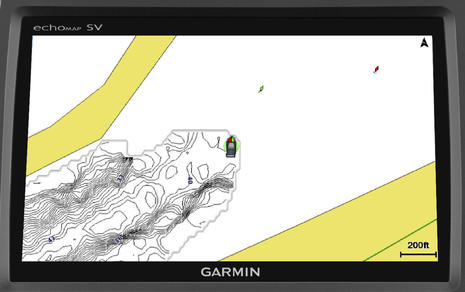 Garmin put up a Marine 2016 site this morning and one thing many current Garmin owners will be excited about is the Quickdraw Contours sonar charting that will come to many current Garmin displays in January. Yup, you’re going to be able to easily collect soundings as you cruise, sail or fish and, if you want, you can watch the resulting high def sonar chart materialize in your wake, as suggested above. Quickdraw is no surprise given the tussle over Navionics SonarCharts for Garmin, but naturally Garmin added some special sauce…
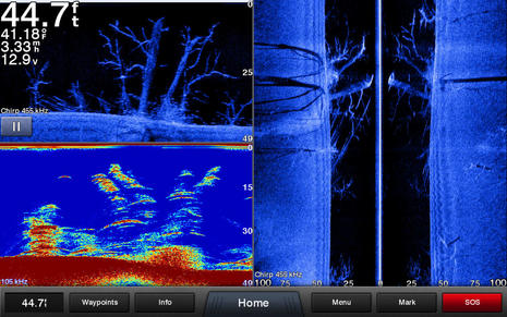
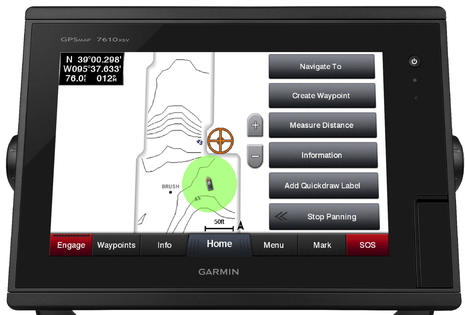 With Navionics SonarCharts for any marine display or Navico’s Insight Genesis, you have to submit your collected soundings and later download the processed results before you can see them on your MFD. Quickdraw is instantaneous, like Live SonarCharts on the Navionics app (or Humminbird’s Autochart Live). You can also add point of interest information to your Quickdraw chart, set depth range colors and other custom niceties (as illustrated by the screenshots I wish Garmin would make larger).
What’s not clear yet is how Quickdraw users will be able to share their charting with other users or with Garmin, but I know they’re working on it and trust that the process will be easy when offered.
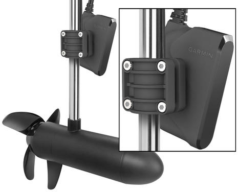 And yes, Panoptix users will be able to collect Quickdraw data almost as if they had a real cartographer’s multibeam sonar, and, what’s more, Garmin will soon offer a new smaller and less expensive PS21 trolling motor transducer. It will only do the LiveVu, not the 3D mode (that needs a big screen anyway), but marine product manager David Dunn — who showed off the original Panoptix, SideVu, and the VirbXE integration at NMEA — told me that PS21 testing is looking very good.
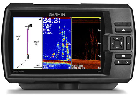 Dunn is also excited about the “full CHIRP” that Garmin is putting in the new value oriented Striker fishfinder series, which also include GPS for waypoint tracking (not charting). “Everyone has their own definition of CHIRP when it comes to this level of fishfinding,” he tried to say diplomatically, but Garmin’s is “more like Airmar’s” with transmissions that cover full ranges like 90-120 kHz.
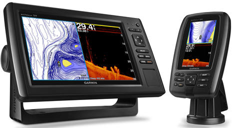
 Garmin is also introducing a slew of its own transducers, including the GT52HW-TM seen above showing what it can do with “high-band 150-240kHz CHIRP traditional, 455/800 kHz CHIRP DownVü and CHIRP SideVü.” And they’ve added full CHIRP to the echoMap line, which will also be able to do Quickdraw charting and/or work with Panoptix. I would have listed some of the prices, which seem good, and other features, but I’m headed out the door to Raymarine and Navico demos, including StructureScan 3D. The sonar wars rage on!


So Striker is Garmin’s answer to Humminbird’s HELIX 5 and 7. Will be interesting to see Lowrance’s 2016 lineup. It’s looking like a race to the bottom for the so called “budget” fish finders. Unique sonar capabilities like 360 Imaging and Panoptix will become the differentiating factors.
Any chance theres gunna be a Navico update to do the same thing? My assumption with the other sonar chart making systems was that they wanted you to upload them to use them so that they would end up with a big database of user generated sonar charts.
My concern with “user generated sonar charts”, or user generated content in general, is the veracity and applicability of it. Here in North Carolina, depth is influenced by wind direction and velocity. We have wind driven tides, in other words. If someone reports a depth sounding, I want to know which way the wind was blowing and how hard to determine if that depth is influenced by wind direction and velocity. Similarly, when someone reports a depth in the AICW, for instance, I want to know the state of the tide: falling or rising and at what level. Giving me a depth reading of 10 feet is meaningless if it was taken at a full-moon high tide because I will be transiting that area at low tide and find 3 feet of depth!
Can someone explain how we are to interpret crowd sourced data?
Thank you.
Garmin has been providing excellent devices and 2016 won’t be any exception. I wonder what other technologies are coming besides crystal clear down imaging sonar. I guess we have to wait.
Big Garmin update out today with some the features discussed in this entry, like Quickdraw Contours and multiple depth range shading. It also sounds like some Garmin radars will now be able to do dual range, and with chart overlay on both if desired. And more…
http://garmin.blogs.com/my_weblog/2016/02/garmin-adds-quickdraw-contours-more-in-latest-update.html#.Vs8dZOaaXwg
If you’re still boating, please let us know how the update works out.
After updating a 7400 (7600) unit I found out in the communications part of the Settings menu a box appeared with
J1939 setup I know the new 8400/8600 have J1939 input on the back but 7400 does not have that port wonder how the are going to that ..
The same way the Coast Guard or the Army does it.
These systems are smart enough to take into consideration the tide. In practice, its not just a single set of data that is being used to generate the depth soundings – many boats under many different environmental conditions are running through the area recording the bottom over a period of time and adding that data to a unified centralized database.
For areas that have a lot of traffic there will be a lot of boats recording data. For those with less traffic, less data.
Like ANY chart data – use at your own risk but in practice its generally a lot fresher and accurate than 20 year old official depth data.
Garmin just made it easy to share Quickdraw charts:
https://www.garmin.com/en-US/blog/fishandhunt/garmin-quickdraw-community-icast-2016/
The Garmin sonar feature is very successful. my Garmin striker 4, small but successful in finding fish