
Here comes 2007, ENCs + GE = EarthNC
It seems obvious that Google Earth and similar online mapping systems that allow users, individual and otherwise, to create their own overlays will somehow figure in the future of marine navigation, at least for sharing POIs and planning. But, get this, a small Florida company, DestinSharks.com, is already translating NOAA vector charts (ENCs) into Google overlays they’re calling EarthNC charts. I heard about it (thanks, Rich and Rich), signed up for the public beta test, and am impressed.
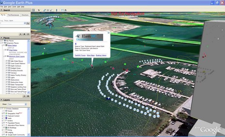
I was getting fancy in the screen shot above (bigger here), using GE’s tilt mode and 3D buildings, but check out how neatly the nav aids, bottom contours, and dredged channel lines lay out, and how (left) you can control overlay elements in familiar GE fashion. But I do hope they figure out how to round the depth soundings back to their original paper chart equivalent (a vector issue I’ve complained about before). And I did see registration issues between some EarthNCs and GE satellite photos (though in this case, Miami’s Sea Isle Marina, the charted pilings seem to line up perfectly). DestinSharks, by the way, is “planning a DVD edition which will offer the full chart set for offline use”, and Google recently added photo maps of my home harbor that are almost as detailed as the most zoomed-in marine panoramas I’ve seen (so far). What else will 2007 bring?
PS 12/28: I came across the fact that Google Earth was downloaded 100 million times during the ten month period following its June, 2005, release as a free program. Yow!


Wow. I can’t wait to play around with that. I regularly use a 3d Connexion spaceball for cad, and it interfaces with GE. Using it whilst navigating would be fantastic.
Yeah, DestinSharks has been one of our favorite online destinations. We have been working on how to get their service linked into our (and others) blog.
We have a products category where we discuss ideas like this, as well as many topics from Panbo.com. You can see our product blog at:
http://www.marinernetwork.net/?cat=6
I have been doing similiar things using GDAL/OGR to read S57 and write out kml GoogleEarth files. You can download a sample kmz for the Norfolk area. Instructures are in a post from earlier this month.
http://schwehr.org/blog/archives/2006-12.html#e2006-12-29T17_17_30.txt