
Vesper Marine Virtual AIS Beacon, and more
![]()
That’s New Zealand’s fascinating Fiordland coast and while I’m not positive the photo was taken from a helicopter, I do know that the solar-powered navigation light in the foreground is serviced by one. Which is how the technicians who recently added an AIS transponder to the site got there too. But you won’t see the nav light on an AIS plotting screen because the transponder is programmed to mark a dangerous submerged rock at the mouth of Doubtful Sound 3.4 miles in the distance. Now the visiting cruise ships report that they can now plot Tarapunga Rock from 10 miles offshore or from two miles inside the Sound. The concept is called a Virtual Aid to Navigation, or VAtoN, and while it’s the first I know detail of, I’m doubtful that it will be the last…
The authorities used to mark that rock with a bouy but big seas regularly destroyed it so now they’re trying Vesper Marine’s new Virtual AIS Beacon. On that Vesper page you’ll find links to more interesting detail on the Tarapunga Rock beacon, but note also how the hardware can create up to 50 virtual aids to navigation. So at least within VHF transmit distance, a VAtoN administrator with a single Vesper Beacon system can create a virtual channel or cordon off some sort of temporary event.
Note too that marinas are listed as possible users of this technology. In fact, Vesper founder Jeff Robbins told me that they have set up a test marina with an AIS slip guidance system. When a boat calls in for a reservation from outside the harbor, the dock manager can easily light up their particular slip as an AIS target. Which would beat the heck out of all the chatter I often hear as dock masters try to help someone find a particular spot in a complicated harbor. And if the arriving vessel is also transmitting its AIS ID, the Vesper system can even turn off the virtual slip target when the yacht arrives!
![]()
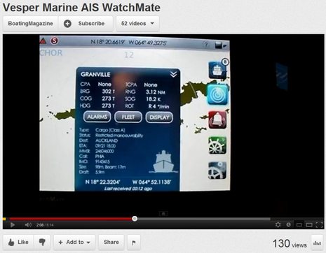
Vesper Marine is on quite a roll. The Virtual Beacon is a finalist for an NZ Hi Tech Award after recently receiving Professional Mariner’s Samuel Plimsol Award. And in Miami, Vesper won a Safety category Innovation Award for its WatchMate Vision touchscreen Class B AIS transponder. You may recall a Panbo preview of the Vision last November, but sorry to say that it’s not yet shipping or on Vesper’s site. I’ve had a hands-on demo, though, and was very impressed. Part of what I saw is in the Boating video seen below, but there’s more to Vision than just great AIS plotting. Details soon hopefully.


I worry that mariners may mistake a Virtual ATON on their screen with something they would look for out their window. Not a big deal until things get stressful and someone forgets the “virtual” part. If this is a fixed point, why isn’t there something big and obvious on the chart??? I first saw virtual atons shown in use at the AIS 2006 conference I think. I have argued strongly against them and strongly for proper chart updates. I’d love to hear an argument counter what I think is the best approach.
Hi Kurt, I gather from the GLA site that there are different icons for the different types of AIS ATONs, but I’ve never seen them in action:
http://www.gla-rrnav.org/radionavigation/ais/index.html
I suspect you’re right that it will take some getting used to, but I can see how governments might start to question the serious expense of maintaining actual navigation aids. A long time ago I heard that Canada was considering eliminating some aids simply because good GPS makes them unnecessary. I found this 1997 study that seems to at least confirm the concept, but I don’t know if anything came of it: http://goo.gl/839d5
I like the concept very much. It is not a replacement for traditional aids to navigation, but it certainly makes it safer to navigate unfamiliar waters. For example, a new hazard happens, within hours the AIS ATON could be broadcasting. It would take significantly longer to install a traditional marker.
My kind of technology, inexpensive, functional, and useful.
Patrick Harman
My congratulations to Vesper Marine. I’ve been using their products for a few years now and have been mightily impressed with their technical acumen and customer service focus. Great stuff.
On the topic of Virtual Aids, I get a little nervous at the prospect of “real” bouys disappearing. I’m now near the end of a 30 year career in Information Technology and I know just how bad things can get when the stuff fails. Yes, there are six GPS receivers on my boat, but also two sextants 🙂
That said, I think we’re just beginning to tap into the tremendous potential of stuff like AIS to improve the lot of both professional and recreational mariners.
Cheers, Bill
I agree with Kurt. If you can see it on the chart, you shouldn’t smack into it, but on the other hand I like the concept for several reasons. Marking a hazardous wreck, or other objects that for whatever reasons are not on the charts is one of them. Pulling into an enormous marina with a zillion piers, and seeing your dock on the chartplotter is also one. On the other hand I would hate to see my displays cluttered with AtoN’s showing the locations of the Salty Gizzard Bar, and Bob’s Surplus Marine Parts. There should be some sort of a line here, like you can’t use it for advertising. Hey, wait a minute, let me think some more about this. Maybe this a real money maker, it wouldn’t be illegal would it? Could you make a custom icon for the Salty Gizzard Bar?
I would like to see AtoN’s for hospitals, with contact numbers and best shore locations to transfer injured crew.
Also, we have some floating docks in our harbor that are hard to spot at night.
As far as advertising goes, a good restriction is that it is positionally correct. E.g. Don’t advertise in the middle of the water for locations along the shore (e.g. advertise for a marina, gas, West Marine, or other locations in the middle of the water)
Wow… it didn’t take long to go from marking rocks to putting advertisements on AIS.
Scary…
Golly, with the ATON and enough electronics I can send the boat on a autonomous cruise while I stay home and earn money to pay for it all…
denny-o
Congratulations to Vesper for a nice product.
But I rellay must say that Virtual and Synthetic ATON functionality been a part of the ATON standards IEC 62320-2 and IALA A-126 since 2006 🙂
According to ITU-R M.1371 (the standard defining the structure for all AIS messages) the virtual ATON targets shall have an indicator in their messages, so a presentation system can differentiate a real from a virtual ATON target.
An AIS Base station can transmit any AIS message defined, so the need for a special ATON to transmit Virtual-ATON targets is not really needed if the coastline has the proper infrastructure.
For those curious about AIS symbols: The standard defining symbols and presentation surface requirements in general for the professional SOLAS market is called IEC 62288. The symbols at http://www.gla-rrnav.org is unfortunately not really correct, but close.
“A virtual AIS ATON shall have the letter ‘V’ superimposed on the symbol so that it does not extend beyond the diamond and does not intersect with the crossed lines. ”
I love the concept – imagine if ATONs could be placed in every location where they would do good, not just where bottom conditions were right for anchoring and in numbers limited by budget cycles.
I wonder, however, if there are physical limitations to the number of AIS signals in a given area. How much “bandwidth” do the AIS frequencies have?
There are 2250 transmission slots per channel and minute, which makes 4500 slots in total as there are two channels. This is usually plenty, but can be a problem in crowded areas. Especially for AIS Base stations, typically located in an elevated position for better coverage.
The problem with an ATON is that they do not “pre-annonce” coming transmissions as a normal Class A AIS unit does. It is therefore not a good idea to send a lot of Virtual ATON information from an ATON station.
An AIS Base station would issue a separate “pre-announcement” of slots reserved for own station use, and then use those for Virtual ATON transmissions.
In the coming years we may see two new AIS frequencies, where we can get really creative.
The two we have today should be kept for position reporting only, as it is the main objective. This will of course require new equipment for those who would like to use the “extended” AIS features. I can say there is no lack of information various parties wants to transmit over AIS today…
I really believe we should not add more data traffic than absolutely nescessary to channel AIS 1 and AIS 2.
/Johan
Thanks Johan for the excellent technical info. One minor clarification… the “pre-announcement” of slots is only needed for a Type 1 AtoN. It isn’t needed for a Type 3 that has it’s own receivers and can use a different synchronization method. The Vesper Marine beacon can be configured as a Type 3 since it may be autonomous and used in remote locations where a basestation is impractical.
You are correct regarding the total number of slots, but also keep in mind the transmission interval of an AtoN (typically 3 mins) is much less than a vessel’s position reports (2-30 seconds) resulting in much lesstraffic.
Lastly, in extremely crowded areas a basestation can currently be employed to alter the reporting intervals and operating frequencies of existing vessel transponders. This allows for separate “networks” in different geographic areas. No additional hardware is required for this on the vessels.
Hi Jeff,
I agree ATON traffic is normally not a problem (reporting at 3 minute intervals, with alternating channels).
Having 50 synthetic targets sounds a bit much, and makes me curious on how it is feasible.
Does the station use:
FATDMA (fixed scheadule, shall be pre allocated from base station)
CSTDMA (Carrier Sense, listen before transmit) or
RATDMA (Random from perceived free slots) for the synthetic targets?
I was under the impression that all ATON position messages (Msg 21) are two slot and may therefore only use FATDMA (requiring an AIS base station doing reservations), or RATDMA.
Regarding channel management by base station to create separate “networks”: It is not a requirement of Class B transponders today to be capable of channel management. So you would have mixed results if a base station issued a frequency change command. Some would change, others not. Not very nice at all 🙂
Best regards,
Johan
By the way, I may come off a bit negative. But I belive AIS ATONS are a great thing. One of many exiting applications for AIS.
/Johan
It’s a nice idea, but as Johan mentions virtual and synthetic AtoNs have been around for a while. They’re already in use to mark wind farms in some areas and broadcast either by a coastal base station or a real AIS AtoN when far offshore.
I believe Johan is technically correct on the ‘pre-announcement’ issue. The issue here is not pre-announcement of the FATDMA slots used by a Type 1 AtoN where the pre-announcement (or rather slot reservation) is done by a base station.
Type 3 AtoNs use RATDMA which randomly allocates empty AIS slots for transmissions based on prior knowledge of slots used by other stations. What they don’t do is ‘pre-announce’ their intention to use these slots to other stations (which Class A AIS, using SOTDMA does). This leads to inefficiencies in the use of the available slots, so it’s not great to ‘rob’ lots of RATDMA slots for virtual AtoN targets, particularly in areas with heavy traffic.
NB – in the US at least all AIS AtoN installations need approval from the Coast Guard (see http://www.navcen.uscg.gov/pdf/AIS/USCG_AIS_Aton_Application_v4.pdf) so don’t expect one on your nearest floating restaurant any time soon 😉
All AIS stuff including AtoN can be very useful but please be aware that thousands of vessels do not have layered electronic charts to show the targets.
Bill, I don’t think we’ll see advertising AIS AtoNs soon, but when VAtoNs were discussed at a GMDSS meeting a couple of years ago, I did ask a USCG representative about the concept of marinas identiying themselves. He didn’t say “yes, sure” but he didn’t dismiss the possibility either. It’s interesting that the USCG and other authorities which actually monitor AIS traffic, and have done huge simulations, do not seem very worried about spectrum over crowding.
PS to all. I’m on vacation in New Orleans this week and, though I do have at least one entry almost done, things will be slow. I’m fooling with trackers like inReach again, though:
https://panbo.com/about.html#Where-At
Yes Johan, the Vesper Marine beacon can use either FATDMA or RATDMA. You’re right that it can’t use CSTDMA for message 21 since it is a 2 slot message. Other single slot messages can use CSTDMA, such as status messages.
The beacon isn’t intended to be a substitute for a basestation or used in it’s autonomous mode (Type 3) in areas with extremely heavy VDL loads. Rather, it’s ideal for locations where a basestation isn’t required or practical due to power or other environmental concerns. There are few locations where extreme VDL loads are an issue and in those locations it can just be used as a Type 1 since basestations would already be in use. It can also do a variety of other things, but an interesting one is you can use additional beacons to extend the range of either other Vesper Marine beacons, AtoN’s or basestations.
And just FYI… all Class B’s must have remote channel management capability. They don’t have to support the full band, but they must be able to change frequencies within a minimal specified range and they indicate their range within their transmissions. Basestation remote commands come from either AIS or DSC and all Class B’s must monitor DSC on a predefined schedule. Examples of remote commands are frequency changes, quiet periods, and reporting intervals. They can be directed to individual stations or groups of stations based on various criteria.
The USCG accidentally switched AIS channels in the Chesapeake and New Jersey area two years. That was a bit messy but apparently the whole process can be quite transparent to Class A and B operators. HOWEVER, boats with just AIS receivers — which know nothing about base station AIS controls — may just stop seeing targets on one or both standard frequencies.
http://goo.gl/Q7cHX
If VAtoN’s had been in place on the astrolabe it would have shown up on the AIS screen irrespective of the fact that the Rena crew thought they were 1 NM to the north of it, and spent the time they should have been avoiding the hazard by standing out on the bridge looking at the white water thru binocs and wondering what the *&^% it was.
That’s a pretty good argument for the tech IMO.
While I agree to an extent to what you say, Virtual aids to navigation are of immeasurable value in fog. And well… it IS foggy most of the time in teh standard heavily trafficked ocean routes of South China sea, Sea of Japan, Ports in China, japan and Korea, and in teh English channel.
As for being able to see these dangers, well, on a 200,000 tonner bulk carrier, I should NOT be close enough to be able to see a shallow patch!
In Shanghai river especially (where your paper chart will tell you that you are aground, for the river continuously changes course, depths constantly change, and buoys are constantly shifted based on the above, Virtual AtN is used to the hilt. Buoys can be spotted and named easily as the virtual AIS literally spells out it’s name. As for using one’s eyes, well – if it was not foggy, you still would be able to see the name only AFTER passing the buoy and running aground, as the number is written in Mandarin on the other side!
Virtual AIS in Japan –
Virtual AIS has been used in Japan since 2006 – especially in channels and straits with strong tides adn little sea room – Kurushima kaikyo, tomogashima kaikyo, the entrances ot inland sea (seto naikai), approaches to Oskaa, Kobe, etc. They transmit not just the position of the light house, but also the state of current at that moment.
I especially found this useful when on container ships.
Virtual AIS in China –
has been in use since 2008 – especially in Yangtze river (Shanghai). All pilots use it for reference on their laptop ECS. As a master, I found this of immense use tot eh bridge team, especially since on container ships, we did a different port in this area every third day, and by the time we returned after 3 months, the river would have changed course in some points and so had the buoys. This information, by the way, is never transmitted either by navtex of by Notices to mariners. Welcome to the real world.
Hi,
Virtual AIS has been used in Japan since 2006 – especially in channels and straits with strong tides adn little sea room – Kurushima kaikyo, tomogashima kaikyo, the entrances ot inland sea (seto naikai), approaches to Oskaa, Kobe, etc. They transmit not just the position of the light house, but also the state of current at that moment.
Hi Ben,
AtoN & VAtoN are great concepts, but both depend on your equipment being able to handle these message types.
My Raymarine AIS500 (interfaced to c125 plotter over ST2) does not see any AtoN transmissions, even when in direct sight of an equipped navaid.
Raymarine appear to have no plans for a software update, their view seems to be “it’s obsolete, the replacement AIS650 has this capability”.
Possibly merits another column in your “name & shame” AIS sheet?
Hi Ben,
I think the AtoN’s are a great idea, and like all ideas, have good and bad points.
My concerns is, If the equipment is possible to make a offset for a AtoN so that the transmitter is in one location and the reference point is in another location, and this becomes accepted practice, what then would happen if someone thought it was fun or in a time of fighting, decided to set the AtoN or a fake one, to a wrong location, so that people in poor visability crashed.
I think if We in NZ had been sensible, and actually put a Solar powered light on the rock of Astroreef instead of a offset one, the Rena would have been safe.
I also think it is time we reviewed the idea that it is ok to have a ship that cannot turn quickly due to size and stop quickly. The technology is there to do it, there is only no will to do so.
In the meantime, ships will hit each other and parked objects as they cannot manouver at a rate one one expects of smaller vessels.
http://www.cargolaw.com mentions I think, there is one big ship crash a day.
The other point is, why do the very big ships, where the bridge is so far away from the bow, not have a mini bridge, all nice and cozy, on the bow area, where the crew could get a better view of small ships in the way and be able to see things like reefs sooner.
They could report back to the bridge.
It is a bit like trains, cars all have ABS and some have radar enabled brakes, but trains which take miles to stop, don’t have radar assist or ABS on the steel wheels, and why on heck no one has invented a wee loco that runs 500 meters in front of the train to see the way is clear on tracks, and if not, brakes the big loco automatically, I don’t know.
It could have a camera feeding back to the loco driver and also take the brunt of a crash with any oncoming items.
But back to AtoN’s, definately a great idea, but potential for errors if someone plays with the programming, unlike on a ship, which is usually configured for only a minor offset.
Kind regards,
Michael.