Tender tracking, good for exploring too
![]()
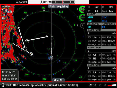
With so many megayachts in the world—some with extra large tenders that they have to tow offshore, some with wild and crazy champagne-guzzling jet-ski-riding charter guests—tender tracking is a big deal. The Nobeltec Admiral 9 Plus Pack looks like quite a complete offering, as seen in these screen shots, and I know that there’s another interesting product about to enter this niche. Some thoughts:
* I think Admiral can track more sorts of targets than anything else out there: MARPA, AIS, DSC, and now tenders. Won’t other navigation systems follow suit? And what new target type next?![]()
* The Seetrac transmitter/base station system that works with Tender Tracker (with Transas too) can also send wind info, using an option that sounds like the Airmar WeatherStation. Thus you could send your sailing yacht’s tender out to survey a race course America’s Cup style.
* By the same token, your tender can also send back depth readings. I’m not sure how they are displayed in Admiral, hopefully as a track of varying colors, but I do know that if you have the optional Bathy Recorder, the tender’s readings can rebuild the 3D data right ahead of your yacht. Yeah, you’d be down $2,300 just in software options (and I can’t find Seetrac prices), but how cool is that! (Actually, has any reader devised a poor man’s way to collect soundings from a dinghy, lead line excepted?)
![]()


I use a handheld depthsounder in the dinghy … about $100. That’s about as ‘poor man’ as I can find 🙂
Yup, handheld, here it is:
http://www.speedtech.com/asp/prodtype.asp?prodtype=33
Well, OK, but those are just electronic leadlines. I was thinking of something a little more sophisticated, recording soundings and GPS points in some way that can be shown graphically back on the mother ship. Couldn’t this be done with a portable plotter and a ‘smart’ (i.e. NMEA talking) depth transducer?
We have been trying something like that, but found it difficult to get a license-free transmitter with a range big enough to be of some use for remote sounding from the tender…
Check out the Brookhouse site. They have a device described as:
” The Brookhouse NMEA data logger is a compact device for recording NMEA data such as water-depth, coupled to GPS co-ordinates. The data-logger has been designed specifically for recording data used as input for the creation of bathymetric maps, but other applications are possible. When surveying, circumstances often do not allow the use of a (laptop) computer or other electronics with complicated operating procedures. Simplicity is a key requirement. The Brookhouse NMEA data logger is small, rugged and very simple to operate. At the front it has a LCD (Liquid Christal Display) and a sealed membrane keypad. There are 2 input ports for the connection of NMEA instruments: A GPS can be connected to one port and a depth sounder to the other. NMEA data is simultaneously read via the 2 ports and records are created with water-depth and latitude/longitude of the vessel�s position. It does not matter which NMEA data is input via which port and data may also be combined on one port. After all required data has been recorded, it can be downloaded to a computer. Application software can now filter out unwanted data records and the next step is to create a regular grid from the randomly dispersed data, using interpolation techniques. From this regular grid data a contour map can be created. ”
Dan
I have been wondering why we can’t update all the charts of the S Pacific from their Royal Navy version in the 1800’s to modern GPS charts. The Brookhouse NMEA data logger sounds like the solution. Over time you’d have enough data points you could make an accurate chart.
Panbo, anyone out there doing this already?
The data logger is what we use on board our customers (with their consent)
Basically we have an application that plays the data back into the 3D bathy software we distribute across norther europe.
Once a month we ask for the vessels to send in their soundings we ensure the sounder is setup with the correct offsets and this allows us just to play the sim files back.
Another option could be the new “N” version of the WIFI system that will give a great range boots simply use a piece of software to convert serial to a UDP packet that is transmitted across the network each tender can use a different network port and the main system would simply need to decode each ports lat, long, depth, time info as it comes in.
Maybe some cleaver developer could save up the data and put it into packets so that if the wifi is out of range data is stored up and then sent in a big hit once the wifi is back in range.
Andrew Murray
Murray Marine LTD
Tender tracking sounds like a fun and safe use toy. good for poking around in shallows .