
Sonar wars: Navico StructureScan HD & Humminbird 360
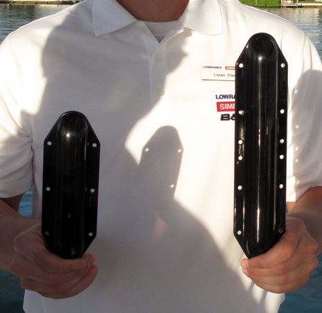
Yes, there was some jocularity in Miami about the manliness of the new Lowrance StructureScan HD transducer, once it was whipped out by Lucas Steward (of tricked-out Hobie Pro Angler fame). But more impressive than what an SS HD user gets to show off at the launching ramp is what they’ll see on screen. Navico has managed to give StructureScan more range and improved resolution while also simplifying its use and keeping the price the same (at about $600 for the new transom transducer and LSS-2 module)…
What makes the second generation StructureScan easier to use is that it only runs on one frequency, 455 kHz, instead of two. That’s because Navico sonar engineers were able to narrow the 455 beam width with that longer transducer and thus the higher 800kHz resolution of the original model was no longer needed. I frequently change frequencies on the original as depth varies, trading detail for range and vice-versa, and I wouldn’t miss those trade offs at all!
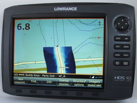
Having used StructureScan myself for two seasons (last major entry here), I can report without reservation that HD is better. When we weren’t being chased off by harbor police, we scanned a variety of depths and structure around Miami Harbor and HD’s ability to reach out further to the sides, and down look with greater detail, were obvious. HD also worked nicely with the StructureMap option that was discussed here along with Lowrance HDS Gen2 displays in December. Plus I’ve learned that boaters without Gen2 can generate StructureMap style overlays, and even view them on an iPad, using DrDepth software tools (which I intend to try with some of the SS files I saved last summer). And I have no doubt that StructureScan HD and StructureMap will be coming to Simrad systems eventually. All good!
While Humminbird — whose Side Imaging was once a match for StructureScan, I thought — has yet to counter HD, the company caused a stir with the announcement of 360 Imaging. The technology surprised me too. For years I’ve been trying to explain to people that the narrow beam sonar used in Side Imaging and StructureScan couldn’t look ahead because it can only build up a usable image from side slices. But it didn’t occur to me that you could take a similar transducer and spin it at the bottom of a transom-mounted pole! Say hello to Humminbird 360 Imaging, due out in August for about $2,000…
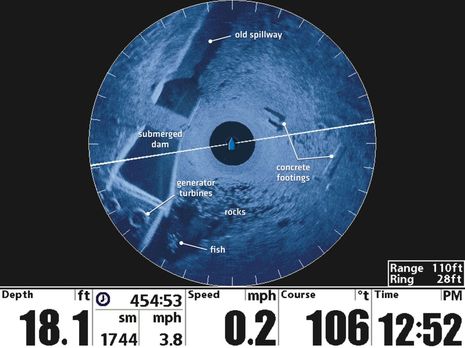
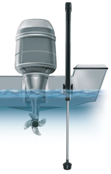
So 360 Imaging is vaguely like commercial side scan sonars, except with the structure detailing (and short range) of high frequency and ultra narrow beam. You can just sit still and look all around or you can command the transducer to limit scanning to a sector ahead as you motor along slowly. But while it may be great for the freshwater fishing market that’s core to these technologies, the transducer rig below would be hard to adapt to a saltwater cruising boat, and I’m not sure it would last. StrutureScan HD, however, will be even better for gunkholers like me than the original and let’s not forget that Garmin recently acquired Forward Looking Sonar pioneer Interphase. I’m really looking forward to what that combination will yield, and if I were working at one of the other Big Four, I’d sure be thinking about an FLS competitive stradegy. All good!


Some interesting LSS-1 versus LSS-2 testing on the HullTruth, but I too wonder if it’s a fair comparison in terms of the terms of the different model’s software development: http://goo.gl/LV2tq
I wonder if the patent war was the cause of the loss of the 800mHz frequency that WAS on the LSS-1 transducer/system?
I saw that on The Hull Truth too, Tony, but am quite dubious. The main instigator of the rumor seems to get contradicted by facts at every turn: http://goo.gl/C97z4
But if anyone is convinced that the dual frequency LSS-1 is actually better, there are some good deals on them while supplies last 😉
I am always on salt and sandy water and hardly use the 800kHz.
So I sold my LSS1 and am waiting for the LSS2.
see if it works.
There are some nice composite side-scan photos of the Titanic which were recently released. Goggle News “titanic sonar” gets hundreds of hits. This one includes some photos:
http://www.dailymail.co.uk/news/article-2112456/Titanic-pictures-Extraordinary-sonar-images-map-shipwreck-ocean-floor.html
They don’t say much about the equipment used.
I’m really not seeing much extra range in their video. One website says he’s waiting for the new software and his images are better than what Lowrance is showing in there’s. If you look at the Lowrance video you can see the black edges of the screen are void of information.. I’m not buying it.
The Lowrance specifications for StructureScan vs. StructureScan HD (from the Lowrance web-site) indicate no changes to the power output between the two systems:
Sonar Output Power is the same: 500W / 4000W (Max WRMS vs. Peak-to-Peak)
Power consumption is the same: 0.75A./60A, 4.7A (Max vs. Typical vs. Inrush pk)
For reference: The Humminbird SideImaging units (800, 900 and 1100 series) lists a power output of twice the Lowrance values: 1000W (RMS) and 8000W (Peak-to-Peak), and a power draw of 1.4 Amps w/”lights off”.
The maximum StructureScan sidescan range specified (@ 455 kHz) is only slightly higher for the new HD system:
600 ft (2 x 300) for StructureScan HD
500 ft (2 x 250) for the original StructureScan
Narrower beam due to the longer StructureScan HD transducer might be good during ideal conditions w/steady course and little vessel movement, but perhaps not so good when the conditions are poor?
Does anyone have more knowlege about the power output difference between Lowrance StructureScan and the Humminbird sonars?
Tore
http://www.sonartrx.com
I don’t think any of the Navico sonar products use as much power as similar products. Even the big bad BSM-2 is only 250W RMS and it can see fish at amazing depths. I’m not sure what “Broadband” sonar technology actually is but it seems to have unhooked performance from raw power.
Declared range can also be illusory. I’ve been using LSS-1 for more than two years and really like it, but I’m not sure I’ve ever seen much over 200 feet from the transducer except straight down. We didn’t have an LSS-1 on the Miami demo boat, but I’m nearly positive it wouldn’t have seen so far out to the sides and up the banks as the LSS-2 did.
Again I’m not a sonar engineer but I got the impression that what they’re doing is getting more 455kHz range and resolution by packing the power into a narrower beam.
Seems that the 800 KHz is in the the picture again
http://www.thehulltruth.com/marine-electronics-forum/412250-structurescan-hd-lss-2-first-impressions-3.html
I have question about the Humminbird 360 technology? The article above mentions using a standard side scan transducer and spin it the bottom of a pole. Is the transducer actually spinning around by a motor creating the 360 image or is the transduced fixed in place using a scan beam that is electronically driven in a circle.
I think it rotates, but I’m not absolutely positive. I have asked Humminbird to confirm one way or the other.
PS. Some interesting 360 screens and discussion at BassBoat Central:
http://www.bbcboards.net/zerothread?id=784003&postid=8041732
Sorry, Fishguy, Humminbird says: “…360 Imaging is a unique and innovative technology that is patent pending. As you might expect, details of its operation are proprietary to Humminbird.”
Interesting to learn (thanks Tim!) that Navico is now specifying StructureScan HD as both 455 and 800 kHz
http://www.lowrance.com/Products/Marine/StructureScan-HD/Specifications/
I have no inside knowledge but my theory is that Navico thought it worked fine at 455 and was simpler, but when the rumor emerged that the HD was really just a single frequency replacement to satisfy the settlement with Humminbird, they decided to put the rumor to rest!
The Humminbird 360 won the electronics category in ICAST’s Sportfishing Industry Awards 2012 “Best of Show” awards competition: http://goo.gl/pCTxx
What is the view angle of the Lowrance Structure Scan? I called support and they didn’t know. Posted on THT and they don’t know. Seems like an important spec isn’t it? It should determine what deadrise hull you can mount the transducer on without shooting into the hull. According to their literature you can see 300 feet to the side in 150 feet of water. That would mean 63.4 degrees, which would mean you could safely mount a single thru hull on a 26.6 degree deadrise hull. Any ideas on the actual reality?
Stiletto, “view angle” may have confused them as SS (and Humminbird Side Imaging) scan 180 degrees, from the horizontal transducer level on one side to down to bottom then up to transducer level on the other side, with a very narrow beam. Back when I had both on the transom of a 14′ boat, near water level, I could see the floatation blocks on floats and boat bottoms.
At any rate, these transducers really need to be installed level both athawartships and fore’n’aft, and hopefully with no hull to either side. That’s why transom mounts or installs like mine, which is right on the keel forward. I could see the underwater parts of the bridge abutments in the Cape May canal this morning.
Ben,
I wish I could find it, but a year ago when I purchased and installed LSS1 I found a table that had depth versus side range. It wasn’t 180 degrees on the LSS1. I mounted my transducer under a step that had about 2-3″ on either side and it was not visible at all. When I mentioned to the Lowrance phone support guy that according to the 300 feet at 150 feet depth information it would be about 60 degrees or 120 degrees total he said “that seems about right”. But then couldn’t understand how it could then mount to a 21.5 degree hull without interference…
I have the LSS1 too. Honest, it’s 180 degrees, 90 on each side. The range numbers are about effective power, not angle. Note that Lowrance recommends two transducers if you have a lot of deadrise and can’t mount the thru-hull on the keel. Then you can set up LSS to see 90 degrees on each side.
Humminbird actually has the best graphic explanations of how side scanning works:
http://www.humminbird.com/leading_innovation/humminbird-sonar/side-imaging.aspx
Ben,
Very good picture. It is great how they show the actual and relate it to the screen. What I do not understand at this point is I see the water column under the boat spreading out in the middle until it hits bottom. Then you see bottom all the way to the edge of the screen. If the view angle was the full 180 degrees wouldn’t you get another water column on the edges of the screen?
Found this document that says you can install the lss-1 on a 23 degree deadrise.
http://pro.simrad-yachting.com/upload/Simrad-Professional/docs/echosounder/StructureScan_Thru-hullTransducer_IM_EN_988-0179-15_A_w.pdf
Good find, Stiletto! The top illustration on page 2 shows the 180 degree scan and the second one shows how you need a second transducer to avoid losing some scan view when mounted above the keel on the deadrise.
Ben,
Why do you suppose they specify 23 degree hull rise? And why doesn’t the display fade back up to water? Sorry to ask so many questions, but it seems to me to be very unclear from Navico.
Although the installation document says it can be installed where there is deadrise, it says it must still be installed level by using a fairing block to compensate for the deadrise.
Norse, note the statement:
“The mounting location should be as close to the center line as required to ensure that the hull not interfere with side scanning.” In other words, under the keel is best.
Stiletto, I suspect the 23 degrees is based on how long the stem of the transducer is. If you can install it level at a greater angle it’s still going to work fine for scanning that side of the boat and straight down.
There are a several reasons that the water horizontal to the boat doesn’t look the same as the column directly below. Most important is that water under the boat is defined by the bottom directly under the boat and that’s the best target LSS usually has because it’s square to the sonar pings and usually closest. The further the pings go sideways from the boat the more likely they are to bounce away instead of back to the transducer.
Thus the best targets are rocks or wrecks that rise above the regular bottom and have some hard surface square to your transducer. Thus the sides of the typical SS display usually fade to a nothingness of water and bottom. But then there’s the display zoom control which essentially reduces your view of the whole 180 degree scan to what actually works.
At any rate, when you get sideways and close to something that comes vertically from the bottom to the surface you’ll be quickly convinced that the transducer sees a full 90 degrees on each side of your boat.
I saw the close to the center line advice, but I would spin it slightly differently — if you put it to one side, either you lose part of the view to the other side, or else you can install one on each side. If you do go for the pair, I don’t see anywhere that they need to be close together or close to the keel.
The 23 degree limit comes from this — the unit comes with a supplied fairing block which you need to cut down (at an angle) if you mount it in a location with deadrise. From the document stiletto found, that block has a cross section of 38 by 66 mm. They say to leave at least 5 mm on each side if it is trimmed. That makes it 28 by 66 mm. That is exactly 23.0 degrees. Note this is not the HD version.
It strikes me that to mount a transducer level fore and aft and also level side to side and also have it aligned exactly fore and aft is going to be a magic trick for many boats! This may be why the longer HD version only has an installation manual for transom mounts.
This HD manual shows a non-transom mount and a diagram which implies that if there are two transducers, the right one does down-scan and right-scan and the left one just does left-scan.
http://www.lowrance.com/upload/Lowrance/Documents/Manuals/lss2/STRUCTURESCAN-HD_MODULE_IM_EN_988-10279-001_w.pdf
Old post, but noticed a question from “Stiletto” above that has gone unanswered.
The confusion I think comes from the “scan angle” debate as to why there is no water at the “far side” of the scan… the impression is that the scan will keep returning “upwards” through it’s arc, so at the far side you’d see water.
But the range is the problem, using the right-half as an example… as your display shows to the right, you see at most 300′ away (whatever your scan limit is set to). The “water column” in the middle, is the “empty” return from under your boat. So if you are in 10′ of water, the sonar gets “no return” from 1′, 2′, 3′, 4′ etc until it “hits” something. This is what builds the center “water column” effect.
Now as the scan moves “away” from the boat (longer response times) the display shows each dot as far as it is away. So if your scanner is set to 300′, and past 300′ is “open water”, you are going to see at the far right, the bottom return from 300′ away, assuming there is one. You won’t see “open water” at each side, because there is a bottom return within that limit, so you see that.
Pretend another way, if you are going alonge the edge of a vertical ledge dropping straight into deep water, 100′ away, boat in 20′ of water. In this case, you’ll see a “water column” out to the 20′ line. Then you’ll see “bottom” returns from 20-80′. After 80′, you’ll see “nothing” out to your 300′ limit (open water, basically).
But as long as there is a “bottom” within the outer limits of your settings, you’re going to see that “bottom” image. It’s not a physical “scanning” arc, it’s simply a time-delayed signal return along an arc-shaped transmission, if there is a return within the 300′ calculated time delay range, it’ll “light up”.
This is of course based on sonar power, as range gets extreme, things get “darker” because the returns are weaker. “Open water” is 100% “not returned”, so anything that doesn’t return within the settings limit, is “black”.
Hopefully that explains why there is no “outer” water column (although in cases of ledges like described, there CAN be, but it’ll usually be uninteresting).
What would be cool, if using that scenario above, there was a whale around 200′ away, you’d see a clear “positive silhouette” on black background of him in the “open water” background around the 200′ line.