
Si-Tex eLoran, some mysteries
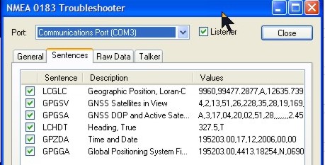
I’m sure I haven’t investigated deeply enough, but I’m mystified by Si-Tex’s eLoran, and maybe you can help. I got excited about the eLoran when first announced, then discouraged that, according to Si-Tex, it only works with their charting systems and P-Sea WindPlot software (primarily for commercial fishermen). Supposedly other companies could develop eLoran compatibility, but none have, as best I know. Then I actually plugged a borrowed eLoran into a laptop running Coastal Explorer and was a bit surprised to find it delivered both GPS and Loran heading information no problem, and might have given a Loran fix if CE was able to convert TD lines to Lat/Long. But maybe not, as that NMEA 0183 LCGLC Loran position sentence seen above may not be kosher.
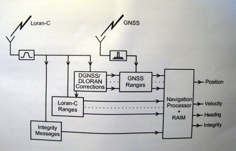
Then I plugged the eLoran into a Si-Tex ColorMax and while it gets a good GPS position, the Loran heading doesn’t seem to work. and I can’t tell if its getting Loran TD’s (the manual doesn’t even mention eLoran), let alone the sophisticated features like RAIM (Receiver Autonomous Integrity Monitoring) described in the eLoran manual (diagram below) . At any rate, I’m talking with Si-Tex technical support, but maybe some of you would check out the eLoran’s NMEA output. A log/text file is downloadable right here. Do those sentences make sense? Any chance you cab feed the data into a charting program or plotter, and see what happens?
PS Today I got a Franson GPSGate log file of eLoran NMEA for download here. While GPSGate is a terrific program, it will not play back this file; another mystery. But maybe someone can find a program that does?


Interesting that the UK’s Trinity House are experimenting with eLoran at the moment, and that it has been discussed as a part of the UK Governments eNavigation initiative, but that there are rumours that the USCG are going to shut theirs down!
Why eLoran? What need is it filling?
If we’re going to look for something to buttress GPS, why not a sat nav system that could use any combination of Galileo/GPS/GLONASS?
Some of the answers to the above questions are located at, http://www.navcen.uscg.gov/loran/Default.htm
Raul
Ben,
The NMEA $LCHDT String is coded correctly. However, the “LC” NMEA0183 Talker ID is probably the culprit. I’ve seen it before on a radar I was trying to interface a few months ago. The radar didn’t believe that a “Loran C” could or would compute heading. When I contacted the manufacturer of the radar, Furuno, they said they had never heard of the request before and said they would probably never modify their radar for it because of extremely low demand. I guess that most radars expect a HE or HC talker ID which is what normally comes from any kind of compass. Maybe SITEX even has the same problem within their own product line!
Additionally, the update rate is only 1HZ with this system. It is basically too slow for a radar and I’ve heard it is uselees for any autopilot which always want much faster updates. It is not a bad idea if someone could use it as a course monitor to check a magnetic or gyrocompass against it for possible errors.
Additionally, I’ve heard that the USCG has not funded LORAN in its budget for the past few years but, it gets funded by Congress at the last minute. Maybe someone could comment on this as I heard it second hand?? Generally, I haven’t heard of much interest in LORAN from any of the boats I’ve been on lately.