
Pocket Navigator SP, with a fab weather page
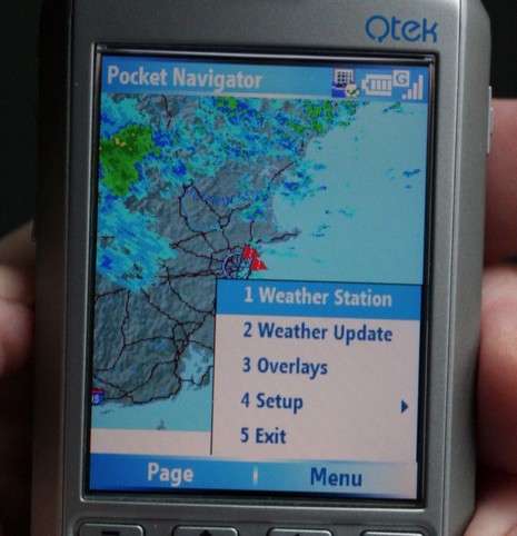
Yes, indeedy, that’s nearly real time Nexrad weather radar showing the rain around Boston this morning, and it was loaded automatically when I rotated to this page in the new Smart Phone edition of Pocket Navigator. This is not a subscription service; the software is simply using the phone’s web browsing ability to grab a small file from NOAA, and whereas the base map is resident a download covering New England only requires 2–10 k-bytes, depending on the amount of rain. On this particular phone and the Cingular service I’m trying, it takes a few seconds via GPRS and costs about a dime a download. Note that this is not animated radar—which was particularly noticeable today as the rain was moving east to west (very unusual here)—but at a dime a look, it’s easy to monitor the trends. The developer, Richard Stephens, also had set the phone up with several links to NOAA text weather predictions, buoy reports, and the like, which are similarly low bandwidth and work nicely.
This phone is also a pretty darn good micro chart plotter when used with a Bluetooth GPS, as illustrated in this larger photo. It even has a 1 gig mini SD card inside, so chart storage is not an issue! Of course the screen is even smaller than the PDA I’ve normally used this program on, and the touch screen is much missed (that’s why the menu choices above are numbered). But, then again, if you go everywhere with a smart phone in your pocket, how nice to be able to view charts, topo maps, weather radar, etc. Note that this version of Pocket Navigator is part of Memory Map Navigator 5.0.7, and is not yet included with the more stripped down version of Pocket Navigator that Maptech markets.
Update 5/4: Weather radar animation is planned for the next version of Pocket Navigator (PN) Smart Phone, and the Smart Phone implementation will be added to the Maptech version of PN soon. So what, then, does the the less expensive Maptech PN lack? The major Memory-Map advantages: a version of the PC program that is a full GPS navigation program, not just a chart and route manager; the ability to read lots of chart and map types besides Maptech’s; and, finally, more frequent and timely updates of PC, PDA, and SP programs.


Maybe I’m missing something here, where is the added value? I can access the weather radar web site at my local newspaper from my smartphone and get the radar and satellite pix already.
In fact it even gives me the data from three offshore NOAA buoys on the same weather site and thus I’ve got wind speed/direction, swell height/period and water temp (way too cold!).
Check out: http://www.sfgate.com/weather/
First, as Ben mentioned, it is much faster and more efficient, because only the radar overlay is downloaded with each update, not the base map image.
Second, you can scroll the radar image and zoom to several different levels. This is important to get the best view of the data on a small screen.
Third, your GPS location and other overlay data are displayed on the image. While you can eyeball you location on the web image, when you are out in the middle of nowhere, it helps to see your position in relation to the weather.
The NWS publishes a wealth of forecasts, buoy reports, forecast discussions, etc, formatted for use on a PDA or Phone web browser. I have used radar images on the regular browser for a couple of years, while dodging thunderstorms in the Great Lakes. I felt that a more specialized viewer was desirable, and this is it!
Richard.
Memory-Map, Inc.
With all due respect, when you’re out in the middle of nowhere on the water, there isn’t any weather radar or a cell phone connection.
Just what we need – another device to load charts onto, configure, figure out how it works, and debug. I supposed you need to connect this phone to another computer to load the charts? And what happens when I move to a different area? I then need to figure out which of the hundreds of chart numbers I need and which I can throw away?
When will all you computer people realize that there are only a few like you and a lot like me who just want to enjoy the water and not mess around with all kinds of configurations and memory cards and on and on…
Russ,
If you are in mid-ocean, this is not for you, but I think the majority of US boaters are within NWS radar coverage, and within cell-phone coverage. Low-bandwidth GPRS data communication works surprisingly well, even with a weak signal that would make voice unusable. A signal booster with antenna extends the range to about 50 miles.
And even inshore, there are many areas that are rather featureless on the radar maps, making it hard to judge your position. That’s why it makes sense to have the GPS location overlay.
SimpleBoater: all I can say is, I think this is one of the simpler products featured on Panbo. It is strange how mobile phones inspire strong passions: most people love them, some people hate them!
Richard.