
Ode to Panbots, far flung & obsessed
If a man must be obsessed by something, I suppose a boat is as good as anything, perhaps a bit better than most. — E. B. White
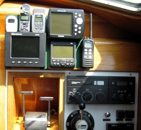
Some days I could be content just checking out the activities and links sent in by various Panbo readers. Who I like to call Panbots, somewhat in the spirit of Steve Roberts, the inimitable gizmologist with a knack for names. Yesterday Steve emailed notes on installing a Simrad AP20 (SimNet/N2K) autopilot he’s already dubbed “Tina” (as in Turner!). It went aboard his 44’ steel motor-sailor, the S/V Nomadness, which will have quite the systems when done. Steve’s blog has all the gory details, including a run down on the temporary electronics set up above (and the fuller White quote). You see he’s one of those frustrated folks waiting for a Furuno NavNet 3D delivery. {Meanwhile, a few of the Hull Truth posters who aren’t liking NN3D charts have gone around the bend into crazy conspiracy territory, even misinterpreting my entry on the subject; oy!, and more tomorrow.}
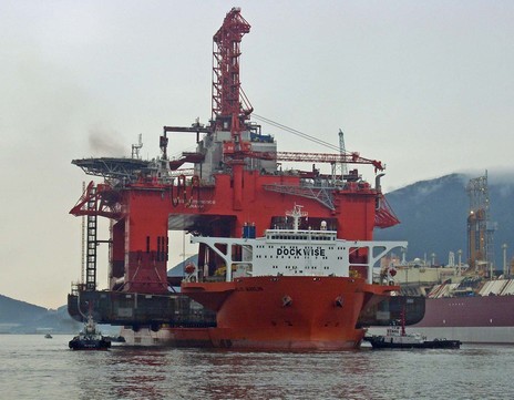
Then there were the photos Avery Brott emailed. Avery may be a homeboy, but I know that he sometimes checks out Panbo using sat comms from the offshore drilling ships on which he operates the DP (dynamic positioning) systems. Most recently he’s been minding the DP install as the mighty West Eminence was completed at Samsung’s Geoje shipyard in South Korea. Yesterday’s dramatic shot—below, and bigger here—show it loaded aboard Blue Marlin, bound for Brazil where it will seek oil in bottom almost 8,000’ deep. Imagine the major gizmology on that rig! If you’re as curious as I am about how Dockwise pulls off these moves, watch the “DOCKumentries” By the way, Avery enjoys operating a much smaller vessel when he’s home in Camden, and had some choice words for last week’s anonymous “Tonka Toy” poster. Big thanks to Steve and Avery, and Panbots everywhere.


Wow!
That AP100DL looks in mint condition. No small feat for a piece of electronics that is at least 21 years old.
Arnie… it will be going on eBay once fully extracted. <grin>
What is depressing, however, is the realization that someday all this shiny new stuff will also go on eBay… probably for the equivalent of a few cents on the dollar.
<sigh>
-Steve
OK, I’ll bite and feed the topic du jour. Think obsession.
I think I now understand the basis for the misunderstanding about the NN3D vector charts. Skipping the very large question of how the charts are presented, your perspective was that it’s the US government’s problem since they make the S57 charts. My perspective is that Navionics, Transas, and C-Map make vector charts from raster charts and the resultant charts are much better than the S57 charts we see in NN3D. My expectations were created by those vector charts. I don’t understand why state of the art electronics and software should be married to mediocre vector charts.
I could understand if these charts were the “free” charts and then I could purchase better. But it’s a closed system, I can’t purchase better.
However, it’s probably moot since I’ll be leaving the country in November. There won’t be any charts at all for Bermuda, so nothing to complain about there. And then it will be the MapMedia 3D charts for the rest of the world.
Russ, I know we’ve been through this before, offline, but for the sake of lurkers: what you’re looking at here in the States are MapMedia 3D charts. Here they’re based on NOAA rasters and S57 data; elsewhere they’ll be based on other H.O. rasters or S57 data derived from Navionics’ own vector format.
In short, I suggest that you don’t presume what the foreign 3D charts look like until you see them for yourself. Vector data can really look different from one presentation to another.
How true that is. I live in the Netherlands and just upgraded from Nobeltec 9 (Transas based) to Nobeltec 10 (C-MAP MAX PRO based). Boy, what a difference.
Most of it a VERY definite improvement, some of it not so good. I’ll need another weekend on the boat to figure out how to possibly overcome the ‘worse’ bits.
As Ben states, both sets of data come from the same source (in this case the Dutch Hydrographic office of the Navy). What they do with it is very different.