
NV-Charts on Navico displays, another ‘paper’ option!
The surprising press release just came in this morning. I didn’t even know that Navico multifunction displays could handle “raster” style digital charts — the ones that look like paper charts — let alone that NV Charts was working to make its large portfolio of handsome cartography available to the owners of Lowrance HDS, Simrad NSE/NSO/NSS, and B&G Zeus MFDs…
You may recall that I reviewed NV paper chart book kits last summer, along with the included CD files that can display in charting programs like Coastal Explorer. I really like the design and detail that NV brings to their charts, and I like rasterized NOAA charts too. They may be a lot “dumber” than a vector charts — they can’t scale elements as you zoom or keep soundings numbers and label text right side up if you go to “head up” mode — but then again a vector chart is finally “drawn” by algorythms, not the original cartographer, and I’ve seen many instances where that process is imperfect.
But the display of raster charts on MFDs has been rare, probably because they are large files to store and process. The high-end Furuno NavNet 3D series can do it quite well, even showing rasters contoured and 3D (which may look odd in screen shots but often works well for me), and Jeppesen C-Map 4D has included a NOAA raster layer for some time, but 4D isn’t supported on major MFDs (Standard Horizon CPN excepted) and neither MapMedia (Furuno) nor C-Map seem to offer raster coverage as wide as NV’s anyway. It will be interesting to see how well these NV Charts run on the various Navico MFDs and apparently they are available for sale right now, even if not yet listed at NV-Charts.com. If you try them (as I hope to), please share your experience…
And hat’s off to Navico, by the way, for offering their users more chart choices. Current Lowrance and Simrad displays can already display various Navionics cartography packages up to Platinum+ as well as Navico’s own Insight HD charts (getting better all the time, though U.S. only), and I even tried inexpensive FlyToMap vector charts on the NSS last summer (they needed more work). Actually, I like to have multiple chart types available if not on screen together, and I’ll close with some illustrative screens from the Furuno TZT14 that installed at the end of Gizmo’s fall cruise…
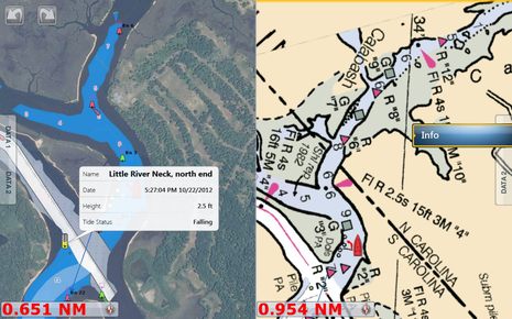
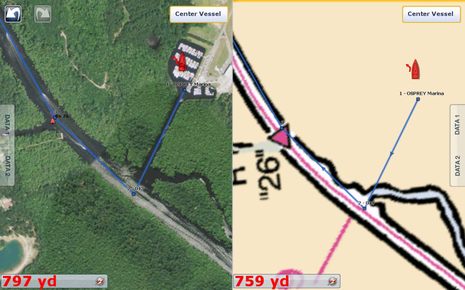
I liked running the ICW with both vector and raster charts side-by-side, and with MapMedia’s hi-res photo mapping usually overlaid on one or the other. Maybe it’s my age but I find that NOAA raster at right above quite informative. Perhaps it’s knowing that a human decided what to emphasize? I also like how a raster charts, designed as they were for print, always reveal the scale of data the cartographer felt able to use. For instance, when you “over zoom” on a bit of waterway, as seen below, that big “26” is telling you be careful about presumed accuracy. Note, though, how any chart can miss a significant feature like Gizmo’s current marina, though it shows up great in the satellite photo. I wonder if NV Charts will be able to display with photo maps and vectors on Navico display, but even if they can’t it’s good news that they’re on MFDs at all.


🙂
1 step closer to weekly SOLAS (BaZ) chartupdates for our sandy Waddensea
Thanks to reader Erik, I now realize that Navico has been encouraging third party chart creation for a while (rasters included):
http://tinyurl.com/simrad-cartography-toolkit
And apparently Navico plans to release a consumer version of the cartography toolkit for personal chart creation, though it’s been delayed quite a while.
Perhaps worth of mentioning that on the side of PC based solutions OpenCPN works with both raster and vector charts. There is a plug-in for NV-Charts on Windows systems at hand as well.
Some information that I received from NV in Germany:
– Charts will be sold on SD or micro SD cards to fit into Navico plotters
– Coverage will include all of NV’s own cartography, that is, all chart sets that are sold as “combi-packs” (paper + digital bundles)
– Any area not available as combi-pack (i.e., digital-only) is not NV’s own cartography and will not be available for Navico plotters
– The areas will be “bundled” (I read this to mean Navico chart modules will not exactly match the existing areas but will combine areas)
– They will be priced independently; there will be no bundles or combinations with their existing products. The reason being that NV is charged by Navico for each module sold
I think this an interesting product for anyone with a Navico plotter in an area covered by NV’s own cartography (which includes the Caribbean, the Bahamas and the US east coast).
I like raster charts and can attest to the NV products *that they make themselves*.
Steve Rowlandson has a very different experience with an area that they don’t do themselves so everyone please be aware of the important difference between “combi-pack” and digital-only.
It will be less interesting for anyone owning their paper charts and/or also using PC navigation because of the double charge.
It does not help anyone in an area that NV does not cover with their own cartography, including Steve and (partly) me on our upcoming trip to the Canaries as the Netherlands, the English channel, the French atlantic coast, Spain’s atlantic coast and Portugal are all not covered by combi-packs and in any case, I doubt that I would be willing to pay double for all these areas, some of which we might only spend a week in.
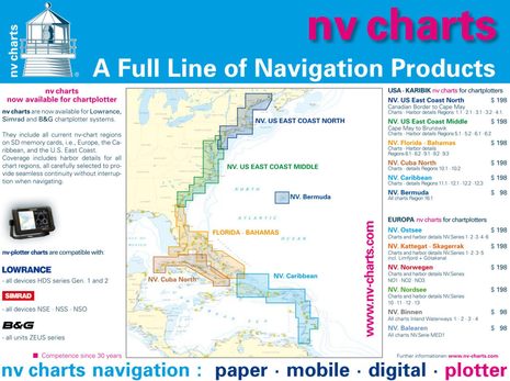
Thanks, Henning; that sounds like good advice. Note that the NV Charts graphic above shows the US and “Europa” Navico chart bundles (more readable if you click on the image for higher res version). They are much larger than the combi-packs, at least for the US sections I know.
The graphic, by the way, is from the NV PDF press release about the Navico charts, which I don’t yet see on their site or elsewhere online. Anyone?
I tipped Stentec (WinGPS) about this.
They seem to be interested, and contacted Navico for the toolkit information.
WinGPS uses the weekly BaZ to update their charts
I had indeed overlooked the prices and regions in the press release.
For “Europa”, the price for all 6 Baltic regions minus German sales tax is EUR 317/USD 425 (there are no prices for these regions quoted in USD).
So the Navico chip is just under half of that for the same area. You don’t get the paper prints but NV must cover license cost for Navico so that’s probably reasonable.
As an aside on paper and digital bundles in general: as much as I like them, anyone planning a longer trip will soon realize that it is not just about cost. My guess is that NV’s entire chart portfolio in paper stacked up will be over 5 inches high and approaching 10. How much does that weigh and where do you put it on a 45′ boat (that ARC’s average boat size)? I wonder how many of those that declare everyone irresponsible who does not carry a full set of paper charts would actually load their boats with 125 pounds of paper? And that paper has a shelf life of no more than a year. According to all paper chart dealers, it is most irresponsible to not buy a fresh set each year – and they may be right. So for an Atlantic circuit I couldn’t buy all the paper charts when leaving home because otherwise I would have to dispose of half of them unused mid-way through the voyage. I guess I would have to line up a string of visitors, each bringing in fresh charts and carrying off old ones. Or could I correct them? I don’t think so as I asked a friend to do this once on my charts in exchange for his time aboard and he managed less than half an inch before quitting, saying that he likes my friendship but not at this cost.
Put my hands on them(NV charts on Simrad and Lowrance) at Boot Dusseldorf.
Looking good and speed is okay.
NV is planning to widen the area with the Northsea this year or next year.
They intend to do a montly chart update according changes give by Dutch BaZ and German BSH.
Hendrik, that would be cool — weekly RELIABLE BaZ updates! I like Navionics’ fresh data but there is no telling what they have applied to our local waters.
What system are you using with the NV raster charts? Simrad NSE maybe? Have you ever used the Furuno NavNet 3D in raster chart mode to be able to make a comparison? Thanks.
Quitsa,
Comparance between Windows Xplore IX104 and Simrad NSE/NSS.
Never touched a Furuno Navnet 3D
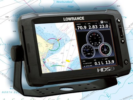
Thanks. Good to hear positive comment on the NV charts for Simrad. I need to outfit a new boat this spring and was leaning to the NSE displays because of their CHIRP sounder technology. I have a NavNet 3D system now and much prefer the raster charts (somewhat like Ben’s comments in the article).
I first saw this news elsewhere, and was disappointed to not find ANY mention of it on their website. I cannot imagine going to the trouble of creating a press release to drive potential buyers to a website with no information???
That aside, I wonder how their Bahamas coverage compares to the explorer charts? Does anyone know? The explorer charts are the known gold standard for the region, but are only available on Garmin products. We have an NSS7, so we only use the paper explorer charts in the Bahamas, and treat the Simrad charts as only a base map. It would be wonderful to get explorer quality on the NSS.
Hey Chris, NV has updated their site to show the costs and regions for their SD charts. Also, regarding the Explorer charts, which I agree are the only true reliable option for the Bahamas, they have been available for Furuno’s NN3D/TZT and MaxSea/Nobeltec for quite some time, as well as their high resolution satellite photos, which are absolutely amazing. I wasn’t even aware that Garmin offered a raster set of Explorer charts, just their G2 Bluechart. However, go to http://www.nobeltec.com and view some of the Odyssey screenshots or watch the video clip to see how the Explorer charts came out when rendered in their .MM3D format.
These NV raster charts are still in the “vaporware” category. I called the US distributor today and was told they are not available yet and they don’t know when they will be coming. “The announcement was premature” was the comment.
Our apologies for any disappointments caused. The first products are shipped to the us right now. This includes Bahamas, Florida and Caribbean. The others will follow asap! Our website is undergoing a refit as well. Thanks for your honest feedback!
Jeppe, NV CHARTS – Newport
picture of packing
By the end of this month (May) you should see the cards for the USA start to roll out.
Chris Meyer
Lowrance Dealer Service
Jeppe — I had two questions that could not be answered when I called. I am sure these are matters of broad interest.
— what is your return policy? There is no realistic way to check the look and feel of the NV charts on my Simrad NSE or the speed of redraw without buying a card and trying it. I hate to spend $200 on something that proves unsatisfactory. Tired of being manufacturers’ test bed!
— do you plan to sell bundles of the chart cards with the paper region books at a discounted package price?
Thanks.
Here is a sample file that all are welcome to try.
It includes a sample around Nantucket and Bahamas
Just copy the content on an SD/micro SD card.
(it needs to be FAT32 formatted, which usually is the case)
http://85.214.112.207/ftp/nv/sd_card_master/sd_card_sampleUS.zip
Of course you can also return the product if you are unsatisfied.
Jeppe – NV Charts
Thanks, Jeppe, I was hoping you’d make those samples available.
I don’t think anyone will be disappointed, though. I just tried the sample charts on both NSS-8 and NSE-12 with radar, StructureScan, and lots of N2K going on. The NV charts pan, zoom, change scales and quilt very quickly and they look good.
But anyone who tries NV should understand that they are treated by Navico just like their own Insight charts and that you need to Chart Options/Imagery to “Shaded Relief” for them to show (I have no idea why).
SD / microSD cards are available in our Newport office and ready for shipping.
http://us.nvcharts.com/index.php?page=categorie&cat=25
With kind regards Jeppe Scheidt, nv charts
Thanks guys for the conversion, I personally am quite used to Raster Charts and need them, Simrad NSS 7 Evo 2, I need Mid Atlantic Nj thru VA USA fo my travels to 200 miles offshore, Tnx, please let me know
Tnx Bob