
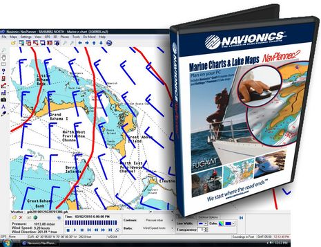
Navionics NavPlanner2, from Fugawi
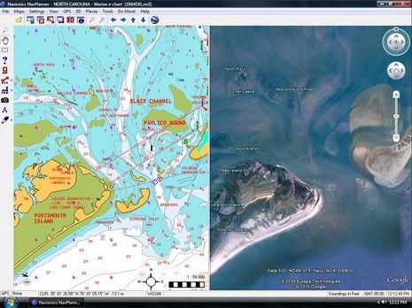
I’ve always liked the idea of route planning software, but Navionics NavPlanner was somewhat troubled from the start. Hence it seems like great news that Navionics dumped it entirely in favor of a partnership with Fugawi, leading to this recent joint announcement of NavPlanner2. Fugawi figured out how to present Navionics data well years ago, and then went on to produce the excellent Navionics HotMaps Explorer. Judging from the NavPlanner2 screen shot above — which shows off Google Earth synchronization — it shares a lot of code with the HotMaps lake planner. But NavPlanner2 has many added features…
For one thing, the $129 NavPlanner2 comes on a DVD with Navionics Gold charts of the entire U.S. plus the Northern Bahamas, and a card reader that can access all data on any current Navionics format card you may already own. In fact, my experience with Fugawi ENC suggests that this new software may give better access to all the extras on a Platinum or Platinum + card than your plotter does. Plus it has place name searching and GRIB weather file overlay facilities. Plus, it includes even more U.S. freshwater data than HotMaps, with all of Navionics High Definition lake surveys (like my Lake Megunticook).
Now, you can’t navigate on this massive portfolio of charts and maps, but you sure could do a lot of planning on it. Then you can transfer routes to most any plotter via cable, card, or Internet. Note that I said any, because NavPlanner2 supports not only all the formats used by Navionics-based plotters but also GPX, KML, and others. And it can be used with Fugawi’s X-Traverse to transfer data online with iNavX or iMap on an iPhone or iPad, Facebook, and more. And all the transfers are two way, so you could conceivably use NavPlanner2 to collect and enjoy tracks you made on all sorts of devices.
Fugawi has a good run down on NavPlanner2 here, but Navionics also has a downloadable user guide here (with detail on many plotter relationships). The only question I haven’t seen answered yet is the possible upgrade path for original NavPlanner owners who already have the Navionics card reader. I’ll ask, and also try the software when possible. It’s already shipping supposedly, and I hope other users will report in.


Ben,
I use Fugawi ENC (comes with a navionics card reader) and I used the Navionics charts for Bermuda this trip and found that moving around on the chart was quite quick.
I’d guess that the planner is just regular Fugawi with the GPS connection striped out, but of course if you have Fugawi ENC you don’t need the planner.
If, on the other hanad, you are one of those unfortunates with a dedicated chartplotter (at (often) many times the cost of a PC) I’d think it would be very useful.
Looks like now maybe late April for this.
I see it priced as low as $85 on google shopping
but with no supply that does not mean much.
This should be a good complement to simrad nse
for trip planning using the navionics gold
charts. I hope once loaded on your pc the
charts are usuable by coastal explorer.
Anyone know? Brian
“Can the included charts and maps be used in Fugawi Marine ENC for “real-time” navigation?
No. To use Navionics charts within Fugawi Marine ENC, you must purchase the charts on a Navionics Plug-and-Play chip.”
I think that is a NO.
That says for me I will use CE for trip planning with raster charts and upload routes to simrad directly. Brian
Brian, It wouldn’t make sense for Navionics to let people plot on all these charts and maps for so little money. Besides, CE is great at route planning and you already have alternate charts — Navico Insight, and maybe Navionics — on your Simrad.
If and when you get CE uploading to the NSE, please let us know. I’m pretty sure it will work fine, at least via GPX files and SD card, but would like to know for sure.
Also, I think that NavPlanner2 is shipping now, though it may have a ways to go through the distribution channels before it’s on shelves.
I saw your post – thanks for the heads up. It’s a dilemma for me.
Here’s an excerpt from my response post:
What I�d really like? A stripped down upgrade path:
* Let me use the software with my Navionics chip and card reader
* Leave out the cardreader
* Leave out the charts (I�m in Canada, and needed the chip regardless, then or now)
It’s worth a mention here that there is dandy free route planner available. Just download Polarview from Polarnavy.com and download free vector or raster charts from NOAA. The documentation is a little thin, but once figured out, it is very easy to bang out gpx route files to load on your chartplotter or hand held GPS. Polarview also does tides, currents, and GRIB weather data. (Canadian ENCs are a little harder to come by.)
All, Thanks for the interest. NavPlanner2 has started shipping to dealers. We believe all backorders should be shipped within a day or two. Regarding the Google shopping price mentioned above, please ensure you are comparing the price of NavPlanner2, not the original NavPlanner.
Thanks
Shaun
Navionics Inc.
Michael, I for one, do not consider myself unfortunate to have a dedicated chartplotter. I think that you’ll find they can actually cost less than a PC with a waterproof, sunlight readable monitor.
In any case, I’m with Ben; I like planning software. I currently use C-map charts along with theie PC Planner software. I take a laptop onboard and do all my route planning on it.
Raul,
How many chartplotters are really waterproof and sunlight-readable? I have been shipmate with several that were not, and were really unhappy in a (large) sailboat cockpit.
I am fortunate enough to have a pilothouse, so I don’t need a waterproof monitor, but an ordinary LCD monitor is bright enough for me.
No question, planning software is a good thing; it’s a great winter occupation to sit home working out the next year’s season — or even planning hypothetical dream cruises. No argument there.
Sorry to report that there is no upgrade path for people who already own NavPlanner and a Navionics card reader.
And @ Michael: Chart plotters have been on a fast development track; these days there are many that are truly waterproof and quite readable in tough conditions.
Perhaps someone could help me out here. I have a 52′ sportfish with dual-Northstar 958’s. One is used almost exclusively for a chartplotter, the other for a 1KW sounder/radar. They are redundant to each other should I need that.
I am interested in upgrading and want to consider a PC based system along with traditional systems such as Furuno, Garmin, etc.
Can someone give me some direction on a PC based system that will give me all of those capabilities? I don’t need just a plain vanilla chartplotter.
Thanks,
David
I use Fugawi ENC, I really like it, and it is great to be able to transfer data between it and my Northstar 6100’s using a card read and CF card. I just wish that Fugawi would let you use the graphical screen to string together your existing waypoints into a route, instead you have to do it by remembering the names and selecting them from a list, I have way to many to make that practical. If you do use the chart to create a route, it just creates a bunch of anonymous waypoints to make the route, and that never gives me the feeling of security when I see the name of a familar waypoint that I am steering to, knowing that in fact it is the correct waypoing.
Tried Navplanner2 on my PC (Vista x64) platform. Could not get the 3D to display for any of the lakes/coastal line that came on a DVD. All maps were flat on my screen.
Tried plugging pre-programmed Platinum+ card (area 901P+) as well as PREM-c6 to see some HD lakes in 3D – the same effect. The screen is flat. Can someone help please?
Hi Andy, I just installed Navplanner2 on my Vista x64 machine and the 3D stuff works fine on the DVD data. I haven’t tried a Platinum+ card yet.
As an owner of the first NavPlanner, I am quite happy to hear that there is an new version available. However, that said, I’m quite P.O’d that there is no reasonable upgrade path from my current buggy software to the new version.
As far as I’m concerned, I already paid a handsome fee and never got what I was promised. I would consider it only fair that they provide us with a fresh disk containing the software for FREE. I don’t need the special card reader – I have one. I don’t need the US charts on disk. I live and operate in Canada, on the West Coast of Vancouver Island.
Perhaps if they had spent less time and money copy-protecting the software with card-reader dongles, and serial numbers, and chart cards that can not be backed up – all under the threat that it won’t be replaced if you screw up and accidently overwrite the card, and put their time and energy into programming a solid piece of software, we wouldn’t be in this situation.
And now they want me to pay for it again, in the hopes that they got it right this time – I don’t think so.
Who do we write to to get our money back on the first purchase?
Jim, I fully agree with you. Bought Navplanner a couple of weeks before the new release. I’ve asked for an upgrade here at their Facebook page, may be you can leave a comment as well.
Is it possible to name waypoints through Navplanner? Or does it only use default numbering? Took a look at the users guide at the Navionics site, and it isn’t clear.
Liz, it is possible to edit NavPlanner2 waypoints to give them names. But waypoints can not be used in routes. Fugawi, and hence NavPlanner2, seems to differentiate between waypoints and route points.
Ben–thanks for pointing out that distinction! It’s the sort of thing that one (um, I) can consume hours on, trying to figure out why something isn’t working the way one (um, that would be me) imagines it should.
In any case, that matter is moot for me right now. Was trying to figure out what planner I should install that would be compatible with my new Win 7 system. Discovered that I still qualified for the free upgrade to ENC 4.5, which is admittedly overkill for my offseason fantasy planning purposes.
To clarify, waypoints CAN be used in routes. Simply open the Waypoint Library and the Route Library (From GPS|Waypoint Library and GPS|Route Library respectively). Double click on your route in the library to see all the route points. You can drag any waypoint or group of waypoints into a route, reorder points, delete points, etc. Enjoy.
Thanks, Fugawi. My bad!
Navplanner 2 is a huge disappointment. Loaded with shortcomings and pretty much useless, particularly for Lowrance Owners.
I was going to ask Windsor399 for more details about his disappointment, but, boy, did he provide them over on the Forum:
https://panbo.com/forum/2010/09/navplanner-2—an-honest-review.html
I just upgraded to a Hummingbird sonar and purchased the HotMaps premium. How do I go about using the charts on my PC? Please don’t tell me I have to dig back into my pocket to buy a software product to read the charts?
If this is the case this is #^&*ed up!
Moe, I’m a little surprised that you simple expect free PC support, but in fact Navionics is about the one chart card manufacturer that delivers it. Just download their Web store software and register your card and then you’ll have access to their PC chart viewer and also data updates for a year:
http://www.navionics.com/en/download-webstore
I wrote about testing the process here:
https://panbo.com/archives/2012/05/navionics_charts_really_fresh_data_lots_of_it.html