
Jeppesen NNS MAX Pro, it’s shipping!
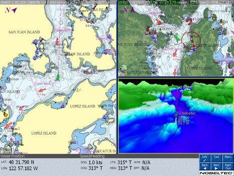
It’s been a while since Jeppesen bought C-Map, and even longer since the 9.0 version of NNS (Nobeltec Navigation Software) came out. But the new versions of VNS and Admiral are now shipping, and looking good too (big Admiral screen here). Of course, the major change is that the programs now support C-Map MAX Pro cartography, which is why they’re called MAX Pro and not version 10. Besides a world portfolio of some 30,000 charts—versus Passport’s 10,000–another bit of nice news is that everyone who currently owns NSS 9 gets a free upgrade to Max Pro, and a free MAX Pro chart region for every Passport region owned, and a free copy of the new Raster Plus Pack. (Owners of earlier NSS versions get various deals, depending, as explained in the press releases.)
What’s a Raster Plus Pack, you say? Well, this may come as a bit of bad news, but the regular versions of VNS and Admiral Max Pro will not read Maptech/BSB and NOSGeo rasters without the $50 Plus Pack (disregard the $300 price shown on Nobeltec’s site, it’s just a glitch as they revise everything). It was explained to me that the rationale for the extra charge is that installing third party raster charts causes a fair amount of customer service calls. Besides, MAX Pro may have the most paper-like look of any vector charts, as you can see somewhat in the screen shots (below bigger here). And what’s more it seems pretty obvious—given hints like its zero tolerance policy regarding C-Map and even Passport cartography issues—that Jeppesen is focusing on serious users. For instance, MAX Pro regions—which start at $339 for “Wide” areas like Eastport, ME to Newport, RI—will include a year of free Quick-Sync weekly chart updates, the Sailing Plus Pack now includes weather routing, and the Weather Plus Pack adds XM to Sirius, OCENS, and generic GRIB options. There’s lots more, and a good way to see what Jeppesen is up to is via the impressive 250–page VNS/Admiral manual downloadable here. I’ll be trying NSS MAX Pro soon myself, because it really is shipping 😉


It seems to me we’ve reached a crossroads. Do we buy two different sets of charts, one for a computer, and one for a plotter, or we do put all our faith in just one?
It’s pretty obvious you wouldn’t own NavNet 3D and use Jeppesen, you’d buy MaxSea and use the cross licensed charts.
What about Jeppesen with Raymarine G series? The G-Series comes with Navionics charts, so you’d need to buy two complete sets of charts.
What about Jeppesen and the Garmin line? As far as I can tell Garmin is a closed world, you only use BlueCharts. So again, if you want something on your computer, you buy two sets of charts.
So tell us Ben, how is this sorting out? Full function G-series, Furuno MFD or Garmin 5xxx plotter with radar and FF overlays, versus a laptop with Jeppesen? Jeppesen of course offers radar and other modules to interface to the computer, so is it the DIY of electronic navigation?
It’s good to have choices, but is it one or the other? Or can Jeppesen complement the major plotter vendors and give us some incremental functionality for the incremental expense of s/w and charts?
Thanks for this posting Ben .
I will not buy Furuno Navnet, since my rule is that everything must talk to a pc. That’s the main rule for putting a new box into my world. The laptop will always be the central box in my system.
Jeppesen is close to that rule….
What about Jeppesen radar / pc solution….
Is it as good as Furuno and Raymarine ?
It is much better then Raymarine or Furuno radar. If you compare specifications, Furuno and Raymarine are not as near capable as Nobeltec (Koden) radars. Nobeltec radars: MARPA for unlimited number of target, multicolor radar picture definition, off center display, radar overlay on any kind of chart type, double speed rotation, AIS targets both on radar and chart display, dual radar capability, etc. You fill find that specification only on very expensive Furuno models.
Ben, I remain a bit puzzled at Nobeltec’s moves here, as it has become increasingly obvious that the charts themselves are rapidly commoditizing in favor of free NOAA RCS and ECS and other “comes free with” bundling like we’re seeing with the new Furuno 3D. New reality: charts are now open source.
I agree that these new C-Map-inspired charts look a bit crisper, but not worth the hundreds of dollars to upgrade, and certainly not worth switching off V8 where I’d have to comply with Jeppesen’s silly new rules about which charts I can/cannot use.
I’d really like to see them put more resource into making the overall software more reliable instead of disaggregating the system in order to wring out more profit.
Drew, Don’t you think Jeppesen has brought some rigorous testing and process control to Nobeltec? Afterall, their core business is aviation navigation, a niche where mistakes and unreliabity really hurts! (I write this sitting in an airport bound for Palm Beach). Also, it’s only the basic charts that are becoming free and easy, and that’s true mainly in the U.S.; personally I like a lot of the value added stuff.
Bero, Are you aware of the new HD radar technology both Raymarine and Furuno have?
Lots more to discuss here, but I gotta go!
Bero have you been living in the 18th century and only just woke up
Koden radars better than Raymarine or Furuno !
Using radars at sea and installing them i would put Koden at the bottom of the pile.
Their “Dual Range” radar simply does one sweep on one range and another sweep on a different range very crude compared to the Furuno True Dual Range (both ranges swept at the same time) with NavNet 3D
Unlimited MARPA is the software not the koden radar the software simply tracks dots (watch MaxSea NavNet Timezero for this feature) the radar does not output TTM for use in other software / systems.
“Nobeltec radars: MARPA for unlimited number of target, multicolor radar picture definition, off center display, radar overlay on any kind of chart type, double speed rotation, AIS targets both on radar and chart display, dual radar capability, etc. You fill find that specification only on very expensive Furuno models.”
I believe you will find that on NavNet MaxSea currently let alone the new NavNet 3D and im sure Raymarine can do nearly all of that as well
P.S you can get that function from the cheapest navnet radar up to the top of the range navnet radar
So Bero please come out from your 18th century hidey hole and read the specs on new equipment that is being released!
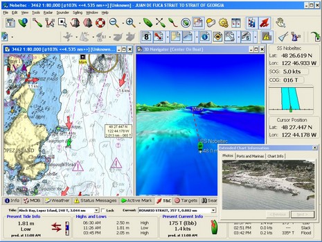
I’ve spent some time with Google Earth trying to recreate those two 3D views. The first exaggerates the height too much: Lopez Island is flat. The second is better, but neither can compare to Google Earth.
Further to Russ’s comment, Garmin keeps changing their own charts (…, g2, g2 Vision, …?) without even Garmin compatibility. The new top end chartplotters only take g2 Vision charts, even if you don’t want the 3D and other features/frills.
Also, I’m not pleased that my radar choice affects my chartplotter/charts choice and vice versa.
Ben,
What exactly HD is? Did anybody (Raymarine/Furuno) explained what they mean under “high definition”? Is it just a way to represent variations of reflected radar signals by colors and in higher resolution (read “Definition”) that is more appropriate for larger LCD displays, or we have “really” new technology here, something like SharpEye that Kelvin Hughes introduced recently? Personally, I think it is just a meter of nice marketing because I did not find any feature on new “HD” radars that you cannot already find on Nobeltec (Koden) or any other professional (IMO) radars on the market. Even “SharpEye” technology is invented years ago and used in military applications. Ben, let me know your opinion.
Rolf: When you suggest that NavNet won’t talk to your PC, what specifically does NavNet not do for you? Is this a historical problem or a problem with NN3D and MaxSea Time Zero?
SharpEye replaces the magnetron (a specialized vacuum tube) with solid-state electronics. One of the effects of this is lower power pulses, therefore I think all of the new HD and UHD radars still use magnetrons. I’ll post some links in the SharpEye entry.
ALL current radars are analogue front ends (TX side)
Most radars (Koden, Non HD Furuno, Non HD Raymarine) use an analogue read end (RX side)
The new HD radars use digital backend processing so enhance the picture that way.
P.S Bero, was on seatrials today Furuno FAR2117 v MDC-1910P Koden
Both good radars but it would appear the Furuno beam width and pulse length are finer also including a more sensitive receiver on the Furuno v the Koden.
I don’t understand what the big deal is about C-Map Max Pro. These are S-57 format charts. Is Nobeltec now charging us what we used to get for free from the US Government? How is Nobeltec’s quality better than the US Government’s?
NOAA ENCs (aka S-57) are great, potentially, but the last I heard, only about 60-70% of the NOAA portfolio had been converted. I think the coverage has holes most everywhere, and doubt anyone is navigating exclusively on ENCs.
Outside the U.S., there’s only one or two other countries that give away S-57 charts, I think. And then there’s all the goodies C-Map (and others) add in…photos, POIs, bathy, etc. That’s the deal.
Warning—
After reading this I ordered the upgrade from version 9. The new software requires a DONGLE (hardware key) which the old version didn’t require. After trying to install and spending hours on the phone with tech support (good, but no solution) I still can’t get my Thinkpad laptop to recognize the fact that the dongle is installed.
I understand protecting their intellectual property, but I may move to a product without a dongle. It’s just another thing to go wrong, and as we increasingly depend on the software for AIS and Navigation data, I don’t want more complexity.
Keep your version 9 disks handy, you may need to reinstall if your machine doesn’t recognize the dongle!!
Dan
Bummer, Dan! And surprising to me. I’ve used several dongles, including Nobeltec’s 8/9 model, with no problem. In fact, experience has led me to prefer dongles over software copy protection.
But I haven’t tried installing Admiral MaxPro yet; will do later this week.
OK, so I backed out the MAX upgrade and have reverted to version 9. I have to say that I’m pretty unhappy with Nobeltec since the 9.3.2240 upgrade removes the S57 chart support, and the Max upgrade removes the Raster chart support and makes you buy a separate upgrade for raster support. So if you bought the earlier version because it had both S57, Raster and Passport support Nobeltec has basically screwed you. I can’t support a product that removes features in the “upgrade” then charges you to get them back. I advise anyone to avoid purchasing Nobeltec and look at other products. I think I’m going to move to Fugawi !!!
I’m curious what you think Ben.
Well, Dan, I think some Nobeltec users will express the same objections you have in much less polite terms! But that others won’t give a hoot as long as Max Pro cartography is anywhere near as good as advertised.
Personally I’m a bit NavNet 3D obsessed right now, and think Furuno/MaxSea’s decision to back raster and S57 formats is possibly wise, if bold. I hope it will raise the profile of these resources and help motivate NOAA to finish the U.S. S57 portfolio, and other HOs to get with the program. But it’s also NN3D’s biggest weakness, I think, and will discuss soon.
Damn dongle! I shouldn’t have said how easy they’ve been in the past.
I had the same problem you did, Dan—VNS/Admiral just wouldn’t see the dongle—except now tech support recognizes it as a known issue. They had me delete some odd Programs/Common/InstallShield folders, then uninstall all of NNSS MaxPro right down to running RegEdit to delete the Nobeltec entry.
Then I reinstalled everything, and, by gum, it worked. But now I can’t get MaxPro charts to install without causing a crash. I shut down for tonight, a little exasperated.
At any rate, the tech said the dongle issue is moving up to “level 3”, and there should be a note and maybe software fix at Nobeltec soon. But the smart kids will delay upgrading until some of these bugs are squashed.
An update on the upgrade: with the MaxPro editor’s package was a bright yellow piece of paper containing special instructions about how to install the MaxPro world portfolio. Which I failed to notice. So that issue is on me!
Note to lurkers: Dan and I both had the dongle problem because apparently we both belong to a relatively small “subset of customers who have previously installed something on their computers that uses an Install Shield installation script”.
Nobeltec is definitely working on the problem, and knows how to fix it if it’s already occurred. It would be much easier, though, to delete the problem folders before you do the install.
Knowing what I know now (never, of course, the whole picture), I’d see if there was a Programs/Common/InstallShield folder on my machine, and, if so, call tech support before starting the install.
Late addition to this theme but feel I must add a warning to any one in Europe planning the “free” upgrade to MAX Pro. If you upgrade you will lose ALL use of currents outside the USA. Nobeltec are aware of this issue but don’t appear remotely inclined to fix (Over 6 months now). To compound this, European users had dongles for earlier versions of VNS/Admiral and your dongle is killed as part of the upgrade process = no reverting to previous version.
You upgrade to MAX and effectively you don’t get what you paid for when you purchased VNS or Admiral. This is real pity as I am otherwise impressed with my Nobeltec/radar combo.