
Navionics Boating app AIS feature, great idea but…
Well, dang, I was steeled up to write an unusually negative entry about the AIS feature that Navionics recently added to its Boating app, but then I learned that they’re already planning virtually all the improvements that I intended to vigorously champion. So, if you too are having trouble making the WiFi connection work — or if you too are disappointed with the resulting target display — don’t worry; apparently, we just have to wait for future versions.
In the meantime, however, let’s discuss how boat data over WiFi can and should work, and also what makes AIS target display actually useful when you’re underway.
AIS data via WiFi
First of all, congratulations to Navionics for deciding to support AIS data coming from a boat’s own receiver instead of using possibly spotty and/or delayed AIS info from the internet (even though the latter is easier to do on a mobile device that’s likely online much of the time, and is also desirable as a secondary source).
Moreover, while the Navionics AIS feature announcement only mentions AIS receivers with WiFi built-in, their PDF list of compatible devices also includes many Navico multifunction displays (possible because of GoFree Tier One 0183) and numerous NMEA-boat-data-to-WiFi gateways. Plus the Navionics app tries to make the connection automatically, which sounded great until it hardly worked with any of Gizmo’s many WiFi AIS sources.

This is an extreme example but it illustrates at least part of the problem. While WiFi connected to Gizmo’s boat router, version 14.1 of the Boating app running on my iPad automatically connected to three AIS data sources but couldn’t reliably receive data from any. Yes, the source identified as a “Digital Yacht WLN10” (though I don’t have that device installed) did deliver some AIS info as well as the Sonar (depth) and GPS that the app can also use, but not well. In reality, there were about twice the AIS targets you can see (faintly) overlaid on the chart and meanwhile the Sonar and External GPS data feeds were fidgeting on and off, which is why they seem conflicted in the screenshot.
It’s not surprising that the Navionics app chokes up while trying to digest multiple sources, but it’s discouraging when I can use other apps running on the same iPad to successfully choose whichever of those same data sources I want to use. Moreover, even with an easier single-source situation like a direct connection to a new Actisense W2K-1 WiFi gateway (I’m testing) Boating v14.1 failed to even find the AIS, GPS, and depth data that other apps can display fidget free.
So while trying to make the data connections automatic is a worthy goal — and is working for some boaters as reported in this recent Panbo discussion — I began hoping that Navionics would also let us set up the connection the way other developers do.
Hurray then that “in the next few releases” of the Navionics Boating app there will eventually appear a “Custom device configuration”… whereby “There will be a way within the App to enter IP address and Port Number to connect to virtually any device streaming AIS, GPS, Sonar data via WiFi and NMEA 0183.”
I’ll illustrate what that means below, but first let’s look at how Navionics Boating v14.1 displays AIS targets and where that’s headed.
AIS data display
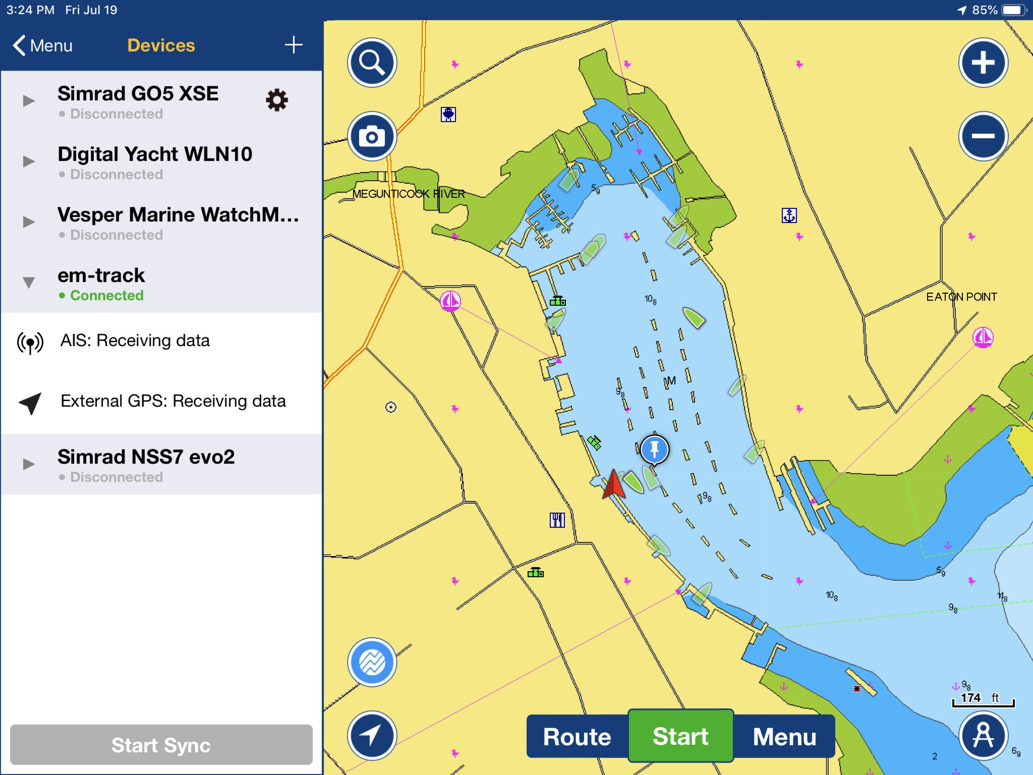
In this example, Boating v14.1 is connected directly to the WiFi access point created by a Si-Tex MDA-5 AIS transceiver (a SOTMA type Class B+ that I’m finding to be quite able and fairly priced). Nevermind that Boating identifies it as an “em-track” (another issue with auto-discovery) and nevermind that I seem to be on a dock instead of Gizmo’s nearby float (the cause may be my install of Si-Tex’s external GPS antenna, not fidgety data reception). But please do click the screenshot larger to better see the display of AIS target info, which seemed to be delivered consistently.
While Navionics uses transparency to de-emphasize vessels that aren’t moving — nice, I think — the four underway AIS boats plotted in Camden Harbor at this time don’t seem sufficiently obvious in this presentation. The colors are quite similar but mostly I miss the COG/SOG vector line that’s common to nearly every other AIS target display I’ve used.
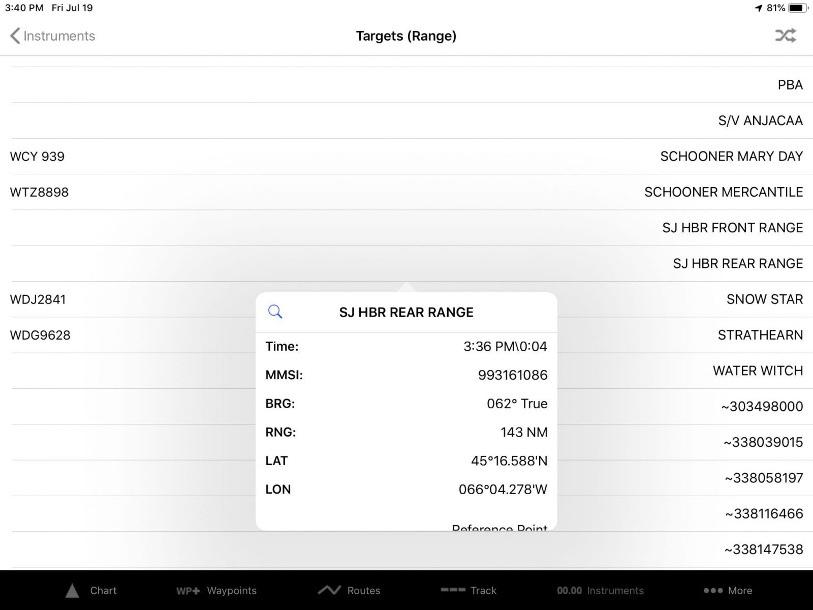
Moreover, and again this is an extreme example, I was quite surprised to look up and realize that the underway vessel plotted as alongside Gizmo was not actually there or anywhere close. Now it’s common to see differences between plotted and real AIS vessel positions — the typical Class B dynamic data transmission rate of 30 seconds is one cause (that Class B/SO can improve on). But this seemed to be a case where maybe the vessel had been alongside at some point prior and then turned off its AIS before docking somewhere out of sight. AIS displays usually mark a target that has not been seen for a while, or you can dig into the detailed target info when in doubt.
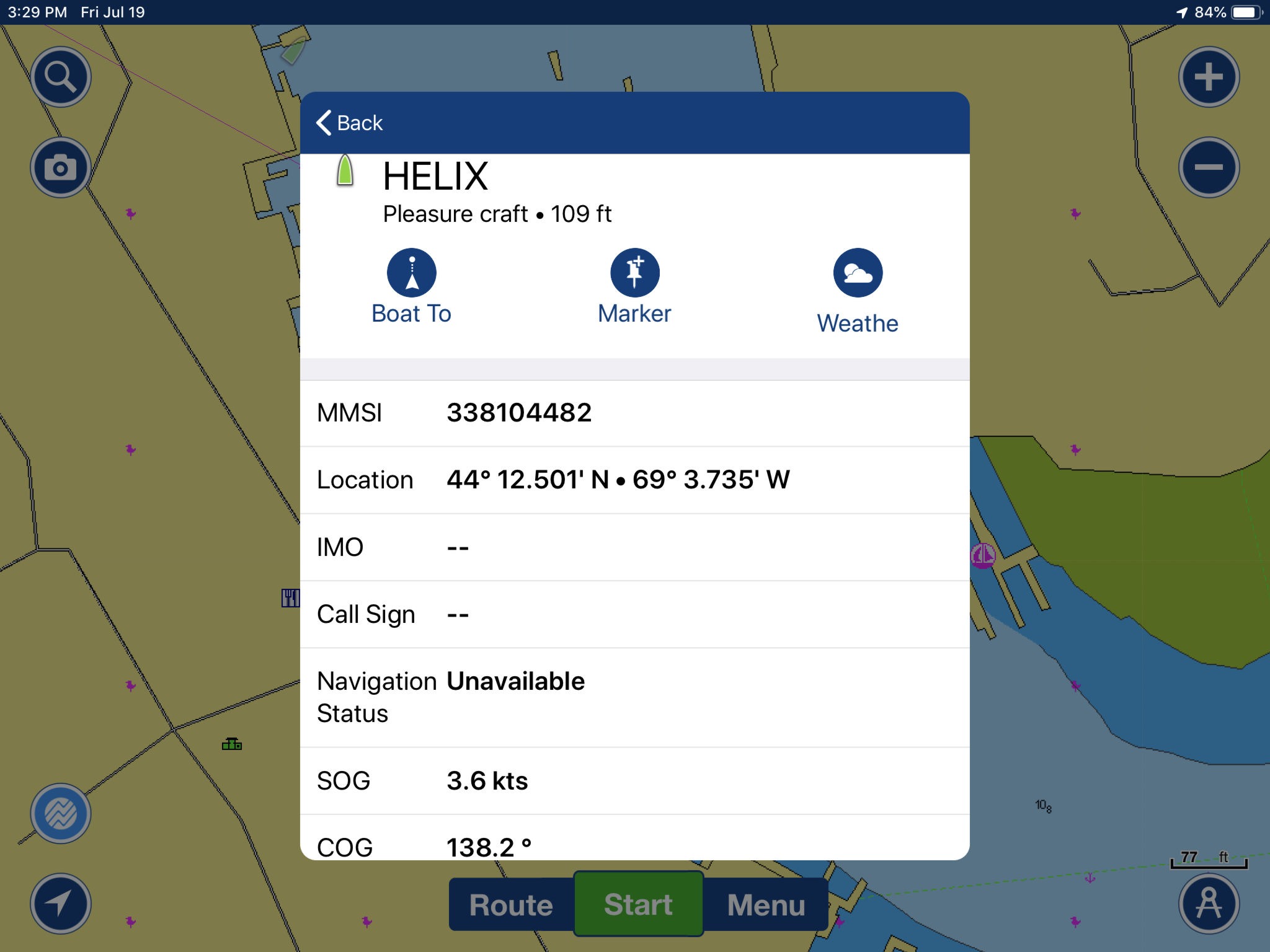
But a Boating v14.1 individual AIS target info window does not include a timestamp, which to me is like a tech review without a date. Also not included is the size of the vessel — Helix is not 109 ft long, but was that close to Gizmo supposedly — and the type of AIS in use, all of which is included in the Si-Tex data stream. What’s not included for Class B vessels are items like IMO number and Navigation Status, which is why those uninformative lines above are filtered out of most Class B info windows.
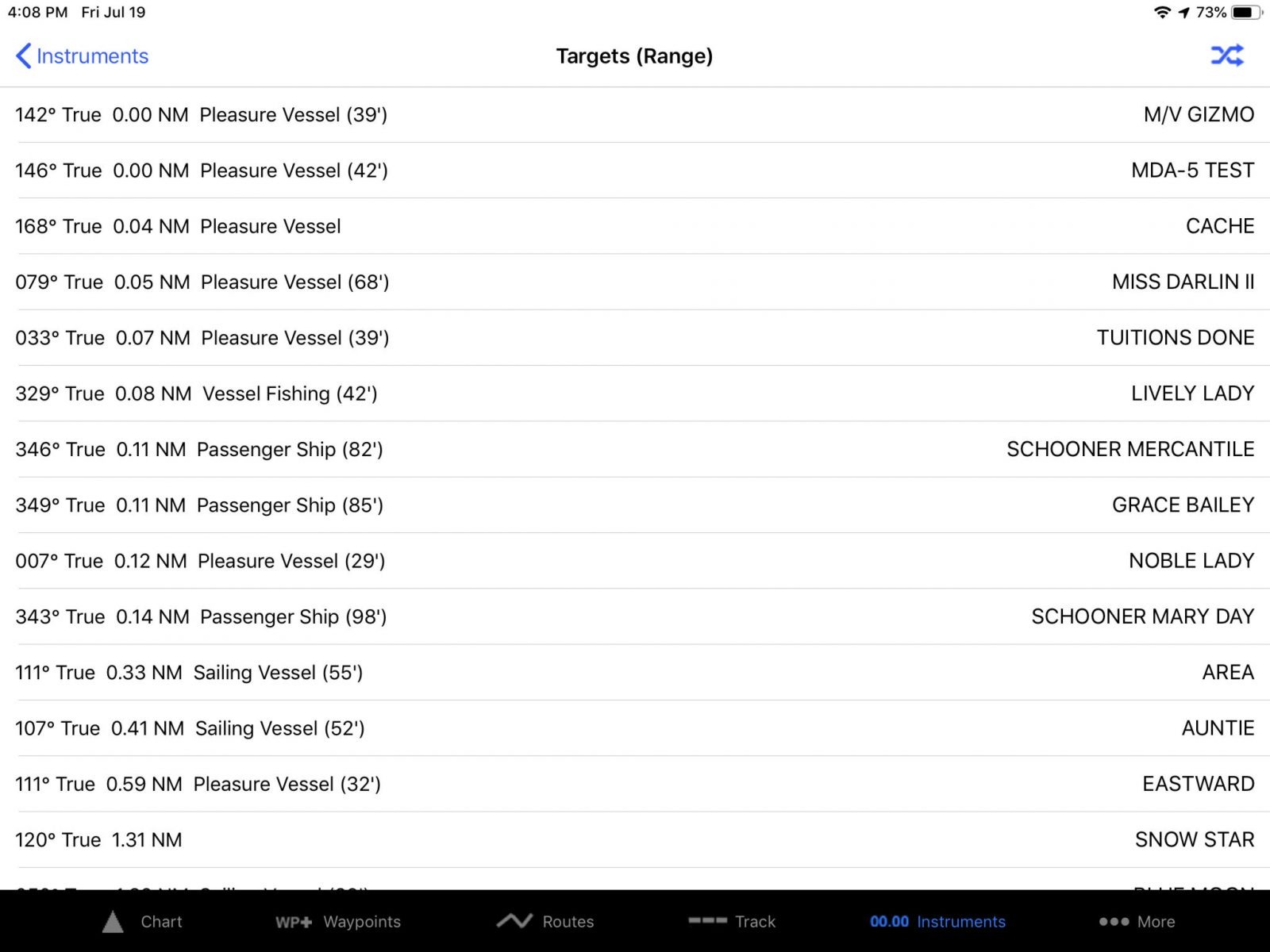
Also missing from Boating v14.1 are calculations for Closest Point of Approach (CPA) and Time of (TCPA), along with a sortable list of current targets. And these are critical items if and when you seriously use AIS as an aid to collision avoidance.
But, yes, I am indeed picking on the first version of a worthy feature. However, that’s because Navionics Boating is already a terrific boating app in my opinion, and this expanded WiFi data feature could take it to the nav tool level of good apps like iNavX, iSailor, SEAiq, and TZ iBoat. Moreover, I fear that some boaters have not developed a critical eye for effective AIS target display, so maybe my rant is helpful that way.
The best AIS target display I’m familiar with is still Vesper’s WatchMate app, but it requires particular Vesper AIS devices. Hurray then that the Navionics Boating app WiFi AIS feature will eventually include:
- Display of ROT, COG, SOG and Heading on each target.
- Anti-Collision.
- AIS targets search.
- Targets on the map will reflect proportionally the actual size of each vessel.
iNavX doing WiFi AIS data right
While we’re at it, let’s look at how some other apps have been handling WiFi AIS data for some time, and iNavX is a worthy example as it trail blazed this feature before Panbo even had an iPad. The iNavX v5.5.6 screen above came from the same iPad and Si-Tex WiFi AIS as the Navionics examples.
Note that I’ve set the highly valuable underway target vectors to represent two minutes at current Speed over Ground (SOG), my preference in coastal waters, and that this setting in iNavX is the same as your own vessel vector (in other apps and on MFDs these are often separate settings). Note too that one of the many AIS display settings you can see in the gallery below is the ability to show / not show target boat names, a setting I use enough that I wish the switch was right on the chart screen.

iNavX WiFi data link setup shows NMEA 0183 data stream when working Some iNavX AIS target display controls (speed vector length elsewhere) iNavX showing AIS targets sorted by range (CPA and boat name also possible) iNavX target details include a timestamp and most everything else possible
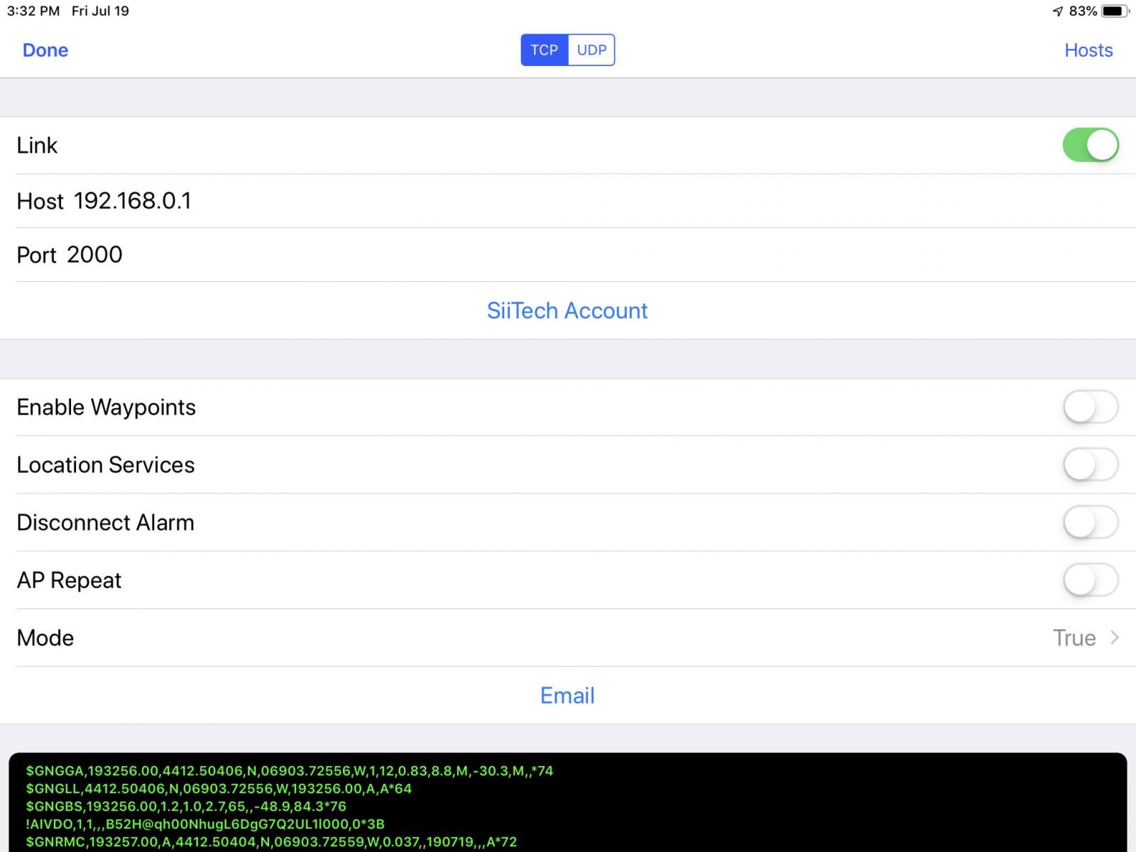

The top left screen above shows how iNavX handles the WiFi device IP address setup that Navionics has tried to protect users from but will add as a secondary connection method. It does indeed look frighteningly geeky. How the heck, for instance, did boating come to involve the difference between TCP and UDP, and how do you find those numbers on the source device anyway?
Well, I’m not an IT person either, but I have learned enough about IP addresses to do this sort of setup many times, and once done it tends to work well. Note too that if the connection is made, you’ll know it immediately from the stream of NMEA 0183 messages scrolling in that lower window, which is common to many apps and also great for data troubleshooting if needed.
The other screens show more iNavX AIS display settings — but please don’t filter out Class B targets — as well as their sortable target lists and an individual target screen with the precise timestamp right at the top (harumph).
I’ll close with the fact that the Navionics Boating development team was already monitoring Panbo comments about the WiFi AIS feature when I contacted them. And hopefully that’s extra incentive to share your thoughts about how this excellent boating app should evolve.


PS The WiFi AIS feature is only available in the Navionics Boating app if you have a current subscription, which I think fair.
But receiving GPS and Depth over WiFi does not require a subscription, presumably because that data is needed to collect SonarChart data which benefits Navionics (and the rest of us).
This is great stuff. I do hope that Internet ais data also becomes an option for those who don’t have receivers. Anything that increases safety is a good thing. My issue is that I use my iPad with a raymarine wi-fish fish finder for sonar charts. That also on WiFi, so I cannot connect to the sonar chart device and the ais one at the same time. I wonder if there are Bluetooth ais receivers and navionics would allow that type of connection.
It is a dramatic feature what navionics implements.
We tested it and it is in one word; unsafe app.
We tested against opencpn with random transponders and receivers. It seems that several AIS targets are not shown or even disappear from the screen. far away and nearby.
We are convinced that it is a real Béta version and is really not grown up for publishing!
What fails:
– No AIS target list
– No CPA from target
– No TCPA from target
– very weak AIS symbols
– No UDP network connection possible
– No AIS target vectors
– No AIS target tracks possible
When connecting with a Ipad, we could not change to UDP and all other devices where disconnected.
Unbelievable in this AIS era.
Thanks, Tom. I too wish that Navionics had held off with the AIS feature until it was more completely developed, but their improvement plans sound good. Also, I think it’s great that the most popular boating app — their claim, but I don’t doubt it — has introduced a wider audience to this “dramatic feature.”
I certainly agree that it doesn’t appear Navionics’ AIS functionality is ready for prime time. But, in some communications with Navionics, they mentioned they like to get features out as they’re completed and not hold them back. I think this time around they might not have struck the right balance but I do applaud them for being aggressive about getting new features out.
Yesterday I set up one of the three data servers available on the Actisense W2K-1 as UDP with the port address 2000 and Navionics Boating immediately connected to the AIS, Depth, and GPS data the W2K-1 is getting from Gizmo’s NMEA 2000 network. (The latter two values seem fidgety but maybe I should try it underway; and the Actisense bridge is misidentified as a “Digital Yacht WLN10”.)
At any rate, I don’t know how Boating’s auto-discovery works, but it seems to like port 2000 (if you have source that can be customized).
I totally agree that the new AIS feature is useless and unsafe. Wonder why the navionics people haven’t tried out the competitors features before spending time on developing the AIS function ?
Normally I prefer to use Navionics on my Ipad as a backup to my Raymarine plotter, but when I need the AIS function here in the Mediterranian I turn to InavX. And I will probably keep on doing this for a while….
SeaIQ can take AIS data from WiFi and cellular internet simultaneously – and has the good sense to show the two sources in different colors.
Hi Ben,
It is good news that Navionics is finally starting to move in the right direction and catching up with features that are standard in any good navigation program. OpenCPN has supported AIS\NMEA\TCP/IP for years. And, as you point out, iNavX has been doing NMEA over TCP/IP the right way for a very long time. I wish Navionics would learn from programs like OpenCPN how a charting application should work. Navionics is an average app at best. The only reason I use it (as a backup) is because of the reasonable price for world-wide charts. There are so many flaws in the program; for example, not allowing one to delete a single chart area without deleting all charts on an Android tablet.
Would love to see Navionics offer a plug-in to allow OpenCPN access to Navionics charts. Then we wouldn’t have to rely on out-of-touch engineers to try to create a decent app (at least a decent app for use by bluewater cruisers).
Cheers,
Bruce
Cool! Version 14.3 of Navionics Boating, out yesterday for my iPad, lets you manually add a WiFi data connection. The feature looks complete too — you can select UDP or TCP, for instance, and also name the source — and I hope to try it soon.
I’ve just given 14.3 a try and I’m not seeing very good results. I have a Yacht Devices YDWG on the boat. Navionics incorrectly autodetects it as a Digital Yacht WLN10. If I try and add the YDWG manually the two devices seem to fight with one going active and then the other. This happens multiple times per second and results in no data seen. If I just let the auto detection happen that seems to work, but I’m not getting depth. It appears that that’s because Navionics isn’t seeing GPS data sent with the sonar data, though separately in the status it does show “External GPS: Receiving data”.
I think Navionics is making progress but I would say that it’s still not ready for prime time. I still don’t see the ability to see AIS data like size of vessel, time of target data, etc.
Ben
Had very similar results with Vesper XB8000 on my boat network. Hope Navionics makes it possible to turn off auto discovery.
Have had trouble with multiple sensors sending the same sentences with conflicting data. It will become more common as things like GPS and heading chips become less expensive (driven by cell phone industry). For instance, one boat I’m on has three GPS sources and two heading sensors, just because they came bundled with other functionality. Software will have to gain the ability to select/prioritize sources and/or gateways will need the ability to filter them.
Lance’s comment is spot on. For example. I have a Garmin Quatix watch that gets its data from a GNT-10 wireless gateway. If only the N2K is on (for example, when we are at anchor), all the data on the Quatix works. The minute one of the B&G chart plotters is turned on, however, the Quatix loses depth (and only depth). I think this might be because of the presence of a ScanForward that also provides depth.
I find the Navionics green AIS targets blend in too easily with everything else, and wish I knew how to adjust the color. Red would be nice.
Having looked into it a bit more…
Most N2K WiFi gateways convert N2K to NMEA-0183, but 0183 doesn’t really have a field for the source device so it gets lost in the translation. Thus end devices can’t discern sources for conflicting data – the filtering will have to be done by the gateway. I believe the newer Yacht Devices gateways can do this but after looking at the manual programming the N2K filters is not for the faint of heart.
Works also with DIY Android AIS Receiver.
see my blog https://www.ebctech.eu/rtl-sdr-ais-receiver/
and here a small tutorial for Navionics how to configure.
https://www.ebctech.eu/is-app-xy-compatible-with-ais-share/
As Ben mentioned: WiFi AIS feature is only available in the Navionics Boating app if you have a current subscription…
Hello Bill,
Do you have any knowledge of changes to Navionics / Boating since writing this excellent article that allows one to view CPT / TCPA, or if the reliability of the AIS has improved. Below I’ve cut and pasted Navionics description of their AIS features as of today 11/2/2021.
Target Information
You’ll be able to distinguish moving (opaque) or still (transparent) vessels around you and specific categories.
Select any target to see vessel details such as, name, MMSI, IMO, Call sign, status, speed, heading, coordinates, distance from your GPS location, and more.
Thank you
This is still, in 2024, as shitty as it was in 2019.
Wasn’t Navionics bought up by anotehr company? Did they sack teh software team and have not fixed it yet ?
Well, my recollection is that Navionics Boating AIS got better after I wrote this, but while I haven’t used it recently, the current feature description looks so so:
https://www.navionics.com/usa/features/ais
What are you finding to be so annoying?
Also, Garmin now owns Navionics, but I’m not sure that meant big changes for the Navionics development teams.
It is the UDP support, which seems today to be exactly as you described in July 2019.
[Background: I have a phone and a tablet, and I want to use both at the same time with AIS (receive only) & GPS which is coming from my on-board WiFi NMEA source, which comes via my on-board WiFi router. These are plain and simple things, and all checks out with a laptop running OpenCPN.]
With Navionics using TCP only one of my phone or tablet can connect (“Paired devices”) at the same time.
I thought that switching to UDP would allow both to get the AIS/GPS at the same time.
However, when switching the app to UDP it immediately promiscuously creates a new “paired device” which it calls WLN10 at 0.0.0.0 port 2000 and refuses to allow any other paired device to work. Also, and strangely, somehow only one of my phone and tablet can work at the same time. Also the Navionics app refuses to obey any config changes unless the app is stopped and restarted (which is just dreadful software).
So the clever ‘autoconfig’ capability actually stops anything else working, unless you have only one device and one source. Hence the my use of the term “shitty”. I used to be a software developer so I know how this sort of thing can happen: bad management, not bad programmers.
Now Navionics is, I believe, originally an Italian company now owned by Garmin. The software stack for its app must be very different from all the various software stacks at Garmin, and it looks like there has been no deveopment since 2019 which is very worrying.
Well, my Android version of Navionics Boating was last updated to v20.1.2 on Jan 19 by Garmin Italy Technologies, same version on my iPad just 10 days ago. And I can see on the Apple apps store that updates are quite frequent. They are usually characterized as “bug fixing and optimization” but there have also been numerous feature changes over the years since v14.1 discussed above;
https://apps.apple.com/us/app/navionics-boating/id744920098
But, sorry, I have little experience using UDP to transmit boat data to nav apps, as TCP usually seems to work better for me.
Have you tried contacting Navionics tech support about your UDP issues?
Yes I am on the same version on Android.
The TCP works fine, except that only one Navionics device at a time can use it.
But the UDP seems to be exactly as it was in JUly 2019: broken auto-detect.
And these things are still missing from the Boating App, using TCP or UDP:
-Display of ROT, COG, SOG and Heading on each target.
-AIS targets search (depending on what you mean by that)
-Targets on the map will reflect proportionally the actual size of each vessel.
And what OpenCPN does which I find incredibly useful in crowded places like the Gibraltar straits, the table of all AIS targets ranked by time of closest approach.
Further background:
My AIS/GPS source is a UK Quark-Elec A026 with coax inputs from a GPS antenna and a dedicated AIS antenna and a WiFi ouput of NMEA sentences. It sits at 192.168.8.60 static IP address and connects to the boat router on 192.168.8.1 which is a GL,inet Mango V2. Any device needing AIS & GPS connects to the WiFi router using standard WiFi login and DHCP and then can see the source at 192.168.8.60. OpenCPN on laptop and also a phone checks this all works fine for both TCP (which I have been using for a couple of years) and UDP (which I enabled on my A026 today after a wifi firmware upgrade).
All my phones are Android. No iPhones.
As a convenience, but not really relevant, I have an old mobile phone permanently plugged in to a USB charger with a Greek SIM in it which the router links to (by WiFi) as its WAN, so the phone and tablet both have Internet access at the same time as seeing the GPS & AIS data.
I also have various test sources of GPS data from apps (e.g. “NMEA over Network”) but I have not exercised and tested all the combinations yet