
Real, Synthetic & Virtual AIS AtoNs, can you see them?
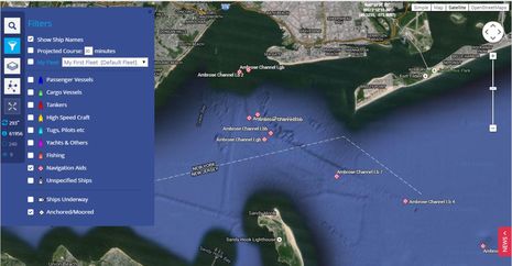 One way to spend a frigid night in Maine is learning about AIS AtoNs, an electronic augmentation to the aids to navigation we commonly think of as nav buoys, lighthouses, beacons, etc. The US Coast Guard recently began a year-long experiment with AIS AtoNs in New York Harbor, and sure enough, there they are on Marine Traffic. MT is an imperfect tool for understanding what AIS AtoNs look like on our boat displays, but if you set up the Filter as I have above — Show Ship Names on, all vessel types but Navigation Aids off — you can see that they are now set up around many major U.S. ports and that we’re behind much of the world. There are three major types of AIS AtoN, along with many nuances, and their capabilities seem impressive, though perhaps a little confusing or even scary for some mariners…
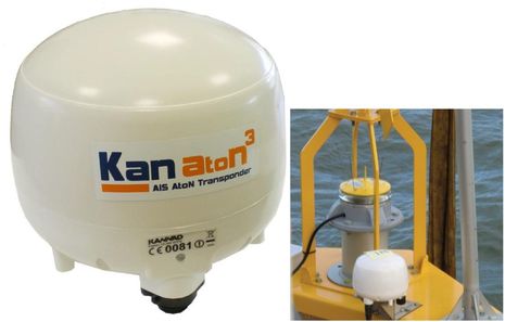 The most obvious variety is what’s called a “Real” AIS AtoN, like the McMurdo Kanaton above. What’s real is that the transceiver (or transmitter) is installed on a physical aid to navigation. The hardware is vaguely similar to an AIS transponder on a boat, though you’ll learn that there’s a lot more to it if you dig into this IALA Guideline PDF (credit to Jim Hebert’s good AIS AtoN research at Continuous Wave). For instance, there are three (sub) types of Real AIS AtoNs. And even the basic transmit-only type 1 can accept sensor input, and thus, report on the status of the nav aid’s light or RACON as well as weather information. The type 3 Kanaton above also has a receiver and can relay messages transmitted by a nearby AIS SART/MoB device or safety messages set up by an AIS base station ashore.
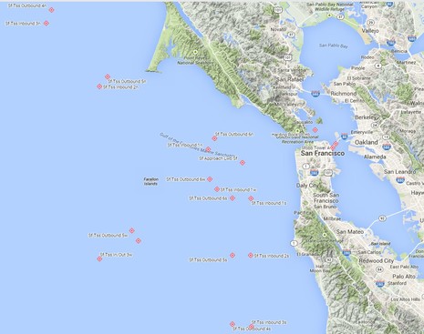 To my knowledge, though, the USCG is not experimenting with Real AIS AtoNs, and here’s where the confusion may begin. A transponder that is where it tells you it is makes more sense than the fact that all those AIS AtoNs seen on Marine Traffic around San Francisco are being broadcast from one or more shore towers. That’s possible because an AIS receiver cannot determine where transmissions come from; it only knows what it’s told (and hence there is an issue with AIS spoofing, though it’s largely overblown). To add to the confusion, there are two distinct types of non-Real eATONs, to use an acronym the USCG likes. A Synthetic AIS AtoN is electronically “located” at the same spot as a physical AtoN while a Virtual AIS AtoN only exists on AIS displays.
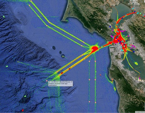 The general idea is that Synthetic AIS AtoNs can augment existing aids — like Real AIS AtoNs, but without the hardware hassle and expense — while Virtual AtoNs can go where physical ones don’t make sense or where one is needed quickly. So many of the Synthetics around San Francisco correspond to the actual buoys marking the Traffic Separation Scheme, as suggested above using Marine Traffic’s vessel “density” overlay (now available with the free subscription). {Correction 1/10: Actually many are Virtual AtoNs set right in the traffic lanes; see OpenCPN screen at end.} Recreational boaters with AIS displays might use the new aids to help them stay the heck out of the way.
 Meanwhile, Virtual AIS AtoNs are being used to mark the towers under the Bay Bridge, like the one that got in the way of the 900-foot M/V Cosco Busan one foggy morning in 2007. Virtual AtoNs can also be used to quickly mark, say, a vessel that sinks just below the surface in a channel or to permanently guard a dangerous ledge in a remote area (like this Vesper Marine install)…the uses seems almost infinite. And I think that both Synthetic and Virtual AIS AtoNs can be deployed almost anywhere along our coast, because they can be broadcast not just from the AIS base stations typically found near major ports, but also from the NAIS towers that are trying to monitor all AIS traffic off our coasts. (And, yes, it is valid to ask, “Why isn’t the public AIS portion of NAIS data available to the public?” in my opinion at least.)
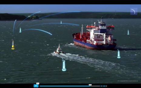 Incidentally, Real AIS AtoNs can create Virtual and Synthetic AtoNs, as explained in a neat YouTube video that goes with the Carbon model SRT builds for OEM distribution.
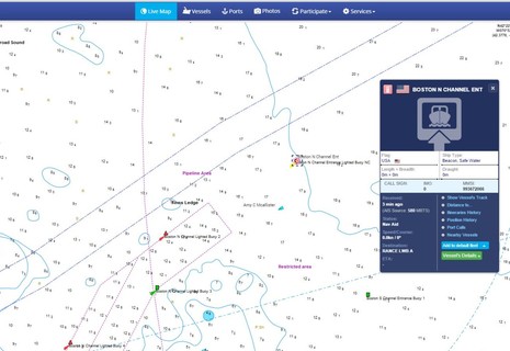
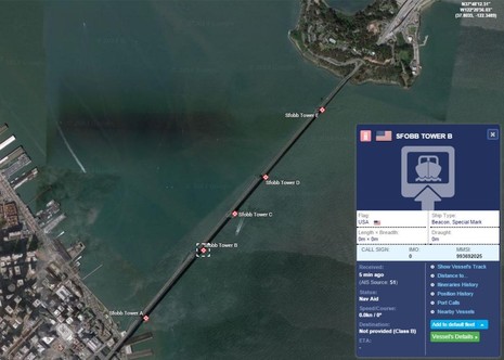
So how do AIS AtoNs display on a multifunction nav display or charting program? I really don’t know! I saw some on the SeaPilot app while visiting True Heading in Sweden but have not yet spotted one on any of Gizmo’s many AIS displays, probably — but not necessarily — because I haven’t been within range of one yet. The screenshot above was taken of Marine Traffic before I lost my Pro subscription with its choice of Navionics chart underlay (remember that you, too, can earn a Pro or Premium sub by maintaining a volunteer listening station, and there can’t be enough.) And while it’s nice that MT shows AIS AtoNs at all — some other Web AIS viewers don’t — the site does not display them correctly. While it is translating AIS Message 21 for AtoNs, some of the info is squeezed into a data box meant for vessels, and I think that some isn’t displayed at all. That’s why “RANCE LWB A” is not the Destination of “BOSTON N CHANNEL ENT” but rather the rest of its name!
![]()
Marine Traffic is also using the same icon for AIS AtoNs as it uses for moored vessels, and that’s not right, either. I found the graphic above in a USCG AIS ATON Special Notice PDF and you can see that while Real and Synthetic AIS AtoNs intend to look the same, Virtual AtoNs get different treatment. By the way, there’s a “CAPE CAN DGR A” AIS AtoN operating just north of Cape Canaveral, Florida, right now and wouldn’t it be great if an enterprising Panbo reader got screenshots of how it looks on their boat displays?
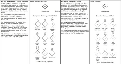 But note how the USCG graphic shows how an “Isolated Danger” AIS AtoN will potentially be portrayed. By the same token, the graphics above showing more types of AIS AtoN icons come from a draft of IEC 6288 Ed. 2. I also read somewhere that even ECDIS displays are not yet required to show standard AIS AtoN icons. All this makes me nervous about what the state of affairs is on recreational displays, but of course many of you out there can help.
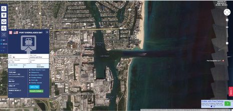
As noted at the beginning, Marine Traffic shows AIS AtoNs in many places along the U.S. coast and many, many more around Europe and Asia (though the ones I saw properly displayed on SeaPilot are oddly missing). Are they showing up on your displays? Do the icons look right? Are long nav aid names shown correctly? Are there data fields to indicate if an aids light or RACON is working correctly, or if it’s off station? Please tell us in the comments and if possible, please send screenshots (ben at panbo.com) for a followup entry. Bonus points for a screen showing AIS AtoN weather info, because that’s a subject of much more complexity that may also merit an eventual entry. Myself, I hope to “see” the AIS range marks and entrance bouy in Miami during the February show, but won’t really get going in Gizmo until April or May.
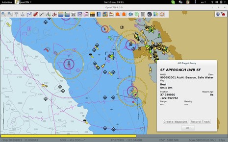
PS 1/10/15: This screenshot indicates that at least the charting program OpenCPN can display AIS AtoN message 21 pretty well, and also that I was confused in the text above. Most of the AIS AtoNs marking the San Francisco traffic lanes are Virtual, not Synthetic. More in comments below.


We just transited through Key West, fl. There are virtual beacons for the harbor approach that show up on the marine traffic site but I didn’t see them at all on my Garmin suite (6212 and 8212) as well as on Coastal Explorer.
Thanks, Shanti (Brian), though that’s not what I was hoping to hear! Is your AIS data getting to the target displays via NMEA 0183 or 2000? So far I have not been able to determine if AIS message 21 has been translated into a N2K data message (PGN), though I’ll be astounded if it hasn’t.
Incidentally, it looks like all the experimental AIS AtoNs that went live last month in Key West and along the west coast of FL are Synthetic: http://goo.gl/tRmV6t
Also, if you could see those Synthetic AIS AtoNs on your nav displays, do think they would be useful? Virtual danger AtoNs seem undeniably valuable but Synthetic/Real ones may take some getting used to, if we do get to see them on our nav screens at all!
Ben…
Virtual AtoNs show just fine on OpenCPN. I posted you a screenshot at http://postimg.org/image/hbiwz1z5r/
Yes, if I could see Synthetic AIS AtoN’s on my nav displays, and their positions were updated within weeks of aids being moved, that could be “useful”. Perhaps not valuable, but useful.
When aid’s go missing, I would upgrade from useful to valuable, especially if they appear on our chart plotters differently for synthetic (I know to look for them as I pass) vs. virtual.
I was just wondering, Who’s responsibility is it for processing the AIS AtoN’s,- the AIS receiver or is it a function of Coastal Explorer / Garmin to accept the AIS message 21? Do I need to wait for a software update from my Vesper AIS XB8000 or is the chartplotter and charting software holding up displaying the data?
I can see many situation where a virtual AIS AtoN would be very helpful.
Well done, Pavel, though your screen shows that many of the traffic scheme AtoNs off San Francisco are Virtual, not Synthetic as I thought.
I can’t find a detail list of the SF AIS AtoNs but it looks like you’re making the correct data translations. And when I look at the density map more carefully and think about the use, it makes sense to put Virtual AtoNs right in the fairway where ships can navigate right over them without hitting anything.
You do seem to be using IEC edition 1 Virtual icons instead of the dashed line version in ed 2 and also wouldn’t it be more correct in your Target Query to interpret the Flag as “Real or Synthetic” instead of just “Real”?
Also, may we presume that you are using NMEA 0183 AIS data? Have you tried the NMEA 2000 version?
At any rate, I’m going to add your screen as a PS. Thanks!
Good news about NMEA 2000 support for AtoN message 21 from Jeff Robbins of Vesper Marine (slightly edited):
“Yeah it’s there… PGN 129041 is AIS Aids to Navigation Report. Our transponders produce it. I think NMEA added it in V2,00 (Jan 2013).
Virtual vs. Synthetic shouldn’t matter for the display since they both use message 21 and it’s just a flag bit and some minor differences in the interpretation. All our WatchMate displays and transponders since the very first one have displayed AIS AtoN’s and they support real, synthetic and virtual.
As you know, we have lots of customers using virtual AtoN’s via our Virtual AIS Beacon and they report that about 70-80% of ships have visibility on their ECDIS or other displays.”
So, Richard, the Vesper XB8000 on your boat and mine can output AIS AtoN PGNs. If they don’t show on our displays that will be because the manufacturer is not yet supporting the PGN. Both parties have to play.
Ben and Jeff,
Thanks for that info on the XB8000. It’s too cold here for me to check on the boat. I did send an email to Coastal Explorer and received an immediate reply regarding their AIS AtoN Message 21 capability and yes, they also have had the capability for some time.
Coastal Explorer support told me this must be turned on to enable. Go to, “Main Menu > Options > AIS > Show Aids to Navigation” and you should see the AIS AtoN targets on the Coastal Explorer chart.
We just sailed back to Palm Beach (from Canada) and were surprised to find one AToN at the first starboard buoy of a number of inlets.
Our B&G Zeus and Zeus Touch displays showed a rhombus with a cross inside for each.
I do not think those were in place when we left in May.
I would speculate the atoNs were physical because the AIS locations matched so perfectly the radar returns. But have no insight. The AtoNs displayed only MMSI, lat/Lon, and a cryptic vessel name, if I recall correctly, of the type LWRTENT or so (lake worth entrance????)
I was disappointed the AtoNs were on the first starboard buoy for each channel and not on the sea buoy, because as we sailed from Georgia we hugged the coast but outside each inlet’s sea buoy
Synthetic or virtual atoNs are scary. If a buoy becomes unmoored and 10 years from now one is on “smart” autopilot following atoNs, one will be likely to hit the physical unmoored/moved buoy and sink.
Thanks Xavi!
I agree with your preference for marking sea buoys, but that’s usually where they start. In fact, I can see the AIS AtoN named “LW INLET LB LW” off Lake Worth on Marine Traffic and am confident that it’s a Synthetic AtoN corresponding to the sea buoy “Lake Worth Lighted Buoy LW.”
I also found the elusive list of East Florida AIS AtoNs buried in the 1-15 LNM:
http://www.navcen.uscg.gov/?pageName=lnmDistrict®ion=7
But I don’t understand “Synthetic or virtual atoNs are scary.” Both types are just data broadcast from a tower on shore; they can’t move on their own. One of the benefits of a Synthetic AtoN is that it stays on location even if the physical buoy it corresponds to sinks or drifts away. Even a Real AIS AtoN is designed to know when the buoy it’s on goes off station and broadcast that fact, though of course the AIS display software has to know how to make users aware of that.
What seems to scare some people about AIS AtoNs is the notion that Virtual ones will eventually replace existing physical aids. The USCG is certainly not doing that now, but obviously it might make sense eventually.
They show up with proper icons and data on my TZT using either the FA150 or the Link8 as the receiver
USCG Puget Sound AtoN presentation: http://goo.gl/oz3QZg
I was off Cape Canaveral 2 weeks ago, but didn’t know about the ATON there. Too bad. Would have been interesting to see how it displayed. We did see two large cruise ships leaving Port Canaveral, though, and AIS was very useful in understanding what they were and where they were going.
I think the Vitual ATONs would be useful for inlets where the channel shifts frequently, so that the CG doesn’t have to move the markers. However, if they get used to this, the CG could quickly decide that a lot of other markers should become virtual, as well. Not necessarily a good move – some of us like to see the physical marker (especially if it is a fixed marker).
Another benefit for the CG from virtual markers is that it would force more boats to use AIS, which makes their task of tracking boats easier. Of course, boats that don’t want to be seen will turn off their AIS transmissions, though.
Ben…
The screenshot shows what comes in the NMEA0183 stream from SF bay area available online.
OpenCPN shows pure virtual AtonS as virtual, the properties window I had open is just by accident showing an AtoN siting on a real buoy.
I have put the upgrade of the symbols to v2 on my list, now that we know how they look 🙂
Thanks, Howard! Can I presume that your TZT is getting AIS data from the FA150 via NMEA 0183 or Ethernet and from the Lowrance Link-8 VHF via NMEA 2000?
Also, in the TZT settings menu you can enable screenshots as a two-finger tap gesture 😉
The Feb. 2014 USCG presentation you linked to doesn’t have much text but I noticed that two “eNav Challenge” listed is:
• Electronic ATON (e-ATON) Symbology – International Agreement Pending (expected CY 14)
(Which seems to confirm my sense that AIS AtoN icons and data display is pretty new and may not have made many of our displays yet.)
• Expanding AIS to all US Waters – Currently in Routing
(Which I think references a major expansion of AIS mandates on U.S. commercial vessels that may finally be ‘routing’ its way out of the federal bureaucracy 😉
Thanks, Pavel. The point I was trying to make is that the Harding Rock AIS AtoN is Synthetic not Real, I’m pretty sure. But I have to admit that the Message 21 listing ( http://goo.gl/g2oGhP ) is confused on this subject, describing the Virtual AtoN flag bit as either:
0 = default = real AtoN at indicated position
or
1 = virtual AtoN, does not physically exist.
This definition makes it impossible to flag a Synthetic AtoN. However, the IEC symbology recommendations seen above clearly show that Real and Synthetic AIS AtoNs are meant to be treated the same.
So shouldn’t the “0” flag be interpreted as “Real or Synthetic”? OpenCPN could be in the vanguard 😉
The FA-150 is connect through a Furuno NMEA0183 to NMEA 2000 IF2K converter, and the Lowrance is on the N2K as well. I have turned off the AIS output.
Screenshots, hopefully this afternoon, if I can receive the ATON from Lake Washington.
Cool. Pavel tipped me to the HD-SF AIS feed now hosted by the fabulous SF Exploritorium: http://hd-sf.com/
It works as a data port in Coastal Explorer like it does in OpenCPN and I’m watching ships, tugs and pilot boats working around the San Francisco TSS right now.
As Richard learned, CE shows AIS AtoNs if you turn them on. The icons for Virtuals don’t seem to IEC code yet, but Rosepoint did a semi-clever thing with the Virtual flag. It’s expressed as either Yes or No, so a Real or Synthetic is not really identified but also not misidentified 😉
Thanks Ben, very interesting post. Last week the grounding of the Hoegh Osaka in the Southampton waterway in the UK showed some of the benefits of Virtual AtoN. In this case, the “wreck” was quickly marked by virtual AtoN transmitted from a nearby “physical” AIS AtoN mounted on Calshot Tower. The configuration was carried out remotely. See:
http://www.srt-marinesystems.com/case-study/virtual-aton/
A great use, when the virtual system is more “mainstream” will be fields of lobster/crab traps, especially when they are near the entrance to harbors! They are actually dangerous, but it is legal to drop them all over the front of a breakwater here in California. It would be great if a target was showing on the MFD.
As to the concern of AIS on a real object and what if the object is loose, you have the problem in the dark regardless. Radar? FLIR? Eyes?
AIS is just more information that you can use, or not use.
Anchoring in a popular anchorage is always a worry, especially with boats coming in late that are not aware of where all the anchors are. Putting a buoy on the anchor has issues that have been discussed endlessly on various fora.
I wonder, therefore, if one day the technology and rules will develop so that the class B AIS of the future may allow us to identify a virtual AtoN for our anchor drop point so that other AIS equipped vessels coming in to the anchorage can see where it is?
Just day dreaming.
International Standard IEC 62288 Edition 2, Maritime navigation and radiocommunication equipment and systems – Presentation of navigation-related information on shipborne navigational displays – General requirements, methods of testing and required test results, published July 2014, specifies requirements for the presentation of navigation-related information on shipborne navigational displays in support of IMO requirements.
It is here that AtoN symbols, both physical and virtual, and specified. Any ECDIS or radar that is IEC 62288 Ed2-compliant and connected to an AIS should display these symbols.
You can view the virtual AtoN symbologogy requirements from a screenshot extract of the standard here: http://postimg.org/image/vdso51l1r/. The standard is otherwise copyrighted and available for purchase from either the IEC or ANSI website.
By the way, IEC 62288 Ed2 contains requirements for display of a plethora of other AIS symbol, including ships in different maneuvering situations, SARTs, AIS on aircraft, and several application specific messages (eg maritime safety information, meteorological information, tidal and water level) as well.
IMHO, one of the most valuable things about the new AIS AtoN technologies — especially the virtual AtoNs — is that countries without sufficient financial resources to place and main physical AtoNs can almost certainly find ways to use single (somewhat tall) towers to create virtual AtoNs for dozens, possibly hundreds, of otherwise non-existent, but definitely needed, markers. The Bahamas come to mind as an ideal place to start 🙂
Thanks, Joe, and good to see that the finished AIS AtoNs are the same as the draft version I published above. I realize that the material is copyrighted but I believed that my use of less than one page out of 120 meets the fair use doctrine. And I wouldn’t have found it at all except that the USCG published some excerpts (with typos I fear) and the IHO made the whole IEC 6228 Ed 2 draft doc Google searchable:
http://iho.int/mtg_docs/com_wg/CSPCWG/CSPCWG9/CSPCWG9-INF1_Draft_IEC_62288_Ed2.pdf
Note that I entirely endorse the IEC’s right amd need to charge for publications, but hopefully no sane manufacturer would use the draft version to create products.
Excellent point, SheltieJim. I’ve been travelling all day — to a boat in North Carolina almost as cold as Maine! — but before I left I had the opportunity to see the San Francisco AIS AtoNs overlaid on the latest raster charts, and it’s a beautiful integration. I’m also obsessed with the saga of the auto carrier Hoegh Osaka that Mark mentioned above and I hope to wrap that all into a followup entry tomorrow.
This probably explains why Shanti couldn’t see the AIS AtoNs around Key West. Garmin reports that “According to the engineers, that PGN {129041, corresponding to AIS AtoN message 21} isn’t currently supported by the AIS 600 and also isn’t supported by the MFD’s chartplotters.”
I suggested that PGN 129041 support go to the top of the to-do list and have some confidence that it will be fixed soon as Garmin is particularly responsive to safety issues.
Scary? Hmm, don’t get it.
If anything is a little scary (just a little) is an amateur boater getting the misconception the virtual AIS information is exactly correct, based on past experiences with a set of channel marks, not appreciating that atmospheric conditions on the boats GPS receiver can have the effect later that night making the “real” position of the boat on the MFD and the “virtual” position of the mark (not subject to atmospheric conditions or current in the channel) appear a boat width apart, when actually it is in the path of the boat.
Would that be AIS assisted collision, GPS assisted collision, both or neither? 🙂
Hi Ben,
FYI and your readers our Boat Beacon iPhone and Android app and our free Boat Watch apps both show AtoN’s, marking them with the correct buoy or marker they are describing and also lists in the details view whether they are virtual or not and if they are “on station” – e.g. haven’t drifted.
There is a screen shot here showing lots of AtoNs of various types on the approach to New York
http://boatbeaconapp.com/atons/IMG_3687.PNG
and here is the description
http://boatbeaconapp.com/atons/IMG_3688.PNG
http://boatbeaconapp.com
The USCG recently began transmitting signals for AIS AtoN targets in my area, the Detroit River, Lake St. Clair, St. Clair River, and Lake Huron. I have received some AIS AtoN Synthetic targets and show how they are displayed on a first-generation Lowrance HDS-8 chart plotter at
http://continuouswave.com/forum/viewtopic.php?f=9&t=229
I was surprised the first-generation HDS-8 was able to show these targets. Its firmware was last updated almost four years ago (February 2012). It was nice to discover that Lowrance/Navico were ahead of the game and their older product could show AIS AtoN targets.
I have just installed a Raymarine C125 MFD and an Actisense NGW-1-ISO-AIS to partner with my existing Vesper Watchmate 850. While the vesper and PC using opencpn directly connected to it correctly display AIS ATONs, the Raymarine display via the actisense gateway shows only vessels. All are on latest release software/firmware. Does anyone have any idea what’s going on with that? Conflicting implementation of standards? Lack of implementation of standards? A well hidden software switch I am yet to discover? Any and all help and suggestions welcome!
Thanks all
Actisense tech support replied, and they tell me that:
“AIS AtoN (NMEA 2000 PGN 129041) is not currently supported by the NGW-1. We are planning to add this conversion to the next release of NGW-1 firmware. Unfortunately I cannot say when this new firmware is expected to be available.”
Which I find a disappointing. It seems unless you install a native NMEA 2000 AIS unit, you are out of luck for now. I do enjoy the Vesper style warnings and low power setup so I want to stay with that unit, I wish actisense would keep up with the standards and real world capability of AIS. To get chart overlay of AIS ATONs I have connected the Vesper unit directly to a PC via USB, leaving the Raymarine MFD out of the equation for now.
Garmin MFDs and AIS units still do not support N2K PGN 129041.
Is this supported by Garmin and others?
Is there an inexpensive way for a sailboat race commitee to broadcast these?
AtoNs would be great for sailboat racing, rather than each boat pinging the end of the start lines.
Race Committee:
– From a smartphone, allow user to ping marks and the flagstaff on the committee boat. Auto adjust the reported location of the flag as the boat changes position, swings on the hook.
– Show the race committee the information they need to post at race start, e.g. mark at 120 degrees, 1.1 miles
– Broadcast to racers information such as a change to the Sailing Instructions, race abandonment, the intentions of the race committee in respect to next race, weather, etc.
Race Competitors
– Receive the precise location of the race committee boat and marks, rather than pinging them manually.
– An additional method to confirm instructions offered by the race committee
Dan, this entry is five years old. It did take Garmin a long time to add MFD support for AIS AtoN information coming in over NMEA 2000, but I think that most every AIS display does now.
As for temporary Synthetic AIS AtoN over sailboat racing marks, I don’t think so. They are regulated by regional authorities and while I believe that the USCG AIS division is quite open to new ideas, I doubt that conventional racing would be deemed an approved use, and ground stations normally used are not trivial
However, I have seen Vesper AIS AtoN tech used to mark the spectator boundary at a really big race in a very congested harbor:
https://panbo.com/geeks-win-americas-cup-34-larry-e-oracle-team-usa-also/
Great Link thank you Ben!