
Garmin visit #2, GPSMap 78
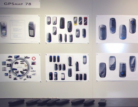
Today Garmin introduced the GPSMap 78 series, an apparently major refresh of the 76 series long popular with boaters. While I only got to fiddle with a pre-production unit for a moment, I did learn a lot about the industrial design process behind it. The ID department in Olathe — aka “The Skunk Works” or “Area 51” — has a tool collection that would make all sorts of craftsmen and artists drool, but I’ll save that story for another day. What’s particularly notable about the exhibit shown above and below is how many design iterations were created and modeled for the 78, and how detailed they were…
And there was lots more to the process than shown here. The design software, for instance, could calculate whether the various shapes would float, but the design team also inserted appropriate weights into models and dunked them. (Incidentally, I lost track of how many different rapid prototyping systems the ID dept. has at its disposal, each apparently better suited for particular steps of the design process.) Garmin is justifiably proud of the ID facility and the talents in it, but made a special point about how it fits into the company’s emphasis on vertical integration. Many manufacturing companies contract industrial design out to specialists, but it’s hard to imagine how that could be as collaborative and as efficient as what goes on in Olathe. The evolution illustrated on this wall happened with regular input from the hardware and software engineers involved with the 78, as well as the marketing and sales teams. There are also processes in place, formal and informal, to encourage cross pollination amongst Garmin’s several product groups, and to collect input from users via various channels, but those too are stories for another day.
 So how did the GPSMap 78s turn out? Well, they won’t actually pass through that giant warehouse and out to stores and reviewers for a few weeks, but I did notice some interesting specs and features. Like 1.7 GB of internal memory and a micro SD card slot, which might be especially useful with the relatively new BirdsEye Satellite Imagery service and/or the custom map feature. These handhelds can be used with BaseCamp topo software, but they’ll also play nicely with the somewhat similar HomePort planning software, reviewed here recently, which is important, I think, because creating routes on a small display is hard no matter how fast it is. I look forward to trying a 78, or least reading what a good review site like GPSTrackLog has to say about it. I already think it looks good, perhaps even more so now that I’ve seen how much care went into that look.


This looks like an ideal form factor for an Android based device that would allow us to use the new boating applications that are coming out for smartphones which are terribly underpowered for continuous display usage and are not water proof.
Applications for managing checklists, inventory, POI information, etc.
This form factor allows for much larger batteries (than a smart phone), dedicated buttons for specialized GPS functions, waterproof, etc. With all of this I can imagine the following:
– A version where the screen is a touch screen, but the dedicated buttons stay.
– Android based operating system, in which you can switch between GPS function and Android applications that are purchased.
– Whenever you push any of the dedicated GPS buttons, whatever Android application is running is pushed to background and instantly replaced by the Garmin application.
– The Android applications have access do the GPS data, e.g. you can have your own anchor watch application rather than use the existing, etc.
– No 3G needed, but include wi-fi capability not just to get google android applications downloaded, but as well be able to download new version of garmins GPSMAP, topography updates, Active Captain POI (does AC mobile work without 3G signal?), etc.
What did I miss?
and no new GPSMAP 68 ? I’m sure you have wide photos of these panels 😉
I wish they would spend as much effort on making units marine useful (averaging speed and course over user defined period for example) as they do on making them look slick. My Oregon 400c lacks a number of basic features like this that my much older Garmin units sported.
Dan. No 3G what planet are u on. It’s high time that any device that’s proports to be comma orientatwwd should have 3g out of the box. I currently am writing this on my boat with a 3g iPhone.
We surely don’t need to buy monthly 3G data plans for our GPS’s? This product isn’t likely to find it’s way off the boat, too much $ to buy a data plan for everything. Besides, as long as it has wifi it can be tethered to a device with 3G, which one day soon may include iPhones.
I agree, Dan, smart phones will become portable hot spots for multiple devices. But I don’t agree that the 78 will stay on the boat all the time. They’re optimized for marine, but support all sorts of mapping:
http://garmin.blogs.com/my_weblog/2010/04/new-marine-handhelds-hit-the-scene-.html
While visiting Garmin, I also got my hands briefly on a new Nuvi 3700, which is startlingly light and sexy. Pretty good video on its design process here:
http://garmin.blogs.com/my_weblog/2010/04/new-n%C3%BCvi-3700-series-redefines-look-and-feel-of-personal-navigation-.html