
Garmin Panoptix All-Seeing Sonar, GPSmap 7×16, and BlueChart Mobile 2.0
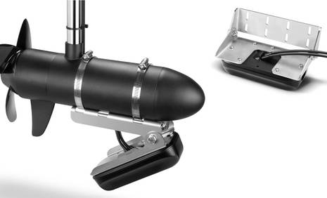
The Garmin Panoptix “All-Seeing” sonar announced this morning sounds fascinating, but be aware that it’s meant for smaller boat fishing, at least at first. The $1,500 rectangular “multi-beam transducer that utilizes a phased-array scanning sonar technology” will come in two styles, with the tilted Panoptix Forward model oriented vertically on a trolling motor or transom mount and the Down Transducer with its horizontal orientation only available for transom installs. Neither one looks easy to transform into a thru-hull fitting but judging from the screenshots a lot of bigger boat owners will be hoping that’s possible…
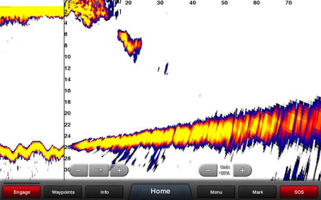
This is the PS31 Panoptix Forward Transducer purportedly imaging 80 feet of slightly upsloping bottom and also a diver about 20 feet ahead of the transducer in what Garmin calls LiveVü mode. It looks similar to Simrad ForwardScan but is covering a wider wedge of bottom and water column and is said to be so fast that you can watch your lure being reeled in (which is what’s happening in the first GIF animation on Garmin’s dedicated Panoptix page).
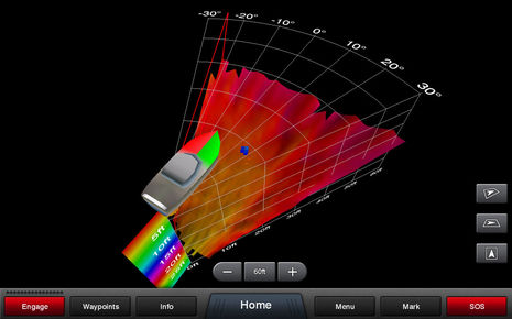
But, whoa, I’ve only seen what Garmin calls RealVü 3D mode on much more expensive sonars like the EchoPilot 3D FLS. This is no doubt a slower mode but the user can control the speed for desired level of detail. Note how this particular RealVü viewing angle shows the 60 degree coverage of the Panoptix Forward Transducer and also how it can paint bottom and fish (or diver?) detail not just forward but from side-to-side within the phased-array beam.
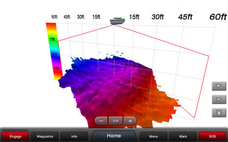
It’s no surprise then that the PS30 Panoptix Down Transducer can create a rectangular RealVü below the boat. It can also assemble these into long swaths called RealVü 3D Historical or do LiveVü Down imaging that supposedly let’s you pinpoint fish and/or bait. And get this: both Panoptix Forward and Down are said to work fine when a boat is stationary and both contain AHRS sensors to compensate for boat motion underway or at rest.
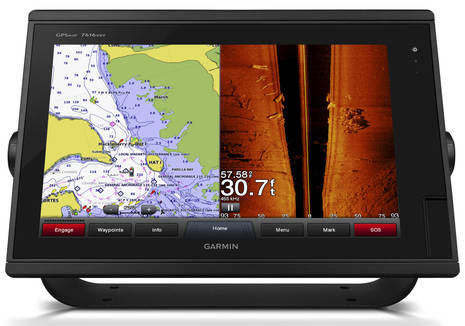
The Panoptix transducers are “expected to be available in the spring of 2015” and will work with a variety of current Garmin MFDs, including the GPSMap 7×00 series that was announced at Lauderdale and is slated to ship very soon. The series already looks to me like a nice ‘value’ version of the 8000 Glass Helm displays and now it will be available in a 16-inch version. In fact, the GPSmap 7616xsv version will retail at $6,000 with built-in processing for not only Panoptix but CHIRP DownVü and SideVü plus dual-channel 1kW CHIRP sonar…quite like the Simrad NSS16 that looked so good in my glass bridge price comparison. Hello!
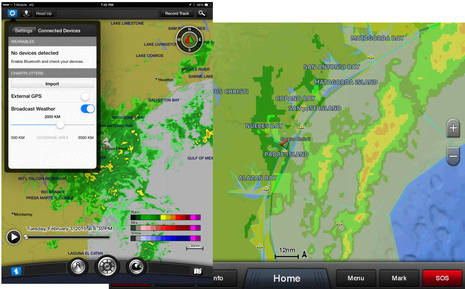
Finally, the already able planning app BlueChart Mobile will greatly expand its weather resources when version 2.0 comes out this summer. Included will be “weather observations and buoy reports, marine zone forecasts (US/Canada/Europe), land zone forecasts (US/Canada), surface wind forecast grids, sea surface temperatures, surface pressure forecast and and sea state forecast, plus in-app purchase purchase options for radar and infrared cloud imagery, lighting, and StormWatch watches.” And here’s the kicker: with BCM 2.0 owners of Garmin WiFi-enabled MFDs will not only be able to pass routes easily but the updated weather data will stream to the bright readable MFD screen as long as the BCM iPad is online (which is most of the time on Gizmo thanks to my cell boosting system).
Well, actually the real kicker for me is that I’ll be on the water with Garmin Panoptix this afternoon in Miami (and that’s only one of four demo rides today ;-). I’ll report back when possible but don’t hestitate to post questions I might ask now.
PS 2/20: The Panoptix demonstration in Miami was quite impressive. I think the technology truly is a significant new kind of sonar, even though we’ve already seen so many great developements in recreational sonar during the last few years.
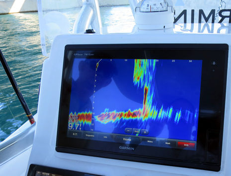
The demo boat was a small center console with the Panoptix Forward Transducer mounted on a trolling motor at the bow, and it didn’t take long to see what a slick rig this could be for lake and coastal fishing. The screen is showing how the concrete bridge abutment steps back, a detail I’d never seen in several side and down imaging demos under the same bridge. Moreover, the image remained the same even when we stopped dead and I missed photographing the fish we saw first lurking in that step back and then meandering towards us. We also tracked lures and saw that Panoptix even has an echo trails option (like radars) that can mark lure and fish movements. The echo trails also showed the heave motion happening on a small boat full of people in a busy waterway, but heave is the only vector not corrected by the transducer’s built-in motion sensor; roll and pitch didn’t distort the imaging at all.
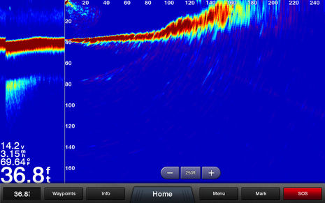
Panoptix RealVü 3D mode was also working well — and can be split screen with LiveVü — but it clearly takes some getting used to and probably some familiarity with its many controls to make the most of. Of course I was really interested in how Panoptix Forward might serve as a grounding avoidance forward looking sonar (FLS) and when we were headed back toward the bridge I forced the range way out. We actually started targeting the shallower water and bridge abutments at nearly the 240 foot screen max seen below and if we’d been able to separately reduce the depth range the strength and certainty of this difficult sonar targeting would compare even more favorably to the Simrad ForwardScan I already find useful. But let’s be clear, Panoptix is not available as a thru hull transducer and is not yet FLS as we commonly perceive FLS. But, man, does it have potential!


And I just heard this morning that Raymarine is introducing “new CP570 Professional CHIRP sonar, CP470 CHIRP sonar and CP370 digital sonar” while FLIR has new “M400 stabilized multi-sensor” and “handheld Ocean Scout” thermal cameras… many of which I may get to see in action today. Yeehaa!
Any chance of BlueChart Mobile for Android? Been waiting on this a long time.
Hi Ben,
I am a dedicated fan of your blog.
I am living in Tokyo JAPAN.
Garmin GPS Fishfinder/sounder is not so popular in Japan comparing to US since a local agent has not promoted them. So I have been reading your blog to get the latest news in US.
This new sonar is fascinating. I wish I could have one on my boat.
Would you ask Gamin if they will sell it in Japan?
Thanks.
Hi Ben
re: BCM.
Latest version’s waypoint and route creation has improved. I particularly found “snap to waypoint” useful when creating a route from existing waypoints.
That said, there are still a few issues I’d like Garmin to address in BCM 2.0. Maybe you could bring this up @ MIBS?
1. Foremost. Provide the ability to import/export all the waypoint/route data in a standard format usable on non Garmin products. I believe that means GPX and I think that also means email. This issue is a showstopper for me.
2. Zooming in and out to force display of navaids continues to be a pain.
3. Provide an easy way to create a waypoint from a highlighted navaid, using the navaid’s coordinates.
4. Provide a way to easily adjust/correct waypoint position.
5. Provide a way to examine route leg distance and bearing BOTH in the forward AND reverse direction.
6. Offer a sail/power operating mode choice. As a sailor, I just don’t care about any of the fuel consumption information. Its clutter for me.
Garmin has all this feedback now for over a year.
Thanks
Hi Ryota,
In the upcoming 2015 Japan Boat Show (Yokohama) from March-5th, Garmin will exhibit Panoptix during the show. Please come take a look and ask any question you have.
We look forward to your visit.
YC
Hi YC,
Thank you for the info.
Looking at the Japan Boat Show 2015 web site, I can not find the name of GARMIN. What booth do you present the equipments there?
Please advise.
Best
Ryota
I just added some Panoptix demo images and commentary. It’s pretty amazing.
I also appreciated a demo of the weather improvements and streaming coming to BlueChart Mobile 2.0. You can even mind some weather elements on the iPad screen while choosing other ones on the MFD.
I’ve got GPS 800/1000 SideVu/DownVu and I love it and I hope they come up fit up to it as it would be great
Just wondering, how deep does the Panoptix work? I normally fish in 25-65 feet of water. Is it useless at these depths?
Hi Ben
I am a small boat operator and looking to upgrade my electronics. Garmins’ website shows backward compatibility of their Panoptix ducers with their echoMAP 70dv (discontinued) but not with the newer version echoMAP 73dv. What happened to the 70dv? Were their problems with the touchscreen? The real world price on the touchscreen 70dv has been all over the place and now the price is increasing rapidly and the unit is hard to find! Your blog is great for an old dog wading into the new world of gizmos.
??Why not combine Panoptix with the Interphase technology..ie use their through hull transducers .. use some of their software… Clearly there must have been a reason to purchase Interphase’s technology…
The Garmin Blue Chart Mobile 2.0 update is out and looking good (so far, haven’t tried the weather to MFD streaming yet):
https://itunes.apple.com/us/app/garmin-bluechart-mobile/id523635526?mt=8
Anyone want to assist/invest in a similar design we’re working on? For GROUND seeking of gold, copper, lead, water etc.? Also if aimed at buildings, produces same type of 3D visible results???
Contact [email protected]
Subject line: Detector
Great, yet still primitive. Finally, 1975 Technology coming in use, for the general PUBLIC to use.
Hi Ben,
What are your thoughts on Panoptix using the thru hull transducer in 100′-500′ of water for BBFT. I cant seem to get a refence from anyone in the north of Boston market so Im reach out.
Any help would be appreciated.
Thanks
Jim
Sorry, Jim, but I have no idea what BBFT is. However, I suspect that the depths involved are a bit much for the current Panoptix generation. Then again a reliable source told me about an amazing scene with the thru-hull version and some very good free diving spear fishermen. Apparently he was marking large fish as deep as 100 feet and then watching them get hunted and brought back to the boat on the screen. This video suggests the possibilities but I believe there is more stunning evidence some where:
https://youtu.be/vjS4r7SRPgk