
Garmin N2K AIS, & the 5.3 unfix
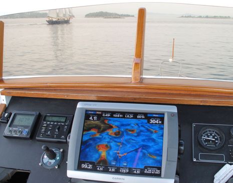
This was nice. It was Friday late morning — after the fog burned off but before the torrential rains arrived (summer of ’09 is making history!) — and we were idling along in company with the school schooner Tabor Boy. All of which was being colorfully portrayed on the Garmin 5212’s Mariner 3D screen; zoom in and you’ll see the Tabor Boy’s Class A AIS signal represented as a 3D icon with heading and track lines. You’ll also see Gizmo’s own Class B AIS represented as an unnamed dangerous target directly under our own boat icon, a little glitch we’ve already discussed…
Actually, I didn’t find that glitch very troublesome. I got a dangerous target alarm when I first turned on the Garmin, but thereafter it was just a ‘dangerous’ shadow. Besides, neither of the other plotters also connected to the Simrad AI50 via NMEA 2000 were getting any AIS, the Raymarine C140W because that software revision hasn’t happened yet, and the Simrad NX45 because it’s not really an N2K machine, just connected via an AT10 type translator.
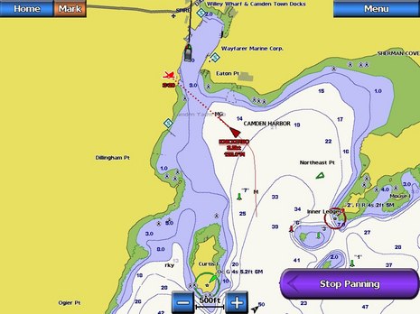
I’m also really liking what Garmin has done with AIS in version 5. The 3D icons in the 3D screen modes (there are several now, which is another interesting story) are fun, I think, but I’m also glad to see a more serious, even IMO-like, approach when in 2D charting. Check the screen below. The little green triangle over by the Northeast Pt is the Tabor Boy again, only now she’s in ‘sleep’ or ‘deactivate’ mode. There could be a lot of those little triangles on the screen without cluttering it. But I could also click on it (or pick it off a list that’s just two taps down from Menu) to see all pertinent info and then activate it if desired. Or if, like the mighty yacht Knickerbocker, she broke the CPA parameters I’ve set up, she’d activate automatically, getting a larger icon, track, heading line, and also that slightly goofy CPA icon. All good, I think, but there is a problem with this screen shot.
Note that my own Class B shadow target (seen as an MMSI because the Garmin hasn’t yet learned the new N2K code for Class B static data) is no longer there. I updated to 5.3 software just before taking these, and my first thought was “boy, they fixed that fast; wonder how they did that without me having to enter my MMSI #, like on the HDS?” But, alas, that’s not quite the case. Checking the AI50 screen I realized that there were two or three other AIS targets that the Garmin was not seeing. I do believe the 5.3 is not seeing N2K Class B targets at all. But I’m also hopeful that this is just a brief interlude en route to a complete solution. And that I’ll see Raymarine’s N2K AIS implementation soon, too. Right guys??


Do you ever get the feeling that this is getting very complex, expectations of incredibly crisp data, error free presentation and all susceptible to a crash like windows?
I can’t fix my computer and I can’t fix marine electronics. I feel I am at the mercy of this stuff, the engineers and the mfgs.
Actually, I think marine electronics are way more reliable than they used to be. These MFD glitches regarding AIS Class B over NMEA 2000 are pretty understandable. Class B wasn’t even legal here a year ago, and the NMEA didn’t get around to finishing the Class B part of N2K until recently. So it’s hard to fault Garmin, Raymarine, etc. for not being caught up yet. Bear in mind, too, that I could have full AIS on all three of those plotters if I used the NMEA 0183 ports (but I’m ornery).
Ben,
Don’t get me wrong. I love the gadgets and I think they produce incredible data. I remember the days of Loran A (not C) and “satnav” so in a few short decades we seen enormous progress.
I can’t afford to keep up frankly and worry that NMEA 0183 networks will not be supported soon and then I will be forced to do a major and very expensive upgrade to N2K when my gear starts dying.
Can we expect gear to run both 183 & n2k in the foreseeable future…my life time of a few short decades…. YIKES (look how much things changed in the last 2 decades!)
I sell all forms of marine electronics on a daily basis and from my observations the number of boaters who do not know what AIS and NMEA 2000 actualy are still greatly outnumber the number that do. That being the case I think it is pretty impressive how fast the improvments have been coming as of late.
Ben I haven’t updated to 5.3 yet, however my Garmin plotters consist of a 4212 and 3205 at the helm and a 4210 in a comm. center in my Salon. When I ran 5.2 it updated everything it recognized in the network. I am still running the Navico AIS-300 still on my N2K backbone. For testing purposes I usually leave it in the receive only mode so I don’t get the alarm. Both 4200 series plotters get the data, I get both class A & B. The 3205 does not recieve any AIS targets (it is on the Garmin network). I never thought it would because the NAVICO is on the N2K network and the 3205 is not. However the ships name doesn’t come up on class B targets but the heading and speed do. I can tell the difference by the length of the message when I hit the menu key, then other vessels then AIS targets (I think thats the order). I will write back tomorrow night when my wife and I get back on the boat if what I just wrote is wrong. Now what I am not sure is if the targets are being sent to both plotters thru the Garmin network or the N2K network. It is very interesting to see numerous targets and almost every weekend I am seeing more and more class B targets. When I installed this unit I rarely ever saw class B targets now when the band is open (almost every night) I am seeing more and more class B targets. That is if my assumption that the static data is much smaller on the AIS review tab and those targets show no ships name. I know this will be eventually worked out. I am not sure I will load version 5.3 if it eliminates class B targets?
Regards Bill Lentz
1993 40 Mainship Sedan Bridge
Little Egg Harbor, N.J.
This is an interesting debate and maybe moving slightly off target so I apologize in advance. But, the idea of these impressive electronic navigation aids are getting so real that I am affraid people are using them as their sole means of navigation. I am aware of the product disclaimers and common sense that accompanies (or should in the case of common sense) the use of these modern gadgets but still there seems to be a huge emphasis by users and race by manufactures to recreate on a screen what is happening outside of your window.
I heard a story about an impressive boat that hit a rock in a remote cruising ground. The owner (an experienced skipper) admits that the electronic chart does not replace paper charts and other navigation means but insists that the chart should have had the rock displayed. He’s got a point but there is nothing such as a perfect vector chart as there will always be somewhere on this planet that has an error or ommission when talking charts.
My personal feeling is that the on screen experience is becoming to realistic and much in the same way that we have a generation of kids playing video games and do not experience the great out doors, we’ll soon have a generation of boat owners who are too busy staring into their 21″ HD screen to know what it’s like to experience true boating. I’m not saying leave technology where it is but maybe less emphasis on it would encourage us to have a pleasant boating experience and enjoy the day for what it is.
PS! I’ve been in the marine electronics for 20 years and I have seen more and more people have their entire day and / or boating experience being ruined as they have spent the entire time trying to fix, connect, configure or understand a product that they really do not need.
I’ll happily play devil’s advocate, John!
For one thing, paper charts aren’t perfect either. And the widely used ChartKits can be particularly dicey because they often reduce the original scales. I was really struck recently off Stonington, Maine, when the rasters on my iPhone were way more legible than the ChartKit for the same complex area. The Garmin, Navionics, and C-Map charts also presented the data better (on fairly big plotters).
And while I’ve seen plenty of skippers dangerously lost in their electronics, I sure saw the same phenomenon back in the days of pencils and parallel rules. Navigation is about vigilance and knowing how to use the tools at hand without getting distracted. Today we have the best tools ever, and they’re getting better still, but many of us haven’t yet gotten truly comfortable with them.
Ben, I’m on your side because I think although we are impressed and often quite blown away by the advancement in technolgy I believe that we’re still able to keep a balance and perspective of the real situation and hence danger around us when on the water. I’m just affraid that there are people out there who make manufactures of garments put stickers on their clothing that states “remove garment before ironing”. There’s a reason for that as there are some serious idiots out there and unfortunately they get behind the helm of a boat from time to time! It’s like the bloke who’s Garmin ICN told him to turn on to the rail tracks!
Ben, I’m not sure what ChartKits you’re referring to but what I mean by paper charts is the official Hydrographic Office Charts. Often referred to as Admiral charts and typically where all the digital chart manufacturers get their detail from whether in Raster or Vector format?
John, ChartKits are a U.S. phenomenon, I guess (because there is no copyright on charts). For the most part, they are a very handy and economical way to own a regional chart portfolio, but sometimes you need a magnifying glass to see the needed detail…
http://www.maptech.com/water/index.cfm
I believe that the advancements we are seeing in marine electronics make the boating experience more enjoyable. I generally like to tinker when I am at anchor or against the dock is the time. It is amazing that every weekend I am seeing more Class B units. When I 1st installed my system all I ever got was large commercial ships and an occasional class B vessel. Now I have 3 within 12 miles of me that is progress! I am still concerned at the number of DSC calls I have seen with no GPS co-ordinates let alone any other information (MMSI). So while the technology exists not everyone is programming or properly installing life saving equipment. I mean how hard is it to get an MMSI now days? Then how hard is it to at a minimum hook up your GPS NEMA0183 2 wires to your DSC VHF marine radio? I am in the electronics business not the marine business. I happen to agree that paper charts are great to have to compare with your chart plotter or in case your units take a dump. But they are far from perfect and I find my Garmin to be more accurate than any paper charts I have seen to date. Fast forward and I think NEMA2000 is the answer for the plug and play crowd as long as you understand the basics. But even with N2K you still need to input basic information in your VHF radio as well as AIS unit. It’s also very nice to see red pop up on my chartplotter and I immediatly know to look at the current weather and change course or hunker down. One could argue set you VHF radio to WX alert, I’d argue it goes off constantly in my area but the storms maybe no where near me. I realy enjoy the weather receiver option on my Garmin network, especially the new N2K model. I am also interested in data and communications from my boat this allows me to get out of the office spend more time with my wife on the boat and lower my heart rate. If I didn’t have excellent near shore phone and data circuits my boating would be severly limited. I have heard the group say leave it at the shore but when you run a company where people depend on you for medical benefits and gainful employment you don’t leave it on land! Ben I am still waiting on the launch of the Garmin VHF200 (N2K) and have signed up for the FB150 from KVH. Happy sailing and cruising all.
Just because we have a fairly nice electronics suite doesn’t mean we still don’t wear our type 1 vests as well as personal PLB’s while cruising.
Bill
1993 Mainship
40 Sedan Bridge
Little Egg, N.J.
Thanks for the comment, Bill! Do I recall correctly that you’re using a Navico NAIS300 Class B transponder connected to your Garmins via NMEA 2000? If so, have you updated to Garmin 5.3 software? As discussed above, my test Garmin, connected via N2K to a Simrad AI50, no longer sees any Class B information. But I know Garmin is working on the problem (though, in fact, it may be a Navico problem).
Bill, I think you meant this comment for this thread, not the SevenStar one:
“Well I suggest installing a fiberglass 4′ tuned for AIS mounted as high as you can. I am using the Navionics on my N2K network. It is interfaced with a Garmin suite of plotters and N2K devices. I have a small bug with my own vessel thinking it is it’s own target. When I originally tried the unit and others that were 0183 only I wasn’t impressed. After I moved the antenna up on my hardtop with a 4′ extension the receiver really came alive. I really don’t like the antenna that shipped with my ACR unit. It is clearly a mobile antenna and really needs a ground plane to work properly. I replaced it with a Digital 4.5db gain fiberglass narrowband AIS antenna and saw immediate improvements. I installed a coaxial switch rated to 450mhz and did A & B testing. I ended up giving the ACR antenna to a guy who wanted it for his VHF radio. After he mounted it on a rail I set the whips length using a Bird watt meter. The best VSWR I could get was 1.8 to 1. I have mentioned elsewhere that every week I am seeing more and more Class B targets showing up near Atlantic City. I have one vessel up the Bass River and I am near the Tuckerton Creek entrance in Little Egg, N.J. his distance is 12.5 miles most is through the State forest and Pine Barrens. He never seems to shut the transmitter down even when at the dock. Thats fine with me because I have a new test Class B target at the edge of what I would call AIS Class B to B coverage. Bill Lentz”
My problem is not reception. I can see Class B targets fine on the Simrad AI50’s screen, but they are not getting over the N2K Network to the Garmin 5212. Have you updated your Garmin system to 5.3 software?
Nice post Bill and I do agree that new technology has certainly improved one’s boating experience, certainly mine anyway. My point was not the technology it’s self but rather how the information is displayed on our screens. Why is it necessary to have a 3D image of a AIS target? Sure it’s useful to have the AIS target displayed in some sort of scale but looking at the image that Ben posted of the “realistic 3D” looking AIS target on the Garmin plotter makes me think that there is too much emphasis on trying to recreate a perfect visual image (on a display) of what’s happening outside the window. IMO, a simple yet internationally recognised AIS symbol would do the job just fine.
I use WiFi on my boat as well as a newly built Maretron N2K backbone which I am slowly adding new sensors to. Tank sensors are my latest must have gadget whilst I feel lost (at night) without my FLIR night vision camera. So’ let’s keep the technology flowing and call me old fashioned but I am no fan of virtual wheelhouses.
My ACR AIS B exhibits fine on the Garmin 3010C at the helm. It receives this data over the Garmin network from my 4208 (ver 5.3) at the nav station, which is designated as the network server. I choose not to transmit AIS and have not tested the feature yet, but I am very happy with the system’s hands-free performance. The ACR antenna is mounted 14 feet above the water at the transom, and connects to the ACR unit with 26′ of RG58, with no special care to avoid power cables. I can see Class A and B data from 14 miles away, but I have no way of knowing if this data is being retransmitted from another site. I’l make an effort this weekend to check the limit of this reception.
Sandy, Your ACR Nauticast B is connected to the 4208 via NMEA 0183, right? To my knowledge that works just fine; the issues I’m working with only involve a NMEA 2000 connection.
Yesterday, and with Garmin consultation, I determined that the 5.3 unfix is not what I thought. I can see N2K Class B position data coming from a Raymarine AIS 500, and my own transponder is not shown as a dangerous target. Apparently the N2K Class B position message contains an “own vessel” tag which Garmin is now using, but which is not sent properly by the Simrad AI50 (or something), which is why I can’t see any Class B info coming via N2K from Simrad to the Garmin.
It hurts out here on the bleeding edge!
The Simrad AI50 is otherwise a great transponder, and hopefully will be updated soon. And Garmin is working hard to get AIS right. They really need to work on alarming, though, which happens way too much in my harbor with several nearby targets. More soon.
Thats correct. NMEA 0183 to the 4208 (ACR doesn’t do N2K) and Garmin network to the 3010. I was replying for Bill Lentz’s benefit. I just got back from planning tomorrow’s expedition, and from my slip picked up an unnamed (class B?)vessel, with full data block, 18.5 NM north, in the Dundalk Marine Terminal. In between here (South River) and there are some low hills and lots of trees and houses. Thats got to be a stretch for VHF, especialy with the out-of-the-box vhf antenna. Somebody tell me whether there are or there aren’t AIS repeaters in the Chesapeake Bay, please!
Bill the Garmin 3010 has the same guts as the 3006, but there may be a difference between it and the 3005.
I upgraded to 5.3, this fixed my self alarming. However it removed all Class B targets from my display. So I think it is a step backwards, maybe. I still have no visability on my 3205 put I really don’t need it on that plotter. It would have to go through the Garmin network to get the AIS signal. Funny though it has to be getting it’s position (GPS) data through the Garmin network because my GPS antenna is the N2K Garmin version. Perhaps it is piggybacked through my KVH1000 position (fluxgate) sensor via NEMA0183?
So just to clarify Since upgrading software from 5.2 to 5.3 my plotters no longer see AIS B targets or display their information under other boats. My transponder is a Navionics 300 on my N2K network. I can transmit without self alarming now, but removing AIS B targets maybe the reason I am not self alarming. I may try wiring the unit via NEMA0183 today and see if or what changes. When I go to prefered sources I used to see the AIS unit and the GPS17X (N2K) I no longer see it. I have to take the following additional step. To get to prefered sources hit the Configuration tab, then Communications then Prefered Sources I used to see the AIS unit there I no longer see it now I ssee the GPS-17X and oddly the N2K Hull sensor. If I hit the GPS tab in this screen then I see the AIS unit or GPS17X and Auto. I have it in Auto it picks the GPS17X over the AIS (this is a good thing).
I hope I have not totally confused everyone but I am trying to be as detailed as possible in my ongoing saga of getting my Navionics N2K AIS class B unit to properly integrate with my Garmin chart plotters (3205, 4210,& 4212). The 4210 and 4212 are connected via N2K and the Garmin network.
Bill Lentz
Ben, I need to revise the above comments after loading version 5.3. After I rebooted the entire system I am picking up both A & B AIS targets on the charters that are on the N2K backbone. I am no longer self alarming. The static data is still wrong on the AIS B vessels, the name is still missing. My 3205 still doesn’t display the AIS targets. To me that is not a big deal. Looks like 5.3 was a step forward for me.
Bill Lentz
19993 Mainship
40 Sedan Bridge
Little Egg, NJ
Catching up here. My deduction is that Bill’s Navico NAIS300 Class B transponder, which is newer than the Navico/Simrad AI50, uses the correct N2K self identification field, as does the Ray AIS500.
To update the current situation on Gizmo:
I can fully see all Class A targets on the Garmin, Lowrance HDS, and Simrad NSE screens, and full Class B on the latter two if the Simrad AI50 is the source. I can only see Class B targets on the Garmin 5212 when the Raymarine AIS500 is the source, and they lack Name and other static data. Neither the Furuno NN3D or Ray C140W display any NMEA 2000 AIS info.
Hopefully every manufacturer is working on MFD and transponder updates, with the possible exception of Garmin, which may have it right once the standard AIS messages are in use. But, then again, Garmin needs to give users much more control over AIS alarms.