
Garmin GDL 40 cellular weather, hand’s-on #1
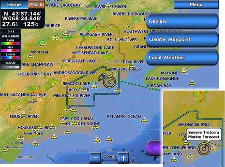
An energetic but somewhat chaotic frontal system passed over Maine last Thursday afternoon but I was able to keep on boating largely thanks to Garmin’s new GDL 40 cellular weather system, which I’m getting to test somewhat ahead of the shipping date. The severe thunderstorm warning that headlined most of the NOAA coastal forecasts might have kept some people off the water. (The forecast areas greyed out on the screen above all have some sort of warning, as shown in the inset, as well as the full text, which can be called up.) But the animated Nexrad precipitation radar, along with lightning strike data, indicated that that my bit of Bay was going to enjoy a frontal hole…
Sure, I could have used other cell-based tools to get the information you can see on these screens. I’m still a fan of the Android app Bluefin Marine Weather, for instance, because it delivers a similar combination of Nexrad radar with NOAA marine forecasts and buoy reports. And I’ve become fond of iMapWeather Plus on the iPad’s big screen, which also offers the two recently discussed GRIB viewers, particularly WeatherTrack’s ability to display storm cell forecasts which seem quite accurate sometimes. But nothing seems quite as complete or handy, especially from my flying bridge, as this service integrated right into an MFD…
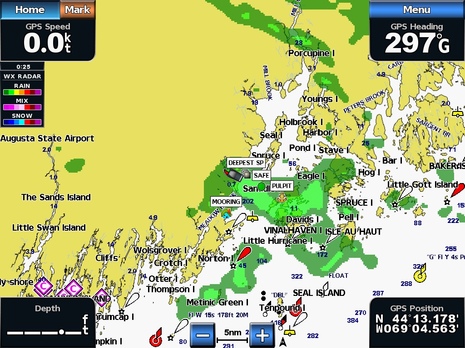
In fact, I wasn’t actually planning to test the GDL 40 on Gizmo last week as I didn’t yet have the antenna mount I want to use. But I had been impressed by some testing I did in the lab — as in the zoomed-in Nexrad screen above, taken a couple of weeks ago — and it was on board Thursday afternoon when the skies started darkening while NOAA beeped warnings over VHF and FM…so I did a quicky install. And again I was impressed with how much Garmin has learned over the years of displaying XM Satellite Weather and how similar this new service is. For instance, you can check out the data on prefigured but customizable weather screens like the one at top, or you can overlay desired info on a regular navigation chart, as above…
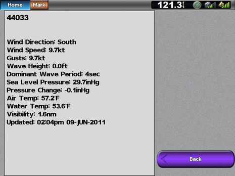
The subtleties often seem right, too. I was recently disappointed to notice that the otherwise good iOS app NOAA Buoy & Tide Data does not display the visibility data generated by my favorite local weather buoy in the mouth of Penobscot Bay. I know that few buoys have a visibility sensor — which is probably why some developers fail to decipher the data field — but, man, it can be useful information when the fog banks are drifting along the coast. And notice that Garmin’s cell weather has it, above.
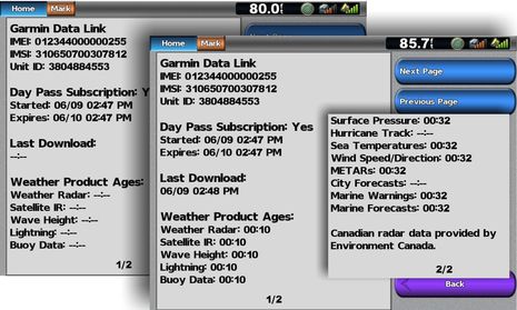
I have not yet carefully compared Garmin’s cell service with XM or Sirius (your observations appreciated) but one thing I know for sure is that it is much faster the Garmin XM I tested last summer, both in terms of downloading data and manipulating it on screen. I remember having to turn on the 7212 at least 15 minutes before I could check XM Weather, while you can see in the screens below that almost all the cellular data was loaded just one minute after I purchased a $5 day pass last Thursday. In part, that’s because the cellular service only downloads an area of data about 625 miles square around your position (pretty much what’s seen on that top screen), which is probably also why the data seems to pan and zoom quicker.
The cellular service can customize what data is sent because the communications are two-way and so the positioned collected from your MFD and/or NMEA 2000 network can be easily send into the weather server. The download speed — most everything in 22 seconds if you read these screens carefully — also suggests that Garmin may be using 3G, though it’s not stated anywhere I can find. It was also interesting that all that data could get from GDL 40 to MFD without any noticable hiccups with the other data passing over the N2K backbone as I drove down Penobscot Bay. I’m still convinced that the GDL 40 can do much more than weather, as I wrote about when it was announced.


I have a Furuno WEFAX on my boat. I appreciate the weather radar loops and the buoy reports both US and Canadian. I still want the surface analysis and the 24, 48 and the 96 hour progs. The 500mb products are very helpful, particularly for predicting storm tracks here on the west coast.
When I went to Alaska last summer on my boat the WEFAX and my iPhone mostly kept me informed. The additional charge for a weather subscription service which just repackages government data which is free. Even Canada gives their weather information away for free.
Now if I had a weather station on my boat that transmitted my weather along with scores of other boats in my general area, which was then used in the forecast models, then I would eagerly subscribe to such a service.
The bottom line for me with weather is in marginal conditions making a go-no go decision. The current subscription based service products just don’t improve much over what I can get for little or no cost. Upgrade your products and you will get me as a customer.
Patrick Harman
Patrick, that’s a very interesting thought about serving as a weather data collector. The NMEA 2000 network on Gizmo includes an ultrasonic weather station, heading sensor, and GPS, not to mention depth sounder — a setup which is becoming fairly common. It would seem almost trivial for the GDL 40 to poll those sensors and report the data back to Garmin for sharing on its service (and hopefully with NOAA), as well as collecting soundings.
I’d like to learn more about how the GDL 40 compares to Garmin’s XM weather box, which I have aboard Sea Spirit. Specifically, I’d like to learn whether there is any advantage or disadvantage to having one over the other. I’d also like to learn whether they both work together on the same network, or whether having both of them confuses the Garmin MFDs.
From the article, it looks like the cellular service brings up weather faster than the XM service. However, I would also presume that the XM service is available much further offshore than the cellular service. Other than these two differences, both of which are significant, are there other differences, perhaps differences in the types of weather presented?
I’m loathe to get rid of the XM box, because of its ability to present weather even when far offshore. But perhaps, if they work together, the cellular box would be a good addition for inshore? Enquiring minds want to know 🙂
Dan
The GDL 40 and GXM 51 Smart Antenna can coexist on the same N2K backbone. With that said I’m not sure I see any value if you already have an XM Weather package using either the GXM 51 or GLD 30 series. If you don’t have either system and you are a coastal mariner then the GDL 40 warrants a hard look. The only draw back I see is the wireless network coverage. I fish extensively in the near to offshore waters of NC. To say the least cell coverage in the area between Cape Lookout to Oregon Inlet is tenuous at best. If you fish offshore or transit to your destinations in the open ocean then the GXM 51 system is your best bet.
As to download speeds to first view, they are heavily dependent on the size geographic area to be viewed (i.e GDL 40 620 x 620 mile box versus GXM 51/CDL 30 North America, the Carribbean, Canadian Martime Provinces displays). The other varibale affectiving initial download speeds is the amount of item data being received (i.e. GDL 40 7 lines of data versus the GXM 51 (master Mariner 21 line of data. Using the GXM 51 the data initially displays as received and some data is a cumlative looped time display of movement (i.e. NEXRAD info, 48 hour forcast etc).
GXM 51 Weather Subscription displays …..
http://i676.photobucket.com/albums/vv129/bluewaterpirate/Garmin%20740%20and%20SH%20GX2100%20Install/21MAY11_1434_00.jpg?t=1306237806
http://i676.photobucket.com/albums/vv129/bluewaterpirate/Garmin%20740%20and%20SH%20GX2100%20Install/21MAY11_1435_00.jpg?t=1306237806“
Can the radar info provided by the GDL 40 be looped?
Thanks, Tom. Yes, the GDL 40 weather service does animate Nexrad. And note that there are actually 13 data types (lines) shown on the GDL screen collage. I’m not sure that the two lists are completely comparable, but I do think the GDL service may be missing the Fishing, Surface Forecast, and Storm Cell Attribute data that XM provides. I’ll check.
I agree the GDL 40 is not meant to replace existing XM set ups and is aimed more at smaller, inshore vessels. But then again if Garmin adds the other sorts of services that seem possible — like monitoring and security when tied up — that’s when it might be useful to an offshore trawler guy like Dan.
That Bluefin Weather App looks great for Android, I must have missed it first time round, but once again it’s US only. What is it with US companies that Europe just gets ignored, do we exist??
Language can’t be a barrier because nearly every sailor in Northern Europe ie Benelux northward Scandinavia etc speaks and reads English well.
So what am I missing here? Why does this happen? any answers anyone particularly from US companies??
Steve
Easy answer. This happens because the government source data is in different formats and/or distributed by different agencies via different systems around the world. So a weather application written to process North American weather data running on a server somewhere servicing Android and iThings, isn’t receiving data for Europe.
While you could quickly name a product that can get you weather data across a large portion of the glove, it is a specific feature of that product that cost time and money to develop.
Thank you Dan for that honest answer, so I suppose what we are looking for is some sort of global standardisation for WX and most other things Marine.
It is such a shame, as Ben works hard to showcase the latest products, and there is some fantastic stuff on here, but perhaps less than 50% of it ever makes it the the EU. really only the big boys stuff. It’s a bit like living in two parallel universes. I dont quite understand the numbers game of it, as there are 1.2 million boats in the UK alone, and perhaps four or five times that in the English “understanding” Northern europe.
I understand that translations to languages for southern Europe could be very time consuming, and maybe not worth it, but hey I watch these products roll by and think, yeah I’d like that, but most of the time it’s not out there, and import duty and VAT and fedex really stack the price up.
Such a shame
Cheers
Steve
Plus, how many European Boaters are willing to spend $13 per day for a weather snapshot service? This is the current cost of this service outside of the U.S!!!
Yes Eric, There seems to be little advantage over getting a 500MB PAYG top-up, and using the UKMO FNMOCS,Meteo France, DWD or Sembach 21OWS sites to get everything you need very quickly.
500MB of data on most networks for 48 hrs validity is about 2 to 3 pounds or less than $4. You can pay a 24 month contract and get 15GB per month on 3UK network for £15.99 about $20 dollars ish. So that makes the 13 dollars a day look somewhat overpriced.
Another point that needs raising, is will it be locked to a certain network provider?. Under EU rules, networks and manufacturers must provide a way for Mobile UE to be unlocked to change networks if requested. Some do it for free, some charge up to £15.
So hopefully Garmin will have recognised this and be providing MNC access via SIM card rather than locked module.
I think this needs working on a lot more for Europe. It smells like a rip-off to me.
Steve