
DeLorme PN-20, first &$?!ing look

Sure, I’m a dite (or tad, dab, etc.) biased toward companies from Maine. I’d be excited about ActiveCaptain no matter where it was, but knowing that it’s home-based right across the Bay likely juices my enthusiasm a few percentile (and maybe the reverse bias is why my Navagear buds seem so oddly tepid on AC?). At any rate, it’s with some sadness that I’m about to skewer DeLorme, even though it’s not only very Maine but also built the world’s largest globe here. How cool is that? So I was pretty intrigued when I realized that the company’s first handheld, the Earthmate PN-20, was also the first ever (I’m pretty sure) to show NOAA raster charts. It’s also one of the first to show multiple cartography types and to let you purchase just what you need, when you need, on the Web. We’re going to see a lot of that model, and I think it has potential merits.
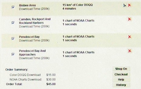
But, man, I’m pretty sure the neighbors know exactly the moment I got the loaned PN-20/Topo USA 7.0 bundle all set up and used the include $100 certificate to buy some local charts and hi res photo maps. What do you suppose DeLorme would charge to serve up NOAA charts, which for years have been freely downloadable elsewhere, and available by the whole inexpensive DVD portfolio? The unbelievable answer is below. That’s ten (10) &$?!ing dollars per &$?!ing chart! I checked the downloaded files and they’re not even reprocessed, just regular KAPs and BSBs with a small added file that I’d guess precludes using your own KAP/BSBs. And, no suprise, zooming and panning them on the PN-20 is quite sluggish. But they do look pretty good, as you can see in this larger photo. And the package has many good features I’ll cover eventually. For now, though, I’m bummed on DeLorme. What were they thinking?


I wonder why DeLorme did not support ENC instead of RNC. Vector format ENC are more compact, scale without aliasing, keep the text and other navaids properly oriented even when using a course-up orientation, support queries, etc.
I am critical of any GPS application that makes one pay for charts that are already paid for by the tax payers.
I agree with you Ben about charging an exorbitant fee for what are essentially free charts.
I do applaud DeLorme for using NOAA charts though. Hopefully they will see the error of their ways, and to the other makers of moving map display GPS’s examine the use of free NOAA charts or some group in a garage somewhere will be your biggest competitor.
NOAA charts are “legal for navigation”, are free, and easy to have up to date charts on board. In a nutshell NOAA electronic charts are the reason I use Coastal Explorer.
Pat Harman
Oak Harbor, WA
Hmmm…sounds like something that is ripe for hacking.
“Oddly tepid”?! I resemble that remark! Actually, I wonder if Active Captain is getting more attention in some regions than it’s getting on the West Coast. I wasn’t impressed with the user-supplied content in Puget Sound or the San Francisco Bay regions, for instance.
But frankly, AC needs some interface refinement, too. I’ve been meaning to contact them privately about this, but I just haven’t had time. I don’t really now, either, so my very quick advice to them is “Read every book by Edward Tufte, and then look at your website again.”
I’m not intending to be snarky here. I really do think AC…or something similar…can become an indispensable asset to recreational boaters.
And my criticism, in this case, isn’t just random, half-baked ranting, like it usually is 🙂 Navagear publisher Aaron and I met in 1994 when we both worked on Microsoft’s Encarta World Atlas, so we actually possess at least a bit of expert knowledge on interface design for geographic reference content.
Ben,
You could have saved some blood pressure by reading my comment (below) to your 4 Jan posting on the Garmin Colorado.
Amazing that they can cram live traffic, wifi & mp3 players into these devices, but still can’t quite manage to display public domain charts natively. Funny how that works; guess they’re just forced to resell you the charts you’ve already paid for with your taxes.
I can guarantee that a no-name Chinese GPS maker is working on this right now; once they hit the market, it will be game over for the proprietary chart boys.
“Regarding the DeLorme PN-20 & NOAA charts, I emailed DeLorme & received the following response from their Sales & Service dept.:
‘Thank you for your email. At this time our PN-20 will only accept information from our TOPO USA 7.0 software. The NOAA charts are the actual scanned charts that have been formatted properly to be downloaded onto the PN-20.’
Guess not.”
“Posted by: JGB at January 8, 2008 6:24 PM.”
JGB, I was thinking something like 50 cents a chart, not unreasonable for reprocessing and providing an easy download system (plus a dite to the bottom line). But $10 a chart? Jeezzzzum.
Just to let you folks know, the reason we here at DeLorme charge for the charts is for the convenence. It is a quick and easy download for DeLorme’s server that is accessed directly through the software that places the overlay in the geographically correct position. We also give a certificate for $100 worth of downloads with the Topo USA software, so there’s 10 free charts right there.
Also, we do make a software that will take any map data gathered from the internet or scanned paper maps and place it in the geographically correct position over the base map using 2 refrence points. This data can then be transferred into the PN-20. The software is called Xmap Professional, and it is a $99 upgrade for PN-20 owners. Just call DeLorme customer service in Yarmouth.
Thanks, Brian
While I haven’t used the Delorme Earthmate PN-20 reviewed here, I recently obtained the latest model, PN-40 SE (Special Edition), with the aim to use it for multiple purposes, including navigation in various distance regattas on Long Island Sound. It will not be the only GPS onboard as the skipper provides a couple of Garmins.
I wouldn’t have acquired this device if Delorme didn’t offer a “Map Library Annual Subscription”. For a $29.95 annual fee, you can download all the NOAA charts (plus USGS 7.5-minute quads, color and black & white aerial imagery) that you need. If you don’t purchase the subscription, you get a $40 credit towards maps which doesn’t go very far when each NOAA chart costs $10.
Although the PN-40 is the same size as the PN-20, it now includes a “dual-core processor” to improve screen re-draws. Onboard flash memory has increased as well, to either 1 GB or 8 GB (Special Edition).
I am still within the 30-day satisfaction guarantee and could return it if I feel there is a better device within this price range. The Garmin Colorado / Oregon 400c come with onboard charts, but there is no included mapping software for the computer. Topo 7 which comes with the Delorme is not very marine oriented (like MapSource is with the Garmin). However, if I intend to use the 400c for multiple purposes, adding detailed land-based maps to either Garmin could be quite costly. From a usage standpoint, one key concern with the Delorme is the small size of the font in the menus which could be hard to read on a sailboat in rough seas, inclement weather, and/or night.