
C-Map Max Pro, a new chart format for a new year

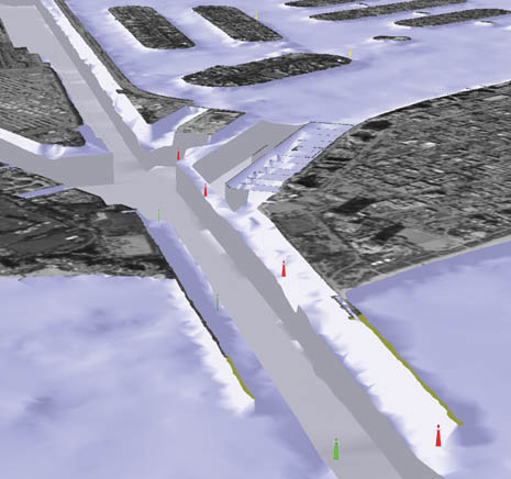
The chart game just gets more complicated, and interesting. There’s nothing on the Web yet, but last week C-Map announced the Pro version of its Max chart format. A couple of weeks ago I got a peek at it running on Northstar’s amazing new 8000i system, about which I will soon tell you a lot. One claim of C-Map is that Pro “delivers the most ‘paper chart like’ display ever seen from a vector chart.” I’m not sure how they’re doing it—new fonts, colors, object arrangement, maybe all of the above—but the charts looked really good. I didn’t get to see the photo map blending and 3D views seen above and below (in company screen shots), but look forward to at the Miami Boat Show where Pro will officially debut. Other features include “one button” chart updating and a weather overlay data system. Of course, all the regular goodies in Max are also included. Pro will be a premium product costing about $390 for ‘MegaWide’ areas, and so far only the 8000i supports it.


I would advise againt using proprietary chart formats. For example my Garmin GPSMap175 unit is still a fine unit EXCEPT for one problem. Garmin discontinued the charts for it.
Instead I advise using the international S57 ENC vector format or BSB raster format with a laptop. Both formats are FREE for US coverage and work with dozens of navigation applications.
I saw the Northstar 8000 at METS in Amsterdam. It looks great and very easy to use. It maybe is 1 -2 years ahead of everyone in the business. Looking forward to seeing it in Miami.
“I would advise againt using proprietary chart formats. For example my Garmin GPSMap175 unit is still a fine unit EXCEPT for one problem. Garmin discontinued the charts for it.”
Name a chartplotter, not software, that can use either S57 or BSB.
As the technology develops they are able to increase the coverage, and add new features. This might mean that current hardware will not be able to use it. It is just the nature technology.