
On The Water ICW ChartGuides, more great work from Mark & Diana Doyle
 My expectations for the recently announced On The Water ChartGuides were high, but darn if checking out a whole 120 page review copy didn’t blow me away (and I’m already familiar with most of the Intracoastal Waterway that Volume 1 covers). The two new ChartGuides are also remarkably inexpensive in print or electronic formats, just like OTW’s other ICW guides. My only complaint? The Doyles are such skilled and prolific communicators that I feel like a piker!
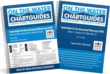 Well, there is potential confusion with the “ChartGuide” name, though it’s just a minor exception to the rule that Mark and Diana Doyle express themselves clearly. Their publishing enterprise is called On The Water ChartGuides, and that worked fine when they first produced the single volume ICW CruiseGuide — which I used religiously during my two Waterway round trips to the Carolinas — and then added the two volume ICW AnchorGuides. But now that they’ve created actual chartbooks (covering the entire southern ICW from Hampton to Miami), their full name seems to be On The Water ChartGuides ICW ChartGuides.
That mouthful, though, is mainly my chance to point out that OTW now publishes three different but complementary types of ICW guides, and to suggest that an easy way for anyone “doing the ditch” to skip possible title confusion is to simply order all five ICW volumes. It’s not hard, given a total cost of less than $50 (plus shipping) for the 5 print editions or less than $25 as iBooks (only the 2015 AnchorGuides available now, rest coming soon 9/10 — they’re all up!). And that’s because OTW became a non-profit in early 2014 with the Doyles picking up all their survey boat expenses while we customers only cover the publishing and printing costs. Wow!
 Now let’s see how the Doyles designed their ChartGuides. First, they managed to fit same-scale north-up NOAA charts for half of the entire southern ICW onto each volume’s 8.5 by 11 inch color pages, and almost every page is in portrait mode so that they’re especially easy to flip through with the wire binding. Volume 1 includes the alternate ICW Dismal Swamp route too, and the image above shows the top half of a DS page. While the chart scale is readable enough to serve for backup navigation — click on image to see larger — the main goal is to provide a visual reference to important bits of info like bridges, danger spots, marinas, anchorages, free docks, etc.
Last fall I traveled the Swamp route for the first time in about 40 years, and I’m sure I studied ActiveCaptain and other sources before I motored down the river to find an overnight berth in Elizabeth City, and I no doubt had the OTW CruiseGuide open near the helm. But this new ChartGuide page would have been a great help as I dealt with the bascule bridge and the apparently full courtesy docks beyond (Jennette’s was great, by the way, and so was E City overall). Note the AnchorGuide symbol for the Pasquotank River on this ChartGuide page…
 …here’s how that anchorage is treated in the iBook version of the AnchorGuide. The Doyles have overlaid their soundings track over the NOAA chart for every anchorage they recommend, and the electronic version includes addittional maps and photos like those you can scroll through on the left “page” above. But except for that special AnchorGuide feature, and despite the crazy number of screens on Gizmo, I like to use OTW’s printed versions. I find paper guides quick and reliable to use underway, and they somehow pair well with multifunction displays.

What’s important, though, is the design not the medium, and it’s hard to beat some of the cartographic extras seen on this partial ChartGuide page (near Oriental, NC). The Doyles put the South Bound boat icon and also the Red/Green mark icons on every page to help remind the user where they are on the chart and which side the nav aids should be on. That itself is helpful, but it works especially well to highlight the multiple times that the nav aid colors reverse (and confuse boaters no end). Also useful are the drawn-in shortcut, waypoint lat/long details, added ICW mile marks, and the “cautions” that relate directly to the OTW CruiseGuide that might well be open next to the ChartGuide.
 While this image shows the regional section naming and coloring style used at the bottom of ChartGuide pages, what may stand out is “too much information!” Thankfully, this is as data dense as Volume 1 gets, and there’s a larger landscape version of the same area on the next page. It’s also a good spot to see how the ChartGuide coordinates with the CruiseGuide.
 Though my photo actually shows a partial page from the 2005 version of the CruiseGuide, the Doyle style was already well developed (and the new 2016 edition looks perfected). Each page puts important regional contact info upper left, next to a rolling list of the particularly important spots you’ll encounter over 100 miles or so of running north or south. Thus you can use the detail presented on the rest of the page without worrying about a significant surprise on the next page. Some of the detail is in the soft narrative style I appreciate in professional guides — crowdsourcing just doesn’t work for this — while the critical factual detail is listed by ICW mile and thus easily cross-referenced to the ChartGuides. In other words, a typical OTW user will already know what they’re looking for when they consult a busy ChartGuide page. It’s a triple-guide system.
 The recommended anchorages’ maps tucked in the back of the ChartGuides and coordinated with the AnchorGuides, of course, are further evidence that the Doyles have evolved from good graphic designers to capable cartographers. And for the same reasons that I like the electronic versions of paper charts, some OTW users may be happy to use the highly designed Guide pages in digital form (perhaps especially on the iPad Pro 12.9-inch screen that will likely be announced on Wednesday.
 The Doyles are deservedly proud about how their existing Guides already fared in an excellent Practical Sailor review covering most of the ICW resources. But let’s note that other guides and chartbooks also got the “recommended” nod and I agree that you can’t really have too much information if it’s well presented. The PS review, incidentally, was put together by the talented Frank Lanier — come on, PS, please use bylines — and I just wish he’d included the relevant NV Charts paper and digital chartbooks, which are a great alternative for checking out all the explorations you can make off the ICW.
 But who the heck are these Doyle people? For decades Mark and Diana have been cruising the ICW and beyond — see their “legacy guides” — apparently working hard most of the time. But now “the ICW is the only geography we work. And we work it hard –not simply pass through it. To produce our guides we marry the latest technology with the timeworn tradition of on-the-water surveying. We revisit locations, taking geotagged photos and recording depths directly into our computers.”
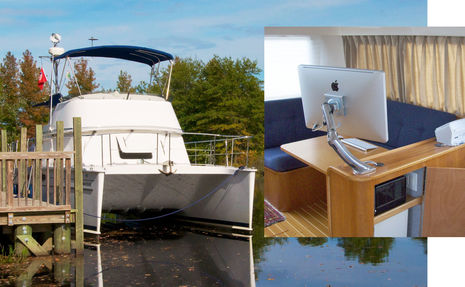
So actually there are a lot electronics behind the paper products. In fact, the Doyles also wrote the most complete guide to electronic charting, though now a bit dated, and then chose to work with Rose Point Navigation (Coastal Explorer) to produce their AnchorGuide track overlays and ChartGuide screenshots. And there’s a whole lot of Apple hardware and Adobe software at work on their able PDQ power cat.
 But one terrific bonus of the CruiseGuide is detailed information about all the bird life you’ll see around the ICW; credit for that goes to Diana, a trained ornithologist who’s also the active founder of Birding Aboard.
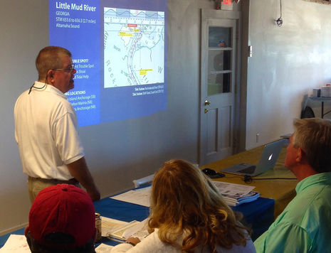 Meanwhile, I’ve learned that Mark is an outstanding presenter and both Doyles excel at organizing events. One regret I have about not taking Gizmo south again this fall is that I’ll miss the Hampton Snowbird Rendezvous they help to produce. And this year the same team including Tom and Cristina Hale will lead the SAIL ICW Rally that they assisted with last year. I happened to be in New Bern, NC, when the inaugural Rally showed up for two days last year, and I have no doubt that it was Doyles and Hales who kept this challenging operation together all the way to Miami. I predict that this year’s event — which will also include Sail’s inimitable editor-in-Chief Peter Nielsen — will be fantastic.
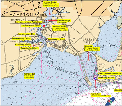
Yes, I do work for the same magazine group that includes Sail, but that sort of thing never colors my reviews. I know the Doyles and their good work. In fact, Labor Day is fitting for this entry, as they work so hard yet seem to love doing it. I’ll finish with a couple of comments on the ChartGuide page showing Hampton. First, that anchorage in the uncharted area north of the Hampton Bridge is great if your boat isn’t too tall, and I discovered that thanks to an AnchorGuide page. But last spring I learned on my own that the Mill Creek anchorage is also good, especially since the new Deadrise seafood restaurant opened above the Old Point Comfort Marina. Many sources equals great cruising.


Impressive, and their prices are basically charity. My cruising area is the Pacific Northwest from Olympia, WA to Skagway, AK. Maybe someone in my cruising are will use their style in my area.
As an aside I would like to compliment Ben about informing about an upgrade to the Garmin firmware that allows .gpx files to be directly imported into GPSmap 547xs. I sure saved a lot of time importing years of routes from Coastal Explorer. Thanks Ben
Patrick Harman
Patrick, I recently started using the Salish Sea Pilot guides. They are well written and extremely reasonably priced at $5.00 ea. http://www.salishseapilot.com/
Thanks for the shout-out and the support Ben! Diana and I really appreciate it … and you definitely ain’t no piker, sir. 😉
These guides and charts have on unique feature that none of the other guides have: they work coming north in the spring. With any other guide it is hard work to back track. The OTWCG are super easy to use heading north! They are the only guide with this ability!
Neato. The new OTW ChartGuides and 2016 CruiseGuide are all on iBooks now and looking good:
https://itunes.apple.com/us/author/mark-s.-doyle/id842686736?mt=11
The careful info design looks a little squished on my 7-inch iPad mini screen but you can pinch and zoom any page anyway. The pages should work great as is on a regular size iPad and will likely look amazing on an iPad Pro.
Incidentally, while I’m inexperienced with the iBooks reading app, I am learning to appreciate its visual table of contents for when you want to flip around in a book like this. Still it would be nice if the OTW guides were also available for the Kindle reading app, which runs well on all sorts of screens.
Yeah, the pinch-and-zoom workaround basically give “Large Print” functionality to us old farts. And as to Kindles (and Nooks), nothing would make Diana and I happier than to be able to get our info onto those platforms … but there really isn’t a good multimedia-authoring app for either yet. I think people should tell Amazon and B&N they need to create a tool for developers to enable rich-content design. Right now each is only interested in semi-plain text, flowable prose, with a few occasional pix or illustrations on the side. Great for novels or cook books but won’t support heavily-formatted, tabular, and/or photo-rich applications. Everyone would like to believe you can just “PDF it” … but that doesn’t work. Or ePub. Plus Amazon has a “delivery charge” built into each book, per MB, so folks wouldn’t be able to afford an Amazon port, even if they had an iBooks Author equivalent. Neither alternative has tooled up for these kinds of guides. The whole market is a mess right now. I imagine it will get better in time but for now, it’s iBooks.
Thanks, Mark. That explains why the Kindle version of Nigel Calder’s “How to Read a Nautical Chart…” is so hard to use. All the illustrations are there, I guess, but not in a form even resembling the good design of the print edition. I thought the problem might have caused by the publisher but now it sounds like Amazon’s fault. Drat!
Yeah Ben, love ’em or not, Apple’s culture has always been about fonts, typography, music, video, and photos, not just pages of dense prose. And charts and maps are basically pictures. That’s why they’re also winning on the flight deck of an Airbus with schematic and tech drawings, aeronautical charts, and the like. They see a distinction in being about multimedia and I think they realized a long time ago you don’t get that for free. They’ve had to bootstrap developers (especially the small guys like us) to make up a compelling ecosystem and profitable revenue generator. The SDKs and tools you get are pretty unbelievable. And development efforts monetize at 3-5x (depending on whose numbers you believe). So if you only have to develop for and support a handful of devices, at a couple resolutions, they win. I know Android folks, or Nook and Kindle owners, don’t like to hear this, but … Not an apple fanboy here, just a pragmatist.