
NV Charts: vector/raster paper & digital, US too
I’ve known of NV Charts for years as a German supplier of cartography for Europe and the Caribbean, but I’d never met founders Cornelia and Hasko Scheidt until this Miami show, and I had no idea that they were expanding into the U.S. with a very interesting model. The Scheidts — whose perhaps-telling business-card titles are Art Director and Hydrographer — are creating custom paper charts based on NOAA vector data with their own survey work added, which they also produce in multiple digital forms, though they’d rather you didn’t use those without the paper versions on board…
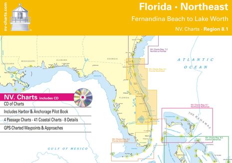
As Hasko puts it, you can get free digitals with the chart booklets, or a free booklet with the digitals, your choice! For example, the $80 16- by 24-inch printed Northeast Florida chart booklet whose cover is shown above comes with a CD of the same charts in a raster format that’s understood by several charting programs, as well as the right to download the same charts via X-Traverse to Apple computers and mobiles running MacENC or iNavX. Now, aside from the latter nicety, this NV Chart bundle is similar to the ChartKit and CD bundles that MapTech has offered for many years (though now under Richardsons’ management), but competition is good and it seems to me that NV has an appealing approach.
I’ve often appreciated the handiness of ChartKits but sometimes find details difficult to make out due to the way NOAA raster imagery is sometimes shrunk to fit page sizes. I haven’t used NV booklets on the water yet, but it looks like the Scheidt’s idea of starting with flexible vector data may be a good one. As is their willingness to go out and survey critical cruising areas. If you read Panbo regularly (or search the site for NOAA), you’ll know that I’ve come across numerous issues with official data, as have commenters (like yesterday’s revelation from Phin Sprague about an uncharted Portland-area ledge streaked with bottom paint and lead). NV Charts apparently runs one survey vessel in Bahamas and one out of Newport, Rhode Island, which has already contributed to their first two New England chart bundles. Has any reader tried NV’s U.S. charts? Or have comments on the company’s existing European and Carribean coverage, paper or digital?


I’ve been using NV charts for Denmark and Germany for years, and I think their business model of supplying paper + digital for one price is really appealing.
The only unfortunate thing is that there are so many digital chart formats, and that NV has seen fit to add a new one. I understand why they did it, but I do wish they’d gone for S63 instead.
I know it’s unpopular to admit but I believe the need to have paper charts onboard has gone away – the transition time was sometime in 2010. I have 6 sets of ChartKits and a full set of Explorer Charts and have always piloted with the current chart open and being followed.
But now in 2011, I’m no longer using the paper charts – the books are away and I’m trying to come up with new storage ideas for my chart drawers. Yesterday was my second no-paper offshore passage. It was delightful to not have to constantly update the paper position and make markings/notes.
This is nothing against NV – I love their charts. I just don’t want them on paper.
Jeff,
Do you still carry the paper charts on your boat? If not, what is your back up for various modes of electric/electronic failure?
Larry H
Well that’s what I realized. How many copies and devices of charts do I need? What failures are there?
I have 4 active phones, all with all charts. Currently 2 (soon to be 3) pads. 4 laptops. Multiple remote charging systems including a nice little New Trent that will keep my iPhone powered for days continuously. That’s about double what most cruising couples have – and I think half that is well enough too.
If GPS goes away, why can’t I do DR on my phones?
If a wave broke through my pilothouse soaking everything, I’d lose half my electronics. I would have lost my charts previously too.
I still have all charts on the boat but only because I haven’t been back home since August. In June when I return, the charts are coming off.
Here’s the biggest thing…
My charts are all about 4-5 years old. My electronic charts? Weeks old. I’d go so far as to say that the risks of using older charts is much higher than any electronics risk you’d face with multiple backups.
Jeff, I have been a huge fan of electonic charts for years, and use them and my backup devices for years. However, I always make sure I have paper charts on board. All it takes is a lighting strike on the boat and all of those wonderful electonics can be fried (although I always stick a spare laptop, vhf handheld, phones and gps in the faraday cage, I.e. oven during lightening storms).
Eighty bucks for charts that are available for free is not going to cut it. Perhaps NVcharts can sell their charts in Europe or Canada where they are competing with overpriced government charts. But in the US, they are competing with something that is available gratis.
The problem with vector charts is that there are many gaps, where there is only raster chart coverage. I realize that NVCharts have a survey boat in the northeast (and one in the Bahamas), but is it reasonable to expect one boat to be able to fill in the vector gaps? I think not.
As for Jeff ditching his four year old paper charts, I am glad that he feels confident enough in the GPS system. I am sure that someday we will all be able to do that. But for now, I will keep my paper as a backup in case something happens to the GPS system. I note that LORAN is long gone, and that Garmin is complaining that one of the proposed G4 systems will interfere with their GPS receivers.
Jeff,
I think that you are well prepared for your boating area. Where I boat in the Pacific Northwest, we are out of cell coverage a lot of the time. Also, the rocks don’t move around much, so this weeks charts are not so important. Most of our boating is done ‘out in the boonies’ so having the absolute latest charting of bouys and markers is less important.
Larry H
I have used NV’s charts for several years for the baltic and don’t feel a need for any other charts for this area. I find them significantly better than their main competitor’s for this area, Delius Klasing.
In fact, I have never read a bad word about these charts.
Any electronic charts can never be better than the software or devices that run them. These work well with Coastal Explorer and they are supported by Expedition as well so no problem in this department for me – though there are no MFDs I have ever heard of supporting these charts (also no problem for me).
It’s also supported by Fugawi which I have not used so far.
Coastal Explorer 2010 beta needs an update, UpdateCE-10111-27.exe I think or any later one, to support NV.digital. The old version 1.1., shown in the shot above, supported it out of the box. From what I understood from Rose Point, CE 2009 doesn’t support this format but it might be worth a try.
I understand the electronic chart format NV.digital is shared by the french chart publisher Navicarte.
I also like the approach of bundling paper with electronic which makes it easy for me to always have a full set of current paper charts. A full set of over half the baltic, covering anywhere I might get to in a 4 week vacation in any direction, a stack over an inch high, is EUR 198. If you return last year’s set, the new one is discounted to about EUR 170.
You can sort of get the electronic charts only, at least that’s true for the baltic sets, by buying a “correction set” which are the electronic charts and small correction prints for various areas on the charts that were changed arranged on A4 sheets of chart paper which you cut and glue. The correction sets for the whole area mentioned above would be about EUR 100. I tried that last year and gave up on the cutting and glueing about one quarter through because I have better things to do with my time and will get back to the full set this season. But if you really only want electronic, that’s a way.
Each electronic chart is registered (activated) to a specific computer and can be registered to one other computer or you can choose their dongle to install them on any number of computers but use on only one at a time. I have the dongle but will go back to per-computer registration as the dongle is your single point of failure right there. Or even just the single point of left at home.
As of last year they offer a “monthly update service” where I get an email each month with a download link to update the electronic charts and a PDF with the correction sheets. I don’t bother with the PDF but always apply the electronic chart update. This is for the baltic sets. I don’t know about the US or Caribbean sets. This service is free during the period in which the charts you bought are current and I consider it a significant value.
They also bundle photo charts which aren’t worth mentioning. I tried Bill Stockton’s ChartAid for this with much better results. ChartAid can now make photo charts instead of BSB charts which get unmanageably large quickly. Photo charts are JPEG compressed. It’s the same format as included with NV’s only you get to choose which area and at which resolution.
They don’t make charts for the north sea coast of Denmark even so the make a set for the adjacent Limjord so I find it weird that they venture all the way out to the US east coast but good for you and maybe for me, too, if I ever make it there.
Their German offices are in the cutest little town covering a peninsula that rivals what I have seen on eastern long island for example.
The one thing I don’t care about too much is the Panasonic Toughbook shown in the marketing shot above for reasons I described in other entries. It was mainly because of their marketing that I bought into this device and I got burned.
I think there are other ways to look at the risks…
First, I don’t completely buy the lightening-strike-takes-out-all-electronics theory. I sort of think that if there was enough current induced to destroy the phone in my pocket, it would defibrillate me, killing me. Additionally, if such a strike took out everything, my engines would be gone too and probably enough water would have infiltrated to destroy the paper charts out on my chart table (pre-giving up paper).
Second, my phones, pads, laptops will all show me my position on charts if there is GPS. If every GPS satellite falls out of the sky, I’ll still be able to view all charts on my electronics. It just won’t show me where I am. In other words, I’ll be in the exact situation I am with paper charts even when every GPS satellite is working perfectly.
Third, I carry no electronics that requires a cellular connection to view charts. While offshore Winyah Bay, SC yesterday, I had no connectivity even with cellular amps onboard. And yet, every electronics device showed wonderful views of exactly where I was, even every mobile phone. I’m not sure where the assumption comes from that you need a cellular connection to view information stored on the mobile phone. It hasn’t ever been the case.
“…single point of failure…or even just the single point of left at home.” Nice turn of phrase, Henning; thanks!
Say, Rick, where are you getting free U.S. paper charts?
Perhaps I left the wrong impression. I have 3 year old paper charts that came with the boat. The only free charts are electronic ones that I downloaded from NOAA. I feel confident using old paper charts since they are only a backup to up-to-date electronic ones.
RE paper charts of US:
I bought a little plug-in for Photoshop that will read the BSB format.
I then save the result as a .tif and plot it from Illustrator using the same plotter used by the charts on demand places.
Note that this would probably not be cost-effective if I had to buy the plotter just for this purpose, but as a designer I had it anyway.
You need both a cellular connection and gps signal to use a smart phone or iPad with electronic charts unless you have taken the time to download all the charts you expect to need. While GPS signals are readily available for plotting, the chart itself reguires a cellular signal to download the chart info. Otherwise you will have your exact location plotted on a blank screen.
Re value of paper charts, it is easier to make notes, you don’t have to scroll around and you can have several paper charts of different resolutions “open” at the same time, which requires several monitors to do electronically. While having electronic charts makes plotting position, course, and speed instantaneous, I prefer to retain my old navigating skills using paper. It is a dying art, just as is talking on the phone in lieu of texting and sending invitations and thank you notes via email rather than paper cards.
Anyone who is an IT person, knows that 100% dependency on electronics, needs to always have a backup plan. Mission critical applications as in hospitals, have paper backup plans for the 1-2 hours per year their computers may go down. And they have backup computers, back up emergency generators and remote storage backup as well, yet still have a paper option for catastrophic failure
Agree with Jeffrey.
Was just thinking what I have on board
Simrad NSE with full west coast charts.
Garmin 420 with same
Garmin GPSMap 60SX with same.
Macbook with MacEnc with Vancouver Island charts.
Lots of backup…and like he said….you can DR with electronic charts.
Jeff,
In the last three years, we’ve had three friends hit or near missed by lighting. All electronics including cells died. All boats had more than $60000 repair bills each. All crew hearts functioned fine after initial fright from the lightning and shock from the bill. Marine installers around Tampa-St Pete and insurance companies have plenty more examples. Defibs deliever 100-360 joules of biphasic DC.
Electronic charting is great. I love it, but it isn’t 100% reliable under environmental stress. Prudent mariners will always have paper, pencil and education in their toolbox.
We keep our HH GPS and cell in a Faraday box when not in use.
Keith – my iPad has never had a cellular connection and yet it has every chart in the US on it. When you purchase a new chart, you have to transcribe your “notes” each time – a very error prone process. When I get new electronic charts every few weeks/months, my notes move across automatically. My notes are by position, not chart, eliminating the scale issue completely.
For most of my career, I designed, developed, and manufactured medical devices. There are 9 FDA approvals with my name on them. There is no paper backup required for any FDA approved device or in any hospital. There is a single-point-failure mitigation requirement that paper backup can be used for, but there is no requirement that it must be paper. Looking at the IHO shipping carriage requirements today is more appropriate anyway – there is no longer any requirement to carry paper charts onboard the largest tanker sailing the seas. Think about that.
Alex – you don’t need that much current to stop a heart. All of my hardware designs were for cardiac products (EKG’s and defibrillators). Stories about cell phones getting destroyed by lightening are always “I know a guy” stories. The same debate has occurred on multiple forums. I’ve yet to see anyone say, “I had an untethered mobile phone that was destroyed by a lightening strike” through numerous challenges I’ve made. Can anyone here make that claim?
Jeff,
All three boats I referenced were not hearsay. They were members of our cruising club. All three owners debriefed us on what had happened. All three phones were on 38-40 foot “protected” sailboats. The devices were turned off. The events were in Spain-GSM, Delaware Bay-CDMA, and Elizabeth City-CDMA.
One cannot criticize “vulnerability” anecdotes without supplying “robustness” statistics.
And as long as Active Captain and other apps/services are accessible/usable on a device that’s functioning, I’ll use them, but I’m not going down the modern path of depending solely on electronics and rescue/towing services.
I agree with Jeff. [gasp!]
I will carry paper charts because I like them. It is easier to discuss navigation with someone else when you have a big piece of paper to point to, but I no longer believe they are essential.
I no longer believe GPS can be turned off short of an act of war.
I experienced a lightning strike ten years ago, and have kept electronic backups in Faraday containers ever since. I know this approach is successful.
Most importantly, I believe old paper charts are the real hazard. Electronic charts can be updated easily, but paper must be replaced, especially after every hurricane. It doesn’t happen. The only thing more frightening is me reaching for my sextant.
While it is true that IMO no longer requires paper charts onboard, there is more to the story than that. In order to be paperless, a ship must have 2 COMPLETELY redundant ECDIS systems (including power supplies). I would also hazard a guess that even if a ship meets those requirements, most Captains would carry paper charts.
Pleased to report that an article I wrote about the end of paper charts way back in 2002 is still hanging out online:
Practical Navigators
Olde Salem, Massachusetts, meets the paper(chart)less future.
http://www.powerandmotoryacht.com/electronics/0602electronics/
Personally, I like to have paper charts around because I find them beautiful and still very handy for general planning and discussion. It’s still hard to beat our eyes and a large sheet of paper for easy, fast panning and zooming!
But I think we’re way past the time when paper charts are an absolute requirement. You can navigate competently, or incompetently, with them or without them.
> All three boats I referenced were not hearsay.
> All three owners debriefed us on what had happened.
But Alex, that is the DEFINITION of hearsay. There’s a reason it isn’t considered evidence in a US court of law. Specifically, were the mobile phones tethered in any way? Where exactly were they? How close to other communications devices were they placed? Were they in contact with a person at the time? Were they contained in any way?
The reason hearsay isn’t legitimate is because there is no way to cross-examine the statements. In questioning, the truth usually emerges.
Sandy – it’s OK to agree with me! We’ll find other things in the future to disagree on! 😉
Jeff,
You have something to sell, and I respect that. I have a business too. Good luck with yours.
Signing off.
I don’t think that’s a fair shot, Alex. Jeff may be opinionated and argumentative, and even down right irritating sometimes — I know, as I’ve been the target occasionally — but I don’t think he modifies his opinions to his business plan. In fact, it’s the other way around.
Interesting article, Ben. What I took away from it was the that the Navy will be equipping paperless ships with bullet-proof systems (lightning, unlike for us, will be the LEAST of their problems), even more robust than the IMO requirements and far, far out of reach of everyday boaters or cruisers. NV bundling paper charts with their digital offerings just makes good sense. For me anyway, the fact is that when all is said and done, our consumer electronic systems are fragile, not designed to withstand the environment we often find ourselves in and certainly not justification for not carrying paper….especially when it really isn’t that tough to do.
Ben, perhaps. Certainly the world is full of opinions, and I’m glad to live where they can be expressed. It is my opinion Jeff’s evangelical ecomiums for all things tied to his business model is approaching infomercialism.
I started out on mainframes in the ’70s and have spent a substantial part of my career focused on how to electronically destroy bad folk’s electronics. When I leave port there is a laptop, HHGPS, and a cellphone in a Faraday case and paper charts in the nav station — and, yes, I have the paper manuals for devices that may require them.
I enjoy the benefits electronics, but as you well know, they come with new responsibilties not total escape from old ones.
I don’t understand why it has to come down to personalities and perceived motivations. My realization that paper charts aren’t needed on my own boat has nothing at all to do with ActiveCaptain. I never brought it into the argument and it wasn’t on my mind at all.
Why can’t a debate or argument center on the facts? Why does this personal crap always have to come into it?
I never said that everyone else must remove all paper charts from their boat. Everyone is welcome to pilot their boat by whatever means they want. I just came to new conclusions myself about DR, redundancy, and currency of data over the last few months and realized that for me, the paper was the risk. It seemed pertinent to Ben’s posting.
That said, I’m an entrepreneur and an incredible believer in the things my company creates and provides. I will never apologize for enthusiastically promoting it wherever appropriate.
I too have to come to Jeff’s defence. I am sorry to see personalities brought into the discussion. What has Active Captain got to do with using paper charts?
I sometimes think that Jeff is out to lunch on some of his ideas, but he is clearly on the cutting edge, and we can all learn from what he and other experts post here.
I had a set of NV Digital charts for the Western UK, bought for me for Xmas and I would like to register here, how disappointed I was. Firstly they did not come with a Guide Book or Paper Charts as all the other sets do, and this is not stated on their website, they are three times the Price (for the whole UK) as Maptech, and six times the price as Memory-Map (Evo). They are derived from Imray Charts, and the update cycle is particularly slow, these “new editions” from Xmas were in fact not updated Charts, just a load of very bad NM’s with HTML links to the main Imray NTM’s site stuck on top of the 2006/7/8 charts as little red exclamation marks.
Extremely poor value for money, when you think that the whole of the UK is going to cost you €300 + shipping, compared to Maptechs £99 and MM’s £39.
And I still didnt get the paper, so have had to buy separate updated Adm charts for my area for that.
The imaging is bad on the charts, with a washy over-antialiased effect and contouring is poor.
The ONLY thing in their favour is that they do have some nice little chartlets for the Irish Republic that the Adm doesn’t have, but elsewhere the scaling is much worse than equivalent Adm derived data.
I wonder if these “Nice People” would like to meet me at Southampton BS later this year for a little tete a tete?..perhaps not I fear.
Steve
Also in answer to the post further up the thread, Coastal Explorer does use NV Raster data quite happily, but unfortunately does not at present provide a quick way of separating the things out of the main quilt, so I have a mess of Adm and NV charts.
But it’s not RP’s fault that the NV charts are simply not good enough to stand up in a quilt of Adm rasters.
Steve
Folks,
It has nothing to do with personalities. I disagree with anyone who suggests it’s responsible behavior to leave port without paper charts. Doesn’t matter who it is. Jeff just happened to be the most persistent voice in favor of what I consider to be bad practice for prudent mariners. And I still believe his assertions as to mass market consumer electronic systems reliability under environmental stress are unduly hopeful.
Simple as that. Sorry for the offense taken.
Having my ideas considered to be “out to lunch” is one of the most complementary things that could ever be said to me. Seriously.
Back to the debate. Perhaps there are different types of cruising and different needs. I fully admit that the longest offshore passage I’ve ever made was about 500 nm. It’s hard on 2 people and my wife isn’t interested in doing a double overnight again. We now do a couple of 250 nm passages a year, usually within 15 nm of land. An open water passage to the Bahamas (and someday Cuba) would be the exception away from land for us.
If I were going to Portugal, I’d probably want current paper charts. But for most coastal cruisers – easily 98% of cruising boaters – I believe the current ways that paper charts are used actually adds danger and risk.
We have the enjoyment of being invited on many boats during the 9 months a year we’ve been cruising recently. We speak at many rendezvous (Emergency Medicine Onboard over the last 2 years) and often meet others because of the AC logos on the sides of our boat. What I find is always the same. If paper charts are even onboard, they are never current. Often they are 5+ years old.
Now I know that on all coasts, rocks don’t change often. But buoys do. Shoaling does. Inlets change substantially. And those are the major DR items that most skippers, if they can even do DR any longer, will aim at. So having a more reliable media (paper) that provides an inaccurate picture seems like it’s only providing a false sense of security – the most dangerous risk of all.
Electronic charts, on the other hand, are simple to keep current. Over-redundancy mitigates loss and risk.
My first words in this debate were, “I know it’s unpopular to admit…”. For some reason, having paper charts onboard seems like some type of badge of honor. I just think that its time has passed.
I wonder how many people who feel compelled to carry paper charts drive long distances with a road atlas today. I wonder how many 25 years olds even know what Rand McNally is or have ever bought a paper map. And just like there were probably people who cursed the new kids for giving up their sextants, perhaps we’re just the next generation who are giving up paper charts.
Progress is never easy and is always a challenge to the entrenched.
There is an old nautical saying regarding grounding, “There are 2 types of sailors, those who have gone aground and those who have lied about it.” I predict that its update will substitute “Lost their electronics” for “gone aground”.
Dear Jeffrey,
I acknowledge your experience with medical devices and FDA requirements. As someone with 30 years experience in critical care units at Cedars-Sinai Medical Center, TJC requires that all medical devices need frequent testing, calibration, and written policies in event of failure. There is no such monitoring of personal on board navigation equipment and it is up to the due diligence of the “captain of the ship” Also, having been on Navy and Coast Guard vessels, I can attest that their diligence in fact, exceeds ours in the hospital environment.
I can also attest that as technology has expanded in health care, so has errors related to such (read about the CT scan overdosing at Cedars-Sinai and other hospitals) and I have had many times that technology has failed and we have had to rely on intuition, experience and good judgment to continue the critical care of a patient. And it all works out well in the end.
Re your comment on no need for paper backup, that is true for medical devices but not for CPOE or an EMR. Emergency backup procedures always involve paper.
We have redundant generators, mirror computers, offline backup in event of earthquakes 500 miles off site (not a problem on the water!) and we still have times when we go down for minutes to hours.
Over dependence on IT solutions, will always have its day of reckoning.
I must point out that while Jeffrey may be “cutting edge” and an “expert” in terms of conceptualizing and marketing an electronic recreational marine guidebook, there exists absolutely no evidence that the same can be said for his marine navigation experience and or skills. To cite him as such just gives him credence where none exists.
This has nothing to do with him personally at all and if he chooses to sail without basic nav equipment, thats his choice (as I think he said) but it certainly doesn’t mean it’s a good practice to be adopted by all. I wish him nothing but luck if for no other reason than his success at electronics only operation means nobody will be put at risk saving him.
Keith, I respect the CCU work you do at Cedars-Sinai. CS has been one of my biggest customers over the years. As a licensed and still active EMT for almost 18 years, I know how hard the work is that you do.
But as someone who has designed calibration circuits for patient monitors, the reason biomedical devices need calibration is because they work in an analog world, converting it to digital. That conversion is where calibration lives and it doesn’t exist in the chartplotter world. I don’t need to re-register/calibrate my charts every few months. No one reading this has ever had to do that.
Second, even the most casual listener to news in the last 20 years has heard a multitude of stories about how paper medical records caused the wrong leg to be amputated, patient overdoses, and many other gross errors to occur. We’re told over and over that electronic patient records will save money AND reduce errors. Do you really want to compare the reliability of today’s electronics against the handwriting of the typical physician?
Third, Cedars-Sinai is the poster child for CPOE failure. Surely you were there a decade ago when they decided to develop their own software for CPOE (a questionable move for any hospital IT department to undertake). After $30 million and threatened walkouts by staff because it was so bad, it was scrapped going back to paper. I’d bet that experience left a bad taste about electronic records for you. But perhaps it was really all about the specific implementation.
In my case, I spent a decade developing products to move medicine away from paper and especially film. Those experiences and the many phone calls about lives saved gave me a different perspective about how technology can make a difference ultimately producing solutions that were much more reliable.
Ben, if you think I’m opinionated, argumentative, and “even down right irritating sometimes” now, you should have seen me in my younger, medical device days! This is the calmer, gentler Jeff v2.0.
Ha! One of my favorite new aphorisms, source unknown: “Old age is a high price to pay for maturity.” At 64, I must be at about Ben v3.2, aka almost-no-drama-Ben.
Now, how about we go back to a discussion of Charts NV? Seems like a lot of readers are fans, but Steverow reports a very poor experience with NV’s UK offerings. An anomaly?
Steve:
So here they are the first bad words on NV charts. I fully believe them and this means that I will steer clear of them when one day we get to the UK south coast as we plan to. Thank you for this information and you have saved me money and aggravation.
I think this also underlines that it helps to be able to easily move between chart publishers which is:
– between hard and impossible with an MFD
– possible with charting software to an extent
– pretty well possible when you buy, configure and learn more than one charting application
– perfectly easy with paper charts.
Re quilting in CE: If you display the chart portfolio and list by details there is a check box for each individual chart “include in quilt”. So you can remove bad charts but it is certainly cumbersome if you have hundreds installed. There is no way that I know to exclude all charts from a certain publisher and this is probably because the publisher isn’t even shown in the chart properties. The properties only show File, Name, Scale, ID, Depth Units, Sounding Datum, Type, Datum, Projection, Source Edition (the year) and an Updated date.
About paper vs. digital:
How about some “what does this mean for the average boater?”
I think the questions discussed here are:
– Do you need a backup for electronic navigation?
– If so, does this mandate paper or can the backup also be electronic?
(It seems to me that this is an important departure from the usual discussion about “which is better?” and I like that.)
Electronic:
I tend to trust my computer not because I think that it will never fail but because I think the chances are that I can fix it in a matter of a few hours. However, in the last two weeks only I have had two serious computer problems.
No 1: PYI Inc. has new hardware for floorboards making them removable without tools. I stupidly typed www dot seaview dot com (DON’T GO THERE! The correct address is http://www.pyiinc.com) and I got infected by a virus the moment the page loaded. The computer was fully patched, had a virus scanner and so on. My mistake is most likely that I use a local administrator user ID. I have known that to be unwise for years but never gotten around to setting up a new user profile which I expect to take a day or two in my case. I had a 5 day old backup of the partition plus a synchronized copy of the documents that I worked on so I lost almost no work but still it took me 3 hours to get back to where I was before the virus and it disabled my computer.
No 2: The disk failed in the computer that my client handed me for my professional work. I also had a backup of my work but I lost time waiting for a and setting up a new computer.
Being in the IT industry I could go on for hours about personal computer failures and even some high profile failures in the finance industry costing incredible amounts of money and bringing one of the largest German banks to the verge of failing but I really don’t think that’s pertinent here.
The point is: Sometimes they fail and this was just the last two weeks. And MFDs also have hard disks.
Paper:
I remember a poll by a yachting magazine among participants of the World ARC where one party reported spending in excess of EUR 20.000 on paper charts for the circumnavigation making this their single greatest expense item. They spent more money on charts than they spent on food including dining out!
I know I can’t do this and I know that I didn’t want to even if I could. Someone else estimated that all relevant charts for a 6 month circumnavigation of the Baltic would make a stack a full two feet high.
Quite obviously this isn’t the solution either for any significant voyaging but it’s OK for home-based weekend and vacation trips (1 inch in my case and this fits easily in the nav table).
I only had one occasion where my computer failed while underway in the boat. On a blustery day in a hard gust the unsecured laptop slid from the nav desk and fell across the cabin. I had the NV paper charts mentioned above on the salon table in their plastic cover (Trust me! I’m not lying!) and they also slid down next to the computer but unlike the computer they continued to work when I picked them up 😉 I now keep the computer in the nav table next to the paper charts.
My personal choice is/will be:
– A laptop computer with two navigation packages and all the electronic charts that I like and can afford (probably CE and SeaPro which supports Admiralty raster charts, Expedition if I can afford it)
– A weekly partition copy to a couple of USB drives and a spare 1.8” hard disk at hand (this is wise to do no matter what you do with the computer)
– for longer voyages, another laptop (my wife’s) turned off and in a waterproof case when underway, set up with the same software and charts, used for DVDs and music when at anchor; same make so you can swap power supplies; swap the computers each week as part of the backup routine
– no dongle for licensed charts but licensed to both the computers
– try to avoid loss of electrical power just as much as you try to avoid a MOB
– a reasonable collection of paper charts, no more than 2 inches for the Atlantic circuit
– for each larger area (the Azores for example) get one large scale chart covering the whole area and one approach scale chart for the single (main) harbor in the area (like Horta, Faial). You will need them only if the above computer setup has failed and that means that you have been knocked down shipping a ton of water or are out of electrical power and in that case you will want to dispense with the slow coastal cruising and go right to the main port with the best repair facilities.
Hm, I have to admit it was a while ago that I looked at the exact offerings that NV has, and whilst they may reign supreme for the Baltic, their other offerings may indeed not be as good.
For instance, for their Baltic paper series 1 thru 4, including the digital version, you pay € 199, which to me is good value. See http://www.hansenautic.de/index.php/cat/c333010_N-V–leisure-charts.html
Now today I checked X-Traverse, and for the Dutch coast you also pay € 199. That’s more than the paper charts that they claim they are based on, and it doesn’t come with these!
Furthermore , that same € 199-from-a-normal-German-distributor is $376 from X-Traverse. Now I know the $ to € rate is going up and down all the time, but this is pretty extreme.
Interestingly, I couldn’t find their UK charts on X-Traverse, so maybe they realised that the quality wasn’t there.
Dear Jeffrey v2.0
I do not think you are opinionated. That is a term we all love to use when debating with someone who is more knowledgeable than ourselves! And I enjoy Panbo because the majority of participants do not resort to profanity, personal attacks and demeaning comments unlike other blogs.
I fear though, we are trying the patience of Panbo readers and Ben by carrying on a medical discourse. So I will confine myself to just a few more sentences.
1. Your comments on calibration are true and I acknowledged your points on this matter.
2. Wrong site surgery has nothing to do with record keeping. It is now avoided by a “time out” in the operating room and having the patient place a large “X” on the correct site of surgery preoperatively. There is no electronic confirmation of this. This is analogous to a paper record in fact.
3. There is not a single peer review publication that documents improved quality of care or physician improvement with electronic records. What it does document in increase physician time spent charting.
4. I can record observations on a chart much faster than electronically. (I type 70 wpm)
5. The failure of PCX was $45 million, I was the CMIO for the Dept of Med for that project and now helping with the implementation of EPIC at CS. I am not computer phobic, just the contrary, but also as a result very aware of all the pitfalls.
So dear readers and Ben, what we really need is a “controlled trial”. Twenty of us use only paper and see how it goes for six months, monitoring all sorts of data-time to plot course, safety issues, etc etc and twenty of us use only echarts. But those using echarts, please have a paper backup. 🙂
Does anyone ever print out charts from their electronic system? Typically you would be using legal sized sheets of paper from an ordinary desktop printer. But the charts would be up to date and they might have your planned route marked on them along with other annotations. The projection is unlikely to be ideal so some care might be needed in using them. However they would be a back up in the event of a biblical electronics failure.
Simon,
Yes, Depending on the application it may require a little attention to scaling errors and works best with 10# card stock and waterproof photo ink. We spend about $200 a year on ink and paper.
Earlier in these comments Jeff mentioned never having had proof of a mobile (cell) phone being fried by a lightening strike when it was stand alone (un-tethered etc.).
I can give a first hand account, though on land, not at sea. In August 2007 I was at our local village cricket ground helping with the refreshments. My handbag (purse) containing my phone was in a cupboard under the sink. A sudden rain-storm stopped play and everyone crowded into the pavilion just as lightening struck the building. Most of the wiring was destroyed and there was a small fire at the circuit breakers. A few hours later I realised that my phone no longer worked. Taking off the back to check the battery there was a faint smell of burnt plastic. I can only surmised that lightening induce
Simon:
I did think of this but can’t really offer much information and would also like to find out more.
– The Coastal Explorer print feature just prints a portion of the chart with only a “1:25.000” scale information in the lower left corner but no coordinate grid and no margin showing nautical miles. This might help if you have closely spaced navaids to work with but I guess you couldn’t call this “navigating” since you couldn’t plot a position on it.
– You would want a color laser printer as prints from an inkjet dissolve incredibly fast on water contact
– I have heard about a company “Bellingham Chart Printers” at http://www.tidesend.com from Shaw Island, WA that makes, sells and ships black and white copies of official current US navigation charts which is supposedly legal with US charts. This may be fine in the US but not elsewhere.
This idea might work if you have a means to print from electronic charts that you own (raster or even vector) in a format useable for navigation right there on your boat and you would discard the prints as you leave each area during a long voyage (giving them away certainly wouldn’t legal). If you tried to improve useability with larger format prints and better paper you would soon appraoch the cost of regular paper charts and you would have a weight and storage problem.
But I don’t have high hopes that a good printing feature exists in any common charting application that reads the format that I want as this would just be a lawsuit waiting to happen for the vendor (either by a user having grounded or by the publisher of the chart data) and would also incourage widespread circulation of the printed copies.
My post was trubcated, operator error, sorry good people. Here’s the whole post.
Earlier in these comments Jeff mentioned never having had proof of a mobile (cell) phone being fried by a lightening strike when it was stand alone (un-tethered etc.).
I can give a first hand account, though on land, not at sea. In August 2007 I was at our local village cricket ground helping with the refreshments. My handbag (purse) containing my phone was in a cupboard under the sink. A sudden rain-storm stopped play and everyone crowded into the pavilion just as lightening struck the building. Most of the wiring was destroyed and there was a small fire at the circuit breakers. A few hours later I realised that my phone no longer worked. Taking off the back to check the battery there was a faint smell of burnt plastic. I can only surmised that lightening induced current was the culprit. I realise that this is not proof positive but it’s good enough for me.
Ben, you’ve made my day, here was I thinking that you were younger than me, but at 56 it seems I’m a spring chicken. But most mornings I certainly don’t feel like it.
Henning, very nice post, and yes, you will be wasting your money if you decide to use the NV/Imray charts for the UK. I agree that their German and Baltic charts are stunning, but that does not seem to translate with other data providers such as Imray.
Also there are substantial problems with areas coverage, that I did not mention in my post. For isntance if you decided to investigate the River Exe, which is a popular sailing destination and wild bird reserve and a SSSI (site of special scientific interest), you would find that the NV charts only go as far as Exmouth Dock, completely ignoring the rest of the River Exe, which goes on up river to Starcross, Topsham and beyond via the Exeter Canal to the Medieval City of Exeter, and many international boaters, like to come up here to see the Unversity City and also take in a visit to the Met Office which is based here. My boat was, for a little while, berthed at Topsham and it was a good job that I had Maptech Adm charts, as the tidal navigation up river is somewhat challenging to say the least.
OK on CE, no probs, it is the best program out there, wheras you prefer to run it alongside Brians Seapro, I prefer to do the same, but with an old version of Maxsea 10.3, which gives me the charting facilities that CE doesn’t yet have (but will) and a slight extension in the availability of charts.
There’s nothing wrong with Seapro it’s just that it doesn’t work “naturally for me” in the way that CE does. I’m not keen on a program that you cannot immediately pick up and pan a chart.
As far as the problem with selecting different sets of rasters on CE, yes it is a bit difficult, although there is a method of clicking at the top of the list and then at the bottom and using the spacebar to remove anything in the middle..er if you see what I mean. RP are aware of the issue, and I expect at some point in the future some hierarchical file structure to do this to go in there. We must also not forget that due to circumstances well beyond Rose Point’s control, that CE 2009 was never released into Europe and so they don’t have recent experience of Euro only problems like selecting different raster sets. That is not to say in anyway at all that the product is not good for Europe, it is, and I love it and can’t wait to see it released and do really well over here like CNP did.
I should also say that NV don’t help the situation at all, by it’s auto install procedure which is hell bent on installing the NV Charts into the Maptech Chartkit/BSBChart folder. I’ve tried putting them into their own folder, but they will not read from there and I don’t know why.
With Ben’s permission, I’ll perhaps send him a few screen shots to put up, which highlight the problems, but please don’t take the S/S’s as a measure of quality as it can’t duplicate a real screen.
Kindest Regards to All
Steve
As for the issue about paper charts versus ECS, I dont want to ignite an already well worn topic on many fora over the years. Suffice it to say, it’s not illegal over here to use Electronic only, but it is frowned upon in the UK, and is a definite no-no in more beaurocratic countres like France and Spain.
The official CG line here is, that they like to see paper as well, with a cross reference from ECS to paper every thirty minutes. All sailing courses here, which although not Mandatory, are “encouraged” very heavily, teach traditional navigation first, and Electronic Nav as a sort of add-on module.
You must have a minimum of an ICC to sail to countries like France Spain, or to use the extensive Mainland European inland waterways.
If you have a bump or a navigational accident here, and do not have paper on board, one is likely to get an extensive ear bending from the Coastguard, and also in some circumstances a refusal to pay up from you insurers. Oh yes and don’t drink alcohol whilst in command of any vessel, big or small, as that is now illegal here too, and you can, and will be, breathalysed and treated as a common criminal in the same way as a drunk driver.
Steve
Another issue is that the NV’s do not come with any tides and currents at all. And as usual as KPM/Maptech have not yet got their act together on T&C’s for the UK a full two months after the last lot expired, I dont have any T&C’s for CE so have to rely on my Android with Navionics and VisitMyHarbour.
I often just feel like putting my hand up and saying..Hello…yes it is us over here, you know the old country, the peeps who gave you Radio, TV, Radar, Sonar, AIS, Navtex, Tarmac, Slavery, Railways and lots of other nice and not so nice things, but it just falls on deaf ears I’m afraid, at least as far as Marine Charts go. Talk about a raw deal.
Steve
Fishwife – I know you think it was a good example. But I don’t think you could have set up a worse risk of attracting dangerous current into your phone than setting it beneath the sink. I’d assume there was copper piping in close proximity. Those grounded pipes had a much lower resistance than the wires you said caught on fire. All of those electrons jammed onto that pipe were looking for somewhere to get out. Tell me the sink was a large metal basin and you’re lucky no one was killed in that kitchen.
Steve – your wording is very nebulous. Going without paper is “not illegal” but “frowned upon”. “In some circumstances a refusal to pay”. “They like to see paper”…
What does all of that mean? They’ll give me an “ear bending”? Come on – either it’s allowed or it isn’t. Either insurance covers the actions or they don’t.
For what it’s worth, we were boarded by the USCG this week. They gave us their highest, perfect score for inspection in writing and spent a good part of the time playing with our dogs – even took pictures and ended up commenting on our blog:
http://takingpaws.blogspot.com/2011/02/visitors-underway.html
No paper charts out at all. The only thing that was bending was our dog’s tails.
Jeff,
I realise that there are vast cultural differences between us, although because of our common heritage we are in so many ways so close. However, your term Nebulous is quite perfect for the seagoing rules for Leisure Vessels in the UK. The system works very well, by a system of “Voluntary Compliance” without the direct need for government intervention to take away that last bastion of freedom, ones own inalienable right as an Island Nation to take to the sea on a telegraph pole with a paddle if so desired. The fact that you will probably be brought back by either the Navy/CG or RNLI and sent off for very gentle Psyhco-analysis, is not relevant. The fact that you “can” do it and that right is still there says it all. You would really need to live here for a few years to understand the social intricacies of it all, but suffice to say it works well and is achieved through a combination of light government regulation, Voluntary organisations and peer pressure to comply with navigational safety, much of it achieved by implied “tacit” unwritten rules.
It is not dissimilar to your misunderstanding of the term “Captain” when applied to Europe and the rest of the world. That term can only be used here for someone who is a four bar pro. Usually a master mariner, or Fellow of the Royal Institute of Navigation. It’s a professional rank, equivalent to that of Doctor, lawyer, Architect, Vet, etc etc.
To use it here in reference to Leisure mariners is deemed offensive, and would only be used in that context in a derogatory fashion. Leisure Vessel owners are universally know as Skippers, and sometimes the official term “master” is used meaning anybody who is in charge of a vessel at that particular time. These tacit “understandings” are not just in use in the UK, but also mainly across our close cultural cousins in Scandinavia and Northern Europe and of course also Oceania. The further south in Europe that you go, the more Direct Government regulations come into play.
For more legal info then visit the RYA website here:
http://www.rya.org.uk/infoadvice/regssafety/Pages/default.aspx
And also the MCA website on “recommendations” for recreationaol craft is useful.
Cheers
Steve
For anyone in the UK or US/UK carib and other international destinations,interested in printing out paper charts the best option by far, is to go to Steve Bryant’s [ http://www.visitmyharbour.com ]
website. He has all the tools for doing this and the image quality is stunning.
Steve
More fuel for the paper-versus-digital debate:
FAA approves iPads for pilots’ electronic charts
Steve:
Thank you for this helpful information.
I believed that “Admiralty Raster Chart Service” (ARCS) charts are the only electronic form of Admiralty charts and they are not supported by CE but only by the original (not Time Zero) version of Maxsea and by SeaPro.
You mention “Maptech adm” charts and on http://www.maptechnavigation.com ist says “High resolution Raster Nautical Charts (RNC’s) reproduced from British Admiralty charts * BSB4 format for use with maptech and other manufacturer software”. Does this mean that the same charts offered as ARCS for a lot of money are also available at USD 149.95 for the whole of the UK and Ireland and in BSB format? If so that sounds like a good deal.
What are the charting facilities that you use with Maxsea 10.3 and CE doesn’t yet have?
I am looking at SeaPro as it has support for the Koden radar which it looks like I will get. From the screenshots on http://www.euronav.co.uk I already got the impression that a slick intuitive and moders user interface is not one of it’s strong points but other than that it looks quite solid.
Yes, NV’s installation routine wants to install in Chartkit/BSBChart where Chartkit must be directly in the root of the drive or else the tidal information in Chartkit/TIDES doesn’t work with CE. It lets you change the default but then it’s not working.
NV also sells charts published by the German hydrographic office on CD and these also don’t include the paper charts. I use these for the Elbe river and I thought the reason paper charts aren’t included is that the German hydrographic office sells these directly. The Elbe river costs EUR 99 for the NV electronic charts and EUR 97 for the hydrographic office paper charts which is a lot for me as I usually only use these twice each year for 4 and a half hours each when moving the boat to/from the baltic. The tidal heights are included on the CD but not tidal currents (I have never seen these in CE). It’s quite possible that I skip a year with the Elbe paper charts this season since they really only serve as a backup and only for 9 hours total.
I looked at visitmyharbour and find it interesting and bookmarked it for when I get to the UK. However, it’s still not intended for “navigation” in the sense of course plotting and even says so. But they’re the real official paper charts complete with everything except the margin displayed full screen.
I crossed the Atlantic the first time in 1997, from Italy to Guadalupe.
At that time, I had on board both electronics charts (Maxsea on a laptop) and paper charts, becouse I was afraid about the reliability of electronic devices.
This was the last time I used paper charts… so, I can say that from my point of view, it’s about 14 years that I sail around the world without any paper chart (I just keep Pilot Books for finding the best anchorages and comments on harbours).
And, by the way, I was hit by at least one lighting, that burn both VHF and satellite antennas: apart the antennas, all the electronics devices was working perfectly.
Peeps might find this useful, which is the SOLAS V regulations enshrined into the Merchant Shipping Act.
viz…..
Voyage / Passage Planning
Regulation 34 – Safe navigation and avoidance of dangerous situations
1. Prior to proceeding to sea, the master shall ensure that the intended voyage has been planned using the appropriate nautical charts and nautical publications for the area concerned, taking into account the guidelines and recommendations developed by the Organization.*
2. The voyage plan shall identify a route which:
2.1. takes into account any relevant ships’ routeing systems
2.2. ensures sufficient sea room for the safe passage of the ship throughout the voyage
2.3. anticipates all known navigational hazards and adverse weather conditions; and
2.4. takes into account the marine environmental protection measures that apply, and avoids, as far as possible, actions and activities which could cause damage to the environment
*Refer to the Guidelines for Voyage Planning, adopted by the Organization by Resolution A.893(21)
The MCA Guidance Notes for this regulation state: For small vessels and pleasure-craft the degree of voyage planning will be depend upon the size of vessel, its crew and the length of the voyage. The MCA expects all mariners to make a careful assessment of any proposed voyage taking into account all dangers to navigation, weather forecasts, tidal predictions and other relevant factors including the competence of the crew.
RYA Note: Skippers should note that this regulation changes the status of passage planning on small boats from simply good practice to a requirement under UK law for vessels proceeding to sea. “Going to sea” is defined as proceeding outside of ‘categorized waters’ (most of the Solent area counts as categorised waters, as do many estuaries). See MSN 1776 for full details.
…………………………..
You can see that it doesn’t actually mention paper charts, but it’s heavily implied along with guide books. So the jury is still out on what the exact sitaution with regard to paper vs gizmo is.
I carry both to be on the safe side, then nobody can complain.
Steve
Henning, thanks for that.
The only other program that I can think of offhand, apart from those you mention, that uses ARCS is PC-Maritime, and possibly Deckman (from memory), but these are high end Racing Yacht favourites as is ARCS. CE has extensive charting facilities, the only thing lacking is the ability to erase chart marks and recolour, and the slight lack of IALA “A” Buoyage Icons, although most can be used “on the other side of the road”, it doesn’t as yet have any cardinal marks. None of these features are needed of course in the US, where there are frequent and free chart updates, but are most useful in Europe especially as we are at the mercy of companies like Maptech or NV, who decide themselves what time this century to re-publish updated graphics and T&C’s. I am assured by RP that these functions will soon be in there along with some other useful stuff for Europe, even notwithstanding these small EU deficiencies it is IMHO a really good buy and the best out there in terms of ease of use, eye appeal and accuracy. And most importantly it has the best instrumentation features of any, giving almost limitless combinations of a vast range of different display instruments. It also of course has NAVTEX, very useful for the EU, as you know we depend on it quite heavily this side of the pond. Do you have CE yet? if you do, why not consider joining the Beta Forum as some more EU input would be most welcome I’m sure, especially from someone specialising in the Baltic.
I’m just preparing some screenshots of the UK NV rasters which I will send to Ben for him to decide whether to post or not, and also because I don’t know how to post graphics up here. I dont intend it to be a chart comparison but rather so that folks can see why I was a bit miffed when I put them on Christmas day, which I was looking forward to.
I keep suggesting to Marilyn that she buy me something more suitable, but unfortunately she is not biting. Ah well, only a couple of months ’till my Birthday.
Cheers to All,
Steve
Henning, I forgot to say that I think Coastal Explorer also supports Koden radar as well, and also their own radar but you may need to double check this.
Yes the Maptech/KPM BSB4/5 rasters are supported very well by CE, and are that price $149.95,(£99) much better value than NV and well imaged too, as well as having T&C’s to go with them, when they can be bothered that is. The ChartWorld Navionics vectors, are also supported by CE and cost €150 for the UK south coast, much much cheaper than Admiralty vectors.
I think that the CW vectors have probably just been updated too, as my Android navionics set were, just a few days ago.
Steve
Steve:
I am using Coastal Explorer latest 2010 beta. In 2006 I purchased CNP from NV as an upgrade to the light version bundled with their paper and electronic chart sets. End of 2009 I contacted Rose Point about an upgrade to CE 2009. This particular license was not elegible for a free upgrade. Rose Point recommended that I buy the upgrade through NV which I did (would this be considered a “release” in Europe?). I received a CE 2009 CD with an update required to read the NV.digital chart format. The install worked fine and I registered for the beta program and have used it ever since. Using the 10.4” Panasonic CF08 pictured above, I have trouble finding the new cruise mode an improvement as I can no longer use the buttons with gloves on (this worked well with the old 1.1 version cruise mode). I hope that this will not be as much of a problem with a 12” cockpit monitor that I am looking to buy.
When you refer to IALA “A” buoyage icons and cardinal marks, are you talking about vector charts (Navionics through Chart World)? With a raster chart all nav aids appear as they are printed on the chart, don’t they?
I am aware that CE supports the Koden radar and I am probably going to switch to a NASA naxtex receiver which is supported by CE.
Can you fill me in on Admiralty charts and the ARCS format?
– Are the Maptech UK charts a raster version of the same Admiralty charts as are the ARCS charts?
– Beyond the UK shore (e.g. the channel islands or the french coast), does Maptech offer a raster version of Admiralty charts as well?
– Do ARCS charts all come with tidal heights and tidal currents?
ARCS charts are highly recommended by the main Hamburg chart dealer but they are several times as expensive as the prices that I am used to. I guess I would pay for them but only if they are worth it. When and where would you recommend them?
Have you worked with Navionics charts through Chart World on CE? If so, are you happy? Is the install process complicated? I have spent some time on their site but installation and activation of these charts does not look easy. I had planned to one day pay them a visit as their office is only 2 miles from where I live.
Hi Henning, another nice post.
OK a few questions there, which I will try to answer, but I am not in any way a representative of RP. Just a Beta tester.
No, I wouldn’t think that your purchase of CE2009 through NV would be considered as such. NV are RP dealers, and distribute their own version of CNP 1.161 and CN lite, in German and English language versions. I would guess that this was a Special Order for you. NV are not widely known in marine circles in the UK for instance, and other former associates (through maptech) like Evo Distribution, did not offer CE 2009 for sale here or elsewhere in Europe as far as I am aware.
The “cardinal marks” I was referring to, are plotting icons to place on a chart to correct it, either raster or vector, and these are saved as part of the.nob file or as an additional chart layer if you like. CE does have a good set of plotting marks for the US and for general usage like waypoints etc. Although the lateral buoyage can be used “the wrong way round” there are no Cardinal marks or Yellow Drop Zone/Special Purpose Buoys in CE’s range of Icons. Also because it’s not really needed in the states, there is not yet a way to obliterate a moved or deleted object from the chart..ie to blob it out in the corresponding background chart colour. This feature of course will be most useful in Europe given our generally slow update cycle, two years or longer even and a lot changes on charts in two years, especially in the UK with lots of shifting sands etc.
However I do understand from RP that this is very high on the priority list, so should be coming fairly soon.
Yes the NASA will be fine on CE given it’s the biggest selling navtex RX in the world and is sold under a number of different brands. They actually have a nasa navtex at RP and are making some very minor code adjustments to make it work even better and visually present better too.
ARCS charts are the Admiralty’s own format for raster distribution. The only advantage over the Maptech charts is that they are “Prime” visually, in that they dont undergo any subsequent conversion to either an intermediate transfer format like GeoTIFF or again to BSB. In practice there is very little difference between an ARCS chart or a Maptech BSB, apart from the format. When they are subsequently re-rasterized into yet another format or two, from semi-original GeoTIFF is when the problems occur, as is patently obvious with the NV/Imray charts, which are all derived originally from that same Admiralty data. On the leisure side there are very few programs now that use them, CE doesn’t, nor is there need really, as the Maptech’s do the job well, when we actually get them that is ..of course. Commercially they are still in extensive use, as is paper as well, particularly by older Masters. Most Nav Officers I have come across prefer to retire to their cabin, with a paper set and plan the voyage, then leave it to a sub-officer to enter it into the ECDIS where afterward the Nav and master will check it.
Unfortunately I don’t have a set of Navionics Chartworld Charts for CE, but I do have them on Android, which has just been updated. There are a lot of people using them on CE in Canada and the Carribean. No complaints that I have heard of at all, apart from, as you point out, the purchasing process itself. The Chartworld site is more designed for fleet users purchasing mutiple Chart Copies for vessels rather than for Leisure mariners, which is where the problems occur. If you are that close, then I think I would pitch up there myself, with your laptop and get them to do it.!!.
If you do get into trouble with it there is a very good guide to the process on CE.net which is here:
http://www.coastalexplorer.net/support/articles/ChartWorld
I hope that explains everything, if you need anything else then do not hesitate to get in touch.
Steve
To chime in briefly,
I too love paper charts, and as others pointed out, paper is the way to go if you are talking about a route / plan with crew. I would carry them for this reason alone.
Do I think paper is a requirement anymore? I think you could get away without paper if you are Jeff, very careful about your electronics. I think many of us don’t have the time / foresite to plan the electronics out that much. So in my case, paper charts aboard.
One thing I’ve found, simple is great. I wish small boats came with oarlocks. The number of engine issues that come up (more complex system) far dominate the number of sail issues that arise (simpler system).
Reading these comments, (not all, it would take too long !) and seeing how much that subject about electronic and paper charts is generating emotionnal reactions, I am amazed ! …
The good thing is : people care about charts.
In my opinion, the smart thing about NV is that they sell data. And they use paper as well as electronic formats to deliver this to the user. One can make his own choice: use paper and throw the CD away, use the CD and forget the paper, or use both ! At the end of the day, the value is in the data.
Personnaly, I use both. Electronic is very practical, but I cannot afford backup computers, so paper is essential.
For me the use of paper, also is a pleasure. Sitting in the cockpit at the anchor, discussing our routes with the crew is much nicer with paper charts, isn’t it ?
Nice to see this thread revived again, Olivier.
I know that NV’s Baltic and N’rn N.Sea Charts are stunning.
Unfortuantely the same is not true of their UK Charts.
Firstly although it says on their website that all Digital Charts come as “KombiPaks” containing Digital Charts, Paper charts and Pilot Book, regrettably for the three areas of the UK you only get a DVD with an old version of Chart Navigator as well. The website does not say this, perhaps lost in translation?
The price of all three areas of the UK together is a staggering €300, without paper charts or pilot book.
The data is very old (around 3-5 yrs) with awful update annotations only available via internet from Imray’s update site, via red exclamation mark links on the charts.
The price of the Charts for the whole UK is over 20 times the wholesale data price from the Admiralty.
The data comes from the Admiralty and goes to Imray, who put it into their own format and colour scheme, for their own very limited plotter, re-rasterising it in the process. I have nothing against Imray paper charts, they are fine, but they have not got the hang of digital at all. This data from Imray is then “sold” again, obviously at a profit, to NV digital, who then re-convert it (probably) re-rasterising it again into their own Maptech Workaround format, EAP.
This results in a heavily over-antialiased, washy whiteish effect, which is not helped by Imray’s light green and cream colour system.
Here are four images showing the problems. CE is quilting the charts according to scale, and the NV scales to not exactly correspond to the Adm. The quality and scale problems are shown in the first two images. The last two images are of Exmouth, which had it’s buoyage changed in 2008, and in January 2011, they still had not changed the chart, showing red marks via link instead to a single NM.
I would like these charts to be taken out of the quilt but at present a very small deficiency in CE does not allow “sets” of rasters to be selected individually, but I’m hoping that will be in the next release. The only use for me for these charts is in Ireland, where we go perhaps once a year, for some of the harbour plans on the South Coast of IRL that the Adm doesnt have.
http://i96.photobucket.com/albums/l190/steverow/Plotter%20Screens/Adm-NVComparison1.png
http://i96.photobucket.com/albums/l190/steverow/Plotter%20Screens/Adm-NVCompaison2.png
http://i96.photobucket.com/albums/l190/steverow/Plotter%20Screens/Adm-NVComparison3.png
http://i96.photobucket.com/albums/l190/steverow/Plotter%20Screens/Adm-NVComparison4.png
If NV want to do the UK charts, I can’t for the life of me see why they don’t take the data directly from the Admiralty, make it a lot cheaper, and of higher quality.
Note to Ben, would you be good enough to turn these links into images please, Thanks.
Cheers
Steve
My company has a lot of involvement in the ECDIS world where the same debate of paper v electronics rages. Shortly ECDIS will be mandatory so the debate is shifting to whether or not the backup should be paper or electronic. At the moment I tend to recommend paper – which might sound odd coming from a software company. The ECDIS market is fiercely driven by price, the regulations make all ECDIS units very similar, and price is really the only discriminator. Because of this software development is virtually stalled and hardware tends to be the absolute cheapest that get type approval. A company I know that train ECDIS operators have a room of many different type of ECDIS and they reckon that a large proportion of them crash or need rebooting each day. One popular ECDIS is based on NT4.
Things are different in the non-commercial world and, imho, much better. Certainly navigation software is generally much better so if you use quality hardware then an all-electronic approach seems quite viable. What’s more, you will probably be using better navigational tools than that VLCC you just passed.
Since this thread started Nuno Navigator (http://www.nunonavigator.com) has secured a deal with the UK Hydrographic Office over the supply of a complete set of UK ENC charts. These are bundled with the nav system which is £100. Nuno does not support printing directly at the moment. It is one of the features we are thinking of adding (hence the questions earlier).
I know this thread is over a year old, but it is worth mentioning one or two things not mentioned in the thread.
First, you can get into port without paper or electronic charts, especially if you know the ports and/or watch traffic. Columbus made it without charts and that was quite a few years ago.
Today there are aids to navigation that exist outside the boat itself. Anyone heard of buoys?
i keep paper charts on my boat and refer to them. I especially use them when discussing routes. But, I really don’t need them even in a pinch. I think most of you would agree if you are really honest with yourself. The last time you entered port, did you really NEED them?
Finally, the electronics have not failed me in the last 5 years. Counting family smart phones, there are usually 4 different chart plotters on my boat. The odds are starting to get very low that electronics failure with a lack of paper chart backups are a top 10 safety concern. Rigging inspections, fire safety, carbon monoxide detectors, etc, get my priority money.
Perhaps if I sailed more frequently to unfamiliar territory I would change my tune. In our safety and nanny state, what Jeff is saying only feels wrong. It feels wrong to tell anyone else they might not need paper charts. I think, however, he is right.
“Anyone heard of buoys?”
Fowler, you may be interested to know that the USCG study called Nav 2040 is questioning the need for as many (expensive) nav aids as we have. I think it’s a reasonable question but may be in the minority 😉
https://panbo.com/archives/2012/12/goodbye_dgps_hello_virtual_atons.html
Also, I had a good look at NV print chart/CD packs last summer and like them a lot:
https://panbo.com/archives/2012/07/nv_charts_the_paper_digital_sweet_spot_.html
We all know that England is still (just) a nation where you can set to sea in a bathtub with no certificates for ship (even a 27 foot ship can have an Avon rubber ‘boat’)or master but if you were taken to court for causing a collision or infringing TSS or harbour traffic regulations and you didn’t have paper charts on board you would be in big trouble. How can you prove a rudimentary passage plan without paper. Electronics are great but combine them with paper charts for a real understanding of where you are and where you are going.
Have you US types ever tried a ‘Yeoman’ GPS system, Google it.
A nice Winter activity is to sit with a good fire and apply chart corrections and notice to mariners information to a paper chart ( you could even add some ‘crowd sourced’ data, marked as provisional in a grey pencil)while planning next seasons expeditions.
I do most of my pilotage ( close in work) on small photocopied chartlets where I can scribble bearings, transits etc. which are just too slow to apply to an electronic chart.
Although the USA has switched off the SA on GPS they admit to selective distortion in operational areas, probably no worry in Maine but if sailing in the Eastern Med near Turkey, Syria Israel etc I would always be ready to switch from GPS dependence to Dead Reckoning just in case.
Although iPad charts can be updated before every trip via a good cellular data network, nothing beats updating paper charts to actually think about how the harbor has changed. I like that.
Ben’s comment on the USCG study is disconcerting.
However, the charts still appear to be a “nice to have”. This change in thinking is hard for me also. But, a ruggedized iPad for the primary navigation, an iPhone for backup, and an older chart plotter as a backup (because they are very expensive to upgrade/replace), and “no paper chart” may be acceptable.
In the 1 out of 1000 days that all the electronics fail you, you can either get home by sight / radio OR something just happened which created a much bigger problem than a paper chart can solve.
I just surveyed the electronics on my boat and found that including the VHF and family phones, I have 8 potential GPS receivers (and 7 anchor watch devices). Devices include VHF, AIS, Chartplotter, Radar/Chartplotter, iPad, wife’s iPhone, MyTouch phone, and the Tablet PC. …but I still use paper charts. I just don’t know why I feel I must use them.