
Jonesport breakwater aid, with ChartAid
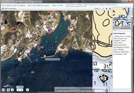
An interesting solution for the Jonesport uncharted breakwater problem came all the way from the S/V True Love in La Paz, Mexico. Skipper Bill Stockton has written a program called ChartAid which can turn Google Earth photo maps into BSB format so you can navigate on them in programs like CE, Nobeltec, and Chart View. I did get an “Invalid BSB” warning when I installed the chart Bill sent into CE, but it works fine. As you can see above, the registration with the official chart looks good, and my vessel, track, and route, plus data sets like GuideBook, overlay properly. Even the “properties” make sense, with the possible exception of the Source date. And apparently it’s easy to make such photo ‘charts’ with ChartAid…
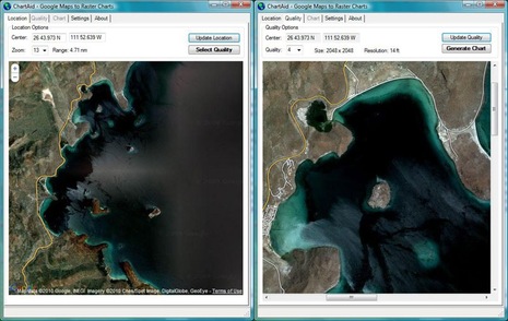
I haven’t tried ChartAid, but the instructions and screen shots (below) suggest that there’s little effort involved, and a fair bit of control over map boundaries, file size, and quality. It runs on Windows and a thirty day trial is free; after that the license is $99. I certainly wouldn’t want to do primary navigation on Google Earth photos in the semi-opaque waters I cruise, or anywhere really, but these ‘charts’ could be very useful on a second navigation window, especially where the water is clear and/or the available charts are really poor…like Mexico. And ChartAid reminded me that Fugawi has done some interesting work with Google Earth…
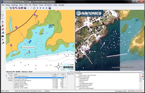
 So I fired up Navionics Planner2, which is a version of Fugawi ENC, and didn’t have any trouble installing the Google Earth plug-in. It’s pretty slick. Essentially you’re running GE full speed in a Fugawi window, and, if you want, it can syncronize with panning and zooming in the chart window. You can also turn chart windows into Google overlays with adjustable transparency, as shown in the screen shot. And according to the plug-in info I linked to you can also “Import
Google Earth maps to Fugawi Panel”, which sounds like ChartAid but apparently requires the full Fugawi ENC to work. There are lots of ways to be forewarned about an uncharted breakwater.


This is very cool! I have written to Bill Stockton (the author) to ask if his program can use formats other then GE, which would be very handy in lots of ways (other aerial photos, for example).
Michael
I’m pretty sure that storing data from Google and using it offline in another application is not permitted under Google’s license.
Is there a GPS datum issue with this imagery or does registering them on a particular structure or terrain feature eliminate that uncertainty? Scaling imagery to match charts and maps used to be a problem. CE takes care of this with their photo imagery. Do their algorithms do the same Google Earth?
Good point, Richard, and one I should have mentioned. Ron, if you click on the top screen, you’ll see that the Datum is listed as WGS84, which is what the ChartAid site claims. I think the registration is done automatically.
This is something that an iPad (or an iPhone or an Android device) can do right out of the box, no? (You do need cell coverage for this.)
Also, SeaClear includes a program that gives you the ability to calibrate and display most any graphic file as the “chart”.
Right, John; this is about getting the Google content into a form you can use in an offline marine navigation program. And while I think a number of nav programs can work with map images that aren’t already geo-positioned, the calibration is a bit tricky and/or tedious.
Easiest solution to this: Ask NOAA if you can have your rock back please,as they seem to have nicked it.
If not we’ll put it back ourseleves!!.
That *might* work??
Steve
Sorry to report that Bill Stockton is withdrawing his program until he can a “clear ruling” on the legality of using Google Earth this way. I was hoping that “for personal use only” with the Google copyright applied to the image was good enough, but apparently not.
In the USA, this orthoimagery is available free from the USGS seamless data warehouse. (http://seamless.usgs.gov/website/seamless/viewer.htm). It is not very user-friendly, but if you read the tutorial, you can download the NAIP data (1m/pixel color) for a selected area.
This is the exact same imagery as you get with Google or Bing maps. It is copyright free and can be used any way you like.
The data is delivered as a geotiff, which can be loaded directly into Memory-Map on a PC. It is already georeferenced, so no user calibration is required. From there it can be transferred to an iphone, ipad, etc for offline use.
I think that’s a real shame, why do the “big boys” always try to stifle innovative little guys??
Steve
I think this development has much to offer, I could imagine that someone, possible Google, may see the opportunity of providing portfolio’s of Google Earth charts for users of chartplotting software like Nobeltec that can offer a split view function of WGS84 sync C-Map cartography with Raster satelite photography when entering a narrow shallow unknown channel. I hope Bill gets the issues resolved soon.
I received an email a couple of days ago from Bill Stockton informing me, that the software is once again available and that updated information has been added to his web site
http://www.bellwoodgroup.com/marine/chartaid/
Happy Holidays!
Ronald
Thanks for the reminder about this, Ronald. Bill is taking the position that it’s up to users to decide if using his program is a violation of Google copyright. And I guess that makes sense since Google itself is pretty vague on the subject:
http://www.google.com/permissions/geoguidelines.html
Frankly I’ve struggled with those “fair use” definitions myself, in regard to using Google Earth imagery to illustrate a few of my MBHH articles like this one:
http://www.maineboats.com/coastal-adventures/gizmo-99
I think such use is OK, but am not sure. Expert opinion welcome (I think ;-).
I don’t think this is at all vague:
“Use in Software including GIS software, flight simulators etc: You may not scrape or otherwise export Content from Google Maps or Earth for use within another application.”
“Offline Use: You may not scrape or otherwise export Content from Google Maps or Earth or save it for offline use.”
(http://www.google.com/permissions/geoguidelines.html)
Bear in mind, the data does NOT belong to Google. They license imagery from many different sources. In the US, the imagery is paid for by the government and put in the public domain, but for most other places in the world, it is licensed by private companies. If all the data in Google were treated as public domain, companies like Digital Globe would soon go out of business.
Richard, I think there’s a good reason that Google put the Fair Use verbiage at the top of that page. Which is that when Fair Use is determined (not easy, as it’s a “balancing of four elements”) it can preclude specific restrictions. Valuable discussions here:
http://freegeographytools.com/2007/fair-use-and-google-earth-imagery
http://en.wikipedia.org/wiki/Fair_use
I was looking at it more from the developer’s point of view. I presume Bill has the standard Developer API agreement with Google, in which case the indemnity clause means he is fully liable for the use/abuse of his app.