
Earl aftermath, & thumb’s up to Bluefin Marine Weather

It is disconcerting when all the waterfront owners within a few hundred feet of your boat remove their floating docks for fear of hurricane damage! In fact, the harbors in my area were jumping on Thursday and Friday; lots of boats got hauled, and the rest of us hunkered down with chafing gear and extra lines applied, sails and biminis removed or trussed up, etc. etc. But Hurricane Earl lost its steam, big time. Even the Friday 6 pm forecast by our most reliable local source, Locus Weather, turned out to be way off the mark; instead of the predicted late night easterlies of 30-35 knots with gusts over 40, the GoMOOS F01 weather buoy recorded a max hourly average 14k with a max gust of 17. I slept aboard Gizmo like a baby…
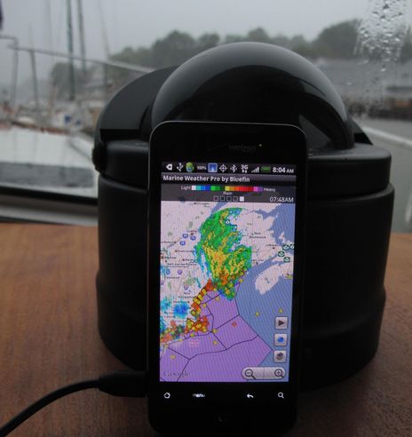
Like most people, I used multiple sources to track the storm, though most of the underlying forecasts and data come right from the NOAA’s National Hurricane Center in Miami. When I’m at a computer, my favorite is Weather Underground, which has some graphics like multiple computer tracking and intensity models that NOAA doesn’t seem to make available. But of course smart phones are getting very good at delivering weather data, and I’ve become particularly fond of an Android app called Marine Weather by Bluefin Engineering, seen below as Earl drenched us Saturday morning. It’s all just regurgitated NOAA data, but the app delivers animated NEXRAD radar, marine text forecasts, buoy reports, and tides all in one place, which is pretty much all I need most days. As you can see here, the screen gets pretty busy, but it gets better as you zoom in, and you can reduce the layers presented anyway. It’s been quite fast so far, though I haven’t yet taken it outside good 3G coverage. At any rate, my first clues that Earl was falling apart were the buoy reports south of Cape Cod that I finger tapped while having an early dinner at the Waterfront, and I later used it to keep tabs on real time conditions from my berth. A lot of this data is also now included in the new charting app EarthNC, and it would be nice to see it come to all Internet-connected charting apps, don’t you think?
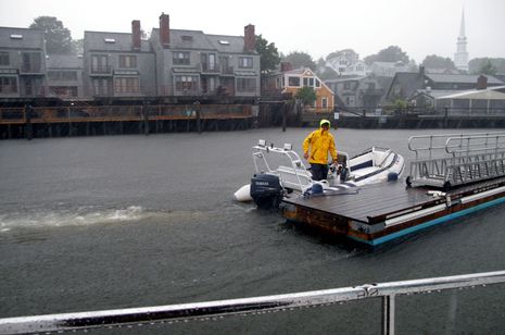
 Incidentally, I’ve yet to run into anyone around here who’s upset that the forecasts were wrong. “Better safe than sorry” is the phrase of the day, and everyone seems to understand that hurricanes are difficult to predict, as hard as all of NOAA’s meteorologists and super computers work at it. Note how this guy is grinning as he begins to reinstall floating docks in the last downpour yesterday morning.


Sailed into Bucks Harbor by 2 o’clock Thursday afternoon. Heard the earlier arrivals say they’d been advised to clear out of Camden. No moorings left in Bucks, so went around the corner to Horse Shoe Cove, where we spent the night anchored in the approach channel. Fri morning the crew from Seal Cove Marine was out stripping the canvas off the collection of Concordias and Hinckleys on their moorings. NOAA was still saying “Hurricane Conditions”. Talked to Bob Vaughn at his boatyard, who had no free moorings and advised a Bahamian Moor with two anchors “…oh yes the rodes’ll probably get twisted with the tides and the backing winds…” Not needing a night of anchor anxiety, put in a call to friends and backtracked up to the inner harbor at Blue Hill to hang on a lovely borrowed mooring. The rain washed the boat and the winds gusted to 10 kts. My kind of hurricane.
Tim Flanagan of Navagear sent along an interesting post about how hurricane intensity prediction hasn’t caught up with track prediction:
http://cliffmass.blogspot.com/2010/09/hurricanes-and-uncertainty.html
Just what happened with Earl on Friday.
LOve your posts Ben. This android app is great!
I’ve been using BuoyWeather ( http://www.buoyweather.com/ ) a lot this summer and have gotten unfailingly accurate and useful information there. The site’s predictions as Earl closed in on the Maine coast were on-target and told me we would see more than 10-15 knots in the SW Harbor area as the storm passed, just what we experienced.
The BuoyWeather name is a misnomer because it’s not based on buoys like those on the GoMOOS site. Rather, the site allows users to create “virtual buoys” which means it’s easy to download computer-generated meteorological information and forecasts for most any area of interest. It also offers an e-mail function–e-mails with forecast data sent daily to my address–something I’ve found useful for offshore passages where I have satellite e-mail but no Internet.
The bad news is that there’s a steep learning curve for new users and the cost for the service is about $80 a year. Nonetheless, I’ve found BuoyWeather a great resource and a good investment. One of the best uses I was able to make of came earlier this summer for our trip offshore from Fort Lauderdale to Norfolk; I used a BuoyWeather chart to show me the fastest projected Gulf Stream currents between my departure and arrival sea buoys, then created a route using waypoints in the fastest parts of the Stream. Doing that was easy and yielded our fastest run so far between Fort Lauderdale and Norfolk. A copy of the Gulf Stream chart I used for that is as: http://www.bluewaternav.com/aspx/blob2/blobpage.aspx/msgid/733743
Your mileage may vary! No connection with BuoyWeather other than as a satisfied customer.
–Milt Baker, Nordhavn 47 Bluewater, Southwest Harbor, ME
In this case, it was the track prediction that was wrong. Earl still did a lot of damage when it hit Halifax, and it killed a boater.
http://www.theglobeandmail.com/news/national/atlantic/tropical-storm-earl-changes-course-heads-toward-halifax/article1696345/
You’re quite right, Rick. I found an excellent NOAA graphic that let’s you page through every real time position and 3 day forecast track for Earl. It definitely took an unexpected right Friday night:
http://www.nhc.noaa.gov/archive/2010/graphics/al07/loop_3W.shtml
Incidentally, after a 2003 visit to NOAA’s Hurricane Center in Miami, I wrote an article introduction which attempted to use a few pop culture references to capture the dynamics of these storms:
“Hurricane season is upon us, and almost every saltwater sailor in North America must be mindful of these awesome phenomena. Only boaters north of Los Angeles are immune, while those on both coasts of Central America, in the Caribbean, and in the southeastern U.S. are particularly vulnerable. These storms, birthed in various obtuse fashions from the moist heat of tropical oceans, can generate nearly incomprehensible power—think cement blocks blowing around like gum wrappers. Yet, like jumpy Chuck Berry teens they “have no particular place to go,” and thus are steered-–-often drunkenly—by all sorts of other phenomena. A hurricane not only punches like Ali, but feints and spins like a butterfly. At some point this season many of us will feel the anxiety of a seeing a “named storm” head for the bit of coast our boat calls home, and a few will experience the total mental focus of sharing some ocean with one.
Thankfully, our government addresses the intensity of hurricanes with an equally intense vortex of technology and brain power…”
Hi Ben, As you know we made a fast exit from Camden on Dana Louise. We made a three day run to New Bedford to hide behind their hurricane barrier. It was not necessary but we made many new friends at Pope’s Island Marina. We will definitely return there. The whaling museum is exceptional. As for weather forecasting we go directly to the noaa sites first and find their graphical marine forecasts of wind speed/direction and wave height indispensible. You do need internet access and a verizon mifi card for us is the most reliable in the northeast. Regards, Brian
Milt, Thanks for reminding me of BouyWeather. I haven’t tried it in a while, but remember that I was really impressed with the founder back in 2001 when I wrote this:
“The future of GRIB is bright indeed. Besides meteorological offices eventually offering evaluated vector data, the models themselves will no doubt get better. Their output is already largely available to folks with the will and skill to process it. To see what a clever – perhaps obsessed – programmer can do with this stuff, you just have to visit www. bouyweather.com, which uses NOAA’s Wavewatch III model to generate very specific wind and wave predictions. Dan Martin, a former futures trading software programmer and windsurfer based on the north shore of Mauii, says he’s been on this project since 1994 “with intense focus”, and claims to have written the first Java program that reads GRIB data directly and dynamically. He also says that years of comparing model output to actual bouy conditions have convinced him of this model’s accuracy. His code will instantly reference a 30 meg GRIB file downloaded to his server twice daily and put up prediction graphs for any spot of your choosing or one of his preselected “virtual buoys”. He is planning to introduce a subscription service that will deliver similar results in text form as e-mail, or even to a WAP enabled cell phone – for a projected 10 cents per message. No doubt we’ll see all sorts of interesting GRIB style products in years to come.”
http://www.grib.us/
I have used Ugrib for over a year now and I have been very happy with their accuracy. During this year we have sailed from Norway and passing Faroe Islands, Iceland, Eastcoast Greenland, Labrador, Newfoundland, Nova Scotia, Newport RI, Bermuda, northern Westindies and back to New England.
I stayed on a mooring in Sherman Cove off Camden, during the “Earl” timeperiod. All though I secured the boat for a hurricane, I felt farley certain that it would not blow very hard. Ugrib showed 15-25 knots of wind reaching the Camden area the night to saturday and that was pretty much what we got. I had a couple of high gust peaks at 30 out here, but nothing sustained at that windspeed. I had altso followed the low that ended up being “Earl”, since his birth near Cabo Verde off Africa’s westcoast.
The best thing with UGRIB is that it is FREE! No charge….
Thanks, Trond (and thanks for helping with lines after the boat parade yesterday). And I know a crack meteorologist who may be slightly relieved to hear about those 30 knot gusts you saw. That would be Ken McKinley of Locus Weather, who was somewhat taken aback by my characterization of his Friday night forecast as “way off the mark.” He has a good argument.
Ken did not predict easterly wind but rather northeast backing toward north, which is a significant difference for Camden and several other Penobscot Bay harbors. And while he was off on wind velocity, he was nearly spot on about rain fall volume and timing. Moreover, and probably more important, he had a pretty good handle on what would transpire several days prior to Earl’s arrival. In fact, a chance run-in with him on Wed. helped me decide to stay on my float instead of anchoring somewhere with more protection (which would have been a major pain).
To be perfectly clear, my mention of Ken’s mistaken wind forecast was meant to illustrate the peculiar — think Chuck Berry duck walking — nature of hurricanes, not his forecast abilities. I know all sorts of boaters and organizations that count on Locus Weather for refined local forecasting, and also for world-wide vessel routing. Ken has been doing this a long time, he’s good at it, and he’s one of the very forecasters willing to differ a bit from NOAA’s big picture hurricane predictions: http://www.locusweather.com/
That said, here’s Ken’s interesting analysis of what actually happened Friday night:
“You mentioned that your first clues that Earl was “falling apart” were the buoy reports south of Cape Cod. Actually my first clues that the system was not as strong on its west side were earlier when no hurricane force winds were reported at Cape Hatteras when the system passed by there Thursday night and early Friday. This gave me confidence to lower my wind speed forecast on Friday from where it had been a couple of days earlier, but also made me feel stronger that we would see the wind speeds along the Maine coast that I forecast on Friday.
This is because as a tropical cyclone undergoes transition to an extratropical system typically the wind field will enlarge even as its absolute strength is diminishing. This is why I did not forecast consistent tropical storm force winds, but did maintain the 30-35 knot forecast. However, looking at the data through Friday night and Saturday, it is apparent that Earl maintained its tropical structure longer than anticipated through Friday night and Saturday morning, and even though it was downgraded to a tropical storm late Friday evening, some of the data suggests that it may actually have regained hurricane strength later that night or early Saturday prior to its landfall in Nova Scotia, although this was not indicated in the official advisories.
Certainly hurricane conditions were experienced in Nova Scotia, leading to power outages for more than 20 percent of the entire province, significant damage to trees and infrastructure, and at least one fatality. The maintenance of the tropical circulation for longer than was anticipated (thus delaying the expansion of the wind field), in combination with the track being a bit farther east than forecast (not that much, but just enough) meant that the winds experienced here in Maine were much lower than the predictions.
I will learn from this event, as I hope I do from all weather events, and hopefully it will lead to more accurate predictions from me in the future. However, I don’t regret my advice to my clients regarding this system, which basically was that most boats in Penobscot Bay did not need to be hauled; that most Penobscot Bay harbors would be sheltered from the strongest winds and thus generally safe; that extra lines, extra fenders, extra chafing gear were prudent measures to take; that all loose items should be secured; and that it would be prudent to remove very small boats and dinghies from the water when it was easy to do so.”
I used passage weather to track Earl. It never showed that our area would receive more than twenty knots of wind. They were right on. Good or lucky I dont know but in the past they have been accurate.
http://www.passageweather.com/
I’ve come to rely on TropicalStormRisk.com as my first-line of information. It’s a UK site that’s funded in part by the UK marine insurance industry,
so arguably they have more than a passing interest in being on top of what’s happening. Their alert messages and forecast methodology are clear and directly actionable with a number of different “lead times” shown. Having been on the last flight out of an impending hurricane strike a couple of times now, TSR has given me the insight to buy those tickets while they were still seats available. (grin)
The analytical discussion on WUnderground.com is usually good reading, but for the people who just cannot get enough bits under the fingernails, the US Navy Fleet Weather Service can fill your bit bucket to overflowing many, many times over. And obviously, they take a keen interest in staying on top of the WX situation everywhere on the globe.
The fact that more and more of these rich services are now viable on very portable platforms is a huge change from the days of illegible WEFAX over cranky HF radio.
http://tropicalstormrisk.com/