
iNavX on the iPad, a Beta tester’s enthusiasm
Navigation on iPad is a hot subject, as discussed here recently (and, mind you, Navionics has now joined the fray). So I’m pleased to publish the following excerpt from a review by Tom MacNeil, a long time beta tester for the GPSNavX/ MacENC/iNavX family of charting programs. To say that he’s enthusiastic about how developer Rich Ray’s software runs on an iPad is an understatement! Tom has been sailing and messing with boat technology for thirty years, and currently runs an marine electronics and electrical shop somewhere in the Pacific Northwest. Warning: If you read the following, you may soon find yourself at the Apple Store typing in your credit card number…
I haven’t been this excited since since I was a kid waiting for
Christmas. The big present was the new 64GB iPad 3G. When Apple made the
first announcement, I knew that this could be a solution to
navigation on boats. Not only did I know this, but developer of iNavX
marine software for the iPhone, Rich Ray also knew this to be a fact. I
have been a Beta tester for him since the early days of GPSNavX, MacENC
and iNavX. I knew that iNavX would scale perfectly to the iPad, and
that was Rich’s full intention.
As the six weeks of waiting
spiraled down, Rich was very busy working on the new application. Unlike
some other developers, he decided to keep this application a “universal
app”, which means it will run on the iPad, iPod Touch or the iPhone.
The consumer only has to pay once.
Finally delivery day for
the new iPad was upon us. I personally met the FedEx lady and received
the package. Rich wasn’t far behind and a couple of days later I had
the first beta for the iPad. Rich had taken full advantage of the
added space that the iPad offers with a “Compass Banner”/ “Instrument
Banner” on the top and a “Tab” menu bar on the bottom. The various
charts display superbly on the bright sharp screen.
 First
First
things
The first thing I did was download all the charts I would
need. This was done through X-Traverse, an online supplier iNavX uses to
move docs and charts back and forth. I was able to download Navionics
and Canadian raster charts. (This app was designed to display many
different chart formats). I had previously downloaded the charts I would
need from NOAA.
Adding new routes took a bit of learning, but
not too bad once you get the hang of it. It is a simple matter of
either showing all the waypoints you already have in iNavX
(“settings” > toggle on/off on top of screen), and tapping on them to
make up a new route, or creating new waypoints by tapping on the chart
and selecting the “waypoint” button. A pop-up window appears asking you
if you want to add to the route. Simply tap out your course.
 At
At
first blush the charts looked stunning on the iPad. You are struck with
the clarity of viewing on the iPad’s 1024 x 748 pixel display. Apple
has done a superb job on this screen making it viewable from the most
oblique angles. The method of multitouch, making finger gestures on
screen to get the desired information, made it a great experience. The
iPad also has the advantage of portrait or landscape view. Up here in
the Northwest, we do a lot of north and south cruising, making portrait
view very useful.
Laying in a course
Now it is just a
matter of tapping on routes and picking the one you want to navigate.
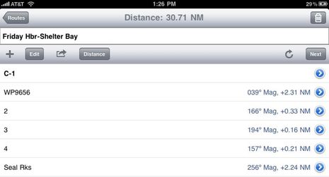
In
this case we are going from Shelter Bay to Friday Harbor. Nuts, Wrong
way! Okay, no problem. I simply touch on the route title which opens up
Friday Harbor to Shelter Bay, showing me all my waypoints (on each
w/p, the degrees magnetic and distance). I hit the little roundabout
arrow above, which reverses the route and I am ready to go. At page
top, I hit the “go to” button and then in the upper left touch
“Routes”. I touch “chart” in the Tab Bar and there I am. I have
activated the my first route.
 Getting under way
I
felt the iPad would not be just an “in between” computer on your boat,
as some have suggested. A correctly written program could be completely
self-contained, fitting all your needs.
With that in mind, here
is a typical trip…First thing, get the iPad ready to go. Launch
iNavX then… to the setup page (which is the first page that you will
find in this program) and pick your desired chart. In this case, because
of it’s simplicity, I pick the Navionics charts which covers the entire
US, and are priced appropriately. The Pacific Northwest is my cruising
grounds, so I pick Puget Sound. The chart loads up right away. I tap on
“chart” and that forces the program to center on my vessel. One thing
that I have learned, the GPS inside this iPad is not like the GPS in the
iPhone. Although I have found that to be adequate, this is a superior
unit. Even sitting inside my house, this GPS acquires a signal. It is
much more sensitive, and I found the accuracy to be quite good.
We
cast off the lines, and since this is a beta test, I am looking for any
anomalies or problems. As I come up on my first waypoint, I have
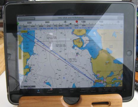
the iPad propped up in a vertical position. As a side note, I made a
small wooden tray, which consists of cutting a slot in a pice of wood, a
half inch wide and 7/8″ deep that the iPad sits in … either vertical
or horizontally, with a wooden base and soft rubber feet on the bottom,
so it stays stable in my cockpit.
Getting from point A
to B
I double click on the first waypoint I am approaching. Up comes
a pop-over which gives me several options. The first one is “next Bouy
6” which advances to the next waypoint. As previously mentioned, if I
were working with routes, it would allow me to add/edit this waypoint,
zoom in, zoom out or activate tides andcurrents in my area. This current
version of iNavX does not have auto next (as yet), so when I come upon a waypoint,
it is a simple matter of double tapping and hitting “next” to advance
the w/p.
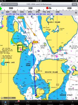
Since I have activated the instrument strip at the top,
which is user selectable, I am now reading the COG (Corse over Ground),
SOG (speed), XTE (my cross track error), BTW (bearing to w/p), DTW
(distance to w/p) etc. I have the option to put in HPD so I can see just
how valid my satellite signal is.
For this section of the
trip, I have elected to use the iPad’s built-in GPS. The compass banner
is taking direction from the GPS. (When HDG is set to “off” the compass
reverts to GPS.)
Reflections
It will be an
interesting test today because usually in the Northwest, you don’t have
to worry about sun, as it’s normally cloudy, making screen viewing
easier. However today is the exception with sunlight streaming in. I
gave up a long time ago trying to see a laptop screen, or any other type
of display in the cockpit. I finally broke down and bought a sunlight
viewable display, which has worked beautifully on the boat.
Would
the iPad work outside? Well here it sits right in front of me. Sunlight
is hitting both the outdoor screen and the iPad. So far no problem
viewing. It is a remarkable screen, the only problem is reflection, I
might have to turn it a bit to keep a direct reflection off, but all in
all very easy to read. If you take it out where the sun is hitting it
directly, it’s a challenge.
Right away I notice that my track
is being laid down behind my course, and just for the heck of it, I
switch over to the tracks page, where I can see that iNavX is keeping
accurate account of my trip. My tracks can be imported and exported. I
have stats, such as count, distance averaged, and elapsed time. If I tap
on a track in the lower Tab Bar, up comes a popover that gives me that
particular track, the date, Lat/Lon, speed over ground, and heading.
For the rest of Tom’s review — including info on iNavX AIS, weather, and tide displays, as well as its ability to connect to boat sensors via WiFi, and lots more images — see this page. You’ll find at the end that Tom “would have no trepidation about cruising
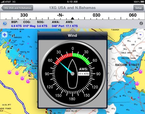
anywhere” with this set-up, but I think we’ll be debating that notion for a long time. Meanwhile, the pads, tablets, slates, etc. will get better and better, as will the apps. iNavX, for instance, just got “analog” instruments:


I’m facing a complete electronics refit on a 46′ sailboat destined for coastal New England/LIS cruising and occassional long distance races. With so many advances in technology recently, including this marvelously elegant solution, the choices – and price ranges – are bedazzling! Given the steep electronics budgets of many owners, knowing full well how quickly they will be obsolete, makes one wonder just how little someone could realistically spend to achieve 85% of that result and still have a truly capable coastal solution
If you are seriously considering a 3G iPad you only have until June 6 to order one and still get “Grandfathered In” to the unlimited data plan and you have to sign up for auto renew and stay on it permanently to avoid losing it. After that it will be $25/month for 2GB with overage fees above that, which could be very limiting if you plan to use it as your main internet source onboard.
http://www.engadget.com/2010/06/04/atandt-extends-olive-branch-will-let-ipad-all-orders-before-june/
Beware though, that since this is specifically a no contract deal, they can change the terms and data limits anytime and as often they want. Possibly as soon as they think they can get away with it.
ATT says that 98% of their data users use less than 2GB but that is based on smartphone users which use tiny screens that are directed to mobile sites. The whole point of the iPad is it’s ability to surf full websites, download streaming videos and music, Netflix movies etc. You (or your teenager) could blow past 2GB with just 2 movie downloads and a few Youtube videos if no Wifi is available where your boat happens to be.
If you just want to use it as a plotter, check your email and do some light web surfing you’ll be fine. Don’t buy the 3G thinking you can do more than that.
I’m using iNavX myself. I believe it needs to interface with an external bluetooth or WIFI GPS receiver. The internal AGPS can be very unreliable – to the point where I almost hit rocks – and does not work outside the cellphone coverage area.
I’m guessing you’re using iNavX on an iPhone, and I agree (as do many) that its GPS is pretty poor. But it will work beyond cellular coverage, or at least the 3GS model will; I tried it 50 miles off Galveston. Apparently, the iPad GPS (only in the 3G model) is quite good.
The other anonymous makes good points about the change it AT&T data rates. It’s bad news, and may mark the end of the Verizon $30 a month unlimited data service I’m currently enjoying:
https://panbo.com/archives/2010/05/verizon_droid_incredible_indeed_it_is.html
And remember this is a pilot house only type setup. The iPad (I own two) has two humidity sensors inside and if either registers too much humidity, the warranty is null and void.
In an average week of surfing only, no downloads or streaming anything, I use about 500 MB worth of data so the unlimited plan is the only way I would use 3G. I’m grandfathered in….
I’ll keep mine in the house…
One thing these great little programs are missing and I’ve mentioned it before and will again is what to me is the MOST useful feature (my IQue has it) which is the course heading line which I set to infinity.
I use the handheld plotter for positional info in the cockpit to compare a plotted fix on a chart with my observations. When I am head into port or trying to make a buoy or a mark I don’t use a waypoint typically at close range, but turn the boat as observe the course line to see if it is crossing the mark or buoy I am going for. This can even be something I can’t see with my eyes and this heading line will show me whether I am going to pass over thin water or ledges or other hazard.
This is more critical than entering a waypoint and getting a compass course which will not show me the above. Of course when the plotter draws a rubber band line from the entry location to the waypoint this is kinda similar, but the heading/course line is continually updated and a rubber band from the entry point is simply an imaginary line which was valid for one instant or if you manage to remain on that line… which is rather unusual.
I don’t know what this programmers leave this vital tool out as it’s a life saver and the best use of these little devices in the cockpit.
I believe the “course heading line” is the same as the “velocity vector” in iNavX. The velocity vector is a line drawn from the vessel position out X minutes (user selectable) based on speed over ground at the angle of course over ground.
Yellow line is velocity vector..
http://inavx.com/images/compare/iNavXVelocityVector.png
GPSNavX,
That would be it, but I don’t see the feature in NaviMatics or Navionics for Iphone.
I can’t see how some programmers (navigators) missed this.
Jef
A comment on humidity sensors…
I have owned three iPhones. I work around water constantly in Marine electronics. I live in a very rainy place. My cruising takes me up into the wiles of Canada on the west coast, where I have my iphone with me when I adventure out in the dingy. I have never seen the sensors turn in any of my iPhones. (yes, I had to take my 3Gs into Apple for an unrelated repair. The Genius checked the dots out very carefully)
It’s too early to say the same about the iPad, but i’m guessing it’s about the same.
Perhaps conditions are different in Florida, but around here it’s never been a problem.
About the price. I was pleasantly surprised to see that if you already bought it for the iphone/touch, you don’t need to buy it again for the ipad. You can use it on both at the same time.
However, the charts are different, so if you use Navionics chart, you need to buy them twice.
While most use the free official most up to date NOAA RNCs with iNavX, it is true that Navionics requires the charts be purchased for each device (unlike the other charts available from X-Traverse). Navionics even have their own iPad specific apps instead of just one app for all devices like iNavX. The good news is the Navionics charts are very low cost. The super regions 1G and 3G are a great deal at $20 or $50 depending on device.
I am not sure how well these work, but I just ordered an antiglare film for my Viliv (an UMPC).
I got it at http://www.nushield.com
I will drop you a line and let you know how it works out.
great review and comments thanks.
Could someone please post more pictures of the analog instruments? Are there other wind gauges?
Also can someone explain the benefits of buying iNavx (AUD$50) rather than buying Navionics (australia) (AUD$15?).
Thanks
Instrument screen shots..
http://www.inavx.com/images/screenshots/iPad/screenchartcompass.png
http://www.inavx.com/images/screenshots/iPad/screenchartspeed.png
http://www.inavx.com/images/screenshots/iPad/screenchartwind.png
Wow that is impressive. If you were able to have multiple instruments on the screen this could replace a lot of kit.
Its a real shame the data input has to be wireless. The device has a usb host on it, but it seems access to it is very restricted.
The new iPhone 4 has the same GPS receiver iPad 3G has. This is a significant improvement over the lack luster performance of iPhone 3G GPS receiver. Pre-sales of iPhone 4 are through the roof.
RAM Mount coming out June 6 – http://www.ram-mount.com/NewProducts/AppleiPadMounts/tabid/2614/Default.aspx
Tom MacNeil has put together an excellent video showing waypoint and route creation in iNavX ..
http://web.me.com/tamacn3/TME/Movie.html
I have installed four different Navigation programs on my iPad for test. iNavX is my favorite.
The only thing i am missing is the GPS satellite chart.
Before I bought the iNavX I used Free Technics system but everything with the iNavX and iPad is stunning and to a fraction of the costs.
I am waiting for the engine and electrical monitoring system from Aviasail and have tested the current program with navigation instruments. Not so good as Free Technics but the cost make the differences.
Beside the iPad (as a slave) I have built a Navigation Computer based on the Intel Atom Processor N270 as recommended by Avia Sail.
I did it before I saw Avia Sails recomendation. Now I will try to fit a PCI radar board from IRIS system in to this small book-computer.
I can tell you one thing so far – this is a Paradigm shift i Navigation and ship control when it comes to price performance.
And together with the ship system you have a fantastic entertainment system in your iPad using your wireless network to stream music video and show pictures.
I have more but I will tell you about it later. I am using the system with ROV, Magnetometer, underwater cameras and Side-scanners since my boat originally was refitted for diving explorations.
I will install all the necessary instruments and senders from Maretron and report my findings.
My boat is a 50 feet Riva Super America refitted in Malaysia and Thailand. The boat is refitted like new and have two 440 Hp Yanmar engines. I will test the boat in the Melacca Strait from Singapore to Phuket and in the Andaman Sea.
I love iNavX and want to get an iPad for the boat as a portable nav screen (hopefully to eventually find a waterproof option for the cockpit, but initially for evening viewing when NAV computer is shut down. My missing piece of kit is a cheaper option to put the NMEA (RS232) onto our network so the iPad can use the boat instruments all the time (even when nav computer is shut down to save power and wear and tear). What I have found so far is over $300 which seems ridiculous for this simple task and adds 65% to the iPad cost. Any solutions you guys have seen
Hi Sten,
I have a Riva too-a Corsaro 60. Great boat.
Why did you like the iNavX over the Navionics app for the iPad? I’m interested in a comparison between the two.
Thanks,
Peter
iNavX 3.2.0 is now available from the iTunes app store. It’s a free update for all iNavX users as we don’t believe in re-charging customers who already paid for iNavX. iNavX 3.2.0 adds chart emailing and printing, and Brookhouse iMux support in the form of sending the active waypoint NMEA data to the iMux output port (i.e. to an AP). iNavX 3.2.1 is already in the works.
For those of you who have not experienced the bad news yet, GPS NavX will crash if you upgrade to the most recent version (Yosemite) of the Mac OS X.
I am told by the company that the only way to solve the problem is to spend (another) $59.95 to buy the latest version of GPS NavX or go back to the older OS X.
Not very nice. I liked GPS NavX, though not enough to spend another $60 bucks. I have PolarView NS v 2.03 and it works fine under Yosemite and so far all updates have been free.