
The damn iPad: iNavX, X-Traverse, Navimatics & AC
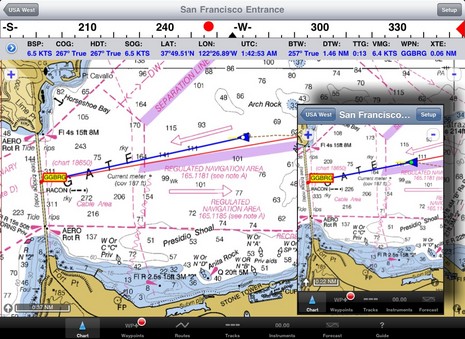
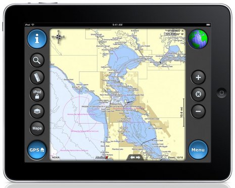
It’s so sad: Nowadays when I contemplate my amazing portfolio of iPhone marine apps (discussed here, here, here, and elsewhere) in iTunes, featured right across the top of my PC screen are the ones now also optimized for the iPad. But I don’t have an iPad (though I did touch one). And behold the difference. The size of what you see when you click on the image above will depend on your particular screen’s pixels per inch, but the proportions are right regardless. iNavX on a 9.7-inch, 1024 x 748 pixel iPad is obviously quite different from iNavX on a 3.5-inch, 320 x 480 pixel iPhone. There’s room for more chart and bigger touch buttons, not to mention nav data and a compass ribbon across the top. Damn…
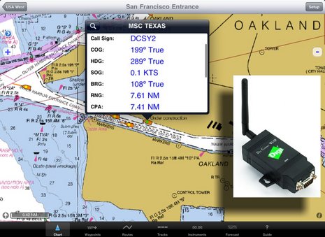
In fact, the iNavX web site now boasts “The power of a color chartplotter for a fraction of the cost” and, while I’ll stay out of that argument for the time being, developer Rich Ray does make a good case for how far he’s taken the software, and how able it looks on the bigger iPad. Note, for instance, the series of screen shots comparing iNavX iPhone and iPad versions. Ray has also gotten his program to play nicely with a Digi Connect WI-SP WiFi serial server, which means you can get AIS and other NMEA 0183 data flowing to your iThing without any other computer involved (and he even added a Digi Connect guide to his extensive help files).
 And if you want to use your spiffy iNavX/iPad combo with anything but free NOAA raster charts, you’ll be pleased to know that X-Traverse keeps growing its already giant cartography portfolio, and adding to what the service can do (new Facebook integration, for instance, plus integration with Navionics NavPlanner 2). When you purchase charts via X-Traverse you get two activations, so if you’re already using them on, say, an iPhone but haven’t activated them with a PC or Mac, you’re probably good to go if you get an iPad. The exception: Navionics is pricing its iPad charts differently — understandable, I think, given how inexpensive their iPhone charts are, and their many partnerships with companies that manufacture those old time chartplotter things — though $50 for the new U.S. super region is not bad. That region includes the Northern Bahamas, by the way, but below is a sample of alternate NV charts of the same area, also offered by X-Traverse. Choices are good. And I’m not done…
 Navimatics has not only adapted its Charts & Tides program for the iPad, but expanded the included regions of NOAA ENC charts, lowered the price, and is just about to add support for ActiveCaptain! The implementation looks good on an iPad, too, as you can see below. As with MaxSea TimeZero 1.9 (just about to release!) and the Coastal Explorer 2010 beta, the ActiveCaptain data is cached so you still have it when not connected to the Internet. And we know Active Captain itself is also working on an iPad app. Damn.
So here I sit without an iPad (despite my efforts to bum one from some Yachting reader), and look at all the boating apps below that will no doubt grow to iPad size eventually. (Some of which I haven’t even reviewed here yet, sorry.) But I kid; what I did acquire recently is a smart phone that makes the iPhone seem positively pokey. More on that soon.
PS (thanks to Brian’s comment below): On May 12, MotionX HD with NOAA ENC charts (like Navimatics) was introduced on May 12 exclusively for the iPad, for $3…damn:


Okay, I’m reading this post on my iPad and am ready to buy one of these lovely apps…but which one? Need you to bottom-line it for us, Ben.
For what it’s worth I was never that impressed with Navionics vector on my iPhone but at $5 I couldn’t *not* buy it.
I posted some screen shots of the Santa Cruz, Monterey Bay, West Coast California of the various iPad marine charting apps..
http://www.macsailing.net/fbb/showtopic.php?tid/1066/
Each iPad marine navigation app has exciting features.
One feature which is most handy for using a hand held device with charts is a heading line and a course line which enables one to steer to a charted object… like a buoy.
I find this much more useful than inserting a waypoint and using things like cross track error or some course correction in degrees.
Look at the plotter… turn the helm or autopilot and watch for the course line to align with your intended mark. It’s really that simple…
I’ve got Namatics (just purchased) but I don’t see this feature and if it’s not there it’s a fatal flaw.
I have charts loaded on my ipod touch,and I always thought,gee wouldnt a bigger touch screen be nice!
Sigh…I guess I know what I’m going to be buying!
Of course then I will have to get a hotspot so my macbook,ipod and ipad can share internet access.
The apple touch interface is so intuitive and the tablet form is great for planning and viewing, I think charts on the ipad will be a big thing.(plus a waterproof skin!)
Let’s remember, I’m a Mac devot�e, but the iPad doesn’t have a sunlight-readable screen (yet, hope hope). The day it does, I’ll snap one up.
Here is a screenshot comparison from North Lake Washington near Seattle.
Google maps:
http://maps.google.com/?ie=UTF8&ll=47.671977,-122.241783&spn=0.077216,0.110378&z=13
Navimatics (zooming in will bring additional detail and depths):
http://navimatics.s3.amazonaws.com/LakeWashington-Navimatics.png
iNavX:
http://navimatics.s3.amazonaws.com/LakeWashington-iNavX.png
That’s not really a fair comparison. Perhaps a shot of iNavX running Navionics vectors would be more appropriate?
For comparison, North Lake Washington.
iNavX using Navionics charts from X-Traverse:
http://www.inavx.com/images/compare/LakeWashington-iNavX.png
Hi,
Love the piece about iPad. But my question is how does iPad get it’s GPS signal? It has no ports.If you are in spotty cell territory, how true is the position? Please help!
Cheers,
S/V enCharrette
Ben,
You are opening yourself up to a whole world of questions! Which apps are best? Or even exist?
There’s a better phone for apps than the iPhone?
I can believe it (not being an Apple fan) but does it have the range of navigation/sailing apps? You are in touch with the industry. Are they making/porting apps to android? What?
Perhaps you can add a page of what apps exist and their platforms.
Thx,
dge
Meh. You can keep any apple product. Sorry, had a bad experience with support.
The issue wasn’t important. What was important is that they gave me no choice but to schedule an appointment, drive an hour to an apple store, and then wait an hour just to find out they couldn’t fix it.
All I wanted to do was drop the danged thing off. Better yet, give me a mailer and I’d send it in.
Why do I have to sit there while some high skul dropout runs through scripted diagnostics?
Sorry. My time is more valuable then to use it to be treated like an idiot. I get paid a lot of money to be treated like an idiot and I’m not just going to give it away.
I don’t care how good it is.
Now give me a sunlight readable linux pad with a good hypervisor to run virtual machines, and I’ll be there in a flash. And yes, I know apple hates flash which is why I like it. 😉
I’ve had my iPad at my helm since it was released on April 30th. I’ve put about 600 nm on it – offshore, overnight, ICW, close quarter handling, and now the Chesapeake Bay. I have all of the various products for both iPhone and iPad including some pre-release software. The main thing that I learned from this use is that none of these products, and I mean none of them, are chartplotter replacements. None will be your primary navigation product. It just isn’t going to happen without a lot of maturation and a lot more software development. Instead, most of the products have a use that makes them more of a companion to your existing chartplotter. For this reason, there is no one “best” product to get. And the price of them really allows you to have a few of them and take advantage of their capabilities where needed.
For example, I believe that Navionics (for iPhone – it isn’t out on iPad yet) is the best tide and current software available. They did a stellar job with it. I use it every day. Personally, there are things about the chart display that I don’t like and I hate the way they rotate their charts – the text ends up upside down as you rotate causing confusing soundings at times. But no matter what, for tides and current prediction, this is your app.
Next, the coming ActiveCaptain app. This is an unfounded rumor. We have no app. We have a variety of concepts that we’ve developed about what a chartplotter companion should be. We’ve decided to focus our energies on developing the best POI data possible along with some interesting extensions that are coming next. In doing this, we decided to work with the best developers and highest rated software products so that ActiveCaptain can be easily integrated into their products. Coastal Explorer, MaxSea Time Zero, and Nobeltec are examples. More are coming. I pitched the idea to Bill Zissimopoulos because I thought he had the things most critical to companion success – seamless, quilted chart display, proper chart rotation for course up display, and speed. Bill agreed and created a fantastic implementation. It is out-of-this-world incredible as a guidebook replacement. You just have to see it – iPad or iPhone.
One other point. It’s easy to cherry pick a screen shot for display. Using these software products in real life is much more than that. There are user-interface issues, features and capabilities, and the ability to fit with your own helm environment that matter much more. It’s not about pretty pictures. It’s about finding that place where the iPhone or iPad enhances your boating experience making it easier, safer, and more fun.
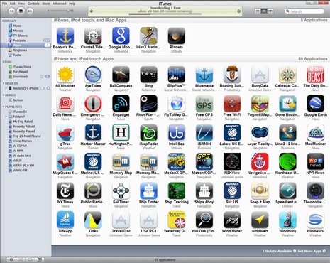
Oh… I do love my new iPad. It does easily replace my netbook for my primary need which is business email. I even got my wife excited ( … 🙂 … ) One thing about iPhone et al is … APP overload. The picture above, with all those App icons is a case in point. Not to say, that my iPhone and now, iPad, do look much different, BUT. I think all of us iPhone/iPad addicts get carried away with downloading (and paying?) for Apps.
With no cellular signal I’ve had enormous problems getting a GPS fix with my iPhone (3Gs). When I used it in Bonaire, it placed me in Messina, Italy! In China, it was just lost. Does anybody else have this problem?
Isn’t anyone concerned that these are consumer products not made for salt water? I guarantee that Apple will not honor a warranty when you bring in an iPad or iPhone that has received a dose of salt water.
If the Garmin 3750 is any indication, we may soon seen devices designed for marine use that have a lot of characteristics in common with the iPad.
Sorry for the confusion, Jeff. I misunderstood and thought you were developing an ActiveCaptain app yourself; but once explained your strategy makes perfect sense.
Did you mean to say that Nobeltec is also adopting AC POI data? That would good news!
Yes, Nobeltec v11 will be integrated with ActiveCaptain. I was told it will be released this Fall. I have the previous version installed and am helping to test and support it as test versions are released.
I had mentioned creating Layar support for ActiveCaptain but realized that third-party support in other products is much more important. Giving those navigation programs the capability of keeping the POI data offline and synchronized to our server is powerful. Using it in real life on my own boat has made me wonder how I ever got along without it.
Ben, come to Castine this Summer and let me show you what’s coming next! The ability to use POI’s integrated with navigation presents interesting things that haven’t been possible before. Some were shown in my iPad mock up but I’m saving the best for later when it’s released…
The question is: is iPad 3G (the iPad with enhanced GPS) just a Toy or a Real Tool? When I took my preordered 64gig 3G iPad out of the FEDEX box 30 April and tested its position finding capability on Google Earth… it tracked me walking from the living room to the kitchen…and really FAST! As long as you’re in the range of 3G / cell towers (US shallow waters) this TOOL will out-performed all my other navigation devices including my Garmin 5212 touch screen MFD. It’s Fast (computing speed to a new level) and makes everything else so slow by comparison. When touch tone phones replaced rotary phones did anybody want to keep the old phone? So Go On and get the best 3G iPad they offer (64 gig 3G iPad)…Captain you need this TOOL to prevent your next grounding ( or anchor dragging)…it’s not a Toy.
This is an abstract from a GIS paper
“The 3G iPhone was the first consumer device to provide a seamless integration of three positioning technologies: Assisted GPS (A-GPS), WiFi positioning and cellular network positioning. This study presents an evaluation of the accuracy of locations obtained using these three positioning modes on the 3G iPhone. A-GPS locations were validated using surveyed benchmarks and compared to a traditional low-cost GPS receiver running simultaneously. WiFi and cellular positions for indoor locations were validated using high resolution orthophotography. Results indicate that A-GPS locations obtained using the 3G iPhone are much less accurate than those from regular autonomous GPS units (average median error of 8 m for ten 20-minute field tests) but appear sufficient for most Location Based Services (LBS). WiFi locations using the 3G iPhone are much less accurate (median error of 74 m for 58 observations) and fail to meet the published accuracy specifications. Positional errors in WiFi also reveal erratic spatial patterns resulting from the design of the calibration effort underlying the WiFi positioning system. Cellular positioning using the 3G iPhone is the least accurate positioning method (median error of 600 m for 64 observations), consistent with previous studies
”
Do throw away your marine GPS just yet
DAve
I do not see these little devices replacing a fixed mount plotter. I like to use the hand held to confirm what my eyes see… or look for something that the heading / course line tells me I should see on the bow.
I can see how one could find your boat anchored in fog if you went off on the dink and the fog pulled in… but the interface with the Iphone is too small. The iPad may improve that a lot, but then it might require two hands and you need one to hold on to the boat!
I was hooked on these little plotters when I got the Garmin iQue ages ago. Once I had a view of the boat on a chart my trips to the chart table where the fixed mount GPS is went way down. With a waypoint entered into the fixed mount with data repeaters in the cockpit… all I need is the little pic with a heading line and I know where I’m headed.
They’ll get better over time. But I’ll be too old to be able to use all the features by then.
Posted on Apr 30, 2010 3:55 pm by Dan Moren, Macworld.com
“The other feature the 3G-enabled iPad adds is an actual GPS chip�unlike the Wi-Fi iPad, which relies solely on Wi-Fi-based location. A quick test in the Maps app between the Wi-Fi iPad and the 3G iPad showed no difference in speed in locating my current position, though the 3G iPad did enable a more precise location.”
So Captain, again I say, Get a 64 GB 3G iPad….not an iPhone…the Speed of the processor and the Precision of the GPS fixes may have the Military curious.
Can you tell, I am WOWWED.
Darn. The link dropped out of my last Post for Dan Moren’s article which is:
http://www.macworld.com/article/150966/2010/04/firstlook_ipad_3g.html
WOWWED!!!
And just in case you thought these choices were going to become easier – enter – stage left – Motionx GPS HD for the iPad. It includes the NOAA ECN charts. For 3 bucks it is terrific. Spend some time with this and you will be very
impressed. These guys are great programmers and very tuned in to user needs. One of the features is the permanent download of exactly the charts you want by area or route.
Brian
Thanks, Brian, sort of! I’ve always liked MotionX GPS, and, in fact, the racing sailor (and uber geek) Phillipe Kahn is behind it:
https://panbo.com/archives/2009/03/iphone_nav_forward_in_many_directions.html
The charts in MotionX HD look good (I added the screen shot above), even if only termed “experimental” so far. And are only available for the iPad, at a ridiculously low price. Damn!
http://news.motionx.com/category/motionx-gps/
I have been using two iPads, a WiFi and 3G, along with a charting program on a MacBook Air, and Navnet 3D. With brief use, I can relate that the iPad is easier to use, can be carried around the bridge (and boat), and wins hands down as a GPS unit. The Navnet is cumbersome to have to use the Roto and the scrolling pad…in a mild rolling sea it’s hard to nail the pointer on objects. The iPad is a clear winner in this regard. The MacBook Air is easier to use than the Navnet, but not as easy as the iPad. The Navnet offers the seamless scrolling, which is a slick feature, but that doesn’t outweight the other shortcomings in comparison. Of course, the Navnet offers many other features not on the iPad (yet) such as depth sounder, radar etc.
The iPad wins over the laptop as it is instant on, with a superb battery life of 10-14 hours, and an easier interface to use.
It is only a matter of time until the sophistication of the iPad, ease of use, and new USB interfaces make this the first choice for bridge electronics.
MotionX HD moved to the top of the paid iPad apps list in the first week and I am not surprised given the programming and NOAA enc chart quality. You will be impressed also.
Brian
Bear in mind, Brian, that NOAA’s ENC portfolio is not finished. There are many holes in the coverage, including some major ones here in Maine. Also, it’s very easy to buy a $3 app. That’s not to say that MotionX HD doesn’t look great, and will probably become a real contender.
Ben, Does NOAA somewhere list the locations they have yet to cover with ENC? The MotionX chart downloads are quite slow so it does require some careful planning ahead if you will be cruising out of cell phone range. This raises the more general issue of depending on downloads when traveling. Even auto trips can run you out of maps if they need a cell signal to download. I always carry my Verizon Mifi in my pocket when traveling as I travel outside ATT coverage regularly. It also reminds that when buying an iPad for Nav to consider a larger memory for all the maps and charts you will download. The MotionX ENC download for LIS to Maine is 12 GB at max detail. That requires multiple overnight download time. MotionX popularity doubtless has there server very busy. I will predict that they will later intro a premium version with faster downloading. Brian
Brian, I can’t find any useful coverage lists at the NOAA site. In fact, a lot of the pages and info seem pretty old…which is not exactly confidence building. I can tell you with certainty that several 1:40,000 Maine coastal charts are not available as ENCs, and that’s bad as in some areas there is way too much detail for the equivalent 1:80,000 chart to cover, and that portion of the chart is blank except for shorelines. In other words, there are no ENC soundings, bathy lines, or even nav aids for some well traveled areas. (Check Brooklin, ME, for instance). I checked this in both Coastal Explorer and Navimatics Charts and Tides, both of which have quite up to date charts.
Also, if MotionX really needs 12 GB for Maine ENCs, something is very odd. Every single NOAA ENC plus all the Corp of Engineers inland vector charts — some 833 folders, 6,557 files — only occupy 1.7 GB on my hard drive. Navimatics C&T East Coast 3.5, which includes the program itself and all applicable ENCs, only takes 269 MB of iPhone or iPad space. Has MotionX turned the ENCs into raster images? Can you control data layers? Can the charts turn to head up?
By the way, Navionics Marine: US East 4.1, which has full vector coverage of the East coast plus a fair bit of POI info, is only 168 MB. Vector charts are compact!
Using Motion-X GPS HD, I downloaded all of San Francisco Bay down to Monterey Bay. It took over 16 hours and about 8 GB. It appears the NOAA “experimental not for navigation” charts are derived from the incomplete NOAA ENCs, but they are in a very bulky raster format. A different tile for each zoom level available. Also the pinch zoom seems to originate from the center instead of where the gesture is actually performed. For $2.99 it’s a lot of bang for the buck and I have no doubt Motion-X will refine this.
Huh! I’m either a nimrod or MotionX app for iphone doesn’t make it easy at ALL to find/download Marine charts!?!?!?!? anyone help me with that??? LOVE the iNavX
The MotionX “experimental” charts are only in the HD iPad edition, and it doesn’t seem like they make much sense yet.
The latest update to the Memory-Map app, just now released, runs at full resolution on the iPad.
Richard.
Navionics Mobile HD for the iPad is out, though early users are reporting some stability issues. Navionics has also begun to roll out Mobile for Android phones. The Marine: East US runs well on my Droid Incredible, but at this point it’s only version 3.1 (without Google overlays or head up mode).
iNavX 3.0.2 is now available as a free update to all iNavX users. This update has several improvements including course up chart orientation that can use either the device compass (HDG:) or GPS (COG:) or NMEA data.
In addition non North oriented raster charts can be rotated to North up taking care of the issue Bill Zissimopoulo/Navimatics raised above. Revised screen shot..
http://www.inavx.com/images/compare/LakeWashingtonRNC-iNavX.png
Some new graphics for analog instrument..
http://www.inavx.com/images/screenshots/iPad/screenchartcompass.png
http://www.inavx.com/images/screenshots/iPad/screenchartspeed.png
http://www.inavx.com/images/screenshots/iPad/screenchartwind.png
In a future iNavX version, I plan to allow these to be docked (but smaller).
I still haven’t had any time on the water with an iPad, but my buddy Glen has:
http://www.madmariner.com/equipment/electronics/story/REVIEW_APPLE_IPAD_BOATING_070610_EE
Just brought home my new 64g 3g ipad,and a Novatel MiFi.
(macbook,ipod touch and ipad now on my own onboard wifi)
Just loaded Navionics British Columbia.And will probably load Inavx too.
One thing I am very fond of in the marine chartplotters and handhelds is a skyview of the satellites with signal strenths.This seems to be lacking in the ipad…I can’t find any apps that supply it.
Is it that hard to access the gps chip in the ipad for this info???Am i missing something?
iOS for iPad/iPod/iPad does not provide “satellite” info other than horizontal and vertical accuracy. iNavX will display the horizontal accuracy. If you interface iNavX to an external GPS via WiFi then you can get a sky view ..
http://www.inavx.com/images/screenshots/iPad/screeninstrumentssatellite.png
http://www.inavx.com/images/screenshots/iPhone/screeninstrumentssatellite.png
With the recent announcement that Navionics and CHS have come to terms on official Canadian hydrography data, X-Traverse will very soon be offering the Navionics Canadian Gold Charts and Hotmaps to iNavX and MacENC users. Currently the CHS raster charts are available.
Peter, GPSNavX confirms what I suspected. But the same is not true in Android land 😉
https://panbo.com/archives/2010/05/verizon_droid_incredible_indeed_it_is.html
Aha!thanks for the info..I didn’t know app developers were restrained by the iOS so much.Well it is Apple.
I guess I will have to go without the sat shots.
otherwise the built in gps seems to work very well.
iNavX 3.1.7 (available today as a free update) can export waypoints and tracks to MotionX GPS and GPS HD apps..
http://www.macsailing.net/fbb/showforum.php?fid/23/
Have anyone used the iPad iNavx to travel out of range of land towers, like from California to Hawaii? Do you stay connected with your route and boat “in site” on the iPad as you would with a chartplotter? How does the GPS on the iPad compare to the GPS on a plotter?
Siitech have setup an AIS server that can be used with iNavX 3.1.7 (or later)..
http://www.gpsnavx.com/iNavX/help/siitech.htm
Neat idea, but not quite working for me, Rich. I got to the stage of logged in and connected, but don’t see any AIS data in the TCP/IP box, or on a chart, and it disconnects itself after a few minutes.
Most likely Siitech does not have any coverage within 30NM of your position, but you certainly can check for available stations ..
http://vtslite.siitech.com/vtslite
As noted in the guide I linked in the previous post, the server will disconnect if it does not have coverage within 30 NM of your position when logging in.
Hi everyone,
I’m a weekend boater and fisherman. I pitched my waypointer this year and plan to upgrade my older fishfinder in the cabin as well. I’m looking for opinions if it’s possible to use the IPad for dual purpose navigation and fishfinder-depthsounder.
I haven’t purchased the IPad3G yet, but wouldn’t mind it at all if I could get a fairly large screen unit that doesn’t come in at the $2,500+ for a Lawrance or similar high end dedicated unit.
I’m in sales, so I’d use it for business purposes and get to write it off as an office equipment upgrade.
Well, Ben with all this talk about I Pads I had to get one. I used my AMEX points and got the WiFi only version. So far I am really impressed with the unit. Now I have to try various applications.
It works really well with my Wave WiFi high power unit.
I was also surprised it has the ability to connect to 5GHz APs as well.
Bill Lentz
Peter- Bringing back an old thread here…..I found that the MotionX HD app actually shows the satellites and the signal strength or each. I know they say experimental, but it does work well. The marine/noaa charts do need some updating on depths but overall is navicable. Navionics HD I think has the edge right now, but they dont provide satellite displays like a chartplotter (yet)
these apps seem to be the best thing going, but i live in canada,and it seems they have left us out again. can you tell me when a detailed app of lake ontario will be ready
Hello,
Here is a helpful application for sailors : “WCC World Cruising Calendar.
Planning long passages has never been easier. WCC is the alternative multimedia to the Pilot Charts.
Find the routes most frequently used by sailing boats for specific months of the year. WCC schematizes information usually found in books.
Stay in contact with sailing friends and know their position. With WCC you can choose to show the position of your automatically. When a friend enters the name of your boat, it’s position will then be indicated on the chart.
You can make public announcements on your wall. This function will be known as Skip’in Touch and will be a front runner of what will become THE navigators social network.
This unique application will be useful to sailors planning a voyage as well as those already on their way.
It will be available on the iTunes Apps-store for $9.99 USD
Follow this link: http://itunes.apple.com/app/id507627754
Thank you for transmitting this message to your readers.
Marc Chapus
Anyone know the best worldwide navigation app? I live in Thailand and am interested in SE Asia maps.
Check out the economical raster charts available via the iSailor app.
FYI, anon, while the Transas iSailor charts look great, almost paper like, they are in fact vector charts, not raster. If you can turn a chart head up and all the soundings and text turns right side up, that can only be done by drawing the chart from a vector database.
Ah yes, I meant vector, sorry.
Still, I think the iSailor interface has greatly improved since I tried it last spring. I don’t mind seeing a “North” up chart only.
iNavX bargain! The venerable navigation app for iPads now under new ownership has been largely updated in v4.7.4 and for a limited time it’s discounted 50% to $25.
http://inavx.com/
https://itunes.apple.com/us/app/inavx-sailing-boating-marine/id286616280?mt=8
Looks like 60% off iNavX this w/e for July 4th
http://iosnewapp.com/app/286616280/inavx-sailing-boating-and-marine-navigation
Not 100% sure as I already have the app so I just see ” Open” not the pice.
Very happy with iNavX at full price so $19.99 seems lime a steal.
iNavX for $20 is a good deal (thanks, Patrick!). This app has always been solid at full navigation and also integration with boat data over WiFi, plus it offers the widest selection of raster and vector charts available on any iOS app (by a long shot, I think). And in recent years new ownership has made many improvements, details here:
http://inavx.com/
It looks like you can get a free trial copy of iNavX from their site or just buy it here on iTunes:
https://itunes.apple.com/us/app/inavx-sailing-boating-and-marine-navigation/id286616280
This is a useless App. In course up mode all text & AIS targets display upside down on a Southerly heading. INavX accept no responsibility.
Suggest ask for my money back from Apple!!!