
Anchor alarms, apps style
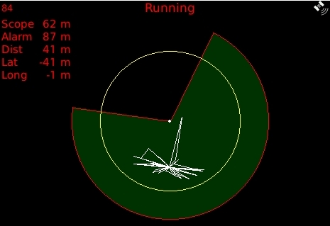
I don’t think I’ve ever seen such a sophisticated anchor alarm, and it’s an app called My Anchor Watch running on a Blackberry! (Thanks to Panbo reader Per for the head’s up.) The developer’s site explains the software well, but the features that really stand out for me is that “angle of exclusion” shown above and the SMS alarm capability…
In the diagram above, the white dot is the anchor, the white circle represents the scope of the anchor rode, and the red circle shows the alarm setting. Those are typical anchor alarm parameters, and you’ll get beeped if GPS shows your boat wandering outside the red circle. But a typical anchor alarm is no help when the wind changes and your boat swings, say, 180 degrees, which may mean your anchor will break out easily or that you’re too close to land or another vessel. That’s why My Anchor Watch lets you exclude a segment of the circle from the green no-alarm safe zone. Smart!
Another thing about a typical anchor alarm is that it’s set on a plotter, or sometimes even a radar, which is then draining your batteries at anchor. A cell phone is great for the purpose because you’d probably have it on anyway, and you can carry it around the boat with you (the problem being GPS reception next to your berth). A bigger problem with a conventional alarm is that it doesn’t help you when you might want it most, i.e. when you go ashore. Apparently, My Anchor Watch can deliver its alarm as an SMS message, though, of course, that would have to be to another phone.
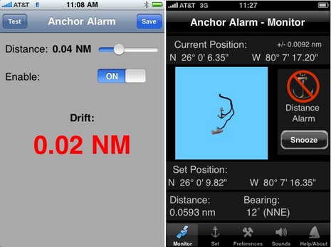
To my knowledge, there are two iPhone apps with anchor alarms, iNavX and Anchor Alarm (shown below). One of the truly powerful things about the whole iTunes app ecology is that either of those developers could add an exclusion angle and get into my phone in a few weeks, or another small developer might come up with an even more sophisticated anchor alarm and make money on it at a $10-$20 price (like the other stand alones), or maybe less. What the iPhone can’t do is that SMS alarm messaging (I’m pretty sure), plus you can’t run other apps while the anchor alarm is functional. Which are reasons why there’s room in this world for more app phones from the likes of Palm, Blackberry, Google, etc. I don’t think it takes much of crystal ball to predict that 2010 will be rich in phone applications for boaters.


Pretty neat design – the exclusion area and scope versus alarm areas are very well thought out ideas. It would be great to see these in handheld or stationary GPS/chartplotters at some point in the future.
While I agree having a chartplotter or GPS on is more draining that your phone, they are usually a bit more reliable and prepped for marine conditions.
Very clever, people are writing for blackberry’s great!
Android is going to be better for this stuff in that it supports multiple applications running at the same time. You won’t accidently turn off your anchor alarm when you receive a phone call or check email.
Next step … thru bluetooth or wi-fi PDA’s obtaining instrument information from NMEA-2000 (or 0183 if it must) and adjust the red zone based on wind speed and depth now vs. time of dropped anchor.
This is a pretty interesting app for us boaters. Last year I bought a simple Garmin 76 to use exclusively as an anchor alarm. It worked well, but I would have liked the ability to leave it on the boat and then have a message sent to another cell phone if my boat dragged when I was away.
Could have saved me some grief last year.
Though I am a big iPhone fan, I agree with Dan. This kind of app makes no sense on an iPhone, where to use the alarm you need to leave your phone set to this app all the time (and I don’t know what happens when the phone goes to sleep and starts shutting things down to save power). This is a case where background multitasking a la Android is crucial.
I think functionality like this should not be delegated to your phone, full stop.
My vote goes towards a small ‘server’ computing device consuming very little power (1 or 2 W) that will fire up the N2K bus once every 5 minutes for a few seconds to do some measuring, then email my phone with an update if it looks as if conditions are turning for the worse. That way it can tell me if position, depth, wind or water level in the bilge is over any limit I gave it.
I think that having an anchor alarm on your mobile phone is the perfect expression of using the right tool for the job. At anchor, I sleep with my phone monitoring our position (once per second). I have never had an issue with a variety of non-multitasking phones having any problem in doing their watch job over the 5 years I’ve been using them – and we anchor out a lot. Some of this depends on having the software written in a way that won’t allow it to go into sleep mode. Some phones need a battery backup in order to guarantee full overnight operation. This is all simple to do and very inexpensive. Google “powermonkey explorer” for a nice little device (with solar option) [no affiliation].
I have an iPhone and have used the couple of anchor alarms currently available for it. There are some problems when using them in a practical way today. First, sleeping with the iPhone next to you generally means that you’ll be below deck. If you remove the iPhone from a full, unobstructed view of the sky, it’s GPS performance turns to mush – hundreds of feet to hundreds of yards of error – if it can even get a fix. That is just unacceptable for an anchor alarm where you should be able to detect 15 or more feet of drag. Apple needs to allow Bluetooth GPS connectivity to fix this. Alternately, iNavX has a mode where it can receive GPS data over WiFi from a Mac with a connected GPS. That would solve the problem but now you need multiple devices powered all night and the MacBook’s aren’t low power consumers.
The exclusion zone above is a nice idea. In a practical way though, I don’t really care if I’m in the excluded part of the wedge near the center (if there is no wind or current). I’d care if I were X feet from the anchor in the exclusion area. That exclusion area shouldn’t be a pie wedge. If should be a bundt-cake slice.
Finally, there isn’t an anchor alarm available today that handles distance through swing around the anchor properly. Since the GPS is never positioned at the bow of most boats, there is an error of 2 times the distance from the GPS to the bow created by all anchor alarms like this. In many sailboats the GPS is on the stern rail producing a significant error and the reason why many people need to overset their anchor area on anchor alarms. As a specific example, a 45-foot sailboat will have 100 feet of error (2 * 45′ + 10′ GPS error) from the moment they start using their anchor alarm. Anchoring in 8 feet of water with, let’s say, 60 feet of line out means you’d need an alarm of 160′ to remove false alarm possibilities. That’s almost 3 times what most people would expect.
It’s time for a better class of anchor alarm – one that handles the GPS mounting location on the boat. With a heading indicator (standard on the iPhone 3GS), you can eliminate this mounting location error completely. I know that I’d sleep better with it.
Jeff nailed that — eliminating the GPS mounting location error, yes! That error is what makes the anchor alarm on my charplotter virtually useless (with my GPS mounted on stern, 39 feet from bow)
Also, Bluetooth GPS (not depend on your phone’s GPS), or if we can get depth and wind transmitted wirelessly from our NMEA-2000 or 0183 networks add the GPS. If just my mosts basic sensors were left on at night, no chartplotter or displays, I could afford the energy consumption.
While we are on a role, some other minor features:
– Alarm XX minutes BEFORE forecasted change of current direction
– Alarm on depth xx mph
– Alarm on MOB on NMEA-2000 (adds an additional noise source for MOB devices, plus mark the GPS coordinates and time of occurance, provide a bearing and estimated distance based on current set & drift which a boat at anchor would have available from its sensors)
Rather than an anchor alarm, it becomes more of a comprehensive reminder to wake up and attend to your boat under various conditions.
Sorry, gents, I’m not seeing where the location-of-GPS thing is a big deal. I do understand that a vessel with an aft GPS that’s laying to a current but swinging another way to the wind will fool an anchor alarm into thinking the boat is closer to the anchor than it really is.
But I don’t recall ever dragging anchor in conditions like that. The times I worry about are when it’s blowing hard and the line from anchor to bow to stern is straight. In that situation I don’t think it matters where the GPS is.
Re the GPS location at the stern, that happens to be the location of the most fragile underwater projection on my boat: my rudder, which is almost as deep as my 6ft keel, and far more fragile. Seeing as how the purpose of an anchor alarm is to avoid damage to the vessel and crew, what’s amiss with that location defining the swing limit, I wonder?
Actually Ben, it matters a great deal. As the boat swings around with current, the basic anchor alarm will think that the boat is further away from the anchor than it really is (especially when it is pulled hard away from the anchor). It causes a false alarm. This then causes everyone I know to set the anchor alarm for a much higher value than the amount of rode they’ve let out which doesn’t detect dragging as soon as you’d like it to.
The error becomes twice the distance between the GPS location and bow of the boat when the boat swings 180 degrees from it’s original orientation. At other angles the error is some percentage of 2x the distance.
One way to visualize it is to imagine the lat/lon of the GPS when the anchor is dropped. It isn’t the position of the anchor. It is back some 30 to 50 feet but the anchor alarm treats that as being right on top of the anchor. Draw that out and you’ll see – it’s twice that distance when you swing to the other side like we do in Maine a lot. I noticed it whenever I anchored in Maine. It bothered me that the GPS was good to a few feet and yet I wasn’t able to get 50 feet of accuracy through the night. It turns out that my GPS is 30 feet back from my bow and that was the cause of the error.
Doh! My thinking above was not exactly wrong, but it wasn’t relevant either. The problem I was missing happens when you set the alarm. If your GPS antenna is 40′ aft of your bow, the white dot in the top graphic is wrong by 40′ from the get go. If you swing 180 degrees, the alarm will think you’re 80′ further away from the anchor than you really are.
Big thanks to Jeff for an email explanation. He even send a document with diagrams called “Dumb Anchor Alarms”. He could have reasonably added “for Dummies”.
I would be skeptical of the accuracy of the GPS chip in a mobile phone or PDA, which is probably inferior to that of a dedicated gps unit.
On my GARMIN gps the minimum I can set the resolution of the anchor watch facility is 0.01 miles, which is 18.5 meters. If we add the uncertainty of the GPS position at – or + 10 meters, we have a dead zone of uncertainty of between 8.5 and 28.5 meters to start with, before the anchor can be considered to have dragged. For a 40 foot LOA boat, this basic uncertainty in position is between more than half and somewhat more than two boat lengths potential error.
FYI, We have looked at two anchor alarms, which are triggered by movement in the anchor not the boat. I have not seen the products in action, so can only talk about the concept.
An accelerometer attaches between the anchor and chain, and monitors the load on the anchor. If the anchor drags, it records a much lower load than when it is set. If the anchor unloads the accelerometer, send a signal through the transducer to the monitor.
Some calibration needs to be done to get the settings right. There is a range of load between the boat surges and this needs to be adjusted for.
However, the plus side is you can have a smaller radius to deal with than the large radius associated with a GPS alarm.
http://myboatsgear.com/mbg/product.asp?prodID=1864
http://myboatsgear.com/mbg/product.asp?prodID=834
Thanks, Mike! I briefly tested the Deep Blue Anchor Alert several years ago and it seemed to work as advertised, but I didn’t think the company was still around. They seem to keep a low profile, but I found their site:
http://www.deepbluemarine.ch/english/marine/
As for the one where you “weave” the signal cable into your anchor chain”, color me skeptical regarding its durability 😉
Also, I don’t think the Anchor Alert uses Bluetooth, at least not for the underwater connection. The accelerometer communicates using something quite like a sonar ping. Pretty clever actually.
Whether the details of the crackberry alarm are spot-on is important for that particular implementation, but as for the large-scale trend, Ben’s observations are, i think, the important take-away.
the accuracy of the location data in your cellphone varies depending on the phone model and whether its “location” functions are “real gps”, “augmented gps”, or just cellular triangulation. (Blackberry makes one of each, I believe.)
but again, the issue is programmability. Thes handheld GPSes have great location data, but since you cannot run 3rd-party applications on them, an ecosystem never arose around them which made them any more useful than the day you first unwrapped them.
it certainly took a while for cellphones to expose the considerable computing power they possess, but the eversion* has happened and we
are seeing the explosive growth that happens
every time something new turns inside out.
-mo
*(“eversion” is the mathematical term for turning something inside out, usually a sphere, without poking a hole in it. See Google for cool animations.)
As for the accuracy on the BlackBerry it is definately enough for this application. I tested the app lying along a quay for a night and unless the quay moved I am quite sure the boat was still :-).
The MyAnchorWatch for the BlackBerry application plots the position constantly, so in the morning we can see where we have been. Most readings were within 10 meters, but some readings slightly more. The BlackBerry was next to my bunk in a glassfibre boat.
That accuracy is enough for me. Maybe the BlackBerry has a stronger GPS than the iPhone?
Not sure about phones or other devices but it seems to me the right (TM) way to operate an anchor alarm on a plotter is either (a) to push a button when the anchor is dropped, and then another when the boat position is stable, or, (b) specify the length of chain plus distance to GPS unit, in this case the anchor position is determined using a heading sensor.
Better can be done taking into account the wind speed and any current.
Ben,
Check out http://www.g-fi.com. They sell a gps router. Rather then sending Internet info like a regular wifi router it sends gps information to laptop, iPod Touch, etc. It has a range of around 100′.
Jeff
I had a plan to use a Bluetooth GPS attached to a buoy floating over the anchor, but never got around to attaching a high-gain antenna to a Bluetooth interface.
Later I decided that yttrill’s (a) suggestion is probably The Better Way�. I may implement that next Summer as an experiment.
Jon
One big advantage of the sector alarm that nobody has mentioned yet is that especially during an unforecast wind shift, just because you’re not dragging doesn’t mean you’re not in immediate danger of getting hit by someone who is.
I was in Block Island last summer when a front passed through at 2AM breaking loose a Searay whose anchor snagged a 45′ trawler’s anchor and broke it loose. The trawler drifted within 10′ of me and the owners didn’t wake up until the Searay got his engine going and jammed it into reverse right before the trawler almost hit the boat behind me.
I had set my alarm clock because it was supposed to be a pretty strong front so I was up in the cockpit watching the whole thing happen when I felt the wind actually shift.
John K
I just used the iphone anchor alarm app for the iphone last week. I had not seen this blog entry previously, though I have to say the discussion pretty much nailed everything. What follows is the real life 1am-3am analysis! We had been out for weeks and I really wanted to get some sleep. My prior technique was to sleep on the salon couch propped up with my face next to the window.
First, I plug my iphone into a rechargeable battery pack that serves dual duty for my cordless drivers, flashlight, etc.. http://www.milwaukeetool.com/ProductDetail.aspx?ProductId=2349-20&CategoryName=SC%3A+Chargers
Without the extra battery, the iphone would not make it all night.
Second thing you figure out is the difference between your gps position and your anchor position. That happens right after you first nod off when the alarm starts blaring. But…this is where the graphic display helps. Because you can clearly see the arc of your swing, at which point you increase the range. Still, having the original point does help you interpret whether you have actually dragged or not.
I went shopping yesterday for a GPS to permanently mount on my nightstand. I can’t expect to hear the main GPS unit at the helm, nor do I want to run the power hog puter with Nobeltec. The sad thing is tht nothing I found on the market yet actually seems to provide the same iphone capability in a small bedside package.
I’m not wondering about N2K and a small bedside MDF that could monitor my position among other things. I somehow expect that what I’m looking for may not exist yet.
Sad, because that simple iphone app let me sleep better than I ever have during a windy night at anchor (always set anchor upherd of the crowd, that way nobody comes crashing down upon you).
Dear Santa,
I have been really good this year. Ok, not that good. But what I would really like for Christmas is a useful anchor alarm for my existing GPS hardware, and this is not a big request. To get an effective alarm, we need to center a circle (or some other shape) over the anchor with the correct swing radius. But this can be difficult for a number of reasons: (a) as others have pointed out, the GPS antenna is usually mounted far aft of the bow, and never directly over the anchor, (b) the GPS software “sets” the anchor waypoint when the alarm is activated, and it might not be practical to press the button when dropping the anchor, and (c) even if you could get the antenna over the anchor and activate the alarm at the right time (as one could with a handheld GPS), the anchor will probably drag before it sets … sometimes a lot.
What’s a not-so-good kid to do? One simple solution would be for manufacturers and software developers to provide a software fix that “un-hides” the anchor waypoint. With all of my equipment (Furuno, Garmin, MaxSea, MacENC), the anchor alarm is set by creating a “hidden” anchor waypoint, around which the user specifies the swing radius. If we could access that waypoint, its coordinates could be changed to move it to its correct position over the anchor. That way, even after the anchor is set, we could take a bearing on the anchor, and calculate the swing radius based on anchor depth, scope, height of the bow and distance of the GPS antenna from the bow. Or, the anchor position can sometimes be set using the GPS track.
A more flexible solution would be to modify the GPS or plotter software to allow us to specify either exclusion or inclusion zones for every waypoint. All of my software allows me to set proximity alarms. That is, an alarm is triggered if the GPS antenna enters the alarm radius. But an anchor alarm needs the converse, namely to trigger an alarm if the GPS antenna leaves the radius. If we could specify an inclusion zone, we could simply estimate the anchor’s position, then set a waypoint and swing radius … even after the anchor was set. If both types of zones were available, we could even set up Jeff Siegel’s “bundt cake.”
In the meantime, there are a couple ways to make our alarms more useful. I usually use a handheld GPS and activate the anchor alarm while directly above the anchor, and specify the swing radius. Then duct tape or 5200 the unit to your ear so you can hear the alarm if it goes off (another pet peeve for another post).
The second way is to fool our GPS’s into thinking they are effective anchor alarms. After the anchor has set, estimate its position by taking a bearing on it and calculate the distance from the GPS antenna. This is the center of the “circle.” Then set a number of proximity waypoints around this center so the tangent of their alarm radii lie just outside the vessel’s swing radius. For example, setting 8 proximity waypoints every 45 degrees effectively create an octagon (instead of a circle) around the anchor. When the vessel gets near one of the waypoints, the alarm sounds. A pain in the neck to set up, but makes for a good sleep.
Any feedback or other suggestions would be welcome, and I promise to be better next year (sorry for the long comment).
Very interesting thread. I have to agree with Kees – a NMEA2000 device that grabs the GPS location from the network and then uses a tiny bit of power to let me know the boat moved makes alot of sense.
I have a spare USB to NMEA2000 interface so perhaps I just found an app to write over the next few weeks.
I’ve been working on a a web app that allows you to use your existing hardware (smartphone, tablet or computer) to track your boat’s position while you are onshore. It’s been tested on Android phones, iPhone, iPad and even an onboard Windows computer.
You can log in to the service using a web browser for free, and see your boat’s position on a satellite map.
http://boatmonitor.com
You have some nice apps. in Android Market for anchoring alarm that works nicely and are simply to use, in Android OS you just activate alarm and jump to home screen, the alarm is active until you switch it off of run out of battery.
My company just released one app for that, it is free with adds, or paid (adds free), and basically looks like the one in this post, with optional exclusion sectors (free version only allows circular safety zones, paid one allows sectors) but also allows you to set the radius and sector using a satellite view from google maps.
It alarms you on GPS signal lost (for more than 1 min.), on https://play.google.com/store/apps/details?id=net.hcsoft.sailsafeFree