
Humminbird downrigger control, really different
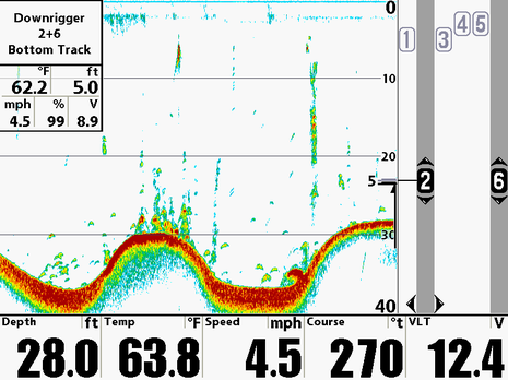
I could easily write a dozen more entries on 18″ radomes, AIS, NMEA 2000, and iPhone apps, but how about something completely different? I received and bench tested a loaner Humminbird 1197c this week. My plan is to check out its side-scanning abilities, particularly now that Lowrance is challenging its dominance in this niche. But I couldn’t help but notice the rather amazing downrigger controls shown in the machine’s demo mode. The screen above shows one of three downrigger pairs being automatically positioned 5 feet off the bottom as my simulated boat trolls a wavy bottom. And there’s much more…
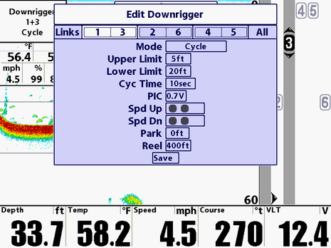
For instance, another downrigger or pair can be made to “cycle” up and down at a specific depth and speed. Or a user can just manually control his/her baits or jigs from the MFD. Not surprisingly, this “fishing system” only works with certain Canon downriggers, and a special interface box, all developed by Humminbird’s parent company Johnson Outdoors, but still have you ever heard of a plotter managing anywhere near this level of mechanical activity? And now that you have, what else could an MFD do?
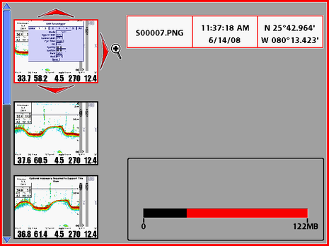
The 1197c also seems to pleasingly fast, and loaded with interesting features. Below, for instance, is the best sonar recording and screenshot display (and management) page I’ve seen on any MFD (and, thankfully, they almost all at least do screenshots these days).


The inverse of this would be nice. Have your MFD control throttle & steering in concert with your AP in order to follow & troll a particular depth contour. Or have the downrigger raise & lower in response to fish detected by the sounder. Or have the MFD calculate drift due to current and wind then control course & speed so as to keep your boat stationary over deep fish holding structure. Or . . . just a fish catching video game so you don’t even need to leave the dock?
Very interesting. If an MFD can control down riggers why not an auto pilot (heading), boat speed and or engine RPM, etc. Perhaps some fail safe features could also be included. If approaching a grounding or collision situation it could sound an alarm and reduce RPM.
Limits of the imagination?
Butch
Ben, when you do your testing, would love to see what happens if you align the transducer as normal and then just rotate it forward (that is, with the axis of rotation athwartships) about 45 degrees…
/adam
I have an earlier model of Humminbird with six transducers building a bottom map for display. Since GPS data is present, I found it disappointing that the system does not pace or sync the display refresh frequency with the rate of forward progress. Currently, the display of the bottom is compressed or stretched based on speed. The user is always forced into mental compensation for this distortion. This is also true with the side scan mode unit. I call up about once a month and beg for this feature, since the data is in the box. Just pay the software guy once and have the feature forever.
Roy
Dang, no interface for Scotty.
What else can an MFD do? How about keeping a log of depths, positions, and tide references, to be downloaded and forwarded to a central collection site that can provide corrections to nautical charts! The data could be used to flesh out areas that aren’t regularly surveyed, provide correlation for satellite mapping, include comments on bottom makeup, and surely more!
(OK, I won’t call you shirley any more.)
What else can a MFD do???
I really don’t want my primary chart display to do anything else. A 22″ monitor is only just about big enough!
Michael Porter
Sandy, the Olex chart system (olex.no) collects data by default and has been doing it for years. The data is made available to all users. From what I heard, it’s of good value.
+1 for Olex system.
Very impressive over 30gb of collected depths from different users.
Now impressive multibeam data coming into the system as well.