
Cruising with an iPhone, Navionics Mobile 2.2
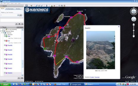
How cool is this! Most of the time we were hiking Long Island over the last two days I had Navionics Mobile 2.2 (East Coast) running on the iPhone and in track mode. Thus I could use it to check our progress against the trail map (downloadable here). I also took some iPhone photos of the mossy rich and rugged scenery from within Mobile, which then geo positions them on the chart. That’s all neat, but the true kicker is that I could easily email the whole track with (reduced) photos to anyone as a KMZ file (only 248k, downloadable here) that can be overlaid on Google Earth as shown above. Or, with only two touch commands, could post it all on my Facebook page, where it seems to link to a Navionics-served Google Maps file which you may be able to see even if you don’t have Google Earth or don’t know beans about Facebook (like me). This easy track and photo sharing is great, but in fact the iPhone has been useful in many ways on this cruise…
Until we got a mooring with good WiFi (thanks to the crackerjack Lunt & Lunt operation here — which also served us the meatiest and possibly tastiest lobster I’ve ever eaten (and that’s a large sample) — the iPhone was our only tool for checking email, seeing weather radar, and other online tasks (like moderating Panbo comments). The somewhat embarassing truth is that I’ve gotten into reading news sites on the iPhone in my berth at night, which saves 12v juice (don’t have an LED there yet, and can charge the phone when underway or running the gen set).
And the fact is I’m not even using the phone to its fullest yet. The latest version of iNavX, for instance, has an anchor watch mode (plus true routing, and wave heights added to the GRIB overlays). I’m just downloading direct to the phone now (maybe, as only Edge service here). I did manage to install a new app called the Boater’s Pocket Reference and am impressed. I’ve seen most of the material on its 1,800 little pages before, I suspect, but it is darn handy to have it all on an iPhone, searchable and book markable. If it keeps raining, I may retire to my berth and learn some some exotic knots.
And Lord knows we’ve all just gotten started with clever smart phone apps for boaters. For instance, EarthENC — which made NOAA raster chart overlays available, like for Long Island — is promising phone apps soon. And I very much look forward to what Active Captain — now sporting a much improved Web site (registration no longer required to see postings) — has up its smart phone sleeve.


Apple “gets it”. The marine industry doesn’t get it. Seeing apps on an iPhone impresses: wow! cool!
Compare this quote about a potential Apple product for example:
Assuming its computing powers and interface design are anything like the iPhone’s, a touchscreen tablet would make these student-oriented tasks as easy as a few swipes and taps — far more pleasant than clunking around with the Kindle’s cheap buttons and sluggish interface.
http://www.cnn.com/2009/TECH/07/28/apple.tablet.amazon/index.html
Marine MFD’s buttons may not be cheap, but clunking around with buttons and a sluggish interface sounds familiar. Touch screens have lots of potential, but that isn’t enough, there needs to be a nice user interface. No marine company allows users or outsiders to design and implement apps or pages on their system if the users don’t like the ones provided. Please tell me I’m wrong.
I am a new iPhone user 3G and have played a bit with Navionics. The touch screen apps often do have on screen buttons and I don’t see them as any different than soft keys on MFDs. I find the RayC80 user interface very poor. I know I can get to things, do things, but I can’t remember how and I can’t be bothered to refer to their manual.
iPhone apps are very basic but the interface seems to work. I am not thrilled with Navionics yet. I’d like more control of the track line and the course / heading line – color thickness etc.
I’m used to a hand held plotter -iQue and find the Garmin charts superior and I have a mount for it which makes it more useful on a sailboat.
Having said that, the SUM of all the apps… not only marine makes this a very powerful tool. We were playing scrabble one night on the mooring and needed a dictionary. Downloaded one for free in 15 seconds. How bout that!
Also, I installed the tethering which allows me to use the iPhone as a modem and the laptop and charge it at the same time, while using juice from the house bank. I can’t do very well with the silly little virtual keyboard so sending email is limited. But I can send pics and the geo positioning is cool. I did use the internet in the middle of Block Island Sound to look for weather and check on when the Independence fireworks were scheduled for Newport.. That was cool. Tethering is not too speedy, but considering that it works at all to me is a miracle.
I think the iPhone is a neat gadget which gives you access to incredible resources, if you need them.
Now if it were just waterproof.
Ben,
So glad to hear you’re enjoying our App… it is a lot of fun. There’s so much more coming with the next version, 2.3. But before I mention some of the new features coming to you and your readers… let me first offer your faithful followers a FREE PROMOTIONAL CODE so they can download one of our Apps at no cost, and experience it themselves first hand… with only the hopes that they’ll share their experiences with their online audiences. (Requests should be made to [email protected]. A limited number are available, first come first served).
Now about those new features coming with 2.3 coming in August�
Users will be able to enter lat/long coordinates with our new GO TO feature� that�s one that�s been heavily requested� glad we can accommodate so quickly. Another cool feature� you�ll be able to set your markers and choose from four different marker icons. Now you can easily differentiate between your fishing hot spots and your favorite anchorages. Another big request has been a button to lock the screen to prevent the iPhone from going into sleep mode. Of course your iPhone contains this feature already, but with 2.3 we�ll be providing users with a lock button directly in the App. There�s more too� stay tuned iPhone users!
Just finished a cruise up to Maine and found that AT&T iPhone service is poor east of Portland. When you are used to 3G everywhere and five bars of signal all the time in the NY area having to wait for E signal is excruciatingly slow. AT&T has not invested in the same infrastructure for coastal Maine as they have in other areas compared to their competitor Verizon. Also, we found many anchorages with WiFi signals but almost all are locked or fee based. There should be a campaign to have one fellow mariner in each harbor host an open WiFi hot spot for cruisers, (supported by a few local Main Street ads).
During our cruise, the weather apps especially Radarscope V1.3.1 by Base Velocity, LLC saved the day. VHF, NOAA marine weather has been degraded to useless, in my opinion. There’s just too much, “What happened yesterday”, “What’s the weather now”, (I can see that by looking outside) and “How to save yourself from stupidly going swimming during a raging storm”.
By the time NOAA gets around to the forecast I can check three iPhone weather apps and throughly understand what on the way.
I’d love to have the anchor alarm from iNavX, but I have no use for the US charts so $50 is way too much for an anchor alarm.
Russ, Using X-Traverse you can get an amazing number of charts for iNavX, often quite reasonably priced too.
https://panbo.com/archives/2009/04/fugawi_inavx_navionics_the_pieces_come_together.html
I’ve tried the anchor alarm a little, and it’s a nice implimentation. I’m a little dubious that the GPS in the iPhone 3G is accurate and consistent enough, though. The 3G-S might be better.
SanderO, Are you tethering a 3G with AT&T data service? If so, please tell me how you did it.
Richard, You’ve made me glad, in a way, that I’ve rarely seen 3G service on my iPhone. I find the Edge service tolerable, though I did find that I just couldn’t get it to download NOAA raster charts to iNavX. I should have loaded the ones I needed when I was on fast WiFi.
Ben,
Yes I am. An ATT sales guy suggested it when I was about to buy a air card. It’s not strictly legit, but it’s not illegal either. So I bought thr iPhone and gpt all the neat apps and so forth – an Ipod, camera etc. The air card is $60/mo and my phone plan is $75. Good deal. Tethering is already IN the phone, you just are turning it on. Rumors have it that ATT will soon charge between $5 and $30/mo but for now if you open the feature, it’s free. It’s cool but not broadband speed for sure.
I went to CNET and they had a tutorial. It’s quite simple. You need a 3G running 3.0, and itunes installed on the computer you are tethered too. It takes about 10 minutes to download the file from the net.
One thing which I would like to see in Navionics is the ability to have course up. I find the north up is not always the best one to use when you are in close quarters and trying to verify what you eyes are telling you.
I hope to do gribs on the iPhone one of these days.
The tethering function is available in the iPhone OS 3.0 and newer, it just needs to be enabled. Here is a description of a nice site that will do this for you:
http://www.engadget.com/2009/06/18/how-to-tether-your-iphone-running-os-3-0-without-jailbreaking/
Standard disclaimers apply, backup your phone first just in case…
While tethering is enabled as of 3.0 in the iPhone, AT&T specifically prohibits it in the TOC and reserves the right to either cancel your service or charge you for additional use. The legality of the prohibition has yet to be determined. While AT&T has said that tethering will be enabled “sometime this summer”, they have not committed to a date nor have they said why it is delayed. I would suspect that with the recent FCC interest in the mobile industry, AT&T is feeling a little pressure to get on the stick regarding this and other issues.
Having said that, tethering works great (….or so I’ve heard from folks who have installed a tethering provisioning config for AT&T). Be aware, tho, that you do run a risk by installing non-signed SW onto your iPhone.
Bob Etter
Thanks for the complimentary Navionics region! It looks like a very well executed product. Amazingly feature rich. It’s really great to be able to zoom in on islands we’re planning to visit next winter while sitting in a wine bar!
Thanks again!
Ben,
Just a quick note to express my gratitude to your wonderful audience of followers. We received numerous requests in response to our offer for a Free promotional code to test drive our Mobile app for iPhone, with only the hope to receive some feedback and suggestions on the additional features savvy users would like to see in future updates. Not only did we get some great suggestions, but we received more positive feedback and complimentary comments than we could have imagined. Thanks Panbo�ers! Watch for similar opportunities in the future.
Navionics
The Navionics Mobile app is a great compliment, and emergency backup, to the Navionics data on my E-80. In fact, it was the Navionics Mobile ad on panbo.com that provided the final push for me to get an iPhone. Navionics should get a commission from Apple and at&t for selling two phones (my daughter got one too).
However, I rushed to load the 3.0 update last week and lost access to all of the chart data. All I see is a very crude shore outline.
Navionics has fixed this problem and is waiting for Apple to approve version 3.1. The problem does not affect all regions, but it would be wise to wait for the update if you depend on the application.
Jon
I agree with the great comments about Panbo and Navionics. My wife and I use the iPhone and the Navionic Mobile App on our houseboat, and it is a fantastic tool to help use get around the bays and shallows.
I find that we use it often in the dinghy, while we’re exploring new areas and bays.
I am hoping that Navionics continue to future refine and add new features, since many of our readers on our houseboat website carry iPhones and would use such a small mini chartplotter.
Thanks for the great review.
IAN from http://www.all-about-houseboats.com
The 3.1 update became available today and I am happy to report that all is well again.
Jon