
Raymarine C Series Widescreen, really new
All hail Richard Brain. While the Consumer Electronics Show, year-end “best new…” lists and patent searches may all offer 2009 marine electronics possibilities, the real deal—mainly a passel of very interesting Raymarine preview products—is being shown at the London Boat Show. And Richard was kind enough to collect brochures, photograph them, and email them to me for your Panbo pleasure. So let’s thank Richard and say hello to Ray’s new “Widescreen” C Series, which is truly different from the original…
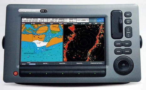
Raymarine has been very quiet about this and other developments like the unique Class B AIS500 transponder and the cool large screen ST70+ instrument system (you’ll have to wait a day or two for), but there is a Widescreen press release on the UK site. There you’ll learn that the screens are not just wide but quite high res: The C90W packs 800 x 480 pixels onto its 9” diagonal display while the C120W sports 1280 x 800, which is the same pixel count as the whopping 14” C140W. And these new Cs aren’t single station; the inclusion of SeaTalkHS (Ethernet) mean that at least two can network directly, and lots of HS sensors can be added with an eight port switch. Now included amongst those Ethernet sensors are new 18” and 24” “Digital” Radomes, which are both 4kW and apparently perform better than Ray’s current domes (which work quite well in my experience).
Like the relatively new A Series models, the Widescreens include built-in GPS and basic Navionics cartography (with most premium cards supported) and SeaTalkNG/NMEA 2000 (hopefully with the promised N2K message fixes and improvements). They can also control the SPX (N2K) autopilot series, display camera output, and have a new button lay out that includes that large “UniControl”, said to be quick and easy at cursor and menu scrolling moves. I don’t know anything about pricing and shipping dates for the Widescreens and Digital Radomes—or the goodies yet to come (thanks again, Richard)—but dare guess that more will be revealed in Miami next month. The question that may remain unanswered: If the new C Series is this powerful, what the heck will Raymarine add to the new E Series?


Aha; Richard has a price list too. These are in Pounds, without VAT (sales tax):
C90W, 1,595
C120W 2,195
C140W 2,995
Digital Radomes with no cable:
RD418D 850
RD424D 1,250
I thought the Unicontrol UI on the new C Series was horrible compared to the old C and E Series. The ST70+ were things of beauty though. The guys on the stand also said:
-Digital raydomes next month
-HD Digital raydomes – Aug / Sept
-Wide screen e series next year.
-E and C series cannot be networked
-New C Series cannot utilise all of the platinum chart features.
Here it is in USD
C90W, 1,595 – $2368.58
C120W 2,195 – $3259.58
C140W 2,995 – $4447.59
Digital Radomes with no cable:
RD418D 850 – $1262.25
RD424D 1,250 – $1856.25
Can we expect the usual RayMarine rebates??
Assuming you can still superimpose Radar and Weather on a full screen chart, You could mount these units sideways and see more of where you are going and less of where you aren’t. Or maybe there is a “course sideways” setting instead of a “course up”.
I’m betting “digital radar” is not “wideband”.
With Raymarine the weather isn’t superimposed on cartography, rather it goes in it’s own window, 1/4 or 1/2.
It’s much better that way as in practice you want the weather zoomed out while the cartography is zoomed in closer. For example if you keep the weather window zoomed out so that it’s 150 or more miles across the window … you can keep an eye on weather changes and t-storms heading your way … while cartogarphy is zoomed in to show depths, lands, buoy’s, and other features much closer, … for me usually less than 6 miles across.
My e-series default page I use while underway is configured to show cartography on the left half of the screen, weather in the upper right 1/4 screen, and data values in the lower right 1/4 screen. When I am searching the map or building a route, I switch to full screen cartography to do that, and then back to my default view.
If you setup your databar (the narrow bar across the top of the chartplotter) to include lat/long/bearing/distance of the cursor … then when you move the cursor along the weather screen to a t-storm or other weather feature, you get the distance and bearing instantly.
Ben, I know you said that there would be more to come … but I found the following site
http://www.jgtech.com/shop1.htm
It seems to say that the Raymarine AIS500 Class B AIS Transponder has a STNG (Read N2K) connection … would this not be the first N2K Class B Transponder … and maybe even the first N2K AIS Transponder (A or B)? The FA50 has NavNet but no direct N2K.
Simrads class B has N2K (simnet) and works great if your plotter can receive AIS N2k PGN’s which Furuno’s Navnet 3D currrently cannot. Luckily (for me) the Simrad unit has an 0183 out as well. The unit can connect to a N2K vhf (i think Simrads is the only one out there)and make DSC calls by selecting a vessel on the AIS display.
I count three brands of DSC N2K VHFs so far. Simrad RS82, RS86, RS87, Lowrance LVR-880, and Garmin VHF 200. Now where are the official PGNs to link these with N2K chartplotters and N2K AIS?
The Garmin isn’t actually shipping yet. 2Q09.
For NMEA 0183, I suppose that the Icom MXA-5000 receiver approach is pretty good marketing aimed at the installed base.
But for NMEA 2000, it seems possible that one of the players might go for a home run with a combined VHF/GPS/AIS Class B transponder. Having the AIS transpbonder onboard would make the VHF splitter much simpler. Lower power, smaller footprint.
It will happen eventually.
My question is are they upgrading the “inards”, ie, processor and graphic chips. The E series seem to be processor deficient it just doesnt have power to effectively handle the tasks that are given to it. Such as fast redraws – no waiting for the chart to catch up to the boat.
Anonymous … maybe if I saw a time zero demonstration (I have not) … I would think otherwise, but I thought the redraw times were good on my e-series, then got noticably better with the new software release early last year.
Have you loaded the new e-series software from early last year?
Just back from London boatshow have to say the new C series and A series are probably the ugliest displays I have ever seen. Whilst the new Lowrance HDS and newer Garmin displays look quite stunning Raymarine seem to have been caught in a plastic time warp – software on the HDS is far more advanced and with Broadband radar option I have to say it is a straight choice between Garmin and Lowrance for me.
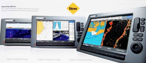
Raymarine just updated their website with the new C-Series Widescreen models. They come in 2 versions with charts included for either US or Rest of World.
I wonder if, since they can now support 2 units networked together, one can buy one of each and have all the US and World charts shared between the two units.
What they don’t say is that Raytech 6.1 RNS does not support the new widescreen c series. I have recently bought a C90W and Raytech 6.1. As I have been used to Laptop based navigation software (Seapro) I thought and was recomended by a UK dealer that this would be a good compromise having C90W in the cockpit and laptop mimicking the plotter below.
So imagine my disappointment when phoning Raymarine support today that they tell me it is not supported yet and probably not for another YEAR! Come on Raymarine you can do better that that?!
However on the plus side I do get the charts from the plotter transferred over to laptop when connected via ethernet, but am unable to to transfer routes and waypoint to the C90W via ethernet.
Other disappointments:
The power/signal cable supplied is only 1.5 meters long which is not enough to go from the pod down the tube to below decks and into a watertight junction box. 2 meters would have been just right! There are nineteen wires to extend now.
The Raytech software needs to be started AFTER the the plotter has booted up otherwise the charts won’t be transferred. So don’t switch the plotter off and on either unless you want to restart the laptop application again.
It is not clever enough to reconnect when connection is lost. I also note that compared to Seapro for example it seems to take large amounts of laptop CPU not doing very much.
However in general I quite like the C90w, so far as I have tried it on my desk at home…..
Ive just bought a C90w and C120w to be used on lower and upper helm stations. I wanted to buy the Raytech software but am now hesitant. I am not too fussed about the ethernet connection for now, but would like to know if I can do my planning and waypoints at home and then transfer them to the displays via the compact flash cards?
Can someone please clarify?
You do not need the Raytech software to do planning from home, you can use any navigation program you like (eg; SeaClear, OziExplorer, etc) and then transfer the waypoints to your Raymarine chartplotter using a CF card. Do not use the one with the charts on it, you risk damaging it.
There are a couple of utilities that can be used to convert waypoints between different formats, GPSBabel is a great free utility that supports pretty much all formats, and Raymarine also provides their own one that converts from an Excel spreadsheet to their internal format: PC Waypoint Utility (http://www.raymarine.com/default.aspx?site=1&Section=3&Page=900&Parent=3)
Of course it takes a bit more work to do it this way, but Raytech is not cheap and it is nice to have a choice…
Victor, RayTech 6.1 Planner Version is free, and I think you got a CD of it with your C-Series. You can also download it from Raymarine (though you may need to register as an “insider”, which is worth it anyway):
http://www.raymarine.com/default.aspx?site=1§ion=2&page=1890
I don’t think RayTech runs on Vista, though, just Windows XP/2000. I haven’t used it in a while, but it worked fine for route planning when I did:
https://panbo.com/archives/2006/06/raytech_60_first_impressions.html