
Garmin at FLIBS, 640 & GWS 10
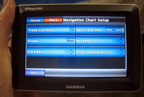
Garmin had a working GPSMap 640 at FLIBS, and I found a couple of nice surprises on it. One is that it does AIS plotting, which wasn’t even mentioned on the press release. More important really is the improved touch screen interface. Notice the status labels on the big buttons above; in cases where the only choice is on/off, like Tide/Currents, just tapping the button changes the status. Which beats the hell out of the norm on most Garmin marine units, i.e. tap (or soft key, or Enter) for another screen, choose between on or off, go back to original screen. On the 640, it’s one tap instead of three (or four, if you don’t have touch or soft keys).
Then are variations like Service Points; the slider is a simple on/off while the pressing the main button gets you to details. This all may sound trivial but I once joked that one day we’d know the owners of (non touch) Garmins by their weirdly over-exercised thumbs. There are lots of ways touch buttons and soft keys can be made more efficient and informative (as suggested on the HDS screen), and I was glad to hear that this and other 640 interface improvements will eventually make their way into Garmin’s larger marine units.
Speaking of touch screens, did you notice last night how gleeful the CNN election announcers were with their giant multi-touch map screens? Given that, and iWhatever, and Garmin’s 640/5000 efforts, and Planar’s bright screens, won’t we be seeing a lot more touchy marine products?
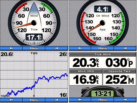
Now, about Garmin’s GWS 10 wind sensor: I’d seen a beta of wind-related GMI 10 screens at the NMEA conference and at FLIBS I was handed the neato screen shots below. As I understand it the full wind rose at upper left can be set to automatically switch to the downwind gauge upper right, or a close hauled gauge, when you go to that point of sail. Obviously strip charts are available, as well as that timer seen lower right. And I’m told that the GMI update that includes these wind screens also fixes the page limit and customization issues I bitched about when the GMI first shipped.
Garmin also kindly researched the question of screen brightness versus power consumption, of some concern to sailors attracted to Garmin’s new wind possibilities. Here’s what they told me: With a boat’s battery at exactly 12.0 volts, a GMI 10 at 100% brightness consumes 226mA (or 2.7W), 50% brightness = 123mA (1.5W), and 0% brightness = 93mA (1.1W). And “the current can be calculated for any input voltage by dividing the power (wattage) rating by the voltage. What do you watt-watching sailors think of that?


I think that the user interface on MFDs is a byzantine. For example I am still relearning to use the Raymarine C80 each spring as finding commands is usually buried deep inside of of a layers of menus and required drilling down to find what I want. My biggest beef is getting the thing to display what I want and and the scale I want. One has to use a toggling soft key to move from “cursor to ship’s location” and if you scroll (ICK) you often have to redo it because the toggle is on the wrong choice.
When working with paper charts your eye moves to where you want it and your brain focuses on the area of interest. Doing this on a the plotters I have Horizon and Raymarine make me feel like I am programming the movements of my eye.
On the other hand the IQue interface offers a second type of panning and zooming in addition to the “fixed” scales achieved by button pressing. That is to draw a “marquee” of the area of interest with the stylus. The screen is then instantly redrawn centered and fit to the marquee. Panning is the same. One doesn’t have to increment orthogonally.. you just push the stylus in the direct where you want to see.
I won’t go into finding other commands on the C80 and the multiple steps one needs to get there. Of course this is a consequence of stuffing oodles of commands into a few switches or buttons. I don’t know the solution here, but the GUI sucks on the Ray and the Garmin.
I find I use the simpler hand held device more that the fixed mount for multiple reasons.
How about a blue tooth feature for the hand held to receive and show radar overlays from a master unit! YUMMY.
I’ll agree that the Raymarine UI is highly confusing and non-intuitive, ie “bad”. Despite some areas of better technology, its the major reason I didn’t buy Ray products.
But I disagree that current Garmin interfaces are Byzantine or that they “suck”. No doubt we’ll see improvements but current versions are generally very straight forward to operate and quite handsome, IMO. It’s easy to find information and make adjustments.
I’d like to see Garmin do a better job in the documentation department. Their manuals skip over many functions, the meaning and purpose of settings, and explainations of how best use certain technologies (fish finder features / settings come to mind).
On a wireless link of data from a main unit to a 640 via Bluetooth – you’ll have to wait a long time. Bluetooth simply isn’t designed to handle large amounts of data, or to handle fast data transfers. That’s why it’s perfect for a cell phone headset or to connect a laptop to a printer. For something of that nature you would need a version of WiFi to link the units.
So, I figure a set of four GMI 10 instruments would use about 14 Ah per day. That means the boat has to carry about 20lb extra battery weight. Not a big deal for a cruiser, but a racer would have to think about it.
Ben,
I was starting to compare the numbers to other devices I am familiar with.
When comparing to the Raymarine ST70, these Garmin numbers look very good. The ST70 spec on the web-site lists 220mA. How does Garmin get so much brighter for about the same power? Did Raymarine overstate there power in their specifications ? Garmin display element technology is more power efficient?
When thinking if they have enough power, I would think most people would compare the Garmin display to what they have now, might not be enough information here to do that.
Ben, do you know if the Garmin number excludes, as I suspect, the following:
1) Power drawn from through the N2K bus? I recall there are separate power leads for the display rather than drawing all the power from N2K. Possibly, for reasons of power isolation, the guts of the Garmin other than the display … such as the components that read/write to the N2K bus … might separately draw power from the bus. That might add another 25mA or more on the numbers Garmin gave you ?
2) Power drawn by the wind sensor. While previous generation equipments power consumption like a Raymarine ST60+ would be inclusive of the wind sensor, which uses practically no power at all, a wind sensor on an N2K bus has many of the components that use to be in the wind instrument. E.g. the wind sensor needs to measure the wind, perform the math to convert from apparent to true, listen for SOW and configuration data and transmit wind data over the N2K bus. That might be another 25mA, or maybe much more, right?
I have been giving this some thought.
At first I was thinking this is a tremendous amount of power (3 displays + sensors, etc. in the 1000mA range) vs. prior generation of displays and sensors consumes about 150mA for depth, speed, wind. Thats 6X more power over the previous generation.
That is certainly a lot of power for a Rhodes 19 sailboat, many of which don’t even have a battery and where a solar power Tacktick would be ideal, but I think this kind of power could be justifiable in a wide range of uses.
There may even be a power saving angle to this for boats that could support an 8 inch or larger chartplotter. Rather than having an 8 inch chartplotter with part of the display dedicated to data numbers your traditional displays won’t show, like COG, SOG, distance to waypoint, time to waypoint, etc. save power overall by using these new Garmin displays (and their Raymarine equivalents) for this data and go for a smaller charplotter. The combination could save quite a bit of power. For example a chartplotter like the Garmin 545S (1000 mA), 3 Garmin displays, and the sensors connected over N2K would use less than 2,000 mA. Not to shabby. While your at it, mount these Garmin displays in the front of the cockpit so everyone can see them, not just the person at the helm.
I just wanted to comment on how impressed I have been on Garmin into the marine end in the past year. I noticed comparison, above, to the ST70’s. Is that even fair to compare to a product you cant even buy? Last time I checked, about a week ago, Raymarine recalled the ST70’s and could not even provide an eta on when they would be back again.
Also noted above Garmin is way user friendly and I do agree the manuals are not as good as they could be, but customer support is exceptional.
I dont want to trash other companies, I am a big fan of Raymarine. Still Garmin has the potential to become the leader in marine electronics. Their products seem to be in another league compare to some of the competitors.
I guess time will tell.
I wasn’t being fair in regards to the GWS 10 / ST70 ? To who ? In what regard ?
Putting aside that I have been using an ST70 on my boat since June, I am re-reading my comments and don’t understand your comment in regards to fairness Mike P.