
Speeding w/ Simrad, tracking w/ Garmin

That’s me in the tan shirt, aboard the 34’ Yellowfin (run by pro Mark Maus) that Simrad used in Miami to show off its new GB40 and NX systems. I’d already covered their introduction in PMY, here and here, but still have a lot to learn about their details. The demo trip wasn’t a particularly good environment for studying details, but I did learn that both can keep up a pretty good plot even at 63 MPH! Eventually I’ll write more about the monster install in that center console, but today I want to discuss tracking that personal-fastest-ever boat ride with the test Garmin Colorado that was in my bag.
As you can sort of see on the MapSource Trip & Waypoint Manager screen below, and bigger here, I’d first turned on the Colorado while in a cab crossing the Venetian Causeway, then carried it around inside the Miami Convention Center, and finally to the Yellowfin a few blocks west. It was easy to later make the USB connection to my laptop and download the track. But there’s almost no map detail to see it on, which is a problem now that most people get their BlueCharts either built into a plotter or on a card (as MapSource doesn’t read cards) . Back in the BlueCharts-on-CD days, unlocking regions and burning your own cards was a hassle but it did mean that you could do PC planning right on your plotter charts. It’s funny how Garmin was the first—and for a while, the only—company that supported this feature, but now C-Map and Navionics are both arguably ahead with their C-Map Planner and NavPlanner products, both of which have been updated recently (more to come on those). Now Garmin does offer a (continue below the image…)
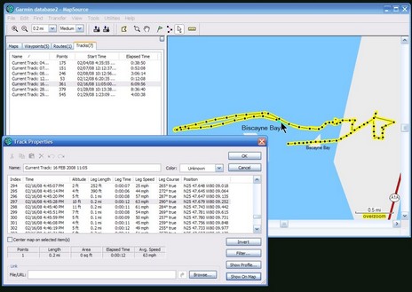
a link from MapSource to Google Earth, which gives my speedy Simrad demo a nice photographic context (bigger here). But it’s not suitable for planning voyages on, and I’ve got to believe that Garmin will eventually come up with some way to make PC planning possible for all the folks who their charts built into plotters and handhelds. I say that not just because Garmin is Garmin, but because I’ve looked at what they’re up to at Garmin Connect and also with Mobile PC, both of which make MapSource look pretty old school. Come on, Garmin, how about a sleek marine planning program, even a PC navigation program?
![]()


i like the idea, a pc navigation program that is a nice idea.
jc.