
Tacktick Micronet, part 2
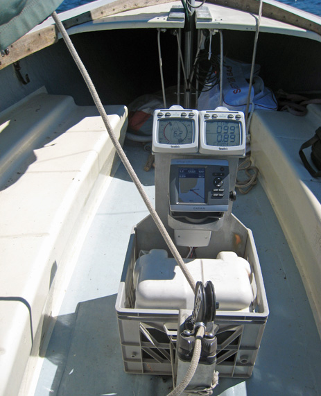
I don’t think I’ll be offered a job in any department at Lyman-Morse, but check out how I turned a milk crate and some wood scraps into Annie G’s new electronics test station. On top are the Tacktick displays already discussed, then there’s the wee Garmin 430, and the secret sauce — hard to see — is a Tacktick T122 NMEA Interface.
It was relatively easy to wire the Garmin’s NMEA 0183 output and one of its 0183 inputs to the interface (more on that later), and the results are grand. As you can see in this closeup below, bigger here, the dual line Tacktick is showing COG and BTW (Bearing To Waypoint, including some of the waypoint name) from the Garmin, and the plotter is showing wind info from the wireless Micronet sensors. There are lots of ways this could be useful, like getting more chart display by putting desired numeric data on the Tacktick. Note also that on the bigger new Garmins the wind can also be shown, or only shown, as a rose around the boat icon.
Note too the slight differences in the numbers, which in the case of BTW (143 degrees vs 144) probably has to do with the 0183 data rate. But in the case of wind speed (5.2 knots vs 5.4), I’m pretty sure it’s because I asked both systems to show “True Wind”, and each does it differently. Tacktick uses Speed through the Water to correct Apparent Wind Speed and Direction, which is what most sailors are looking for and sometimes called True Wind relative to boat. But I think the Garmin uses COG and SOG to correct the Apparent Wind it’s getting from Tacktick, the normal style of GPS plotters that might accurately be called True Wind relative to earth. Some systems that can deliver both, like the Raymarine E-Series, call the latter Ground Wind. At any rate, I took this whole rig sailing in sometimes light air last evening, and it was good.


What I want to know is how to you get your boat to point that close to the wind?
Russ … with a wind VMG = 0.0, my guess is this picture was taken while on the mooring.
Ben, if your trying to impress us sailors by featuring your Rhodes, you are succeeding !!
In regards to this setup, this is the most impressive I have seen on a Rhodes 19 .. not all of which I have sailed in the past had a working compass, and certainly none had a 12 volt battery or sensor/display to provide depth. This looks positively heavenly for such a boat.
… of course, I hope the milk crate is bolted down, as the mainsheet can easily snag it on a jibe.
All pun aside, this was a joy to view these pictures and read about the tack tick products.
Remember to keep your head out of the boat Ben!
Because Annie G. doesn’t have radar or AIS yet, Eli?
Ben, I have a Schock Harbor 25 arriving in the spring and I will install the complement of TackTick instruments [T205 package] along with the wireless nmea interface. The primary decision at this point is the gps/computer setup to go with and the choice is between laptop/VNS/usb gps nmea in and back out to TackTick or to go with a Garmin setup similar to what you discuss. Any thoughts on the tradeoffs there and what of the current Garmin line you would suggest?
This will be a daysailor and weekly club racer with an occasional weekend cruise. Thank you, Brian S
What a wonderful boat! Your choice of instruments is very thoughtful, and suggests a theme of elegant simplicity. Following that theme, I would urge you to go with a garmin 545, for a number of reasons: simple wiring, low electrical demand, great cockpit readability and ruggedness, none of which would apply to a laptop solution.
bstronger,
Congrats, beautiful boat, amazing what they are doing below deck with just 21.5 feet DWL. Your new boat will be well complimented by your selection of TackTick instruments.
But … a laptop or chartplotter … that seems like overkill. My thoughts:
1. Forget the PC, it’s really not workable in a confined space unless it has a touch screen $$$.
2. Rather than a chartplotter, why not a handheld garmin, and optionally consider a fixed mount for it to slide into. The power consumption is very low (30+ hours on a couple of AA batteries) and the Garmin product is superb at anything you need for a daysail or overnight. Besides, it’s cheap to get two of them so you have a backup. I am partial towards the color version, and if you choose not to use a fix mount, get a version with the built in compass.
3. If you still want to go for a chartplotter, make it really worth while by getting an integrated sat weather service. The Garmin GPS430sx, pictured in Ben’s posting above, is shown on the garmin site as the least expensive model supporting XM weather. With the weather service you can go out more often when the weather forecast is vague (e.g. scattered t-storms in the afternoon) and be able to assure your crew your keeping safety in mind with a near real-time picture of storms before they arrive in your area. This is really a big help to calm crew that would otherwise be worried about going out for a late afternoon race. It is also helpful when there is no wind, or it is raining, to determine when conditions will turn favorable … in that you can use this knowledge to salvage a daysail you might otherwise abandon. E.g. All in all, it makes installing a charplotter over a hand held GPS really worthwhile if your going to take that step.
Enjoy
Thank you for the input regarding my Tacktick to GPS aboard H25 setup. I actually have a Garmin 545S from my powerboat so I will also use it on the H25.
I do wonder about the actual connections. The Garmin diagram refers to RXD+ and RXD- and the T122 refers to GPS: NMEA 1 + and – and PWR + and -. But in addition there are seperate ALARM [nmea out/in] and PWR connections. Any ideas on how to wire this?
I would like to bench test it now so come spring I’m set to go.
That’s pretty easy, but take’s a few minutes to lookup some stuff. Fax me the relevant pages (or web site I can find the manual) and your contact info to 5.7a6b8c0d0e8, in the *5*1*6 area code. (hopefully disguised my fax # from robots)
Ben:
I wonder how much time you have spent with your Tacktick instruments. I installed a full compliment on my Catalina 42, raced and cruised 1500 miles, and concluded that they were terrible. After some time I found the US service people who told me that every single instrument needed its software updated to the 2008 software. Since then I have seen many negative comments about this equipment and in particular the total lack of customer service from Tacktick
Ben Ellison,(or anybody)
I have the very same Garmin chartplotter,and Tacktick instruments. I also have the Tacktick T122 NMEA Inferface. Could you tell me the wires (color) and locations in the Interface for your wiring inputs and outputs.
I surely don’t recall the wire colors but Raymarine is still selling all the TackTick gear including the Wireless NMEA Interface and the manuals are here
http://www.raymarine.com/view/?id=1237
Just remember that NMEA 0183 output, also called “tx” or “+”, goes to Input or “rx” or “-”
And here’s some more on what I did with the gear:
https://panbo.com/archives/2009/06/wireless_n2k_wind_more_tacktick_style.html
I cant for the life of me get my tacktick interface to talk and listen to my Garmin Chartplotter. The Garmin is Blue out and Brown in where do I hook up to the Tacktick and does the ground have to go anywhere special?
Please help….
George, every NMEA 0183 one way connection requires two wires, though sometimes they use a common ground wire. So getting a two way data connection between your Tacktick box and Garmin is going to require 4 data terminals on the Tacktick and 3 or 4 wires on the Garmin (they vary by model). You’ll need to have both manuals, but once you get the needed connections sorted out, this should work fine. (You may also have to change NMEA 0183 settings on the Garmin.)
All TackTick manuals are now at Raymarine:
http://www.raymarine.com/view/?id=1218
PS Some good primers on NMEA 0183 here:
http://continuouswave.com/whaler/reference/guideNMEA0183.html
http://www.boat-project.com/tutorials/nmea0183xcon.htm
http://boatprojects.blogspot.com/2012/12/beginners-guide-to-nmea-2000-nmea-0183.html
Ben, when you say “It was relatively easy to wire the Garmin’s NMEA 0183 output and one of its 0183 inputs to the interface (more on that later)” – I’m keen to read the “more on that” bit! Please can you provide details. Many thanks
That was 13 years ago, Rich! (And sorry to all for all the times I’ve written “more on that later” and then never did.)
But I vaguely recall that this install was when I learned more about the annoying complications of NMEA 0183 interfacing. It worked fine, but that Garmin to Tacktick connection was what is called (at least sometimes) “Single Ended to Diffential.” You’ll see it explained and illustrated toward the end of this pretty good explainer (written at about the same time):
http://boatprojects.blogspot.com/2012/12/beginners-guide-to-nmea-2000-nmea-0183.html