
Pilot’s bag, part 1
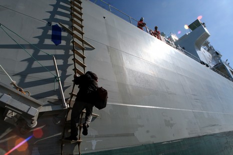
That’s Skip Strong making his way down Nor’easter’s twisty pilot ladder, as seen from the bow of the Penobscot Pilot. Man, that move must get the adrenaline pumping, say, on a dark night with a big sea running. (Capt. Ryan told me that they can manage a ladder like this in up to about eight footers, sometimes getting the ship to turn toward the ladder and using the flatter turbulence created inside the turn). At any rate, Strong, who is a bit of a geek (and I mean that in a good way) has quite the electronics in that bag he’s toting.
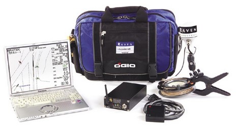
Below you’re looking at a Raven Portable Pilot System. At right is a mini GPS/differential beacon combo antenna (nicely accessorized with clamp and cable organizer). It attaches to the middle box, which contains a sub-meter dGPS and a WiFi transmitter. The small box is a wireless pilot Interface that gets attached to the pilot port of the ship’s Class A AIS. Those of you who’ve hassled with yacht interfaces may appreciate that these pilot ports are notoriously flaky. In fact Raven’s box is equipped with a switch that will reverse data flow, and Skip carries a special patch cable that will ‘fix’ another common wire mix-up (more on that story here).
Once set up, a background application on the little laptop collects all this information (and private Raven-formatted boat info off the Internet if desired), and can then both record it and deliver it to charting applications like Nobeltec Admiral and Capn Voyager (which, by the by, Maptech now packages with a ship load of data). Mostly, though, the hardware is used to feed Wheelhouse II, an interesting pilot-specific program we’ll look at in part 2.


")


I suggest that the pilots dump the big bag of junk. Here in Singapore the pilots use a Pocket PC and a Bluetooth transmitter. On the Pocket PC we use Navpak Pilot Pocket program with ENC charts. The bluetooth transmitter is made by serialio.com. We connect it to the AIS with a Pilot cable. The cable connects to the Pilot port on one end and the Bluetooth transmitter on the other end. The cable has a small inline switchbox as a descrambler. Everything fits in the pockets without the big bag and makes it easier to climb the ladder.
Jenia.
Some of these vessels are huge… what IS the position which their plotters use? The antenna location at the bridge would be way aft.. no?
How do they compute turns and entering channels? Can anyone give a quickie lesson here?
Most serious plotting software can use the position of the GPS antenna relative to the vessel’s dimensions and then plot your vessel to scale when you’re zoomed in enough. It’s the same with AIS. In both cases true heading (not COG) and rate of turn refine things. A problem, seen too much in AIS, is that poor math and/or difficult interfaces sometimes leads to wacky overall dimensions.
Skip, stick with the, “Bag of Junk.” The Singapore solution has no autonomous DGPS. I know I’m preaching to the choir. Piloting, as always, is local. Probably works fine for them.