
AIS target received, goal achieved
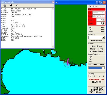
I felt like a spy in an old WWII movie, rigging a VHF antenna and GPS on the patio outside my hotel room late at night, then hunching over my laptop hoping for certain transmissions…but, by golly, it worked. The Si-Tex/Nasa receiver heard an AIS equipped 37m vessel called Ixplorer apparently anchored or docked 3.7 miles away in La Ciotat. There was only that one target (the Radio Shack antenna was missing a set screw, which probably affected range), plus I didn’t have a detailed electronic chart of the area, but it worked. That’s the target info showing above in SeaClearII, the freeware that comes with the receiver. SeaClear was pretty easy to set up with both USB GPS and AIS serial input. I also tried the gear with Coastal Explorer 1.1, again easy to set up, but also capable of calculating CPA/TCPA (and displaying more target info, and in a couple of different ways). I’ll try the rig some more when I’m in Naples tomorrow and later in Ft. Lauderdale, assuming my luggage gets there.
PS. Totally different subject, but was somewhat saddened to learn on Zephyr that Pride of Baltimore II (a remarkable boat I’ve had the pleasure of twice passaging aboard) lost her entire rig off France last month. The good news, and hard to imagine how, is that no one was hurt. More good news, for those interested, is that two crew members are blogging the mishap and repairs.


Dear Panbo,
My project is based on the following to find a simple but effective tracking system that can track mining trucks and light vehicles when they pass though/by certain delegated check point/waypoint/geofences/zones. This particular project is based on the following criteria;
The project/s at hand, require the following to be tracked, documented And data collected and tabulated in required form. Please see the parameters as below;
1. The terrain is a remote Coal mine in Kalimantan, Indonesia (more than
5 mine sites)with the main site as trial site.
2. The customer requires their Coal Haulers/trucks (as per attached Specification drawing)to be tracked up and down a 14 km Haulage track/dirt road.(very rugged and hot and no communications apart from internet)
3. The coal Haulers/trucks must be tracked at/across 4 check/way Points for Time to/at/across and duration between these 4 check points for each Hauler/truck name/number (and possibly other data if can be accessed and recorded. (basic haul road/track map attached with 4 designated check points for and example). The trucks must be time stamped going up and back down the road at each of the 4 check points.
4. The hauler track/road is from 30 to 60+ meters wide and 14km long
5. The haul trucks could be on any part across the haul track/road width when passing a check/weigh point.
6. The first project (coal mine) has 30 + heavy Coal Hauling Trucks to Track. The haul trucks do an average of 18-20 hauls per 24 hour period each. Which is 18-20 return trips from the Pit to (14km)loading area
7. Data must be reasonably accurate.
8. If using RFID tracking then we must be able to use very low power requirement for each check point because we would have to use Battery and/or solar power at each check point.
9. We can network each check point back to a main server at the site office 14 Km away by 2.4Ghz Wireless Access Point Network if required.
10. Please list what equipment etc is required on our end for this type of configuration and installation for the above conditions.
11. Please list your supply equipment/solution specifications and what It can do and what is required as per above conditions and specifications.
12. List your products that we are required to purchase for the project above and include prices for each.
This is one project that we would like to design and quote our customer As soon as possible. We have many other projects to this type that require the tracking and data collection of both heavy and light vehicles and assets on mine sites if this one is successful and we learn how to adapt your products to our market for the many solutions required then we will be able to do a lot of business in the very near future. There are 5 such mine site for this one company alone and there are more than 10 main size sites to the likes of this with some of them operating more than 350 Coal haulers and 1000 light Vehicles and over 5000 personnel. They may even like to start tracking personnel in the near future.
The above was based on a proposed RFID Tag and track technology but in that case we would have to install Solar powered RFID long range readers which would prove to be a handful to maintain and also is quite expensive and if the track direction was to change they would have to dig up all the foundations etc and move it to the new position.
However i have an idea to do it with the AIS system over GPS and VHF. It could all be done from one Base station location at the host site office. I know of one company using the AIS in Australia for a similar system but is very expensive. After I have researched all of the AIS equipment I factored it would cost around US$800 +/- to fit out each truck and then for the base station would be around US$2,000 + server etc.
The main point here is to track every one of the 30 trucks up and down the coal track and time stamp the at the 4 proposed designated check points. The sort and calculate the data for each truck for to each and duration between each check point. That�s the objective. They just want o keep track of the data so if there is a problem with count the coal trucks one day or the amount of loads go below normal for some reason or some drivers are not doing their job or other they can simply pull out the data go to that truck report and check it all out and make reports from it etc.
I am a bit lost never having used the AIS and VHF so your assistance in this type of project would be great. Let me know what you think on this. The tracking software using the Coastal Explorer would be great and would just have to import in a local land map correct?
Could you assist me in my endevour to see if this crazy idea of mine will work by using your AIS syatem and software for tracking Vehicles.
I look forward to your reply
With best regards
Dean Reardon
WISP Broadband and IT Solutions
http://www.SatNetCom.com
Ph: + 62 – 542 – 875570
Fax: + 62 – 542 – 876302
Mobile: + 62 – 542 – 7030512
e-mail; [email protected]
“Connecting the World”
Dear Sir,
About Searclear Sofware, I think it have some problems:
– No display IMO info;
– Target display is slowly;
– Can’t reconnect when use TCP/IP port;
– Long time no update or repair software;
Thanks
Hung