
AIS plotting, NavSim style
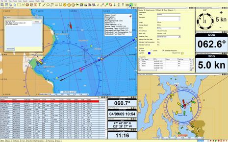
At the Miami Boat Show, NavSim Technology was showing some neat AIS plotting features, and yesterday I got them to send some illustrative screen shots. In the lower right “secondary chart view” above you can see how NavSim uses yellow, green, and red target icons to show moored, moving, and dangerous vessels (a full explanation of AIS icons here, and special Class B icons are coming soon). You can also see how a user can set an AIS Filter Range, which doesn’t actually eliminate any targets but does reduce them to dots (sort of like IMO “sleeping” and “active” targets). In the main chart window, you can see what happens if a target’s CPA and TCPA violate user set minimums; the Alert pops up along with red and purple “ghost” icons depicting the target and your vessel in the worse case scenario (i.e. at the Time of Closest Point of Approach). And there’s more…
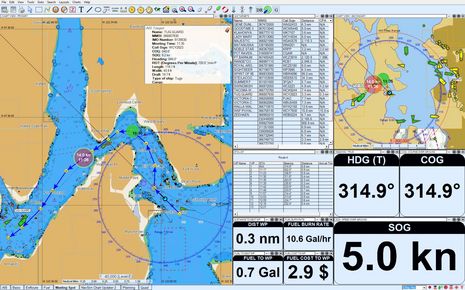
When AIS targets are not transmitting their positions frequently, NavSim dead reckons them with a green frame icon, as you can see below for the vessel Ernest Campbell. I think this could be very helpful with Class B targets that only transmit every 30 seconds, at best, though of course the user has to understand that the DR ‘ghost’ presumes that the target maintains course and speed. Since this screen was taken using NavCruiser Pro, it also illustrates the “meeting” feature. If your vessel is on an active route and you click on another vessel near that route, NavSim will calculate where and when the other guy will pass or overtake you (the green circle below).
 Moreover, if click grab that meeting spot and move it along the route, NavCruiser Pro will calculate the leg or overall speed change (you decide) needed to achieve the desired new meeting point (the red circle below). I think that similar features are also in Jeppesen ECS (now called Workboat Navigator) and Rose Point ECS, and maybe others, and they all suggest how sophisticated AIS plotting can get. NavSim, by the way, also has a neat Tacking Time to Destination feature in its SailCruiser edition, which can even suggest windward routes (screen shot here).


I saw this company’s display at the Toronto Boat Show in January, and when I had a fairly arcane question, the woman in charge phoned Montreal to get a clarification…from her father, the guy who owns the business and wrote in part the program!
I was impressed by the flexibility and range of the Sail Cruiser product and will follow them with interest as the time approaches for making these decisions.
These programs show how much power there is in a personal computer and what can be done with multiple inputs from position devices, and transducers. We will soon be drowning in data, options, choices and preferences unless these designers create good user interfaces. From first glance this company seems to be doing a pretty good job. It looks very interesting.
St John’s Newfoundland – home to NavSim and some of my relatives. By the way, NavSim has fuel useage up to 200 gal per hour in case you have a large “Gizmo”!
-Doug
I tried many programs, but this one was best and in my budget. Very well programmed and user friendly.
Jaak, Estonia
http://puhastuul.blogspot.com/