
NavSim, new products for sailors and pros
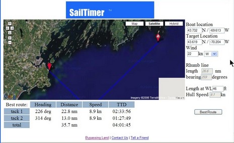
It’s hard to make out until you view the bigger image, but this screen is a Google Map demo of an interesting utility that can guesstimate an ETA for a boat that’s tacking into the wind. It was originally developed as SailTimer, but is now going to be incorporated into a new SailBoat Edition of NavSim’s BoatCruiser. I think that full-on routing modules, like RayTech’s and MaxSea’s, can provide this same sort of real life ETA, based on weather forecasting and a boat’s performance data, but maybe I’m confused?
Starting yesterday at the WorkBoat Show in New Orleans, NavSim is also previewing a new version of NavCruiser Pro that uses C-Map Max Pro charts. Prior to this product, the Pro format—which looked very powerful in a presentation I attended at the NMEA conference—was only available on the Northstar 8000i, a system I gushed about last year, but is only now coming to market (there were some problems). At any rate, I flew down to New Orleans today, mostly for a Charles Industries product introduction, but plan to visit the Show tomorrow (anything particular I should check out?). Which is why there’ll likely be no Panbo on Friday, but I may get to see NavSim’s latest.


Hi Ben,
Just a quick note to clear up some the MAXPro issue.
MAXPro was on display on at least 2 other systems at METS apart from the northstar 8000i
TMQ C-Plot MAXPro from Australia and Chartworks THE MAP MAXPro
We have been importing C-Plot MAXPro into the UK since June and selling since then. C-Map know about but seem to only recignise northstar.
A C-Plot box was on the C-Map stand at METS 2006
In response to Ben’s question about SailTimer versus the high-end tactical weather routing programs…. With SailTimer you don’t have 50 different variables to fiddle with. At a glance, you can see the optimal tacking route overlaid on a chart or aerial photo. Getting this simple display and your Tacking Time to Destination (TTD) should just be a basic aspect of sailing the boat. SailTimer makes it easy.
The screenshot posted is actually from SailTimer for Google Maps. That is a handy way to test out the program. You can plot a route on an aerial photo of your favorite sailing area. Google Maps do not even require any download — just go to http://www.TheOriginalSailTimer.com . However, Google Maps only work with an internet connection, and do not show water depths. For those capabilities, and if you want to compare TTD for alternate routes, or enter custom polar data for your own boat’s speed characteristics on different points of sail, you need the chartplotter version.
BoatCruiser – Sailboat Edition will be officially launched at the Toronto Boat Show next month (January 2007).
SailTimer is being integrated into MacENC, but we plan to take it one step further by supporting user supplied polars (performance plots) for the users boat. This will allow SailTimer to provide the optimum heading to sail before and during the trip. Wind Speed and Angle will come either from user entered values or connected NMEA wind instruments.
The recommended course to steer will be overlaid on the chart and the ETA to the next course change will be provided.
We believe this will be a great addition to the already powerful MacENC. MacENC retails for US$99.95
http://www.macenc.com