
Navman introduces NavPix, photographic waypoints
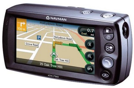
I don’t normally get into car navigation but this is an interesting idea, and it’s from a company that’s very much in Panbo’s radar. The Navman ICN750 above has a built-in camera meant not for snapshots but for easily shooting geopositioned photographs—dubbed NavPix—that you can later page through and select as go-to waypoints. Associated PC software and a NavPix Web site will even let you share such image waypoints with family, or the world. The press release quotes Navman USA general manager Chris Jensen thusly, “We tend to remember images better than we remember addresses. We all know what the Washington Monument looks like, but do we know the actual address? Most of us have commented to a driver at least once in our lives, ‘I’ll know it when I see it!’ Navman, NavPix technology and the global NavPix community set the new standard for navigation simplicity.”
Would this idea apply to marine plotters, where the ‘addresses’ are even harder to remember latitude/longitude numbers? Hell yes. In fact, I think boaters will eventually get all sorts of benefits from the fierce competition for the potentially humongous automobile navigation market. However, that same fierce competition is why it makes some sense for Brunswick to sell off the land navigation portion of Navman; it is not, as they say, a ‘core’ business. But why is Brunswick also selling off Navman’s marine division, already separated into Brunswick New Technologies Marine Electronics (BNTME) along with Northstar and MX Marine? I have heard a lot of rumors and speculation in the last week, but no one really seems to know. Tomorrow I get to chat with David Ritblatt, president of BNTME, and that should be interesting!


Very interesting idea. The challenging part would seem to be where to put the waypoint. Is it the thing you are seeing, or the point from which you take the photo? Or maybe just getting close is all that matters.
I’ve been doing essentially the same thing for several years … a technique I call ‘Image Logs’. It was published by Ocean Navigator in Issue #144 and can be read at http://yachtvalhalla.net/articles/imagelogs/imagelogs.htm
Terry
With the cost of GPS dropping in cost one wonders when the coast guard might install smart buoys which send their position and even some data much like AIS. This would be the next evolution of the racon. What say you?
I also like the idea with charts where the nav aids appear on the chart as they do at sea with the characterists and range and so on showing graphically on the chart
The remember the location deal for navigation is really applicable when there are land features and you are doing “close in” coast work. Admittedly light houses can tend to look alike… but I don’t think the idea of getting to some point by scanning picyures of light houses really makes sense.
There should be ways to activate chart features and have them appear as paper facsmiles all the way to complete meta reality with images and text… depending on what you want to see when. This would mean a stepped de clutter feature… and probably a vector based system.
I do see some benefits from a cruising persepctive to having images embedded in charts so charts become like more interactive cruising guides. In fact, I would love it, if say the Chris Doyle cruising guides were integrated into chart software and you could mouse over to an icon and read the text of see some of his images and graphics.
Jef
sv Shiva
Contest 36s
With regard to the idea of “Smart Bouys”, I thought this was already being done via AIS technology.
If one visits the AIS Liverpool web site, there are a number of navigational marks that are showing up on the AIS display, some are bouys; some are land based. For example, the Fairway mark in Belfast Lough is shown this way.