
Garmin GPSMap 9000 series, high resolution and big power
Garmin’s GPSMap 9000 series is a tour de force in many ways. At 27 inches, the largest member of the line is the largest main stream MFD out there. With 4K resolution it’s the highest resolution MFD on the market. It has ample processing power, myriad interfaces for integration, and ample screen real estate.
At first glance, 9000 series MFDs look an awful lot like the 8400 and 8600 series units they succeed. But, a deeper look reveals a lot changes and improvements in the new chart plotters. Garmin introduced the first of the 8000 series more than ten years and continues to offer it today. It stands to reason that Garmin designed the 9000 series to last another decade or longer. With processors seven times as fast, displays with almost four times the pixels, and network interfaces capable of ten times the speed compared to their predecessors, the 9000s have a lot of headroom.
In my experience, each brand of chart plotter has various strengths and weaknesses. Garmin 8400/8600s, even with hardware introduced seven to ten years ago, have never felt sluggish or underpowered. Driving the higher resolution display will consume more processing power, but I suspect a lot of the increased power in these new displays goes to guarantee Garmin can continue to deliver a positive user experience, even after currently uncontemplated features are added.
Like the larger screen 8400 and 8600 models they replace, the 9000 and 9200s are premium products and they’re priced like it. The least expensive option in the line is the 19 inch GPSMap 9019 at $9,900. The only difference between a 90xx and a 92xx model is the latter includes Garmin Navionics+ cartography while the former only includes a worldwide basemap. Stepping up to the 92xx with bundled cartography adds $100 to each model. The 22 inch 9022 and 9222 models are $11,400 and $11,500. Moving up two inches to the 24-inch 9024 and 9224 brings the cost to $13,400 and $13,500 respectively. Lastly, the 9027 and 9227 are the largest members of the lineup — and largest integrated chart plotters or MFDs in recreational marine –will set you back $16,900 and $17,000 respectively.
All GPSMap 9000 series models include a GPS 24xd GPS receiver and a NMEA 2000 starter kit. Similar to the larger models in the 8400/8600 line, these chart plotters don’t have a built-in GNSS, hence the bundled receiver. Additionally, all models in the 9000 series use Garmin’s tri-fold, magnetically secured sun cover.
The differences
The basic look of the 9000 series is very familiar. The all glass touchscreen front is back. Additionally, the MicroSD card slots remain around back. Bezel sizes appear about the same as the 8400/8600s. I did notice two physical changes. First — and highly welcome — is the move from plastic trim pieces at the top and bottom of the display. These pieces cover the screws and give the unit a nice finished look. The 8000s used plastic trim and while it worked fine, after spending some time in the sun, they tend to become brittle and are easy to crack if you have to remove them. The second change is a move to stronger magnets in the sun covers. The cover has stayed in place nicely and not slid at all.
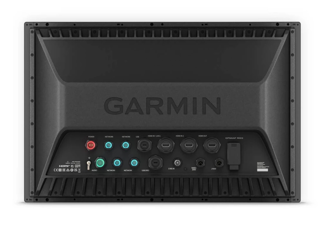
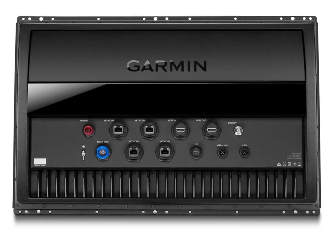
Around back, there are several other differences to discuss. First and foremost has to be the move to gigabit Ethernet. Garmin calls their proprietary connector system BlueNet and finishes off the compact connections in a sporty shade of blue. You may well have seen these connectors before as Garmin has been fitting them on recent radar units, cameras, and other Ethernet equipped components. But, until the release of the 9000s, they hadn’t used the bright blue coloring so as to avoid calling attention to them.
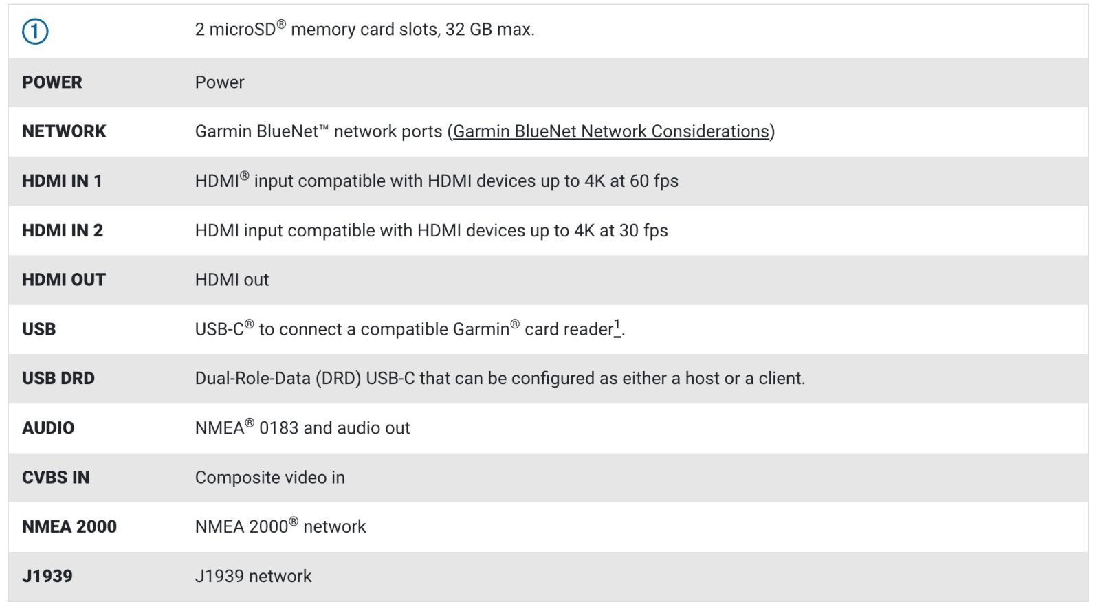
The 9000s sport a second HDMI input. With the large screen sizes and 4k resolution, it seems likely some of the plotters will see service as displays for other video sources including streaming players. Plus with HDCP compliant encoding, Garmin says you can share content from one 9000 with others on the network. I struggled enough to get one 9219 on Panbo(at), so it’s safe to say I wasn’t able to test this. Since the 8400/8600, Garmin has included stereo audio outputs in the NMEA 0183/audio connector. Garmin has trimmed the 9000 series 0183 connectivity compared to the previous models. While the previous generation has four NMEA 0183 inputs and two outputs, the 9000s only have one input and one output.
USB connectivity expands with a dedicated USB port for external card reader — a useful accessory if the rear of the unit will be difficult to access — and a dual role port that works in host and client modes. The rest of the connectivity looks similar to the 8400/8600s. It is nice to see that the composite video input sticks around and is still encoded to the network so it can be shared with other displays.
Small boat, large display

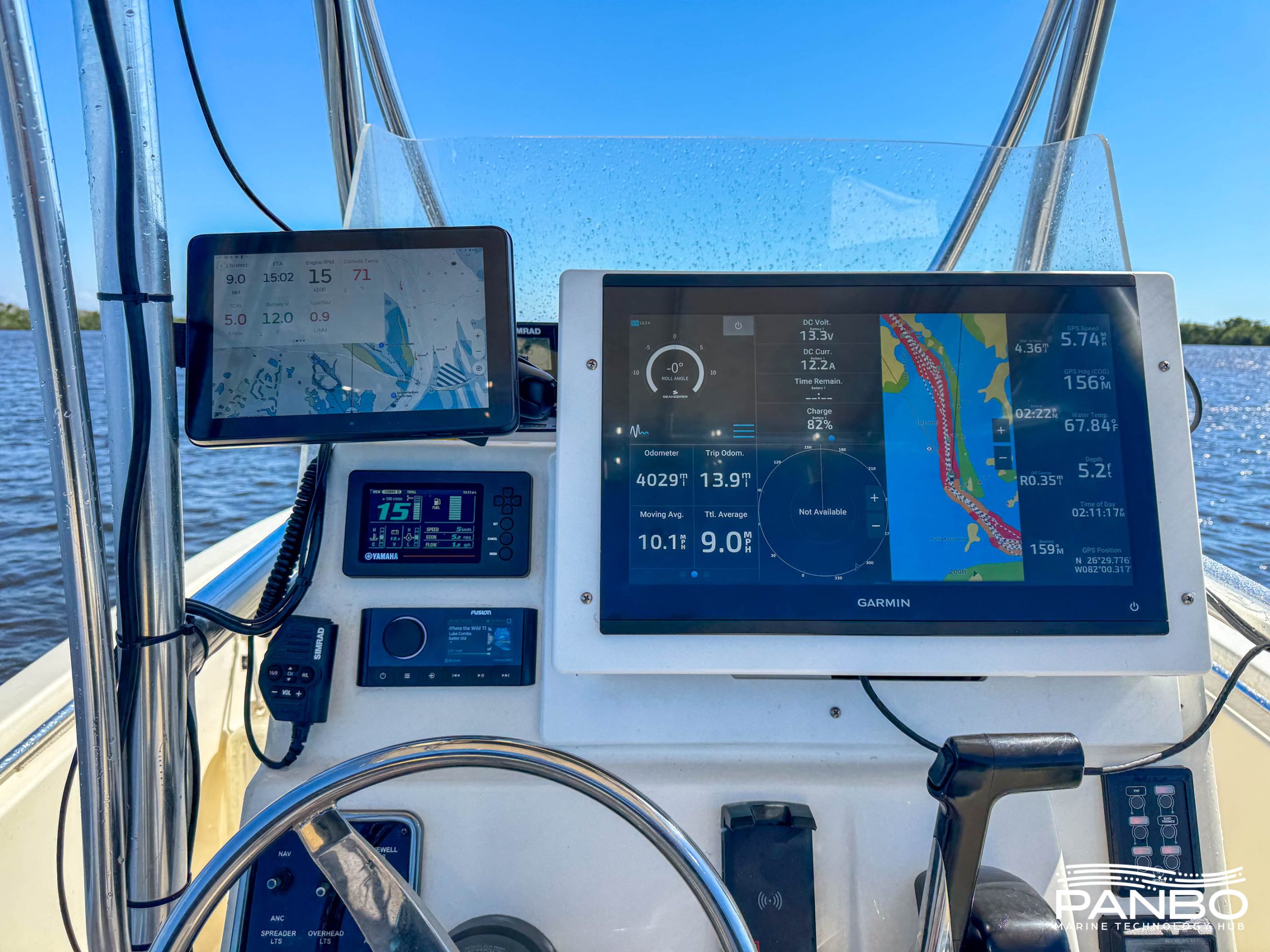
I don’t imagine that Garmin figured too many 22-foot center consoles would be refit with any of the launch sizes — 19, 22, 24, and 27-inch diagonal screens — of the 9000 series. But, I’m currently short a larger test platform so, Panbo(at) is my only option. Unfortunately, my 9219 is taller than the Cobia 220cc’s dashboard. It took a little creativity and time with my CNC router to build a workable mount.
I’m pleased to have the 9219 securely mounted at the helm. Unfortunately, if you’re under about 5-foot 8-inches (like my wife and daughters) it’s nearly impossible to see over the plotter without a stool. Hence, I don’t expect the 9219 will be a permanent fixture on the boat. Although, the longer the 9219 is on Panbo(at) the more I’ve adjusted to the luxury of this large, high resolution plotter.
Using the GPSMap 9000
If you’ve used a recent Garmin GPSMap series MFD, including the x2, x3, 8400, or 8600 series, the user interface on the GPSMap 9000s will be pretty familiar. A few years ago, Garmin refreshed the UI. Changes included a freshing of the overall look and moving home functions to the lower third of the screen rather than a dedicated home screen. Otherwise, beyond some polishing of the experience, the interface has been very consistent for quite a while.
My time using the 9219 lead to three major conclusions. They are: first, this plotter is seriously fast, second, the screen is bright and extremely crips, and third, a 19-inch display mounted this close is big!
One of the realities of a higher resolution display is that it puts a greater load on the processor to drive it effectively. It seems Garmin added plenty of horsepower to ensure the additional load doesn’t impact the user experience. Even when flinging around a chart, the unit responds crisply and seemingly effortlessly.
The 4k display means there are tons of pixels to work with and they’re plenty bright. I’ve done most of my testing in full Florida sunshine. I’ve noticed that even in direct sunlight, the backlight is often not at 100 percent.
For the most part, the screen size is a plus. I’ll talk in a moment about how I’ve used all that screen real estate. Unlike on Have Another Day and other larger boat helms, I stand directly in front of the plotter. In single function windows, the display is just about larger than I can take in. I know, first world problems to say the least. I also think that’s a factor of a large display mounted on a small boat and likely not Garmin’s intent.
Useful splits
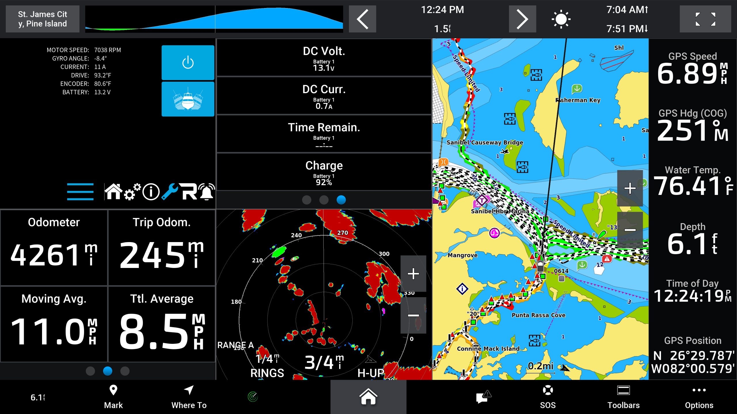
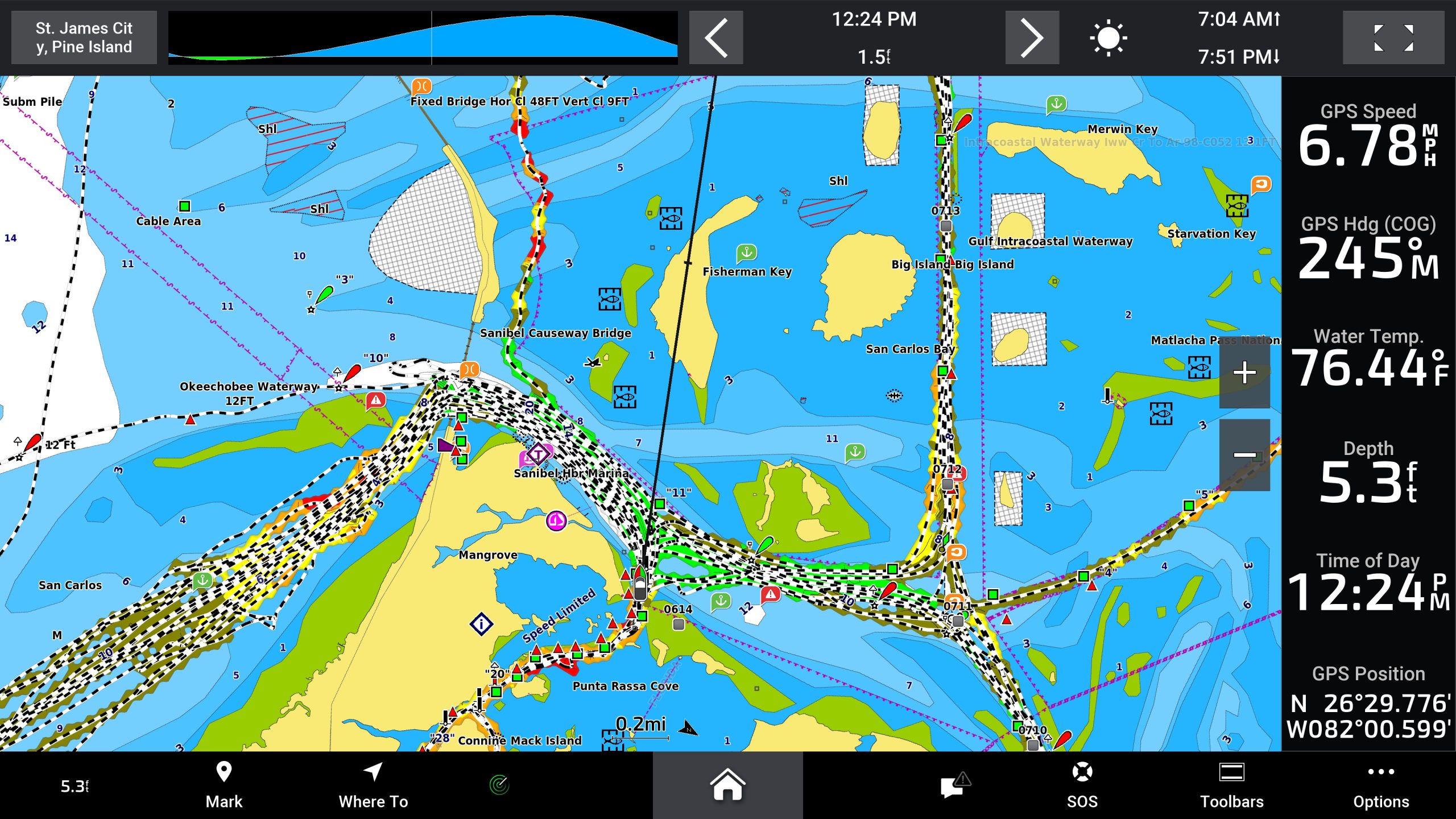
There is nothing new about split screen layouts on chartplotters and MFDs. But, there is something new about useful splits with the screen split, two, three, four, five, or even more ways. The venerable Raymarine Pathfinder series equipment supported top and bottom splits and did so quite effectively. But, if you’ve ever tried to split the screen more than two ways on most plotters, you may have been disappointed. Previous to the 9219 I’m testing, I’ve preferred multiple smaller displays rather than one large one. The difference with the 9000 series is that each of the splits is actually useful.
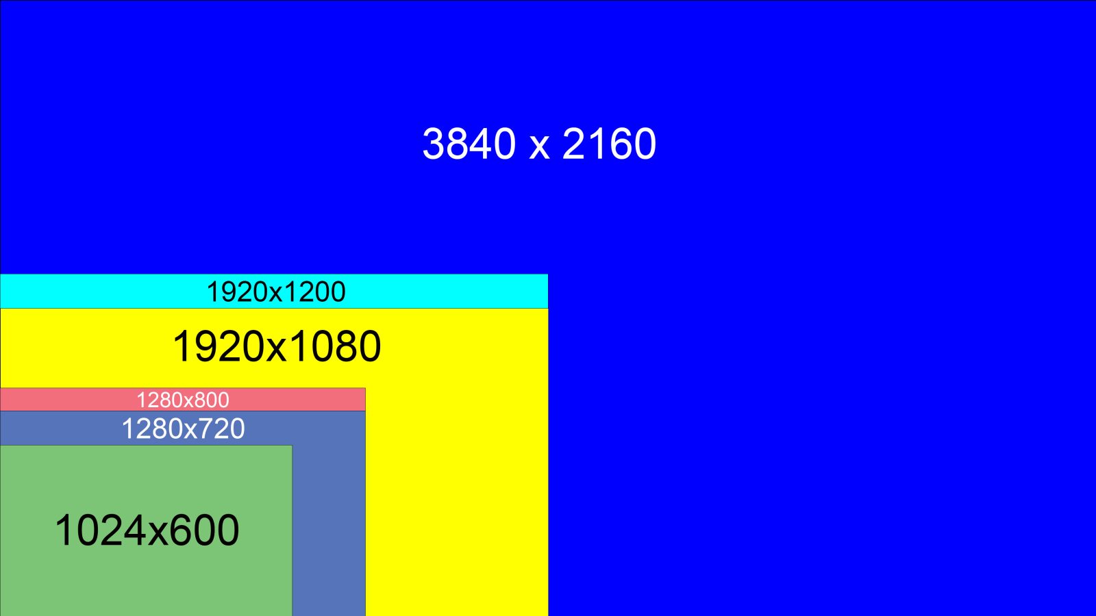
Most of that comes down to resolution. Hopefully the image above helps to illustrate the extreme difference in the number of pixels available to render a display. At the lowest resolution, we have 1024×600 or 614,400 pixels. Compare that to the 8,294,400 pixels available from the 9000’s 3840×2160 displays. That’s fully 13.5 times the available pixels.
| Model | Screen size | Resolution |
| Furuno NavNet TZTouchXL 10 | 10-inch | 1920×1080 |
| Furuno NavNet TZTouchXL 13 | 13-inch | 1920×1080 |
| Furuno NavNet TZTouchXL 16 | 16-inch | 1920×1080 |
| Furuno NavNet TZTouchXL 22 | 22-inch | 1920×1080 |
| Furuno NavNet TZTouchXL 24 | 24-inch | 1920×1080 |
| Garmin GPSMap 743 | 7-inch | 1024×600 |
| Garmin GPSMap 943 | 9-inch | 1280×720 |
| Garmin GPSMap 1243 | 12-inch | 1280×800 |
| Garmin GPSMap 1643 | 16-inch | 1920×1080 |
| Garmin GPSMap 8410/8610 | 10-inch | 1920×1200 |
| Garmin GPSMap 8412/8612 | 12-inch | 1920×1080 |
| Garmin GPSMap 8416/8616 | 16-inch | 1920×1080 |
| Garmin GPSMap 8417/8617 | 17-inch | 1920×1200 |
| Garmin GPSMap 8422/8622 | 22-inch | 1920×1080 |
| Garmin GPSMap 8424/8624 | 24-inch | 1920×1200 |
| Garmin GPSMap 9019/9219 | 19-inch | 3840×2160 |
| Garmin GPSMap 9022/9222 | 22-inch | 3840×2160 |
| Garmin GPSMap 9024/9224 | 24-inch | 3840×2160 |
| Garmin GPSMap 9027/9227 | 27-inch | 3840×2160 |
| Raymarine Axiom+ 7 | 7-inch | 1024×600 |
| Raymarine Axiom+ 9 / Axiom 2 Pro 9 | 9-inch | 1280×720 |
| Raymarine Axiom+ 12 / Axiom 2 Pro 12 | 12-inch | 1280×800 |
| Raymarine Axiom 2 Pro 16 / Axiom 2 XL 16 | 16-inch | 1920×1080 |
| Raymarine Axiom 2 XL 19 | 19-inch | 1920×1080 |
| Raymarine Axiom 2 XL 22 | 22-inch | 1920×1080 |
| Raymarine Axiom 2 XL 24 | 24-inch | 1920×1200 |
| Simrad NSX 7 | 7-inch | 1024×600 |
| Simrad NSX 9 | 9-inch | 1280×720 |
| Simrad NSX 12 | 12-inch | 1280×800 |
| Simrad NSX Ultrawide 12 | 12-inch | 1920×720 |
| Simrad NSX Ultrawide 15 | 15-inch | 1920×720 |
| Simrad NSS9 evo3S | 9-inch | 1280×720 |
| Simrad NSS12 evo3S | 12-inch | 1280×800 |
| Simrad NSS16 evo3S | 16-inch | 1920×1080 |
Currently, GPSMap 9000 and 9200 series displays are only available in 19, 22, 24, and 27-inch screen sizes. The large, high resolution displays mean that each split screen window is minimally the same and in most cases higher resolution than any other display available today. Additionally, a 9219 split into four views yields four 9.25-inch diagonal windows, a 9222 split four ways yields 10.72-inch windows, a 9224 yields 11.89-inch windows, and a 9227 gives you four 13.47-inch windows.
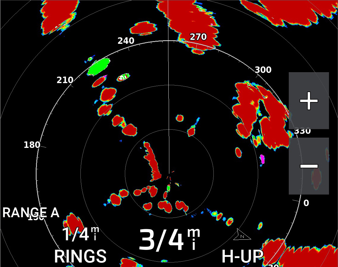
The image of a radar scope you see above is cut directly from the screenshot at the beginning of this section. You can also see the size of the radar scope in the photo at the top of this article. It’s not huge, at just over 6 inches measured diagonally. But in my use I’ve found the mix of acceptable size and high resolution makes even this small window useful. The screenshot this image came from had a total resolution of 3,840 x 2,160 pixels. Just this section is 1,126 x 890 pixels. That’s actually more resolution than any of the 7-inch chart plotters listed above!
BlueNet
BlueNet is bigger than just the GPSMap 9000 series. Going forward, BlueNet is the networking standard Garmin will use for high bandwidth communications between all of their marine products. At its most basic, BlueNet is gigabit Ethernet with Garmin’s own connector on it. The connector is about the size of a NMEA 2000 DeviceNet connector. Compared to Garmin’s previous RJ45 connector with a waterproof collar (called Garmin Marine Network or GMN), the new cabling is much easier to pull through crowded raceways and small diameter holes.
Garmin has been using this connector and cabling system for several years. To my eye, it just sort of appeared one day on a few devices like GC200 cameras and recent radar units. It turns out that although that may have looked a little haphazard, it wasn’t. Any device with the small connector has a BlueNet compatible interface builtin. That means those devices can connect directly to a BlueNet capable MFD.
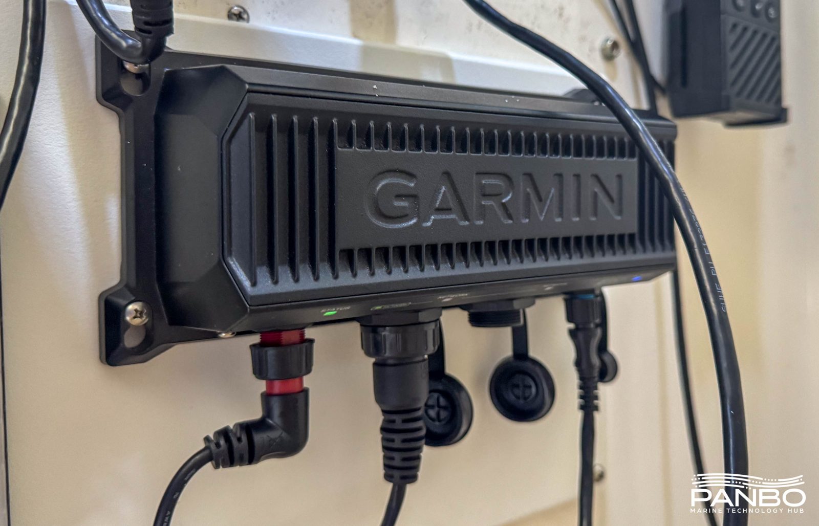
Garmin branded equipment with the older GMN, like MFDs, radars, etc, is compatible but requires the use of a BlueNet 30 Gateway to convert between GMN and BlueNet. Interestingly, third party equipment, including cameras and OneHelm devices, connect directly to the BlueNet side of the network. The gateway appears to only be needed when there is legacy Garmin equipment to be integrated.
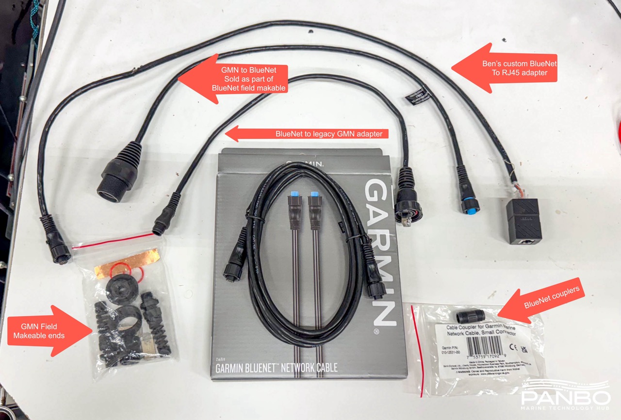
The smaller BlueNet connector doesn’t seem to have a field makeable connector option. To work around this, Garmin offers a field installable adapter kit consisting of two GMN field installable connectors and two GMN to BlueNet adapter cables. These parts can be seen on the bottom left and top center of the adapter photo above. At $50, it’s not cheap, but it will allow you to install two ends in the field.
If you’re like me, you probably have quite a few of the adapters going in the opposite direction from the one I just mentioned. These adapters convert from a BlueNet or small network connector to GMN. Devices that shipped with the BlueNet connector prior to the formal introduction of BlueNet included them. On installs where I had to cut cables anyways, I typically just put a GMN end on the BlueNet cable.
The BlueNet Coupler (bottom right of the adapters photo above) irks me a bit. It is $25 for this tiny little coupler. Compared to the cost of BlueNet cables and other components, it seems a bit excessive. I will admit to frequently getting grouchy about the cost of proprietary cables and none of these hold a candle to what engine manufacturers charge.
No OneNet?
Garmin announced the GPSMap 9000 and with it BlueNet just as the National Marine Electronics Association (NMEA) was finalizing the OneNet certification tool. At first, I thought the timing was interesting and perhaps a little unfortunate. But, after a little reflection I realized that the transition to BlueNet has been in the works for several years. OneNet has taken quite a while to come to its final state and hence it’s unlikely Garmin could afford to wait for OneNet to be ready to roll. That of course assumes that Garmin wants to be a OneNet trailblazer. I’ve long assumed that smaller specialty companies like Actisense, Digital Yacht, Maretron, and others will probably lead the way.
However, the move to BlueNet and the introduction of the BlueNet 30 Gateway may provide a roadmap for how OneNet could also be integrated into a Garmin network. With a OneNet gateway, Garmin would be free to integrate OneNet and meet the standard’s requirements, especially those around standard cables and connectors, without having to modify all their devices.
OneNet is just getting going so it will take time to see how the major manufacturers choose to adopt it. For now, I think they’re all taking a bit of a wait and see approach.
Future (smaller) models?
As soon as the new plotters were announced, I immediatley asked my contacts at Garmin what this means for the exisitng 8400/8600 series products and when we can expect to see smaller versions. The deep breath they took before responding suggested I wasn’t the first person to ask. The answer I received wasn’t very specific. It does seem clear we won’t see smaller 9000s in the near future. But, the more I’ve thought about it, the more I wonder how Garmin will refresh the smaller end of the 8400/8600 product line. Frankly, I’m not sure a 4k 9210 makes all that much sense. At that screen size, the pixel density would be impressive, but the utility perhaps questionable.
So, it seems that although the 8000 series is in its second decade, it probably isn’t going anywhere for a while. But, I wonder if we might see some refreshed models. Perhaps with slightly faster processors and BlueNet network interfaces? To be clear, I’m just guessing at this point and could be entirely full of it.
Final thoughts
It’s easy to dismiss the 9000 as just a higher resolution replacement of its predecessor. But, I don’t think that tells the full story of how much the additional resolution matters. That’s especially true in the large screen sizes Garmin offers the new plotters. The additional hardware capabilities including faster processors and network interfaces mean the 9000s are around for a very long time. Plus, with the improved sun covers and metal trim pieces, my two main quibbles with the outgoing hardware are addressed. As an individual refitting a boat or a boat builder. If you’d previously planned to use a GPSMap 8617, 8622, or 8624, it’s hard for me to imagine why you wouldn’t step up to the 9000s


I had been researching the Garmin 8600 series Chartplotters for a complete Nav package upgrade to my trawler, a 1994 Kadey Krogen Whaleback. I planned to purchase two of the 8612 Chartplotters in October of last year. Just before I made the purchase, Panbo alerted me to the new Garmin 9000 series that were on the way. Fortunately, I delayed my purchase and bought two Garmin 9219 Chartplotters. I hadn’t planned on 19″ screens, I figured in my 7.5 kt boat, why would I need such large screens, but I love the amount of info I can display and the clarity of the higher resolution monitors. The increased cost wasn’t insignificant, but I don’t plan on another upgrade for this boat.
Ben, how often is the cartography (both the base and the Navionics+) updated and the update cost. While I appreciate the Garmins simplistic end user friendly features, I was always disappointed that chart updates were not more frequent or at least available when ACE and NOAA published a major update.. It used to be that Garmin cartography was only updated every 6 months. I assumed the delay was because of converting those cartographies into Garmin’s proprietary status. Not certain about that delay today. Best to the Girls.
I wonder why there’s a need for a Bluenet “gateway” and not just a legacy (RJ45) to Bluenet (round) adapter cable.
I don’t see any info on Bluenet stating that you can now connect your Garmin network to the boat’s main network. That’s important functionality to me and I’m sure others.