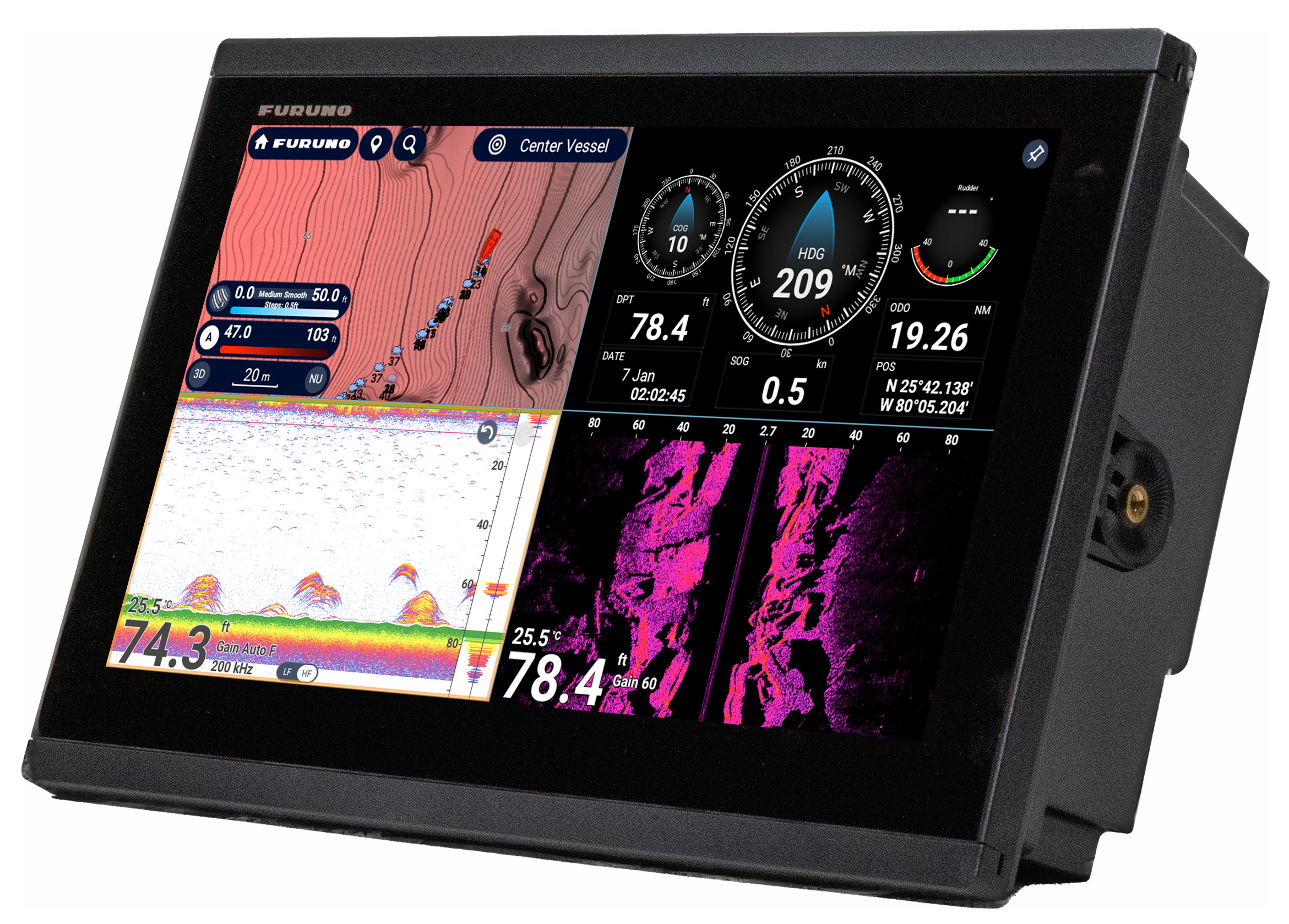
Furuno has two new fishfinders, the FCV585 and FCV620, that seem interesting. For one thing, better seen in a big picture, they are styled more sleekly than normal Furuno gear. More important perhaps, they incorporate Digital Signal Processing (here’s Chuck Husick on DSP) for cleaner, easier to understand imagery. DSP also improves automatic control, but the Furuno press release proudly notes that the units retain the company’s “long-standing and highly revered direct access knobs”. I do not know if Furuno’s DSP is equivalent to Raymarine’s HD (High Definition Fish Imaging), but I do know that the latter has earned the respect of some fishermen. I also know that it’s darn hard to directly compare fishfinders (can’t run them at the same time, can’t fake fish), and guys will be yakking about the relative merits of these machines for years to come.
I first researched forward looking sonar (FLS) back in 2002, and later tested an EchoPilot Bronze on my 25' Ralph. I really, really like the idea of being able to see underwater ahead of the boat (I like exploring, and Maine is ledge city), but so far have to agree with the general consensus that the available gear--from Interphase as well as EchoPilot--can't see very far or with much detail. But now Furuno has introduced the FL-7000 FLS purportedly capable of seeing "up to" 1,600' ahead of your boat (though the image above, bigger here, only shows a breakwater, or similarly easy target, about 15 meters ahead). Just putting its name on FLS will bring new attention to the category, and I imagine there's some truth to Furuno's claim that it's spent years developing the "best FLS on the market". It's also the most expensive at something like $4,000 (though I haven't seen that in print, and there's nothing about it at Furuno's site yet). The unit also has something called "Baitscope Mode" that I don't comprehend yet, and is capable of using pitch and roll information to stabilize targets. And I'm told that the phased-array transducer, from Airmar, has tested successfully at speeds of 40 knots. Could the FL7000 protect a fast boat from, say, just-awash shipping containers? That would be something! Hopefully, I'll learn more at Fort Lauderdale, still on as best I can tell.
PS 9:30 am: Fort Lauderdale not opening on Sat., maybe not at all.
Next week in Ft. Lauderdale I’ll get an on-the-water demo of the new Raymarine A65 along with its included Navionics Silver chart card…so details then, apparent strategies now:
* The A65 is a 6.5”, though full VGA, plotter/fishfinder (or plain plotter) that seems to incorporate Raymarine’s crisp digital sonar technology and some of the friendly soft key interface seen in the C and E Series. It does not support radar, a high speed bus, or even SeaTalk2/NMEA 2000, but it does seem to offer some bigger boat electronics goodness in a smaller package (and price, though I don’t have the exact numbers just yet).
* The A65 comes with a Navionics Silver CF card that includes full detail coverage of the entire US coast. My understanding is that this signals the beginning of Navionics’ three tier chart strategy—Silver, Gold, Platinum…good, better, best. All the details aren’t out but the idea is that users of at least some machines can upgrade through the tiers as desired; meanwhile Navionics can move features down through the tiers as competition dictates. Slick.
The total package seems like a big “hello” to Garmin’s 192/198 series, Lowrance’s NauticPath etc., and also, in a way, to NOAA’s imminent giving away of all U.S. raster charts. (And a note to readers from outside the States: sorry that your governments are not pushing vendors to provide more and better chart coverage for less money, but then again you don’t have a powerful politician trying to gag your met offices.)
How do they do that? The new JRC JLN-550 Speed Log at right is displaying not just 18k of forward speed over the ground (SOG), but is also showing that the bow is going to starboard at 1.8k and the stern to port at the same speed. The trick starts with a 4 beam 240 khz sonar transducer in the bow. The doppler shifting of the sonar pings off the bottom is used to get two axis SOG. The third axis (the stern motion) is calculated by adding rate-of-turn input from a gyro or ROT capable electronic compass. When bottom depths exceed 250 meters, the unit can switch to speed through the water (STW) using ultrasonics (2 mhz) to measure passing particles. Now this is big ship gear for sure—it starts at about $26,000, and the 265 pound transducer is termed “compact”—but accurate STW underway and multi axis SOG around docks would be very useful on medium size boats too. I’m hopeful. Airmar already has an ultrasonic speed transducer scaled for yachts (pdf brochure here). Now we just need a small, reasonably priced 4 beam sonar transducer.
Last week I mentioned (relatively) inexpensive side scanning sonar, and here’s what I’m talking about. This 7” diagonal Humminbird 981c, which retails at about $1,650, is a conventional 750 watt dual frequency (50/200kHz) fishfinder that’s also able to scan sideways about 240’ out and 100’ down at 262kHz. The image on the screen (bigger here) is the left side of a scan, showing a submerged barge (distorted by the scanning dynamics) and a pile of dumped logs. You can see from the numbers that the depth was only 11’ and the scan is only looking out 30’, but there are more screen shots on Humminbird’s side scan page that show pretty good detail at somewhat greater range. Of course, these are all company images; has anyone out there tried one of these?
I’ve gotten fascinated by side scanning sonar, largely because products are coming to market that are inexpensive and easy enough to interest sport fishermen and amateur Captain Cooks. I’ll have entries on those soon, but first let’s look at what can currently be done with commercial grade side scanning, usually done with a towfish. Above is the wreck of the 291’ SS Portland, which sank off Cape Cod with great loss of life during a blizzard on Nov. 26, 1898. The image, which is not a photo, was collected with a Klein 3000 towfish (below). In the larger version, fish are obvious near the bow, which, incidentally, is actually attached to the rest of the boat (the black area is typical side scan distortion created when the gear moves along the track shown as a line). Bigger images and a fascinating description of the Portland disaster are here, and lots more scans in Klein’s gallery section.
The croakers and rockfish just weren’t biting, but the research trip was terrific anyway. I’ll have more to say later about trying the latest incarnation of Maptech i3 and the Airmar factory tour, both very impressive, but today’s entry is about a little company you’ve never heard of called NSI (Nautical Solutions International). Google can’t find them but principals Mark Pringle and Floyd Phillips have been doing valuable, innovative (behind the scenes) work with 3D bathymetry since 1996. You may have seen it as contour modules in Maptech or Raymarine software, or as Bass Tracker on ESPN (and there’s more to come). Their web site is informative, but doesn’t show you how their office is right next to the marina where they keep two test boats ready to run year round. The latest, the Defiance 260 above, is totally tricked out with i3 gear; besides the big scanner, those are Weather Channel Marine and SkyMate satellite antennas up there. Such a deal: Maptech sponsors a great boat for showing off i3, which the lads at NSI also use to tweak the 3D fishfinder (and take a break from coding). Nice!
In a review on Yachtingnet Chuck Husick discusses the Lowrance LCX-104C fishfinder and chartplotting capabilities. It's a fairly neutral review, more of an extensive product description.
"Lowrance’s ASP (Advanced Signal Processing) noise rejection system automatically optimizes fishfinding performance under typical operating conditions. A small external LGC-12w GPS/WAAS receiver provides the navigational data. The LCX-104C runs Navionics digital cartography in conjunction with Lowrance’s MapCreate custom mapping software. Two MultiMedia Card (MMC) cartridge slots facilitate simultaneous use of a Navionics cartridge and a blank data-storage cartridge or one custom loaded with MapCreate cartography. The system’s NMEA 0183 output lets it interface with other display devices, as well as the boat’s autopilot."
A short article going back to 1957 when Carl Lowrance invented a small electronic box that flashed instant water depths and possible fish targets, and looking forward to a near future where anglers will find their lake depth screens will appear in 3-D effect to more easily visualize the haunts of fish.
"In my fishing boat the other day I turned on a state-of-the-art Lowrance 104 unit that combines sonar with GPS and mapping capabilities. It's the fishing version of shock and awe. On a split-screen as clear as color television, the Lowrance 104 showed the bottom depth, possible fish or bait targets and bottom hardness — and that's just one side of the screen."(Lowrance at Amazon.com)
"The X135 has 4000 watts peak-to-peak power for depths to 1,000 feet. It comes with “Fish I.D.” This feature automatically interprets sonar echoes and displays them as fish symbols. The “FasTrack” feature lets you speed your boat over the water and watch the bottom contours and depths while you hunt out the perfect spot."