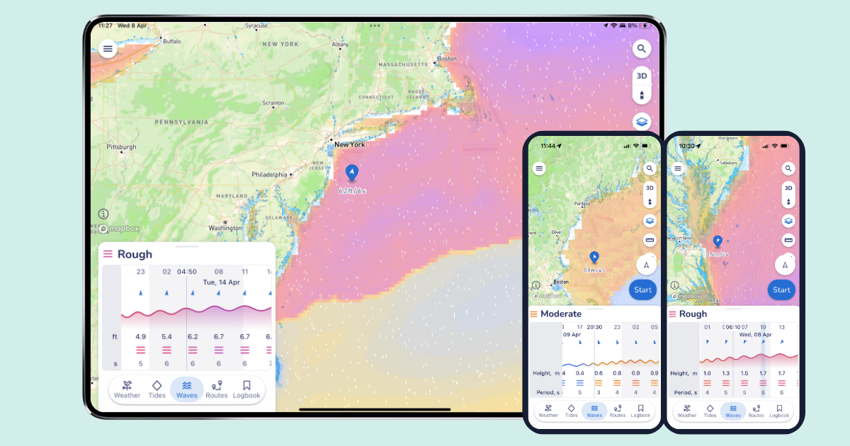
Panbo

Category: Weather

Saildocs, a Gram Schweikert tutorial

Jun 3, 2008

Grib_for_Panbo_cSchweikert

Saildocs is the baby of West Coast weather guru Jim Corenman, who with the support of SailMail provides a free e-mail server able to feed low bandwidth weather data (and more) to boaters. While not as pretty as the free, but limited Grib.us {or similar PassageWeather}, or the costly but widely used OCENS WeatherNet {or ClearPoint}, it provides a multitude of weather data in many formats right to your in-box for free. All of the Saildocs instructions can be retrieved by e-mail (info@saildocs.com) or from their not-really-meant-for-surfing Web site.  Below are my brief tips and tricks to using Saildocs:

Continue Reading

Road trip, w/ mini sat comms

May 17, 2008

Mini_sat_comms_lr_cPanbo

The electronics road trip was a blast, and it seemed appropriate that I drove it with three (3!) modes of satellite communications on my dash board, bigger image here.

Continue Reading

Bushnell ONIX400, & XM/Sirius merger

Mar 24, 2008

Bushnell_ONIX400_w_XM_weather

It took a while to get real, but just this morning I received assurance that I’m the list to try one of these intriguing Bushnell ONIX400 handheld plotters capable of receiving XM Satellite Weather and Audio (once they can get ahead of orders and free some units up for the media). It may be oriented to hunters, but couldn’t it be useful to boaters who want a relatively economical way to carry live satellite weather wherever they go? And, besides, how hard would be to add charts to a handheld that can already do topo and photo maps?

Continue Reading

PAW, nifty & free Smartphone weather

Feb 21, 2008

Usne_new_frad_anim_none

A great tip from Panbo reader Russell D.: The Space Science and Engineering Center (SSEC) at the University of Wisconsin offers a free PAW (PDA Animated Weather) service that looks like it would work well on Web enabled PDAs and Smartphones (also as a Google Gadget). That animation above is the New England Regional 15 Minute image and it even shows something called NSSL Forecast Radar, i.e. a computer guesstimate of where the precip will be in an hour (I grabbed the image at about 11pm). I’ve heard of this technology, but this is the first time I’ve seen it. PAW covers most of the U.S., often in metro detail, and a scattering of foreign locations. The data for any given place varies, often in interesting ways (research center!). Like check out New Zealand with jet stream and radar. Unfortunately I’m only peeping at this on the Web. You readers able to try PAW with something mobile…please report back. Thanks Russell! Oh, and if this pushes your button, also check out Memory Map’s Weather Radar, which may well be a more consistent, and data efficient, resource.

PassageWeather, first impression

Feb 6, 2008

PassageWeather screen cPanbo

PassageWeather.com is apparently brand new, but impressive, offering free 7-day sailing forecasts for all oceans, updated 4 times a day. The interface seems clean and fast, data sources are explained, and you can download forecast charts easily. The region organization is nice too, and note that the ocean race routes are always forecast, so you can, as above, quickly see that heading, say, Norfolk to Bermuda today could be one fast passage, in the right boat. PassageWeather is no where near as ambitious as ClearPoint, but it seems well done. Your thoughts?

Nobeltec alert, & other product problems

Dec 21, 2007

Nobeltec_Alert

Yike. It seems that Nobeltec has guaranteed its support staff a busy holiday season by issuing the ominous sounding alert above along with update 9.3.2240 to its VNS and Admiral charting software. The exact chart regions/software combinations that have the problem are listed in the bulletin, and include the Northstar 972 but not the Simrad GB60. The good news for anyone who has trouble with the update is that Nobeltec recently extended its support lines to 13 hours a day during the week and 10 hours a day on weekends. The bad news for some is that with this update Nobeltec removes the ability to import S57 vector charts—for most people that means the free ENCs offered by NOAA—and even disables those already imported.

Continue Reading

ClearPoint weather, anybody else tried it?

Nov 7, 2007

Clearpoint_screen_cPanbo

I’ve been trying ClearPoint High Definition Weather for a couple of weeks now, plus I talked to some of the team at FLIBS. This is a very ambitious operation. The ClearPoint goal is to provide the richness and simplicity of dedicated XM and Sirius satellite weather anywhere on the globe, delivered by Internet. Plus they’re aiming to provide more exotic data—like 1 kilometer wind forecasting of certain sail racing hot spots and game fish revealing altimetry/chlorophyll imagery—for certain niche marine markets. And they seem to be working with numerous nav software/hardware developers to provide integrated packages, even automated weather routing.
   At any rate, check out the full size screen shot of ClearPoint’s PC client software above. The icons at the top—wind, fronts, lightning, hurricanes, and text forecasts—show what I’ve chosen to display on screen. With the window lower right I can page through those various elements, clicking for specific places on screen. And the icons below show other data types I could add to my mix. I like the interface quite a lot and some of the data, like far offshore lightning, I’ve never seen in any weather product before. But buying the ClearPoint service is not trivial, and that does not include the cost of offshore downloads, which could be in the .5 meg per hour range (there is a low bandwidth mode, and ClearPoint is working on total download size controls). Interested? There is a free trial; please report back!

Hurricane tracking, XM & more

Aug 20, 2007

Garmin_XM_Hurricane_Dean_lr

Panbot Allan Seymour (thanks!) sent in this image of Hurricane Dean showing on his XM-enabled Garmin. It also happens to show the southern limit of XM’s cloud coverage coverage. Which shouldn’t be confused with the southern limit of the area covered by XM’s satellite, though it’s close. Meanwhile, gCaptain put up a good list of online hurricane tracking maps, plus a link to great info on Google Earth storm tracking. Tis the season.

HF weather broadcasts, & DMS, revisited

Aug 16, 2007

CamslantWhen I first mentioned the USCG’s need to replace its HF weather radios, I had a hard time getting into the Document Management System (DMS) where any us can make a comment or see other people’s comments. Well, apparently some 900 folks did figure out DMS, and the vast majority of them are asking the government to spent the four million dollars it will take to replace 20 transmitters. I learned this from Joe Hersey’s rec.boats.electronics post and there’s also a new NavCen page on the subject. There are 10 more days to make comments, and the USCG would like more, but neither of those references tell you how to find your way around http://dms.dot.gov/. The magic Docket ID/Number is 27656. Entering that in “Simple Search” or “Comment/Submissions” will get you to the HF Weather issue. Yes, it seems a little nuts that the government is going to all this trouble about a piddly 4 million (especially considering Iraq), but wouldn’t it be a shame to lose HF weather broadcasts?

Charts etc., we've just gotten started

Jul 11, 2007

Google_Earth_south_up_cPanbo

Pardon a slightly meta sidetrack, but two bits of the massive media flow got my attention. One is a Wired article about Google Earth which makes the case that the future of cartography is user data. “We're all mapmakers now, which means geography has entered the complex free-for-all of the information age, where ever-more-sophisticated technology is better able to reflect the world's rich, chaotic complexity.” Then there’s the news that scientists have calculated that the diameter of the globe is about 5 millimeters less than thought. Not even a quarter of an inch! Among other techniques, they used atomic clocks, quasars, and 70 radio telescopes to establish base lines, and they say that the precision they are after will help to better measure phenomenon like global warming, ocean currents, and tides. As amazed as most of are by all the information now available on a yacht’s bridge, I think we’ve just gotten started. (For some really interesting dope about related planet dimensions, and early cartography, check the beginning chapters of Nigel Calder’s How to read a nautical chart, which also has practical uses!) 

PS 7/12: It turns out that Captain Richard Rodriguez, who has a thing or two to say about the Boston ferry collision (see his fine blog), has also used Google Maps to mark the most frequently hit rocks in the San Juan Islands. What I’m talking about!

Milt, from mid Atlantic

Jun 19, 2007

Med Bound 2007

I’m way behind on work, not to mention the gizmo preparation, that needs doing before Bermuda (wow, Bill and Gram were fifth over the line and third in class corrected), so I’m turning it over to Milt Baker. These snippets are from today’s noon report, filed from almost the midpoint of the Med Bound 2007 Bermuda-Azores leg:

Ships are few and far between out here.  We nearly always pick them up on AIS before seeing them on radar.  Moana Kuewa (which has the same Furuno FA-150 AIS unit we have) clearly has the best installation {not trivial} and picks up the ships first every time, sometimes as much as 20-30 minutes before they show up on the AIS units aboard Salty Dawg and Bluewater.

Continue Reading

Write the gov'ment, HF weather & AIS B

Jun 15, 2007

Two issues U.S. boaters might want to comment on:

1. Apparently the HF transmitters the USCG uses to send out offshore weather forecasts—voice, fax, etc.—need to be replaced and the government wants to know if it’s worth the money. If you use SSB or HAM for NOAA weather, or ever plan to, you might want to look here for ways to speak up. (I managed to find the electronic comments the other day at http://dms.dot.gov/, but can’t get there today).

2. Yesterday the FCC issued a request for comments regarding the granting of waivers so that USCG approved Class B AIS transponders can be used in the U.S. while the Agency works on a final rule making.  The FCC’s online search and comment software is also clunky, but try going here to make comments, and look here to review them (nothing so far, but some interesting older stuff, like Orbcomm’s interest in providing satellite AIS tracking). In both cases use Proceeding # “04-344”.

Garmin's new XM Weather, first impression

Jun 7, 2007

Garmin XM weather c Panbo

I’ve got the new Garmin GXM 31 hooked up to the 545s, and am once again impressed with how deep this “product line refresh” really went. I’ve tested Garmin XM weather on several devices over the years, and saw the interface get better and better. But they threw a lot of it away in favor of an easier, if less tweakable, presentation. For instance, the only control you have over the main chart overlay above is weather on/off, Nexrad animation on/off, and legend on/off. But the data selection is good (yes it rained shortly after that photo), and for more weather you go to the main Information menu where you’ll find a selection of weather presets, each modestly tweakable from the menu key. I didn’t have the manual at first, but pretty much figured out all the possibilties on my own.

Continue Reading

Garmin 545 videos, thanks Bluewaterpirate

May 30, 2007

Garmin 545 videos

I’ve been feeling mighty guilty about my oh-so-slow testing of the borrowed Garmin 545. So it was particularly great to find that a fisherman named Tom has posted a useful series of stills and videos illustrating many 545 features. His Bluewaterpirates Phanfare album may be called “XM Music Functionality” but you’ll find dope on the new Vision charts plus a nice “new section” showing all the XM weather functions using a dramatic offshore low, and more. Enjoy.

UGRIB, nicely done and priced right!

Apr 5, 2007

Ugrib cPanbo

In Maine speak, that low pressure system which blasted through here last night was a “corker”, leaving at least 10” of snow which has a gluey consistency unfriendly to snow blowers and plows. Panbo world headquarters is still digging out! Now, of possibly greater interest, that screen above is from a new and quite nicely done weather program called UGRIB. It lets you download and display forecasts for any section of earth as generated by NOAA’s “global numerical weather prediction model.” And it’s all for free, thanks to the folks at GRIB.US. You only get wind, pressure, and precipitation—and, of course, you can find far richer weather data on the Web—but one beauty of GRIB files is their compactness if your data pipe is limited…like, say, a sat phone out in the ocean. GRIB numerical data can also be animated, as UGRIB does, and used by routing programs.
   Meanwhile, back here in Maine, a 40’ scallop boat sank Tuesday night as it tried to return home ahead of this storm. The crew is fine, apparently because they were well equipped with EPIRBs, survival suits, etc. The Luke & Jodi even had some sort of transponder such that the owner could track it from home, though that let to some confusion. At any rate, the crew did everything right according to the Coast Guard, except perhaps deciding to supply the liferaft with a case of beer and bottle of vodka “to keep them occupied while they waited to be rescued.” That led to problems (and more detail here).

XM + Sirius, just when the live weather war heats up

Feb 20, 2007

Northstar weather cap

It’s not every day that the New York Times puts a tech merger on the top of the front page, but amazingly the XM/Sirius merger, rumored for ages, never came up (around me) in Miami…despite lots of news about their competing marine weather services. Northstar, for instance, previewed its 6100i Sirius Weather product, which makes terrific use of softkeys to mix and view all those data elements (a real challenge). For instance, that “Overlay” key above (bigger here) let’s you page through six different customizable data mix presets, each represented in the little window with icons, and you can further tweak the data presentation by setting ranges if you want.
  Furuno was also previewing a Sirius weather product (PDF brochure); the interface seemed much more rudimentary, but since Furuno is using a new generic Sirius receiver (Northstar’s is their own) and there’s also new Sirius weather PC software in the works, a boat might be able to use both on the same subscription. Sirius Weather was also showing on a Maptech i3, which already runs XM, and as part of a ambitious new SkyMate product that includes GPRS and Orbcomm communications. And Raymarine introduced Sirius Weather for the C-Series, which incorporates a cool implimentation of Sirius audio, including volumn control, easy presets, notification of favorite artist and some other subtleties. Audio is already built into the E-Series Sirius receiver—all these receivers, in fact—but the audio interface won’t come for a while.

Meanwhile, XM’s big news is species-specific fish finding data (sorry for poor pic below), as well as extended wave, wind, and surface pressure forecasts and more Canadian data, including radar (Puerto Rico too)—all included in the same $50/month Master Mariner subscription—plus there’s some exciting new hardware and relationships in the works. In short, there’s a hell of a Sirius/XM competition going on just in this little marine weather segment. What does it mean if and when the two become one? Your thoughts please!

XM fish forecast c Panbo crop

Less expensive XM Weather, Navionics Gold+ too

Dec 5, 2006

Bushnell-ONIX400CREliBoat made a good catch last week, spotting this Bushnell ONIX400CR GPS and XM handheld. The specs, as spied out by the sat radio blog Orbitcast, look impressive—waterproof, 3.5” screen, XM weather & audio, aerial and satellite photo overlays—and all supposedly retailing for $500 when the product ships in February. That’s a big discount from the Garmin handhelds that offer this same great ability to carry your XM subscriptions from boat to car to house, etc. Mind you that Bushnell shows no interest in the marine market; its thing is hunting, as shown by its Web write up for sister product ONIX200CR. Still, I want to try one and see if it might make sense, even without nautical charts, as a boating accessory. This product, by the way, is an ‘honoree’ in the Wireless Peripheral category of the 2007 CES Innovations Awards, always a geekerrific list.

More good news on the cost of marine electronics front: Navionics is apparently going from XL3 to XL9 Gold+ chart cards, three times the area for the same $200 price. That’s the whole East Coast and Northern Bahamas on one card, with full NOAA chart detail (unlike the Silver all-one-cards), plus “enhanced port services” POIs (flawed though everyone’s may be), coastal roads, and a mail-in coupon for a free Fish’n Chip bathy card. This price drop is not on Navionics’ Web site yet, and may not be effective until 2007, but Peter James of Jack Rabbit Marine has the scoop on his new blog, askjackrabbit.com. A blog by a guy who professionally installs marine electronics? Now there’s some really good news.

AIS-equipped weather bouys, multitasking big time

Aug 3, 2006

NOAA bouy vis SeaCasI’m still looking for more detail on this story—like how many buoys, and when?—but I understand that the U.S. Coast Guard and NOAA are working together to put AIS transponders on many of the offshore weather collecting buoys. Of course that means that the buoys will show up as targets. But also broadcast will be the sensor data—current, wind, visibility, etc—which will supposedly then get ashore (and into the satellite and other services) more frequently, plus be available direct to anyone with an AIS receiver and the right software. But that’s not the only purpose, by any means. The transponders are apparently set up to forward received target info via Iridium to the USCG Maritime Domain Awareness Program. Hence, “the buoys would form a ‘picket line’ around the continental and southern Alaska coast that would detect AIS-enabled ships as they pass in near real-time to enhance maritime security, as well as support safe marine transportation for commerce.”
     (Images graciously passed along by Fred Pot)
NOAA AIS bouy 2 via SeaCas

PS 8/8: I stand corrected: while the transponders described above are being “discussed”, what the USCG is actually working on right now is simply placing “AIS receive-only equipment on certain weather buoys in order to receive AIS signals from ships further offshore than can be done with shore-based receivers.”

Sirius vs XM, the coverage footprints

Jul 26, 2006

Sirius-xmorbitanimLooking at the animated version of this graphic too long may make you ill, but it does nicely illustrate the very different schemes that Sirius and XM chose in their efforts to blanket North America in audio and data, including, of course, our recent obsession…live marine weather. Both schemes seem to work fine around the U.S., especially on boats with their naturally wide open sky views, but how far offshore, north, and south can you receive Sirius or XM? A lot of cruisers would like to know, but the company Web sites seem vague on the subject. For one thing, I don’t think they themselves are positive about their footprint edges, and don’t want to over promise. 
   Another issue is that XM and Sirius may broadcast into countries where they are not licensed to, and where someone thinks they should be. You may recall a long period when Canadians could only subscribe to satellite radio using U.S. addresses, even though most could get it fine. XM and Sirius were not bragging about their Canadian coverage then! Both Audio services are now licensed in Canada but, head’s up, Sirius Weather isn’t yet. Which brings us to some legalese in the Raymarine Sirius literature suggesting that your expensive weather receiver might not work if youSirius Coverage go outside U.S. territorial waters. Not true; I checked!
   And judging from the unofficial footprint map kicking around the Internet (right, and slightly bigger here), Sirius will deliver fine service in Canada, out past Bermuda, down to around Antigua, across to maybe the Canal, and actually further into Alaska than shown (so I’ve heard). I understand that XM is similar except that it doesn’t reach as far south, which seems confirmed by the unofficial XM footprint map below, created by WxWorx, the company that’s developed a PC hardware/software system for XM Weather. They’d like to hear more reports from XM users on the edge, and I’d like to hear from anyone who knows more about how far either service reaches. Thanks.
 Xmmap_full

PS, 7/28: We’ve been kindly sent links to a good collection of footprint maps and to a related forum discussion in which one poster describes getting XM in the Azores using a dinky home antenna (though it was before some changes in XM’s satellites).

Cell weather radar, dirt cheap or DIY

Jul 21, 2006

Greenbayloop

How about that! The Memory Map Nexrad function for Smart Phones that I tried and raved about now does animation, at right, plus it’s been debundled from the charting software. $10 and it’s yours, no subscription needed, and data use is efficient and user managable. (By the way, developer Richard Stephens may be seriously field testing this product over the weekend, as he again sails the Mackinac aboard Flight Simulator. He says the course is a thunderstorm alley. Good luck, Richard!) 

Meanwhile, Panbo reader Bob Mueller wrote in to say that he’s figured out how to get simple Nexrad images onto his not-so-Smart Motorola v710: I host my own website on the residential DSL line in my home, and I created DYI cell radara page with a custom PHP script that I wrote. The PHP script goes to the ADDS (Aviation Digital Data Service) website, pulls a NEXRAD radar image for the area where I boat.  The image displays a very large area, that would not be easy to interpret on my cell phone screen.  My script then crops the image to the exact resolution of the phone screen.  The script saves this cropped image to the hard drive on the web server for display on my cell phone's screen via the phone's web browser.  (I would be more than happy to share the code, it is only a few lines!)  {Send me a note if you want that code — Ben}.

PS Thanks to Gizmodo for picking up on my Sirius & XM weather testing (even if they somewhat misinterpreted my ramblings); we’re getting major hits, which I find very auspicious as today I officially became sole proprieter of www.Panbo.com. Wishing all a great weekend.

Sirius vx XM, doing thunderstorms, (updated)

Jul 20, 2006

RayE Sirius Thunder bumper

I do feel a little guilty. My buddy Jamie was out there in those islands with friends and family on a Maine Cat 41, and I knew it, but didn’t think to call his cell and advise him about just where those monster thunderstorms were tracking Tuesday evening. Yeah, they’d heard the warnings beeping all over the radio, but still didn’t know if a cell would actually hit them, or when, until one rolled over the horizon (which surely happened, as shown so vividly above). Sorry, Jamie!

It was too bad because I could really see what was going on, having fired up both the Sirius and XM live weather services I’m testing. My goal was to see how detailed and accurate the satellite information is, and more specifically if it could have helped me get around the worst of the weather in a reasonably fast boat. Conclusion: Yes, if the cells aren’t coming at you in a solid line, and the boat is fast enough. Of course there are numerous subtle differences between the services, and a few anomalies. In the latter department, observe the two photos below, Garmin XM on top (bigger here), Raymarine Sirius below (bigger here), taken at almost exactly the same time.

For some reason Sirius was not tracking any storm cells in New England that evening, i.e. was not generating the arrows that indicate speed and direction, and can be clicked on to reveal more information like chance of hail. XM’s tracking, which nicely indicates the dimensions and speed of the cell, was working fine, but its analysis of precipitation seemed to be markedly off. I was there, and the rain was tapering off just as indicated by Sirius, not about to pour buckets as suggested by XM. Yes, XM shows a 4 minute delay, but I don’t think Sirius was much fresher (it should be time stamped). Hell, that data has to go from the radar station out to a network, through the processing facility, up to the satellites, and back down to these machines. A four minute delay is damn good, especially given this level of detail for the whole U.S.A. And that’s the real story here; I would really like one or the other of these services at my helm. More tomorrow.

Garmin XM Thunderstorm

RaySirius Thunderbumper

7/21 Update: Sirius and data provider WSI are trying to figure out why those storm cells weren’t being tracked (I see a similar problem today off Long Island), and I have a call into XM about why their Nexrad might be a little off. In the meantime, a couple more notes to go with these illustrations:

* I like how Raymarine overlays the weather on a simple outline map, instead of charts, but it would be good to add some landmarks for orientation, like maybe port names. I found myself turning all sorts of stuff off on the Garmin charts, stuff I’d like to see otherwise, so I could see the weather better. On the other hand, the streets and names on the Garmin were useful when overlaying cloud cover, as seen above. Sirius does offer cloud cover, but does have Canadian weather radar.

* Garmin’s new “Presets” weather interface is excellent. See the “Storms” lower left on the screen; push the Next Preset soft key and you get the “General” preset, then the “Sea State” preset. The names don’t really matter as you can go into the weather setup area and customize just what mix of data you want for each preset. Moreover—and Garmin has had this for a while—you can specify presentation of individual data types by zoom level. That’s a little harder to get a grip on, but also helps you mix all the data available in sensible ways. I encourage Raymarine to steal the preset concept, and maybe the zoom level too, ASAP! 

Live marine weather, Sirius vs XM, the prolog

Jul 12, 2006

Sirius Weather E-120 Panbo

I looked forward to the battle of XM and Sirius marine weather services, and now it’s here. Right now, down in the shop, I’ve got Sirius Marine Weather running on the E-120 and XM Marine Weather running on the Garmin 3210 (and both are ready to go aboard Ralph, which I launched yesterday, yeee-ha). That screen shot above is Sirius on the E, bigger here. You’ll notice Nexrad precip radar, storm cell vectors, water temp, wind arrows, outlines for NOAA text forecasts, and of course the red Tornado Warning area. There’s a lot to these services, and to the interfaces needed to get the most from them. I’m wondering if any of you have experience with either service, or would like to see particular data screens, or just have opinions about subscription weather? Here’s a good page to see what XM beams down, and here’s a similar list for Sirius (click on the FAQ). Don’t be shy!

PS 7/13: An unusual aspect to the Sirius screenshot is that we almost never get Tornados in this part of the world, and it was nice to have a plotter beep me about the possibility. On the other hand, no tornados actually materialized (no fault of Sirius). Below, bigger here, is a Garmin XM image from last evening. That rain definitely did come my way.

Garmin storm mode Panbo

Maretron Weather Station, first impressions

Jun 22, 2006

Maretron WSO100

As you may have noticed from the antenna farm, I’m trying the Maretron Weather Station announced last fall. It’s hard to imagine an easier physical install…unscrew a T in the NMEA 2000 backbone, add new T and the WSO100 sensor, power and data done. The Raymarine E, plus RayTech 6.0 on the SeaTalk HS bus, immediately got the ultrasonic wind speed and direction data. Coastal Explorer got it too, as no doubt other PC programs would, via the Maretron USB Gateway (in other words converted into NMEA 0183 messages). Air temperature, barometric pressure, and relative humidity are a different story. There are NMEA 2000 and 0183 sentences for this data but so far nothing I have reads them all except Maretron’s own display. Obviously that’s also true for derived values like wind chill and dew point. At any rate, the display did need updating to understand the WSO100 and put up new screens like the one above, and Maretron has developed a nice program called NK2 Network Analyzer (below, and bigger here) that can update any device on the backbone. (PS: Just noticed that Maretron has put up a demonstration program).

Maretron N2K NA

Cellular weather another way, amazing

Jun 7, 2006

IMG_3416

The impressiveness of the above, bigger here, was no doubt heightened by how BIG the weather was around Boston today. I was supposed to go boating on a 44’ Sea Ray but even a few hours tied up in a very protected marina felt heroic given the volume of wind and rain. The project was interesting and I’ll tell you about it tomorrow, but today I’ll just show you the wild and crazy phone one of the guys pulled out. That is the Weather Channel playing on that Verizon XV6700 and it looked and sounded quite good. I was tickled a few weeks ago just to see just static Nexrad on a phone; this TV feed included not just animated radar and sat imagery but a live forecaster (as long as high speed EvDO is available). And it’s source was not some Web site but rather the owner’s own home TV setup which is equipped with a Slingbox, able to serve whatever channels he already pays for out to the Web where he can watch them even when he’s not home, even when he’s rolling around on a boat. The software is SlingPlayer Mobile and apparently it can even control a Tivo type recorder. So beyond live Weather Channel are a lot of other intriguing possibilities.

Garmin 478, another big step

Mar 29, 2006

Garmin 478 panbo

I suppose it was predictable, but it’s still amazing. The Garmin 478 above has all the XM Weather and Audio abilities that distinquished the 376C, and it comes loaded with all U.S. charts and all U.S. and Canada road maps. It’s fast too, even the ‘Find’ command is not slowed up by what must be a zillion POIs, nav aids, intersections, etc. stored somewhere in that little casing (and hence I’d bet that Garmin has sped up Find in the first all-U.S.-charts 192C I tested last summer).

Not that the 478 is perfect, even if there is nothing like it out there. For instance, these are the new G2 charts, but apparently the 478 will not be able to show the vaunted perspective view. I do gather from the spec page that it will show the photos available on G2 cards, and the screen above (bigger here) does look richer than regular BlueCharts. But, as good as this screen is, I find myself wanting to plug the 478 into a bigger monitor, maybe use a wireless keyboard and mouse with it too. The unit lets you use an expensive XM subscription anywhere you go but in some of those places, like a boat, you may want to expand the system. Just a thought, probably inspired by how rapidly this unit has evolved over the years. 

I should also add that the Panbo reader who recently complained about the “Surface Wind” coming from XM to this machine was right; it’s old. He tells me that Garmin has acknowledged the problem and is working on it, but I also noticed this time around that you don’t get predicted wind and wave model data, something the new Sirius Marine Weather is very good at.

Garmin also announced a new pair of radar scanners this week, this time inside a smaller, 24” diameter casing, and with more emphasis on the digital processing going on in there. Finally, though Garmin hasn’t yet promoted it, many of its new plotters apparently do support AIS. The 478 is not one of them but I think I’ll soon get the chance to try it on a 3210.

Garmin 376C, holy mackerel!

Nov 9, 2005

Garmin376c Weather

I would have posted earlier today, except that fooling with this Garmin 376C vividly reminded me (above, and bigger here) that the spell of dry, sunny weather was about to end. So I spent some hours winterizing the fleet, all the while watching the clouds thicken up from below and above. I could also see an animation of all that rain moving across New York state, plus the lightning strikes, the frontal lines, pressure gradients, wind predictions, buoy reports, etc. etc. It is phenomenal how well you can see all this info on the 376’s little screen. The display itself is exceptionally bright and detailed, and Garmin has also done a good job at letting you view the weather data mixed together or one element at a time. And, get this, I was also listening to XM radio (below). I’ve been trying the 376C intermittently over the last month or so, and am very, very impressed. It really makes sense in terms of carrying your XM weather and audio subscriptions with you on land or sea. The only con I can think of is that BlueCharts have gotten pretty expensive relative to the competition, but maybe that will change.

The Garmin 276C was one of my 5 Sail magazine “editor’s picks” for innovative, important marine electronics introduced last year. I’m working on my 2005 picks right now, and the 376C is definitely a contender. If you have suggestions for other hardware or software that should be on the list, please let me know.

Garmin376c xm audio

Wilma & Ft. Lauderdale Boat Show

Oct 24, 2005

Wilma Mon 9am

Monday, 9:00 am: on Friday afternoon the organizers of the Fort Lauderdale show postponed the opening from Thursday to Saturday, but I’m beginning to wonder if it will happen at all. As you can kind of make out in the radar shot above, Lauderdale is right now experiencing the worst portion of the storm’s eye wall. SSE gusts in Miami have hit 95 knots, and haven’t started to taper off yet. Wilma is moving fast, so South Florida will soon be able to assess how badly it got hammered. But even in good conditions the amount of boat handling, tent building, etc. that goes in this show is amazing. Of course the show is trivial compared to other problems Wilma is causing.

Free the weather, my ass!

Oct 19, 2005

Free the weather bs

Argh! I haven’t gotten too exercised about Senator Rick Santorum’s bill to limit NOAA’s distribution of weather forecasts because I thought it simply too ridiculous to pass, but yesterday I came across this steaming pile of pure double speak. “Free the Weather” is a disinformation campaign run by CWSA—a trade association for the commercial weather industry—meant to support Santorum’s bill. The big lie is that NOAA’s National Weather Service is currently not required to dispense weather to the public, and has sometimes been tardy. That’s like arguing that your local fire department is not legally obliged to fight fires. So what?…that’s what they do. In fact NOAA does an amazing job of distributing data and forecasts both to the public and all the commercial interests that want to add value to it. And never mind that Santorum’s bill restricts distribution to "a set of data portals designed for volume access by commercial providers." Check out FreeTheWeather.org and see if it makes any sense to you. (For instance, they post an interesting series from the Miami Herald about frustrations at the Hurricane Center, but does they support the Santorum bill at all?) You might get mad, and you might want to contact your Senators and ask them to free S. 786 from its misery.

PS One of the neat things NOAA does, I think, is to give the public access to the hurricane forecaster’s discussion notes. It’s geeky stuff, but today you can learn that some of the computer models of wicked Wilma have her coming closer to New England than the current 5 prediction track shows. Damn! 

Hurricane warnings, oldee style

Aug 26, 2005

 Oldtime

Hurricane Katrina whacked south Florida fairly hard yesterday and now it looks likely that she’ll power up and smack the northwest section of the state early next week. Per usual, there’s an extraordinary amount of data and valuable prediction information at the National Hurricane Center’s web site. Hurricanes are truly meteorological loose cannon, but it is amazing how far our ability to forecast them has advanced. I got to tour the NHC facility in Miami in early 2004 and was bowled over by the high levels of technology, data i/o, and brain power. That was the year that NHC’s back testing program indicated that their forecasting was good enough to begin issuing 5 day track predictions, which have no doubt saved lives and property since. By contrast, observe above how hurricane warnings were delivered to sponge boats off St. Pete, Florida, in 1938 (from NOAA’s online photo library).

Now, no idiot U.S. Senator (carrying water for a few private weather companies) is going to stop NOAA from distributing hurricane information, but, as you likely know, Senator Santorum of Pennsylvania does have a bill in process that might severely limit its ability to share less critical information. BoatU.S. has just posted a good editorial on the issue. Following one of its links, I found and used an easy e-mail form to register opposition to the bill with my senators. Why don’t you? 

Update, 8/28: Naturally I’m curious if Katrina could reach Maine with any force, and I now see that the NHC has a new series of ‘experimental’ wind graphics that are quite valuable. This one shows me that the models now predict a 5–10% probability of over 50 knot winds on Thursday. Hmmmmm. Note that it can be animated if you click on ‘loop’.

Weather Underground, no politics

Aug 12, 2005

Weather Underground, so goodIf you have a fast Internet connection, you also have a zillion good weather resources at hand. I wouldn’t dare to say which are best. But one I’ve gravitated to over the years—even paid a tiny subscription fee to—is the Weather Underground. I think it started as a university science project, which may account for the name referencing a really desperate and counter productive 60’s political movement. Whatever, it’s great. The screen shot at right (bigger here) shows how you can zoom in on a NEXRAD radar animation which you can also customize to your taste. Wunderground now even identifies storm cells, which I’d only seen before on the high end satellite products from XM and The Weather Channel Marine. But it was interesting yesterday when that cell shown over Penobscot Bay sprung up right over my house. 12 minutes earlier it didn’t show on NEXRAD at all. In other words even the fanciest tools couldn’t have kept you out of the way. The front did clear the air though, making for a great first day of the Maine Boats & Harbors show in Rockland, which is where I’m headed. Have a wonderful weekend!

SailFlow & FishWeather, how did I miss these?

Aug 9, 2005

SailFlowI was a little stunned this morning to discover two very interesting and ambitious marine weather services that seem to have sprung up fully formed, but without my knowledge! SailFlow and FishWeather are sister services, each offering tailored weather products either graphically via the Web or a WAP enabled cell phone (there are lots), or via a regular voice call. The services boast their own weather sensors covering a lot of the U.S. coastline, plus their own meteorologists and even computer modeling programs (in addition to public resources, of course). It turns out that both are the spawn of WeatherFlow, a company which has spent 15 years building a “national coastal mesonet with a presence in over 20 states…The WeatherFlow staff of engineers, meteorologists, and IT professionals are dedicated to increasing the understanding of the complex nature of climate within the coastal zone.” I intend to try out at least each service’s free month trial Web subscription. By the way, Eli of EliBoat—whom I had the pleasure of meeting last week—has been using WSI live satellite weather, which is a whole other animal than SailFlow. He posted some comments yesterday.

WSI + Sirius, oh goodie

Jun 22, 2005

WSI nat fronts

I missed the fact that WSI, the company behind Weather Channel Marine, inked a deal with Sirius Satellite Radio in March. "Our goal is to offer the gold standard of marine services”. This is good news, as it should heat up the competition between WSI’s service, now only available on PCs (including Maptech i3) via a single satellite, and the XM Marine Weather that can be had either on a PC or on Garmin network plotters. I’ve been watching the “live” weather category closely, and have tried at least the early PC and Garmin products, and was very impressed with how much detailed and macro weather sense I could get easily. In fact—odd timing—I was trying out a pretty good GRIB weather tool last night, but without the Nexrad radar and frontal line predictions, I missed the wet squall line that’s passing through here this morning! Above, and bigger here, is part of an old Weather Channel Marine screen that just suggests how you can see animated Nexrad combined with current and forecast fronts…very effective. A face off between giants Sirius and XM as providers of top notch U.S. coastal marine weather should lower subscription and hardware costs, open up new platforms, and really make boaters aware of this valuable service.

Charlie Barr's record

May 22, 2005

RaceWeather2

Yike! Above is the OPC’s prediction for 8 pm tomorrow night, my time. Today, 20 of the mightiest sailing yachts on the planet will set off from New York in a Transatlantic Challenge meant to celebrate, and smash, the 12 day, 4 hour race record set by Charlie Barr 100 years ago (also well explained by Josh Adams here). Somewhere the famously hard-driving skipper may be chuckling. If I’d been invited to join the fascinating mix of swells, enthusiasts, and pros (some apparently obnoxious) making the crossing, I’d be feeling a bit like a squirrel in front of a truck. That low looks like a lot more weather than is normal this time of year. I’ll bet the onboard weather guys and routers like Commander’s are quite focused right now. It seems like communications and forecasting technology will play a big role in whether these boats get a sleigh ride or a pounding. I’ll be following the race with interest this week (and hoping to learn more about the electronics used).

Monday, 11 am update: the Grand Prix boats have headed way south and are now making 18 knots. Meanwhile the big low may stall right over Cape Cod, which is where I was supposed to go boating later this week. Drat!

Tuesday, 12 am update: the gale warnings here in Maine and on the Cape have been upgraded to storm warnings, NE gusts up to 50k tonight, but it’s still not clear how the racers will fare, though the ones who went way south are looking pretty smart right now.

Weather phones

Apr 20, 2005

MarineWeatherCellAnother item in the May PMY is my test of WeatherWave, a neat service that delivers NOAA alerts to your cell phone and also lets you dial up specific forecasts and buoy reports. I note that it will work on any phone because its servers convert NOAA text to voice. That’s in contrast to Ekkosoft’s MarineWeather, another clever service that translates NOAA alerts and forecasts into informative graphics (right). You do need to be using Verizon Wireless on a handset that supports “Get It Now” applications, but I was very impressed with the results when I tried it. Both services can get a boater just what they need from NOAA’s vast weather resources…without having to wait through a long and tedious VHF loop.

Big wave weekend off Southeast U.S.

Apr 18, 2005

WavesThe evidence is piling up, so to speak. Last night I spoke with a friend anchored off Key West who said he and his very able 53’ trawler were delayed there by heavy seas. Now I’m listening to a guy on CNN describing how his cruise ship honeymoon in the Bahamas got messed up (the on deck Jacuzzis got washed away, amongst other problems), and the damage done to another ship off Georgia is all over the news. “When the wave passed -- some estimates have it higher than 60 feet -- two windows on decks nine and 10 of the 15-story ship were blown out, 62 cabins sustained water damage and four people were treated for cuts and bruises aboard the ship.

I went over to NOAA’s Ocean Prediction Center to see what happened (above), and discovered that the site now has a nice “looping” function for reviewing forecast and analysis graphics.

Airmar WeatherStation

Apr 16, 2005

Airmar weatherstation_windvaneWriting the entry below I realized that there doesn’t seem to be a picture of the sailboat WeatherStation model on the Web, and there should be! Astute observers will note that a French company, LCJ Capteurs, has offered a CV3F ultrasonic wind sensor for some time. In fact, Airmar licensed this solid-state design, and then reportedly improved it—adding a little heater to protect against extreme ice/snow interference and an inclinometer to correct for heeling errors. The developers at Airmar also threw in a fluxgate compass for true wind direction calculation, and even an LED lit Windex indicator for sailors who like to sometimes look aloft instead of at a screen (and/or like having a non electronic back up). The WeatherStation, which will cost about $1,000, can also sense air temperature, barometric pressure, and more, and can supposedly collect some history on its own. The intriguing device manages to squeeze all this info into one cable and the NMEA 0183 protocol, but a coming NMEA 2000 model will be better at data distribution. No instrument or display manufacturer has yet announced a product that will make the most of this sensor, but no doubt several are working on it. Airmar has not posted any product specs on its site yet, or I couldn’t find it!