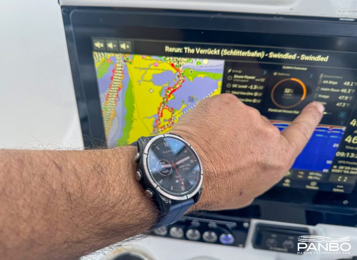
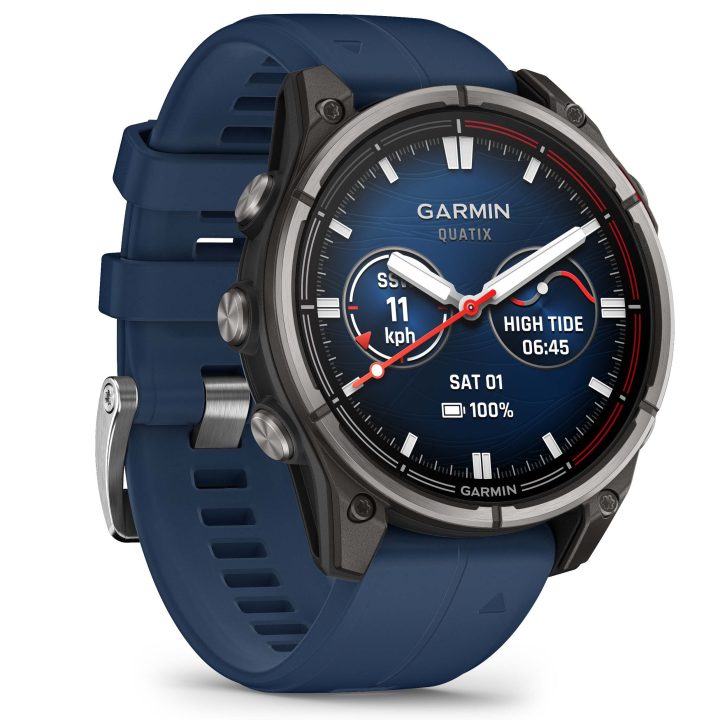
Panbo

Category: Handheld

Wind Meter app, & iPod Touch bluetooth

Jun 18, 2009
Wind_Meter_app_cPanbo.JPG

iPhone folks will notice that the one I'm holding above is upside down.  That's because the Wind Meter app shown uses the sound of wind passing over the iPhone's microphone to measure its speed.  And -- would you believe it? -- it actually works.  I was out testing and photographing the NMEA 2000 wind rig early this morning and thus could compare Wind Meter to a consensus of five high quality sensors mounted just a few feet over my head.  No, it's not as accurate or responsive as they are (especially flaky under 3 knots or so), and it apparently can't handle speeds over about 25 knots, but still...

Continue Reading

iPhone mania, a marine app slide show

Jun 10, 2009
iPhone_marine_apps_cPanbo.JPGSo there's a new iPhone, the 3G S, and some of its new features -- like a built-in compass, voice commands/feedback, and a much faster processor -- will no doubt benefit marine navigation applications.  But I've been trying the major existing apps (thanks to a loaner 3G from Navionics), and can tell you that they're pretty seductive as is.  None is perfect by any means but the three above -- Navionics' Mobile Gold, GPSNavX's iNavX, and Navimatics' Charts & Tides -- each has some interesting features.  And I've assembled a super duper screen shot slide show to illustrate...

Continue Reading

iPhone/Touch nav, yet more news

May 20, 2009
Navionics_Mobile_2_sale_cPanbo.JPG

I don't usually write about rebates and sales, but 90% off!?!  Navionics not only launched version 2.0 of its Mobile app yesterday, it's slashing prices. Here's the press release, and note above how the whole Gold USA East chart portfolio dropped from $50 to $5.  Apparently all the chart region prices will follow -- at least to some degree (British Columbia now $10) -- in the next few days, and stay bargain priced for "a limited time this summer."  A month ago I noted how fast iPhone/Touch navigation is moving, and it hasn't slowed down...

Continue Reading

Fugawi & iNavX & Navionics & ??, the pieces come together

Apr 15, 2009
iNavX new chart n map choices2.jpg

Wow, isn't an interesting crowd of chart, map, and data suppliers gathering rapidly around the iPhone/multi-other-platform X-Traverse service?  I recently discussed the velocity of this and other iPhone-related developements, but was still surprised to learn today that Navionics is officially on board (Americas charts and U.S. Hotmaps available now, the rest of the world portfolio coming "in the next couple weeks"), that Hilton's Realtime-Navigator fishing overlays will go up on X-Traverse in May, and that "agreements are in place with several other chart manufacturers to bring expanded coverage and choice (raster or vector)."

Continue Reading

iPhone nav, forward in many directions

Mar 19, 2009
Thumbnail image for MotionX_iPhone.jpg

Thanks to the April editon of Sailing World, I now know about the interesting and nearly free iPhone app MotionX-GPS. It's more a GPS than a plotter, and not specific to boating, but, as you can see above, it's got some boating fans. MotionX purportedly uses the iPhone's accelerometers to improve GPS performance, it supports open source mapping, and it was developed by a company founded by well known competitive sailor/geek Philippe Kahn. Unfortunately I can't try it on my iPod Touch because the it has no internal GPS, and no way to attach one (darn you, Apple!). But there are some iPhone marine apps I am trying, or will soon...

Continue Reading

Lowrance Endura handhelds, open source?

Jan 30, 2009

Lowrance Endura Outback top

Lowrance just announced a new line of Endura touch-screen handheld GPS plotters that look like they’ll give Garmin some competition in this niche. Of particular interest, I think, is this line in the description of the Outlook model shown (it’s the base model, expected to retail at $229 when it ships in May): “Add shared web community content including routes/trails, POI’s, elevation data, etc. in GPX format through drag-and-drop to the device”…

Continue Reading

Garmin nüvi 500 & GPSMap 640, yipe!

Oct 14, 2008

Garmin_nuvi_500_marine_screen

How behind is Panbo? Well, in July I whined about Garmin’s introduction of the touchscreen Oregon handheld before I’d yet written much about the somewhat similar Colorado. While I’ve been testing an Oregon for some weeks (and still haven’t posted here about it), Garmin has introduced two new handheld/portable units of considerable interest to boaters. One is the nüvi 500 above, a waterproof, multi-mode version of Garmin’s 3.5” touchscreen automobile navigator. Which makes it a direct, and probably awesome, competitor to the Lowrance XOG and Magellan Crossover. Fortunately, the able blogsters at GPS Magazine and GPSTracklog have both reviewed the unit, though neither went boating with one. I don’t think anyone has yet seen the intriguing GPSMap 640…

Continue Reading

SailClever? Sure looks it.

Aug 15, 2008

SailClever_current_leg_screen2SailClever is a new kid in the sailboat racing tactical software niche, and it looks clever indeed. According to the developers, the Windows Mobile PDA screen at right “shows one of the main screens you would use while racing.  It has an arrow to show where the mark is, a pointer to show the direction of current relative to the boat, navigational numbers along the top and then a bar along the bottom that shows what side of the beat you are on and your tacking angle (Downwind it shows gybe angles and reaching it shows cross track error).  Pressing the menu button allows you quickly access a number of other screens that give you information on your speed relative to your polars, what the next leg is, what sail you should be using, wind direction and a basic chart.”
   The SailClever software will do a lot more than that, as well illustrated on its web demo pages. It can purchased alone or with a neat-looking Datasoft RS-232 Bluetooth dongle for connecting to NMEA 0183 ports wirelessly. SailClever also offers an extremely rugged TDS Nomad PDA that’s probably way out of your price range, but do enjoy the stress test video. SailClever claims compatibility with several instrument systems—sometimes two-way, as with TackTick—which distinguishes it from the higher end Ockam Eye PDA software, I think. But note that a few of its features are available in iNavX (don’t miss Gram’s latest), Memory Map, and probably some other PDA/Smart-phone apps you’ll tell me about.

From Colorado to Oregon, Garmin never sleeps

Jul 10, 2008

Garmin400c Camden cPanbo

I’ve been meaning to post this photo, bigger here, for a while, as indicated by the snow in the background! It shows how the Garmin Colorado 400c screen—despite the somewhat anemic back-lighting I once bitched about—looks Garmin rock_n_rollerquite good in direct sunlight. I was also going to write a bit more about the big “Rock 'N' Roller thumb wheel/cursor thingy” that’s both quite an interesting technology (the control signals are transmitted magnetically through a waterproof shield), and the doorway to an interface I’ve come to like quite a lot. But, dang, Garmin has just announced yet another marine handheld, the similarly powerful Oregon 400c.

Continue Reading

AIO PNDs, and writing

Jun 2, 2008

AIO_PNDs_in_Camden_cPanbo

If Mae West were alive, her famously bawdy trademark line might go like this: "Hello there, sailor. Is that a WAAS GPS AIO PND loaded with a continent's worth of nautical, street, topo, and photo cartography and several hundred thousand POIs in your pocket...or are you just happy to see me?" To which a sorry geek like me might squeak back, "Pardon, Ms. West, no time for flirting; I've got gadgets to fiddle with!" Indeed I do.

So goes the opening paragraph of my current PMY column, Pocket Navigation, and I’m hoping it will make you chuckle, and read on. Plus you might enjoy a high res version of the alternate lead photo above, and looking back at first Panbo impressions of the Garmin Colorado 400C, the Magellan Crossover, the Lowrance XOG, and the DeLorme PN-20.

Continue Reading

Crazy Lenny "stress test", and a Mad widget

Apr 30, 2008

GPS_VHF_HANDHELD_STRESS_TEST_Lenny_Rudow_MadMariner

“I chastised the children for their lack of destructive ambition, handed out sticks and suggested they use the handhelds as drums, instead. They started whacking away.” Lenny Rudow’s Handheld Stress Test, published yesterday on Mad Mariner, has to be one of the funniest electronics articles ever. Plus it’s good to know what abuse these Garmin, Lowrance, Raymarine, and Uniden GPS and VHF units can take. They all survived the kids and even the flush test. I’ve always appreciated Lenny’s work—which runs from fishing to electronics—and enjoyed getting to know him when we played judges together in Miami…but had no idea how creatively destructive he could be.

Continue Reading

SPOT share pages, in beta

Apr 28, 2008

Spot_sharing_example_cPanbo

The SPOT satellite messenger is about to get more attractive to many boaters. Originally it wasn’t all that easy to share your tracking with friends and family; in fact, to do so you had to share your entire Spot account user name and password. But now Spot is beta testing a pretty sophisticated feature that enables Web sharing of both tracks and messages. Above, and bigger here, is a zoom of a shared page I recorded over the weekend; every 10 minute tracking isn’t perfect for driving, but #14 is the exact parking spot I occupied at Rankin’s, my favorite hardware store.

Continue Reading

Lowrance XOG, first impressions

Apr 15, 2008

Lowrance_XOG_Virginia_cPanbo

I’ve actually been testing Lowrance’s XOG for months now, and have become quite a fan. Primarily it’s a touch screen car navigator with voice directions and two gigs worth of Navteq street maps (U.S. and Canada) and three plus million POI’s built-in. But it’s also splash proof and can display all sorts of Lowrance and Navionics cartography on preprogrammed SD cards, or downloaded to your own card from www.map-select.com. What you’re seeing above, and bigger here, is an older Navionics Silver card.

Continue Reading

Speeding w/ Simrad, tracking w/ Garmin

Mar 31, 2008

Simrad_demo_boat_Miami08_cPanbo

That’s me in the tan shirt, aboard the 34’ Yellowfin (run by pro Mark Maus) that Simrad used in Miami to show off its new GB40 and NX systems. I’d already covered their introduction in PMY, here and here, but still have a lot to learn about their details. The demo trip wasn’t a particularly good environment for studying details, but I did learn that both can keep up a pretty good plot even at 63 MPH! Eventually I’ll write more about the monster install in that center console, but today I want to discuss tracking that personal-fastest-ever boat ride with the test Garmin Colorado that was in my bag.

Continue Reading

PN-20 vs Colorado, handhelds on ice

Feb 4, 2008

DeLorme PN-20 n Garmin Colorado cPanbo

I’ve had a Garmin Colorado here for a week or so, and while there’s a lot to like about it, screen brightness is disappointing (especially given Garmin’s recent fixed plotters). Here it is alongside the DeLorme PN-20 out on Lake Megunticook near dusk this afternoon, bigger photo here, with both screens turned up to maximum brightness. Note however that the DeLorme may have the brightest color screen I’ve ever seen on a handheld, though it’s also pretty small, particularly compared to the Colorado. By the way, despite all the maps, charts, and photos each of these devices can display, I don’t think there is an electronic navigation ‘chart’ available for Megunticook in any format. Lakes are funny that way…i.e. there is no Government agency tasked with mapping them all. More on both handhelds eventually. Oh, and what was I doing out there on the ice? Well, we lost all our snow in a few rain storms, and so I’ve been learning how to use a pair of 21” Nordic cruising skates. They’re great!

Garmin Nuvifone, the gPhone?

Jan 30, 2008

Garmin Nuvifone

Lusting after what looks like a breakthrough cell phone, Internet tablet, video/still camera, and PND (personal navigation device) is way more fun than fretting over FCC frustrations. Garmin surprised a lot of us when it introduced the Nuvifone in NYC this evening. Sure, it looks like an iPhone but the early info suggests that it has even more going for it, especially the GPS/navigation part, but also a tight Google relationship and fast 3.5G GSM cell data. 

Continue Reading

DeLorme PN-20, first &$?!ing look

Jan 23, 2008

DeLorme_PN20_chart_cPanbo

Sure, I’m a dite (or tad, dab, etc.) biased toward companies from Maine. I’d be excited about ActiveCaptain no matter where it was, but knowing that it’s home-based right across the Bay likely juices my enthusiasm a few percentile (and maybe the reverse bias is why my Navagear buds seem so oddly tepid on AC?). At any rate, it’s with some sadness that I’m about to skewer DeLorme, even though it’s not only very Maine but also built the world’s largest globe here. How cool is that? So I was pretty intrigued when I realized that the company’s first handheld, the Earthmate PN-20, was also the first ever (I’m pretty sure) to show NOAA raster charts. It’s also one of the first to show multiple cartography types and to let you purchase just what you need, when you need, on the Web. We’re going to see a lot of that model, and I think it has potential merits.

Continue Reading

Garmin Colorado, next gen handheld?

Jan 4, 2008

Garmin_Colorado_crop2

Last night Garmin announced a slew of new mobile products, and I must say: WOW! Check out the Colorado, a high-end handheld designed for driving, hiking, boating, and…um…multimedia, location-aware, gaming/educational experiences! The interface is neither old Garmin handheld nor new Garmin marine, instead featuring that big 'Rock 'N' Roller' thumb wheel/cursor thingy, and two soft keys. The wheel brings up a spinning menu system (seen right) that’s a bit like Furuno’s RotoKey.

Continue Reading

Amerigo mobile nav, open source

Sep 14, 2007

Amerigo

Head’s up, open source programmers. Marcello Ferrero has begun the Amerigo project, navigation freeware meant for PC, PocketPC and WinMobile phones and PDAs. A “PreAlpha” release is out, and Ferrero is hoping some nautical code jockies will join him. One feature that he thinks unique will be the ability to use a Smart Phone with camera to create a photo POI in one click, adding categories and text as desired. But I wouldn’t be surprised to see this sort of feature arrive first from ActiveCaptain’s mobile project, still “under construction”, or maybe EarthNC, or who knows where. Does anyone doubt that Web 2.0 will mash up tight with marine navigation eventually? 

Outdoor Navigator becomes Activemap, and free

Dec 9, 2005

Activemap

NOAA’s free chart policy strikes again! Maptech will no longer sell  Outdoor Navigator, the nifty PDA (both PocketPC and Palm) and Smartphone charting program sort of shown above. The developer, Jeffrey Siegel, has decided to go independent, largely because he can now freely access U.S. raster charts and topo maps. Moreover, the program, to be called activemap, will also be free. I don’t quite understand the business plan, if there is one, but am quite sure that Jeff and his team are up to something interesting. More as available.

Garmin 376C, holy mackerel!

Nov 9, 2005

Garmin376c Weather

I would have posted earlier today, except that fooling with this Garmin 376C vividly reminded me (above, and bigger here) that the spell of dry, sunny weather was about to end. So I spent some hours winterizing the fleet, all the while watching the clouds thicken up from below and above. I could also see an animation of all that rain moving across New York state, plus the lightning strikes, the frontal lines, pressure gradients, wind predictions, buoy reports, etc. etc. It is phenomenal how well you can see all this info on the 376’s little screen. The display itself is exceptionally bright and detailed, and Garmin has also done a good job at letting you view the weather data mixed together or one element at a time. And, get this, I was also listening to XM radio (below). I’ve been trying the 376C intermittently over the last month or so, and am very, very impressed. It really makes sense in terms of carrying your XM weather and audio subscriptions with you on land or sea. The only con I can think of is that BlueCharts have gotten pretty expensive relative to the competition, but maybe that will change.

The Garmin 276C was one of my 5 Sail magazine “editor’s picks” for innovative, important marine electronics introduced last year. I’m working on my 2005 picks right now, and the 376C is definitely a contender. If you have suggestions for other hardware or software that should be on the list, please let me know.

Garmin376c xm audio

Sail performance software, free

Jul 13, 2005

GPSactionreplay

Above is output from a free program developed in France called GPSActionRelay. It is written in Java, and will suppossedly run on any operating system. Features include replay of several boats in a regatta, polar diagrams, VMG, speed averages, etc. It looks pretty complicated but apparently is used by some sailing teams and a number of geeky windsurfers. I’d like to know what hardware they carry on their boards at 46.7 knots (yi!), but couldn’t find any information. A Garmin wearable Forerunner perhaps? And if so couldn’t heart rate be graphed to speed?

Maptech Outdoor Navigator

Apr 21, 2005

SMT5600Heck, let’s make this Jeffrey Siegel day at Panbo. You see what I didn’t mention below is that Siegel is also the developer of Maptech’s Outdoor Navigator, an excellent PDA (Palm and PPC) charting program that I wrote about back in early 2002 and which has recently evolved in very interesting ways. I thought it was a pretty good deal at $100 with a year access to all the U.S. charts or topos you wanted to download, but now ON costs a mere $20 and you can keep downloading maps as long as you own the PDA it’s registered to. ON also now works on "Smartphones" using Microsoft's cell operating system. The phones from Audiovox, Motorola, and others do not have touch screens, so all ON's controls have been neatly moved to the keypad. Jeff, who naturally is cruising with all versions of his creation, notes that the lack of a touchscreen is one reason why his smartphone has an extra long battery life. He also notes how useful ON is just as a chart reference tool, no messing with a GPS, especially as Maptech corrects the charts on their servers every month.  The whole ON story is here.

AquaFix PLB + SarSat = fast rescue

Apr 18, 2005

ACR AquaFix2ACR sent out a press alert about the first rescue credited to its relatively new GPS equipped Personal Locator Beacon. I can’t find any other Web references to the incident, which involved a pair of divers off Bradenton, Florida, but it certainly sounds like ACR and the whole SARSAT system have something to brag about. The little beacon was set off “around 7pm”, seen by a GOES Satellite at 6:58pm, sent up a GPS fix at 7:01pm (presumably from a cold start), and a Coast Guard 41 footer had steamed 10 plus miles to the scene by 8:10pm. It wasn’t until 7:47 that the LEOSAR satellites could resolve the beacon’s location by the standard Doppler method, a delay that might have cost a life in this case. Hat’s off to ACR’s apparently speedy GPS PLB technology and to the fast SARSAT dispatch system!  Here’s an article I wrote about SARSAT last year, ACR’s AquaFix site, and an early look at these units by Doug Ritter at the Equipped to Survive Foundation (which will hopefully conduct a thorough test of current PLBs soon).

Node Explorer

Oct 2, 2004

Truly ruggedized PDA with lots of features you would like to see in such a device when using it aboard a ship.

"A company in UK called Node has developed the world's first consumer PDA designed for use specifically in outdoor environments. The device is fully waterproof to 3 meters, has a 8 hour battery life, built in DGPS receiver and 1 Gig of storage. Bluetooth and WiFi come as standard as does a touch screen and either a PocketPC or Linux operating system. I bumped into them at a tourism conference in Edinburgh where they were demo'ing the unit and I was impressed. It's smaller than a standard postcard."

Yme Bosma | Permalink | Comments (0)

B&G's RemoteVision

Jul 6, 2004

IBI News reports that B&G will demonstrate its RemoteVision wireless autopilot/instrument control system at the Southampton International Boat Show in September. Can't find anything about it, except for a short quote from Conrad Humphreys, who will be skippering HELLOMOTO during the Vendée Globe.

"RemoteVision is smaller than a palm PC and features a full LCD graphical screen and simple four-button control. It utilises wireless technology to instantly send and receive signals from B&G's h2000 Hercules and Hydra pilots and instruments. All readings from the instruments can be viewed on the RemoteVision anywhere on a vessel, "be it at the top of a 60ft mast in torrential weather or down in the galley preparing a meal," said the company."

Yme Bosma | Permalink | Comments (0)

Ocean Ready Electronics

Jul 2, 2004

Motor Boating Magazine takes a look at one of the ships participating in the Nordhavn Atlantic Rally, a high-seas adventure from Ft. Lauderdale, Fla., to Gibraltar. There's a lot of electronics stuff on board this ship... Here are some of the highlights:

-“It’s the autopilot that’s the most important thing,” he says. And for autopilots, Kinney selected two Furuno NavPilot 500s and added a SC 60 GPS satellite compass."
-"The first display supports Furuno’s 1953C chartplotter with a powerful 12-kW radar for 72-mile range and 1.2-degree horizontal beam width for accurate target separation."
-"The second chartplotter, an 1833C, uses a smaller radar with dome antenna that will pump out 4-kW of power for a range of about 36 miles"
-"Called NT-Link, this is a little sister to C-MAP’s rugged commercial product, only it’s coupled with the NT recreational cartography. One notable feature of NT-Link is its ability to handle online chart updates."
-"But the real heart of the navigation package is Furuno’s NavNet system, which allows for multiple sensor displays on three different display screens—the two 10.4" monitors in the pilothouse and an additional 7" remote display on the bridge."

Yme Bosma | Permalink | Comments (0)

The Early Adopters Of Marine Electronics

Jun 4, 2004

The early adopters of marine electronics can be found in the competitive fishing scene. Here's a story on a guy who outfitted his boat to the fullest extend. Like the article says: "he'll be at the helm of a boat with a control panel that resembles the Starship Enterprise"

"An impressive array of electronics -- everything from a laptop computer and wireless monitors to color sonar, a Lowrance LCX-104C, and global positioning system technology -- covers the dashboard of Samson's 20-foot Crestliner walleye fishing machine. As technological trappings go, not even Mr. Spock or Capt. Kirk could claim bragging rights over Samson."

Yme Bosma | Permalink | Comments (0)

First Wireless Fish Finder Wrist Watch

May 20, 2004

Humminbird's SmartCast Fish Finder Watch has been out for a while, and I've written about it before. But here is another link to it since a new weblog called Wrist Dreams has found out about it as well. They also highlight some other watches for marine use.

"The sensor reads water depth up to 100' with a 90° sonar beam to find the sport where fish hide. All controls are operated from the one-touch wrist unit, including the fish proximity alarm, sensitivity level, depth range, and fish identifier. The remote sensor provides 400 hours of continuous usage, and automatically shuts off after it is removed from water to conserve battery life."
(Humminbird's Smartcast at Amazon.com)

Yme Bosma | Permalink | Comments (0)

Storm Hawk from WeatherData

Apr 26, 2004

A new solution from WeatherData for those of you who prefer to sail the coastal waters, since it won't work if you are to far away from land... Apparently they have some special marine features as well, but it was originally developed with land based applications in mind.

"Special features will be available for marine use including marine charts for the U.S. and surrounding coastal waters, and reports on wave height, buoy observations, high surf advisories and tide data tables. A future version of Storm Hawk will also offer predicted radar that includes the location of storms ten to 30 minutes into the future and will provide the location and prediction of cloud-to-ground lightning with up to 97 percent accuracy, a WeatherData exclusive service."

Yme Bosma | Permalink | Comments (0)

The Garmin Marine Network: How Not To Get Lost At Sea

Apr 16, 2004

Engadget discusses Garmin's new plug-and-play systems (GPSMAP 3010C & 3006C) that put GPS, weather, sonar, radar, and other important data at boaters’ fingertips. It also highlights Garmin's proprietary Marine Network, yet another alternative to NMEA 2000, the standard that somehow takes a long time to mature. One of the advantages of the Garmin approach is that it uses ethernet as a backbone. Since ethernet cables can be used for powering devices as well, this will make a supposedly plug and play boat network a lot less complicated in terms of wiring...

"From Garmin, a couple of new waterproof GPS handhelds designed specifically for seafarers. The GPSMAP 3010C (pictured above) has a 10.4-inch color LCD screen, while the GPSMAP 3006C has a smaller 6.4-inch screen. Both of them work with the Garmin Marine Network, Garmin's new line of peripherals that you can attach to the handhelds. The first two to be available will be the GDL 30, which connects to XM's satellite weather service and can download real-time graphical weather data (there's another version, the GDL 30A, if you want to tune into satellite radio, too), and the the GSD 20, for adding sonar. A marine radar attachment should be ready sometime next year."

Yme Bosma | Permalink | Comments (0)

Rugged Hardware With A Navy Touch

Apr 16, 2004

Through Naval Technology I found some interesting rugged hardware. Some of the highlights:

This one looks like it could have been a good case modding project from a navy adept. But the specs will show that, if you require a PC on board, this one is built for it. It can be shock mounted and is sort of mobile as well...

Israeli BES System's "RCS-PC, and Mini RCS-PCs are rugged PC compatible computers specially designed and qualified for use in harsh Naval, Airborne and Ground mobile military environment. RCS-PC is built for full size ISA and/or PCI cards."

Miltope's Centrino laptop doesn't require a laptop bag, for that reason alone I've listed it here. Although not submersible like Itronix GoBook MAX, it's easy to carry around and definitely looks tough.

"The Miltope TSC-750M, featuring the new Intel® CentrinoTM Mobile Technology is the most versatile and compact rugged-militarized laptop computer available today. Designed and manufactured in the USA, the TSC-750M has been successfully qualified to MIL-STD-810/461/464. The TSC-750M also delivers the fastest-yet 3D video thanks to its ATI MOBILITYTM RADEONTM 9000 graphics accelerator – dramatically enhancing all aspects of the visual experience in every application."

My personal favorite is the GDC4S Mission Data Tool (MDT). It is a ruggedized PDA with a 400MHz Xscale Processor, BlueTooth, GPS and embedded radio interface. But the MDT's looks and form factor somehow really caught me.

"Mission Data Tool (MDT) - The Mission Data Tool (MDT), the latest product in the CHS-2 arsenal of rugged computing devices. The MDT is a ruggedized PDA that hosts Pocket PC 2002 as an operating system. Additionally, it can support a customer-ported LINUX environment. The MDT has been engineered to survive the rigors of the tactical battlefield, and has incorporated extensive soldier feedback into its design. The resulting product is a computing device that will be readily accepted by the deployed warfighter and homeland defenders."

Yme Bosma | Permalink | Comments (0)

Wireless TV On Board

Apr 13, 2004

Nowadays wireless LCD TVs still have a few disadvantages, but on a boat they could provide more flexibility when it comes to entertainment. Plug all your video sources (DVD, STB, aerial) in the base station, and use your wireless display everywhere. Its range of 50ft should be perfect for on board viewing, wether on deck or in a cabin. Let's just hope battery live will improve rapidly.

"When the signal is solid, the picture is terrific, with a wide viewing angle, high contrast and defined images characteristic of Sharp's outstanding approach to LCD (viewing on the sun deck at high noon isn't recommended, though). The issue is whether cable-free living and potentially dicey performance is worth twice the price of a wired 15-inch LCD TV."

Yme Bosma | Permalink | Comments (0)

Uniden's VHF/GPS Mapping Marine Radio

Apr 12, 2004

Great to see that more and more marine electronics and communications functions are being integrated. Not only on a hardware level, but definitely also on a software level. What I really like about Uniden's MYSTIC, a full VHF/GPS Mapping Marine Radio, are simple functions like having a buddy list. Product design that starts with user needs is something we don't see often enough.

"Uniden is making an emphatic comeback with its new Mystic, a strikingly original and well-executed marriage of a full-on Magellan hand-held WAAS-GPS plotter and the first portable DSC-VHF radio with advanced functions like buddy lists. The two work together, plotting the origin point of incoming DSC calls and including your position with your outgoing calls (for fun or in distress). In my testing, the submersible unit demonstrated long battery life and solid performance. It comes with U.S. street and buoy maps and supports Magellan's full-detail BlueNav charts. The Mystic, which is 13" tall and lists for $699, is not a trivial gizmo to clip on your belt, but -wow!- is it capable."

Yme Bosma | Permalink | Comments (0)

A Complete Wireless Anchoring Experience

Mar 19, 2004

A couple of weeks a go I mentioned Ascend Marine's Deep Blue Marine's Anchor Alert, a wireless anchor monitoring system. To make the anchoring experience completely wireless (except for the anchor chain...), I got a tip from Carl Midson on Coastline Technology's Windlass Radio Remote. Carl claims it's brilliant if your shorthanded on board, so check out this review in Power & Motoryacht.

"Sometimes it’s easy to inadvertently activate foredeck-mounted windlass footswitches, and cabled remotes can restrict movement around the area and often need to be passed up through a hatch, which is inconvenient at best and can be dangerous under harsh conditions. The Windlass Radio Remote allows you to control your windlass from anywhere on your boat, no matter what you’re doing and regardless of the conditions."

Yme Bosma | Permalink | Comments (0)

Rugged Cellphones

Mar 19, 2004

When I was going through the log-files of this website I noticed that many people come here searching for rugged cellphones. Fortunately, Siemens unveiled the ruggedised M65 this week. Not sure if it's really rugged up to the level you would require in a marine environment, but it is a start.

"The splash, dirt and shock resistant M65 sports a 2.1in 132 x 176, 16-bit colour display, backed by a 640 x 480 digicam for video and still photography. Stills can be edited using on-board software, with special effects filters built in too. The handset supports 40-voice polyphonic ringtones, a customisable user interface, Java games - four titles are bundled with the phone - and instant messaging. The tri-band GSM/GPRS handset comes with a 750mAh lithium ion battery - enough, said Siemens, for five-and-a-half hours' talk time and 300 hours' standby time."

Yme Bosma | Permalink | Comments (0)

Bluetooth GPS Receivers

Mar 17, 2004

Since I was discussing Bluetooth-enabled devices already, here is a round-up of different Bluetooth GPS receivers currently available. Although the review is focused on the use of these devices together with PDA's with streetmap software installed, they are compliant with NMEA standards. This means they will work with your Pocket PC navigation software as well. Just beware of the fact that they are not necessarily ready for use in a (harsh) maritime environment.

There is definitely a benefit in using this type of solution over using something like Mitac's Pocket PC with integrated GPS: "The major benefit of a Bluetooth-enabled GPS receiver is that it doesn’t have to be physically connected to the Pocket PC. That eliminates a tangle of cables that dangle in your way while you are walking or driving. In addition, Bluetooth solutions let you position the GPS receiver for optimal GPS reception, and your Pocket PC separately for the best viewing. Bluetooth can travel around corners, and through clothing and other material."

Yme Bosma | Permalink | Comments (0)

Cellphone centric navigation

Mar 17, 2004

I've talked about the potential of radar and navigation capabilities on cellphones before, but in Japan it is already happening. Although currently meant for navigation in a city environment, it's a perfect example of how cellphones are becoming powerful enough to perform such functions. Combine that with the fact that both cellphones and marine instruments are becoming more and more Bluetooth-enabled, so they can communicate wirelessly, and you will realize that we don't need a dedicated navigation-PC anymore.... Just the monitor.

"Japanese firms Index and Jicoux have developed a navigation system application that runs on 3G GPS phones with digital compasses (which, at the moment, means KDDI's au service in Japan). It includes the ability to show a "radar display" of the location of nearby friends, places of interest, or bus and train stations useful in getting to your destination. There's also a B2B aspect to the service in that, as with most web-based map systems, it would be possible to pay to have your business location displayed on the radar."

Yme Bosma | Permalink | Comments (0)

A Very Mobile Radio

Mar 16, 2004

Definitely not the most inspiring gadget I have ever seen, but at a price of $20 I'm sure there are people that will see this 'very mobile radio' device and conclude that this is exactly what they were looking for....

"Smaller than the size of your palm, the CapRadio fits on the back of your cap, on your shoulder or on the collar of your shirt. The reception is about the same as any Walkman - obviously don't take it for lengthy offshore trips - but at the dock or floating around the bay you should be fine. When you walk, it doesn't jostle, and the tight-fit clip keeps it nice and snug up against your hat."

Yme Bosma | Permalink | Comments (0)

Got the whole world­ - in my hand

Mar 10, 2004

Boatsandplaces.com did a review of NDI's Pocket PC solution for handling electronic charts. They're pretty happy with it, a bit to their own surprise. Now combine this with Mitac's Pocket PC we saw yesterday which features integrated GPS and there you have a perfect solution.

"Chart plotters and computer software for e-charts are old news. What could possibly be new and startling in this field? How about a hand-held Personal Data Assistant ­PDA ­showing full raster charts with software that gives you all the features of a laptop?"

Yme Bosma | Permalink | Comments (0)

Pocket PC with integrated GPS

Mar 9, 2004

The world's first combined PocketPC with GPS is launched by Mitac. PDA Buyersguide has done an extensive review of the Mitac Mio 168.

"Palm OS users who wanted an integrated GPS had their prayers answered by the Garmin iQUE 3600 in 2003. Pocket PC users now have the Mitac Mio 168, introduced March 2004, as their all-in-one solution."

Yme Bosma | Permalink | Comments (0)

Keep your eye open

Mar 4, 2004

Performance racing goes hand-in-hand with wireless communications. Ockham, a leading provider of instruments and software, introduced a PocketPC version of their software, which communicates with other instruments using Wi-Fi.

"Cost effective wireless instrument information and system control - Ockam
introduces OS4 EYE. Load Eye software on your PDA (Pocket PC) and your
Ockam connected WiFi PC. View multiple pages of instrument data, set cals,
averaging and controller functions, track trends on stripcharts, all in
your pocket. - hiking hard on the rail or monitoring performance from your
bunk!"

Yme Bosma | Permalink | Comments (0)

Wi-Fi PDA's

Mar 3, 2004

If you're thinking about using a Pocket PC on board that will connect wirelessly to other systems via Wi-Fi, have a look at this review over at ZDNet.

"Last year saw wireless tech's profile take a major jump. Hot spots popped up all over, and more and more Wi-Fi products hit the market. Want to score a Wi-Fi handheld that scored high with our editors? Here are five we love."

Yme Bosma | Permalink | Comments (0)

Radar on a tiny silicon chip

Feb 26, 2004

All the basic building blocks of the radar system fully integrated on one chip, including power generation, signal processing, and dozens of other functions? This would save a lot of precious space on ships that require a radar, and it has some other advantages as well. Update: for more information have a look at the Slashdot discussion on this topic.

"Now a team of electrical engineers at the California Institute of Technology has shrunk the functions of a radar system into one tiny, intricately designed silicon chip and eight minuscule antennas.

"Using these extremely high frequencies, you can first capture location, sending out pulses and scanning the area like a bat," said Volkan Ozguz, chief scientist at Irvine Sensors in Costa Mesa, Calif. Irvine Sensors makes miniature electronic systems, including sensors. "Then, using the same chipset, you can start communicating at high frequency," exchanging information without switching to different equipment, he said.

"It should cost no more than a few dollars," he said."

Yme Bosma | Permalink | Comments (0)

The Joys and Sorrows of PDA Plotters

Feb 19, 2004

PDA's are becoming a very useful tool for sailors, primarily for navigation purposes. With advancements is battery life, wireless connectivity and software stability, the future for device devices in a yachting context looks very bright.

"Thus the pieces came together for PDA plotting, and in 2001 Maptech introduced Pocket Navigator, the program I've been running on an iPaq equipped with a Navman GPS sleeve. It's a slick package. Before a trip, I boot up the software's PC module and select the raster charts and topos I want, build routes if needed, and download everything to the handheld's memory card. Once I'm outdoors or have the iPaq mounted to my boat or car windshield, the GPS acquires position, and the magic begins. Friends looking over my shoulder, particularly ones familiar with regular plotters and/or PC charting, are invariably astounded at how sharp the charts look, how fast they zoom using the control keys, and how smoothly they pan when dragged with a stylus pen or one's fingertip."

Yme Bosma | Permalink | Comments (0)

Wireless displays have a bright future in yachting

Feb 16, 2004

Wireless displays, not Tablet PC's which are PC in themselves, will definitely have benefits when used while sailing. They will easily decouple the display from a computer that is used for navigation and all other kinds of purposes. Especially when they are water-resistant they should allure to sailors and Panasonic Toughbook MDWD Wireless Monitor is a good example.

"While not specifically designed for boats, this innovative addition to the Toughbook line will interest navigators who want flexible access to a yacht’s PC system. It weighs only 1.5 pounds, and its 8.4-inch, 800x600 pixel, color touchscreen LCD is both transflective and powerfully backlit."

Yme Bosma | Permalink | Comments (1)

Wireless sailing

Feb 4, 2004

Sailing World is running an article on how wires are being obsoleted by some interesting wireless technology developments. This could save cost and improve sailing performance at the same time.

"Is it far-fetched fantasy? Nope, we're talking here and now. With advances in wireless technology driven by worldwide market demand, racers can either equip their boat with a complete wireless system or upgrade existing instrument systems for wireless data retrieval and display. Wireless technology will allow racers to shave weight all over the boat. There may even be cost savings in boat construction, as boatbuilders will no longer have to spend precious time leading wires."

Yme Bosma | Permalink | Comments (0)