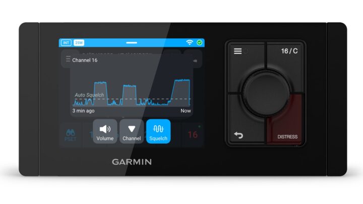
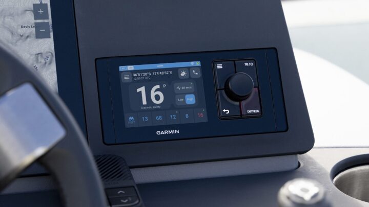
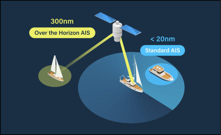
Should I rename the blog iPanbo? I know I've been focused on these marine apps a lot, but, as noted just last week, the developement velocity is awesome. I first heard about Ship Plotter this morning from the good gCaptain, who is working on a similar app (with more of a professional slant, natch), and judging from Ship Finder's web page, I didn't even think it was Apple approved yet. But I learned otherwise when the enthusiastic developer showed up here, had copies running on iPhone and Touch in minutes, and, wow, it's good. This, mind you, is not AIS as presented on iNavX, which functions like a little plotter; this is AIS web style, collected from multiple shore receivers, plotted on Google maps, and often annotated with much more info than what is actually sent over the AIS system. I hadn't realized how usefully these "live" AIS feeds could work with an iPhone's display power, portability and always-on internet connection...
Yesterday I fired up this sample Simrad AI50 Class B AIS transponder and found it to be pretty much as self-contained and impressive as I'd hoped. I attached one of my boat's VHF antennas, deployed the AI50's included GPS antenna, gave the unit a little 12v juice (just 8 watts at 100% screen brightness), and, voila, Gizmo was transmitting its position and plotting other AIS targets, including another Class B I had set up as "Panbo.com Lab". A full AI50 entry will follow, but first I'll report on its SimNet/N2K output. I was excited about how easily NMEA 2000 could feed the AI50's target and GPS info to all devices on the network, but nervous about that how well 2000 currently handles the data (nobody has yet tried it much). Both feelings were justified...
After METS 2007, I wrote about how many new AIS products Comar had in the pipeline. Well, this U.K. company hasn't slowed down, and has even developed a snappy new logo and Web site. Comar's latest is this AIS-Multi, which seems like quite an able AIS listener at $399 (from U.S. distributor Milltech Marine). It features true parallel receivers, so slow Class B updates will plot as well as they can; an amplified VHF splitter, so you don't need to add another antenna; USB data output, so you can connect it to a modern PC without needing a serial converter; and, finally, the ability to multiplex in NMEA 0183 data at 4800 baud (GPS most likely), so the unit's 38,400 baud data output can be easily used with a plotter whose NMEA 0183 port was already in use (and the PC will get it, too). But...
Ever since I realized that the free Siitech.com AIS pro web viewer can count and/or filter AIS types, I've been using it occasionally in an attempt to gauge the spread of Class B in the USA. You may recall the day last October when my Li'l Gizmo was the only Class B to show up on the whole East Coast (or at least within range of a certain mix of listening towers). And, frankly, I haven't seen many B transponders in US waters since then...until today when there were six in the general New York area, almost all underway. And, surprisingly, some were being seen well offshore, in fact way offshore...
Thanks to Sandy Daugherty over on the Forums, I now know that JRC has introduced a VHF radio series that can easily make direct DSC calls to AIS targets. They are most definitely big ship radios (see diagram below), and they do AIS calling in a way I hadn't anticipated, but still...
I wished I'd clicked on one of those AIS targets before I took this screen shot, so you could see how CE 2009 displays their properties, but our focus (after the reboot affair) was on crossing the Boston shipping lanes in pitch dark and with enough true wind on the beam (reported right at the boat icon from the PB 200) to bounce us around a bit and deposit salt on our windows. Thank goodness for AIS. The 277 meter S/S Explorer was lit up like a Walmart super store, and would have been intimidating if we weren't confident that she was anchored or moored. It was also nice to easily speak with the bridge of the Haruna Express and learn that they could see us fine on their AIS display. But the best AIS moment came a little later, when a passenger ship exiting Boston hailed us by name on channel 16 to discuss our passing situation. So what the hell are cruisers talking about when they presume that Class B AIS has little value around big ships?...
In the screen above I was testing Coastal Explorer 2009 with AIS target data coming in from a shore receiver network via an IP feed. It was neat to watch the pilot boat rendezvous with a ship inbound to Narragansett Bay, and it showed off CE's ability, like NavSim's, to dead reckon targets (note how it's using COG, not heading), as well as track them and pop up useful info with a mouse click (or finger tap). But good data and good data presentation like this could be used for very bad purposes. Despite all the discussion of Somali pirates last week, I didn't hear anything about whether or not they use AIS to rendezvous with their targets...but I'm not surprised that they do, and that the crews thus exposed are pretty pissed off about it!
At the Miami Boat Show, NavSim Technology was showing some neat AIS plotting features, and yesterday I got them to send some illustrative screen shots. In the lower right "secondary chart view" above you can see how NavSim uses yellow, green, and red target icons to show moored, moving, and dangerous vessels (a full explanation of AIS icons here, and special Class B icons are coming soon). You can also see how a user can set an AIS Filter Range, which doesn't actually eliminate any targets but does reduce them to dots (sort of like IMO "sleeping" and "active" targets). In the main chart window, you can see what happens if a target's CPA and TCPA violate user set minimums; the Alert pops up along with red and purple "ghost" icons depicting the target and your vessel in the worse case scenario (i.e. at the Time of Closest Point of Approach). And there's more...
If I understand the timing correctly, about when Raymarine starts shipping its new AIS 500 Class B transponder in May, it will also offer software updates for A, C, E, and G Series MFDs that provide some AIS plotting improvements. On top of the list is "buddy tracking", which I consider a valuable feature, though the term -- used by several manufacturers -- is a bit misleading. The idea is that when you see an AIS target that you might see again, and care about -- be it a friend, or a local fishing boat that sometimes seems like it's driven by zombies -- you can save its name and MMSI in a little database kept by your MFD or charting software. Then...
Thanks to an angelic Panbot, I've now read pertinent sections of IEC 62388, a.k.a. "Maritime navigation and radiocommunication equipment and systems -
Shipborne radar - Performance requirements, methods of testing and
required test results." It's a hundred pages (preview PDF here) laying out in great detail the minimum requirements for how all new radars going on SOLAS ships will perform and present data. Perhaps most important among many mandated enhancements is the treatment of AIS targets, Class B included, putting them on essentially the same level of safety value as radar targets. I think these standards are good news not only for the bridge teams on big ships, but also us little guys who sometimes travel amongst them (despite the consternation that came up yesterday)...
Given the new C Series Widescreens and ST70+ displays, and my mid-week absence (moms happen!), let’s just call this Raymarine New Stuff Week. Behold the AIS500, which just may be the easiest-to-integrate-into-your-system Class B transponder yet. That’s because, like Ray’s AIS250 receiver, it has an NMEA 0183 multiplexer and a VHF antenna splitter built right in. Note that splitting 25w VHF and 2w AIS transceivers is more complex than just sharing a VHF with a receiver, and to date only the Digital Yacht SPL250 claims the ability (and seems to work well in my testing). And that’s not all…
My coverage of the NMEA Conference last October was dominated by Class B AIS (and largely—doh!—a vessel naming issue that turned out to be immaterial). But in fact I also learned how AIS is getting into all sorts of marine systems, and was reminded of that by the recently published minutes of the Oct. 3 GMDSS Task Force meeting I attended. One item of note is the prototype AIS SART seen above, overlaid on a slide of the impressive test results such SARTs are generating. Most recreational boaters aren’t familiar with Search and Rescue Transponders, but they are standard gear on ship lifeboats, and heretofore used radar amplification—like a RACON—to help rescuers home in the last few miles. I’ve seen a live demo and wasn’t very impressed, and I’ve even heard buttoned-up GMDSS regulator types complain that it was not a very effective technology. Well, guess what? AIS SARTs work much, much better. The specifications aren’t yet wrapped up, but interestingly AIS SARTs will apparently broadcast just once a minute, but with eight message bursts to compensate for wave interference. Is there lots more AIS may do? You betcha…
Most Class B AIS units have an SRM/Silent Mode switch on their casing, but the ACR Nauticast B instead provides a wire to a user-supplied switch. The plus is that you can more easily mount the transponder remotely, the minus is that you do have to install a switch, or only use the included software to control the functions. Incidently, that same software (similar to this) lets you choose the switch function: either to go in and out of silent (receive only) mode or to send a SRM (Safety Related Message, so far little used). At any rate, longtime Panbo reader Dan Gingras—a known LED fan—built the handsome Nauticast B switch above, and has kindly shared his design…
Just online this morning is the USCG’s latest proposed rulemaking regarding the use of AIS by commercial vessels (and also expansion of the Notice of Arrival and Departure requirements). While the PDF weighs in at 94 pages—and contains some required bureaucratic folderol (that must drive writers nuts)—the suggested regulations make a lot of sense and will significantly improve marine safety, I think. Once refined and enacted—the USCG is hoping for 2010 mandates—the new rules will also be a boon for the manufacturers and installers of Class A or Class B AIS transponders, or both. You see, while the CG has a very specific idea about which formerly-exempt vessels should be made to carry AIS—17,442 more tugs, fishing boats, dredges, passenger vessels and others, to be exact—and endorses Class B technology with vigor, it also recognizes the superior performance of Class A, and is asking all parties involved to help decide which gear should be required on which new classes of mandated vessels…
So far, the best (free) Web AIS coverage I can find for New York Harbor is provided by Vesseltracker.com. Though you have to register to get even a two hour target delay, the site is helping me understand the scene, VHF chatter included, and also illustrates an important point about AIS today. A lot of medium-sized commercial vessels—like all the up-to-150 passenger Water Taxis I see constantly buzzing around lower Manhattan—are not mandated to carry transponders, and don’t. But the U.S. Coast Guard is hot to change those rules, and in fact just issued a draft of the new mandates that I’ll discuss tomorrow. In the meantime. let’s take a closer look at Vesseltracker and its cousins…
I don’t know why Furuno has been quiet about it, but on Nov. 6 the FCC certified its FA-50 Class B AIS transponder (select “AIS” for Equipment Class here). While the product is described at the home site, and is for sale in Europe, it is not yet listed at FurunoUSA. But, as seen above, and bigger here, I’ve been trying one in the lab. And, yes, that is a first-ever-for-transponders Ethernet LAN connection, but there’s a “gotcha” to its use. While you can access the FA-50’s extensive set-up and diagnostic menus with any browser on any computer, you can not get GPS and AIS target info to anything but Furuno NavNet hardware or MaxSea software via Ethernet (also true of the FA-30 receiver, I think). That seems a shame as charting programs like Coastal Explorer and The Capn happily accept Ethernet AIS data (apparently using a format that’s become fairly standardized amongst the Web AIS viewing systems). But the FA-50 does offer conventional NMEA 0183 output, and possibly superior Class B performance…
This old-man-on-a-megayacht shot seems right for my birthday (62!), and also says a lot about what Simrad is up to. The 142’ Richmond Lady sports a passel of Simrad gear, including two GB60 systems with six 19” displays. There’s a lot of detail on this Richmond Yacht page, and you can check out the bigger photo (thanks to Ron Ballanti). Though it’s not online yet, the GB60 will soon be upgraded to the GB65, which will include MAX Pro cartography and support for GRIB files and Navico's Sirius Weather Module (which will pop up in several Navico brands).
Here’s Digital Yacht’s SPL250 VHF antenna splitter, purportedly the only splitter able to handle 2 watt Class B AIS and regular 25w VHF transceivers without smoke rising from either. (That’s supposedly true even if the splitter loses power, though I haven’t yet dared to test that feature.) It will significantly simplify some Class B installations, particularly here in the States where our VHF antennas and radios typically use PL-259 connectors, while most Class B VHF antenna inputs are BNC. That’s exactly how the SPL250 is set up and it even comes with those PL-259 and BNC patch cables. Check out Tim Flanagan’s Shine Micro AIS-BX install for a lesson on the value of a gadget like the SPL250.
We’re down to Class B AIS details, my friends, and they aren’t hard. Above, and bigger here, is the Static data screen seen in the proAIS software that comes with the European version of Digital Yacht’s AIT250 transponder (and possibly others, as it comes from SRT, the manufacturer of so many Class B circuit boards and finished boxes). In the U.S. market this is the screen an installer would see after he or she had entered the vessel’s MMSI number. Users will see all those data fields grayed out (I presume, as I haven’t actually seen the finished U.S. software). Of course that’s because the FCC barred users from inputing the data themselves. But the user does have to supply accurate info to the installer. Let’s break it down:
This weekend I’m working on a PMY column about Class B AIS, and now have three transponders up and running, which you’ll hear about. But I also went over my notes and audio recording of the NMEA AIS meeting, and recalled with a smile Jorge Arroyo’s dismay about repetitive and goofy recreational boat names. “We don’t want 250 Rum Runners in our database!” he exclaimed. The very next day I saw Bullship moored above at Catalina Island. The truth is that we can be pretty foolish about boat names, and they are going to look…um…unprofessional on AIS target screens and Web sites…
A nice thing about Class B AIS transponders, I think, is that by regulation they include a GPS and thus they deliver “own vessel position” along with AIS target info to whatever displays they feed. But that can present an issue if you’re adding Class B to a system that already has an NMEA 0183 or a SeaTalk GPS attached. Brookhouse seems to have a neat multiplexer solution that makes the new GPS a backup ready to automatically take over if the vessel’s regular GPS fails…
Check the stats! They indicate that at one moment earlier today one particular network of AIS coastal receivers was seeing 763 AIS Class A transponders from towers scattered around the U.S. And one Class B. Guess whose 5 meter pleasure (and electronics testing) vessel that was?
Wow, the Class B AIS story is moving fast. If I’m understanding the FCC Equipment Authorization database correctly (select “AIS” from the “Equipment Class” drop-down list), last Friday Navico added one last submission to its NAIS-300 application—the photo above—and the unit was certified that very day, along with the Simrad AI50. The photo, full size here, not only shows a new warning label that’s apparently acceptable to the FCC (remember, it has changed its mind before), but also a Class B transponder I’ve never seen before. So we have two new questions: can an American buy either of these Navico transponders today, and what the heck is a NAIS-300?
The one-day product exhibit at the NMEA Conference is never long enough for me, and I hope the manufacturers I missed—often the ones I know the best—took no offense (you know where to find me!). I put particular focus on companies appearing at NMEA for the first time, like Digital Yacht above. This U.K. firm has been operating in Europe for some time, and is larger and more diversified than even its extensive Web site indicates. For instance, principal Nick Heyes seen above, and bigger here, is also a principal at Marine Electronic Services LTD. At any rate, Digital Yacht is not only setting up a U.S. distribution and service branch, but also introducing an interesting new navigation system called Touch…
What with Class B AIS transponders finally coming to market, a new AIS receiver may seem irrelevant. But it’s from Icom, it seems to be designed and priced right, and I suspect that it will be a winner. The $500 MXA-5000 is a true dual channel receiver—especially important when Class B proliferates—with a built-in antenna splitter, dual outputs (plotter and PC), and the ability to mix GPS input into the AIS target stream. This sample unit had just arrived from Japan but the Icom rep here at the NMEA conference said that it seemed to be very sensitive in initial testing. While Class B transponders are also true dual channel receivers, they will cost significantly more, especially when a separate antenna is figured in. The MXA-5000 will be available in December, and maybe so will Class B…
Shine Micro is not the only company offering a Class B workaround, i.e. a high-end AIS receiver that can later be turned easily into a full Class B transponder. The same is true of the SeaVieweR above, and bigger here, which is built in the U.K. by SevenStar and distributed to technical dealers in the U.S. by Whiffletree. The SeaViewR costs $995 in receive-only mode, which includes a purportedly high precision GPS, and another $400 plus tech time to make it into a transponder. Why would you want a workaround when the FCC has finally approved Class B? Well, it’s still going to take some time to get complete transponders to market. And besides you may need a technical dealer to install a Class B, whether it’s from SevenStar or another manufacturer:
The above (bigger here) is clipped from an interesting report on MMSI “anomalies” that dropped into my e-mail box. It makes a good case for why the FCC decided that Class B AIS devices should have their MMSI numbers input in a controlled way, and why, as noted in the new Report and Order (page 20), it may extent those controls to Class A. As I understand it, invalid MMSIs don’t affect AIS’s primary collision avoidance function—unless there are duplicates in the same target area—but they can mess up advanced functions like DSC calling (and security monitoring). Here’s more detail on the report:
My Class B AIS sources were right! Though it’s not yet in the FCC Daily Digest (Monday, probably), the new AIS Order was released yesterday and is posted as a PDF. And it looks good. If you recall, the FCC could have just granted waivers for the Class B devices already approved by the Coast Guard, but instead the Commissioners have fully approved Class B and dealt with side issues like frequency allocation. The major bit of news I see in the Order is that users will not be permitted to input their own MMSI numbers. However, the new Rule is nicely flexible about who can:
Today two reliable sources told me that all five FCC commissioners have now signed off on Class B AIS for US waters, though neither knows when the Order will become effective. The final step should be an announcement in the FCC Daily Digest. Having been wrong about the timing so many times in the past, I certainly won’t venture a guess. But it does seem like a good time to discuss an e-mail I recently received from a marine electronics industry veteran and Class B AIS skeptic who would like to remain anonymous. Based on his own “on-the-water analysis” he thinks it’s “completely worthless”! His points, in italics, along with my comments:
It’s wonderful that the marine electronics world is still small enough that a tiny company with a good idea can get somewhere. But I’m not sure that having your Icom M504 VHF modified by Marine Werke so it can output AIS audio signals is a good idea. For one thing, I believe only the included Shipplotter software can demodulate AIS audio, so a user can’t use this AIS target data with other software or plotters. Furthermore, to get AIS, you’ll have to tune the Icom to Channel 87 and I dare say that also scanning safety channels might significantly reduce AIS performance.
Flash of Beautysailed from Camden three Wednesdays ago and is now passing over the top of Scotland, as you can see live on its Spot track sharing page. Tom and crew are planning to stop in Stormness, and I bet they can already smell the heather and taste the peaty scotch. Aside from sailing almost 3,000 miles, Tom did manage an underway install of his Simrad Class B AIS, but—whereas FOB took the cool, damp, and seldom-used northern route—wasn’t sure it worked until early this morning:
Excellent news: Shine Micro has figured out a way to ship its Class B AIS securely locked into silent mode (receive only) so that it’s legal here in the U.S.A., even though the FCC commissioners continue to drag their feet on Class B approval. The idea is that you can install a high quality, true dual-channel AIS receiver now and as soon as the FCC relents you’ll be able to unlock the unit’s transmitter via an online activation scheme. Shine Micro is even sharing some of the “risk” of this proposition, not collecting $200 of the cost until said activation, as explained here.
Sometimes you-know-who works in mysterious ways. On Saturday afternoon I watched a long-time friend, Tom Amory, set sail for Finland with his daughter and her friend, but without the Simrad AI50 Class B AIS transponder he’d tried so hard to obtain. I was excited for him, but also yet further ripped at the FCC. Tom ordered the unit from a Canadian distributor who agreed to ship it to the U.S. for use in international waters, but insisted on putting its true identity on the customs form. It got turned back at the border! Then Tom employed an alternative importation technique, which didn’t work in time. Note to the FCC commissioners: What the hell are you doing, making an upright citizen smuggle in a U.S. Coast Guard approved safety tool that he can legally use about 3,988 miles of his 4,000 mile voyage?!?!
Milltech Marine is carrying a new AIS display of particular interest to power-sensitive offshore sailors. The Vesper Marine AIS WatchMate has a 5–inch “daylight readable” monochrome screen, but purportedly only draws 1.2 watts average, 2.5 max. The $499 unit is not a receiver and does not do graphic target plotting, but I read through the preliminary manual and was impressed by how thoroughly the designers—who are offshore sailors—thought out the details of collision avoidance. For instance, WatchMate not only has range and CPA/TCPA alarms with sophisticated filtering, but also supports four “profiles” so you can easily switch setups in different conditions like “offshore” or “coastal”. It strikes me that WatchMate would also work well with a Class B transponder, though of course you’d still need a PC connection to set it up and, sigh, you can’t buy one in the U.S. yet. Note, too, that those NMEA 0183 ports shown below are actually wires in a single cable, and should be fairly easy to install in a waterproof way, plus there are several other possible install configurations. Hopefully Milltech or Vesper will make the manual available soon.
I haven’t done one of these AIS miscellaneous entries since last June, but even then was wondering why the FCC hadn’t yet approved Class B! Now it seems like the U.S. marine safety community has gone into a state of depression about it. I’m no longer getting e-mails guessing when the FCC commissioners might finally act, and don’t know of any recent efforts to make that happen. Color me guilty too, though I did turn an April PMY Q&A into a mini editorial on the subject (it’s below the electronics maintenance story some of you helped me with). But I’ve been encouraged to try another avenue, which I’ll describe below, after a few this’n’thats
I guess this sort of thing was inevitable, thanks to FCC recalcitrance, but still it’s a sad sale for all but a few. Apparently PortVision, an interesting U.S.-based commercial marine information service, has concluded that the FCC is not about to allow Class B AIS anytime soon, and is liquidating its inventory of SRT transponders (update: sorry, all gone). You may recall that SRT Marine Technology—which once did business as Software Radio—developed the core technology that’s in every Class B transponder currently approved by the U.S. Coast Guard and other certification authorities.
OK, admittedly I’m in a foul too-much-work mood, and maybe that’s why I find NASA’s new AIS Engine 2 so totally exasperating. Sure, they added “Power” and “Data” LED status lights, a big improvement over the original, but that’s just catching up with the Smart Radio SR161 that has deservedly stolen much of NASA’s business at the low end of AIS receivers. And note how Milltech carefully explains that the SR161 only receives one of the two AIS channels at a time, scanning back and forth, while the NASA specs are, um, less clear about that limitation.
Last Wednesday night, the 97' clam dredge Captain Joe sank suddenly 30 miles off Point Pleasant, New Jersey in 10' seas. Air and sea temperatures were in the low 40’s and the wind NW near 30 knots (according to a nearby C-Man buoy). You can hear some, maybe all, of the bone-chilling May Day call here. It’s unclear whether the crew gave any position info before jumping into their liferaft, yet within hours rescue swimmers helped all four into the baskets of two USCG helicopters.
A month or so ago reader Derek Love (thanks!) wrote in about an interesting combination VHF transceiver and AIS receiver previewed by Icom UK at the London Boat Show. It got a little coverage plus there’s an Icom UK web page about it, though that page seems oddly inaccessible from the main site. I’ve tried to find out more and what I hear is that the prototype is a small board that can be added to Icom M505 and M603 radios, but preferably during manufacturing, not as after-market mod, because of the waterproofing.
Whereas I got the week started on what’s largely a trade subject, let me add an unsolicited suggestion to everyone who makes plotters, multifunction displays, or any other marine electronics with a dedicated screen and some sort of accessible memory. If possible, please add a screenshot feature! My intent is obviously selfish; dumping .jpg or .bmp files to a CF or SD card is so much easier than photographing displays, and the results so much better for web and magazine readers.
Man, the AIS traffic was heavy out there in the Gulf of Maine! Actually I was using the very neat AIS Simulation software created by Mats KÃ¥gstrøm of Firma Mats Kagstrom. Specifically I was testing how many AIS targets a Raymarine E-Series can handle simultaneously, as I got a report from a user who says his resets randomly when more than 100 ships are within range. Well, I did see the test E slow down, even stutter a bit, but I was able to feed it the maximum number of targets the simulator can produce without causing a reset. That’s some 510 Class A targets (!), plus a Class B (which the E “saw”), and even SAR aircraft and ATON AIS target messages (which the E doesn’t seem to understand). You can see Kagstrom’s software in action below, and bigger here.
AIS Simulator is very thorough and is going to be terriffic for testing navigation hardware and software. But I’ll write more about later, because I don’t want to head back to my judging duties until I pass on the good news about Class B AIS. To quote one of the many cautiously optimistic emails I got on this subject yesterday (thanks, all!): “We heard from the FCC that it looks like the AIS Second Report and Order will be on the Commission's Agenda for the Feb. 26 meeting. There is a *chance* that the item will be voted on before that time.” Maybe our letters and emails helped, but I also know that the GMDSS Task Force, the USCG, and the RTCM have all been making their feelings known to the FCC. The latter even spoke with an FCC legal aid, very effectively too, as judged from this PDF documenting the meeting (also a good summary of the situation). Cross your fingers!
“The nation’s 18 million recreational boaters may need to register their crafts in a national database and place radio frequency identification tags {RFID} on their vessels under plans put forth by a stakeholders group convened by the Homeland Security Department {DHS}.” So says an article in WashingtonTechnology. The idea, um, doesn’t sit well with the editor of Sailing Anarchy, who described it today as, “an example of what the some of the jackals at ‘Homeland Security’ think fighting the ‘war on terror’ is about…This is a pathetic joke, a national embarrassment and an outrage that this is what the Bush government is up to.”
Arghhhhhh! The FCC’s final approval of the Class B AIS ruling, already troubled, just got a lot more complicated. In the last few days a lawyer for MariTEL, Inc. has spoken directly to the legal aides for three of the five FCC Commissioners, trying to make the case that the Ruling is unfair to MariTEL. You can read the details in his “Notice of Ex Parte Communications” by going to this search form and pasting 04–344 into the top field (Proceeding). This issue goes back years, and was well explained by Fred Pot in Nov., 2003. Panbo commenter “norse” added more valuable background in that last “troubled” Class B entry. But I’m not the only one who thought the MariTEL problem was solved a while back. In fact, a MariTEL executive confirmed that to me a year or so ago.
Above is the odd little Smart Radio SR261 “AIS Modem”, which claims “most of the functions of a class A ais transponder with a fraction of costs.” Let me say right up front that I absolutely do not recommend using this device, and think it may even endanger the AI system. Let me also note that the Chinese manufacturer, Smart Radio (SR), has nothing to do with similar-sounding Software Radio Technology (SRT), the British firm that builds all the circuit boards in the legitimate Class B transponders currently waiting an FCC waiver (take action!). And while Smart Radio is the manufacturer of the SR161 and 162 AIS receivers, I have heard nothing but praise for those units and particularly for the main U.S. distributor Milltech Marine.
I’m sorry to report that the state of FCC approval for Class B AIS may be even worse than reported last month. Today an industry source told me that even though all the Commissioners have been briefed on the Amendment and none expressed reservations, or even asked questions, it has somehow gone onto what’s known internally as the “wait and see list.” Apparently the only force that might move it along is encouragement from concerned citizens like us. So here’s my draft email to the Commissioners:
Given some controversy about how big ships actually use AIS and what that may mean in terms of Class B, I asked Captain John Konrad to help out. Boy, did he, first querying his gCaptain readers, then bringing in Captain Richard Rodriguez for a professional small boat point of view, and finally e-mailing me with all the interesting comments below. This is the longest Panbo entry ever (and some of the best stuff is at the end). So how about a big round of applause for John, who somehow pulls all this off while still shipping out (he’s Chief Mate aboard a 835’ ship in the Gulf of Mxico right now, editing gCaptain by satellite!)
My recent mention of Class B negativity elicited a lot of interesting comments, including a long post by Mr. Fred Pot himself. Fred, who I once profiled as “AIS man”, has now established himself as the Class B curmudgeon, not just the inspiration of Navagear’s “AIS Class B Naysayers, Unite!” but also a rather negative Class B sidebar to an otherwise enthusiastic AIS article by Steve Dashew in the current issue of PassageMaker. I count Fred as an industry friend, but I think he’s gone way overboard on this subject, as shown by a couple of points made in yesterday’s comment:
Honestly, what the hell is wrong with the FCC? Today some one who knows how these things work pointed out to me that the Commission only listed Docket
04-344–the
“
Amendment of the Commission's Rules Regarding Maritime Automatic Identification Systems”—on its Items on Circulation list as of November 19. I’m further told that, though the U.S.C.G. has asked the FCC to expedite this ruling, there’s really no telling when the Commissioners will sign off on it. And you’ll notice that many items on the list date from early 2007 and there are few from 2006! As for Ghassan Khalek’s mid-October “a matter of weeks, not months” and Jose Arroyo’s December prediction, I know not. Depressing.
Comar Systems introduced no less than five new AIS products at METS, most of them seen in the photo above, bigger here. Together with Comar’s existing receiver and Class B transponder, they represent about every AIS possibility there is…except for one-channel-at-a-time receivers which Comar doesn’t believe in. Neither does SeaCas. I agree, and think they’ll go away fairly fast once navigators see how slow one-channel-at-a-time Class B plotting is, and also as Class B hardware becomes less expensive. At any rate, here’s a page of new Comar gear, including a lower cost ($440 retail) true dual channel receiver, an Etherneted IP-talking receiver (the more shore stations the better!), and a $3,000 Class A transponder that might possibly be fit on non mandatory vessels without the need for the separate $1,150 display. Meanwhile, Panbo reader Kurt Schwer, blogging from the eNavigation 2007 conference in Seattle, reported that the USCG’s Jorge Arroyo predicted that U.S. Class B sales will start in December. A thank you to Kurt, and let’s hope.
That’s Charlie Hsu, sales & marketing guy for Alltek Marine Electronics Corp. (AMEC), along with the company’s chief engineer. They were at METS looking for companies interested in distributing their Class B AIS, mentioned here last April. When showing me the unit, Hsu pointed out some yellow colored targets and explained that they were “buddy” boats. “Oh, you mean like the Simrad AI50’s buddy feature?” said I. “Exactly like that!,” replied Hsu, laughing. Then he showed me a new MOB product Alltek is working on, seen below (with the AIS display used to plot MOBs). Of course I said “Oh, you mean like Raymarine’s LifeTag system?” “Exactly like!” answered a proud Mr. Hsu.
I took to the Simrad AI50 at first sight, but the more I learn the more I like. Above is the back of a unit I played with in demo mode at the NMEA Conference, and I’ve also been checking out the manual (available here). Here’s what I’ve learned so far. First of all, as indicated by those dual (daisy chained) SimNet cables above, the AI50 is a NMEA 2000 AIS transponder, the only one I know of. In fact it also puts out AIS plot data on 0183, but I think the included GPS is N2K, and so are some of the network features. Like easily initiating a DSC VHF call to an AIS target, without having to type in its MMSI number. (At the back of the manual, Simrad has nicely listed all the standard and proprietary PGNs the AI50 uses, but I still can’t tell if this feature will work with other manufacturers N2K radios, though right now Simrad has the only ones.)
Unlike last year, or last May, this morning’s GMDSS Task Force meeting seemed to yield good news about Class B AIS in the USA. The FCC has finally granted a waiver so that the various units already approved by the USCG can be sold and used even while further rulemaking takes place. The waiver needs to be reviewed by the Interdepartment Radio Advisory Committee (IRAC), but FCC representative Ghassan Khalek said that would be done in “a matter of weeks, not months”. And publication in the Federal Register will not be necessary; the moment IRAC grants its blessing, CG and FCC approved AIS B units can be sold and used. Why did I use the fudge word “seemed” in the first sentence? Well, a year ago Mr. Khalek told me that FCC Class B approval would be quick once the CG was done. So I double checked that “matter of weeks” quote with him as he exited the meeting. He nodded yes, smiled, and murmured a compliment about Panbo’s AIS coverage. Cool.
Well, my entry on how Rendez-vous tender tracking uses AIS message conventions seems to have confused even some AIS savvy folks (sorry, Del). To be clear, Rendez-vous will not show up on anyone’s screen unless that screen is connected to a specific network of Rendez-vous radios. Rendez-vous just uses the AIS data structure so that plotting software does not have be modified to see the tenders in a network. Get it? I think it clever, but the folks who developed the Seetrac Tender Tracking systems aren’t so sure:
Tender tracking systems, like the Nobeltec/Seetrac combo discussed here last year, are a bit exotic (even a bit mockable). But I’ve seen the captain of a big charter yacht worry over a ditzy guest out on a PWC, plus I see how over-the-top some mega yacht tenders are getting (like the Vikal Limo). In fact, when I was in the British Virgin Islands last spring, it seemed like every big, really fine center console I saw turned out to be the “little” boat often towed by one much bigger. In other words, tender tracking can be serious business, and I think the new SeaCas Rendez-vous system looks to be a powerful solution.
Above is a laptop screen from the Wheelhouse II program which is part of the Raven pilot package I discussed back in June when I got a ride on Penobscot Pilot. Skip Strong grabbed the screen from a recording of the Nor’easter outbound trip he piloted that day, and it’s well worth seeing at full resolution. As I wrote in my Sept. PMY column:
Back in June the FCC asked for comments regarding Class B AIS units, and several of you—along with the USCG and other safety minded organizations—all encouraged the FCC to approve, or at least waiver, transponders already approved and in use outside the U.S., as soon as possible. There were NO objections. I was not the only one who thought that units like this True Heading would be available shortly after the comment period ended, like now. But they’re not, and recently I heard that there will be yet another comment period and even waivers may not happen until October. How the FCC justifies it glacial pace I have no idea!
Darn, I was hoping to get a shot of Bruce Kessler in his wheelhouse departing the Camden Public Landing this morning, but got distracted by a contest idea (that you’ll find here this weekend). When I looked up, he and his all-ladies-of-a-certain-age crew were headed out into the haze. You may still be able to catch Spirit of Zopilote at Shine Micro’s Live AIS, which, as shown below, can now overlay on Google Earth (and shows Penobscot Bay thanks to the Penobscot Pilots). I really enjoyed meeting Bruce last summer, but my admiration is up a few notches further after a couple of coffee-sipping hours with him this morning.
Not one of my better pictures, but the bigger version here will give you some sense of how the Garmin 4– and 5000 Series handle AIS targets. At upper left you can see the AIS target on a the regular 2D chart; my first impression is that the icon representation may in some situations be a bit too busy compared to a standard AIS triangle. But I do rather like the 3D target representation in the Mariner’s Eye 3D view (sorry it’s a bit indistinct; I’m going to have do videos of this stuff at some point). You can also see the target icon just showing on the radar screen (which also gives you a reference to how the 3D radar overlay looks in 2D).
Interesting that an intrepid Boston Globe reporter figured out that AIS transponders might have prevented two Boston ferries from hitting each other in thick fog yesterday morning. This is the sort of thing that promotes public awareness of a valuable safety technology, and perhaps will encourage the FCC, USCG, etc. to move expeditiously on approving Class B and mandating its use on such vessels (or argue that Class A is worth the cost). On the other hand, operator error can not be ignored. Heck, these two boats both work for the MBTA. Wouldn’t you think that they’d know where each other was and be in VHF contact? Not that we all aren’t capable of mistakes. I’ve often thought that running ferries must be a particularly hard gig as the tendency to get lax must be major. (Thanks for the head’s up to Doran, who can, on a good day, float you over bustling Boston Harbor.)
Apologies to ACR and Visions of Johanna! But here’s how I used duct tape and hose clamps, those old quickie install standbys—plus a new favorite, velcro tape—to marry the Nauticast B’s AIS tuned VHF antenna with its GPS antenna so I could secure both with a single rail mount. The antenna duo are not as compact or elegant as Y-tronic’s combo, but they seemed to work well. It’s also worth noting that while both come included in ACR’s $1,180 kit (still not approved for sale in the U.S.), you can use your own GPS source or your own VHF antenna (and you’ll find that the Nauticast B’s PL258 VHF connector is more the norm in the U.S. than the BNC type).
So somehow when I was actually plotting Spirit of Bermuda’s Class B AIS output in Hamilton Harbor my screen shots failed to save. But I still have the marks I made every time its plot updated and you can sort of see the jumping bean effect that results from Class B’s 30 second update rate. I connected them with route lines so you can get a better sense of scale, bigger here. As discussed earlier, a 30 knot boat is going to plot every .25 nautical miles; Spirit at 9 knots plotted at about .07 mile increments. It was a little disconcerting, especially when she made large course changes rounding up to a pier. (And, by the way, would have been twice as bad if I had been using a single-channel-at-a-time receiver). But, again, I still think Class B is valuable regardless, plus I figure some smart developer(s) is going to figure out a way to dead reckon these targets in a way that’s not confusing. Finally, small world department, Spirit was built only a few miles from Panbo HQ at Rockport Marine, and we watched her launch from the bridge of Shanghai Baby last August, as noted in an article just published in PMY.
What luck that I got to monitor another active Class B transponder while testing one myself. As you can see above, and bigger in my first Nauticast B post, ACR’s included “Link2AIS Class-B” software identified the training ship Spirit of Bermuda’s AIS as a B model. Coastal Explorer did not make this distinction but it did decipher Spirit’s name and other “static” information. As mentioned in my one offshore post, none of the five ships I spoke with were getting our name on their Class A AIS displays, though they could see our MMSI, position, speed, and heading. We’ve discussed this issue before, and I’ve written about it in several magazines (Professional Mariner most recently), but let’s review:
Check out the full size version of this Coastal Explorer (aka Maptech Chart Navigator Pro) screen. It shows how useful the Nauticast B AIS transponder was during the Bermuda-to-Maine passage, and suggests how it might have played a critical role. You can see that we’re just coming onto the continental shelf. It was no surprise that we drove right into a classic Georges Bank blanket of fog, but reassuring that the Nauticast B’s dual receivers picked up the Sealand Atlantic at about 25 miles, more so knowing that we were going to pass ahead of it with a wide CPA. Visions of Johanna’s 4kw open array Furuno NavNet radar didn’t pick up the ship (bow on) until about when this screen was made, and it wasn’t even a large target when broadside 10 miles astern. Had we been 10 miles further back on our track, and without AIS, the crossing might have been nerve wracking.
6/28 I’m now ashore and able to upload this shot of Malcom Willard showing off a three-meal dolphin on a lake-like Atlantic ocean. It was taken on Tuesday, a few hundred miles south of the Gulf Stream. I didn’t manage to get the text below online until Wed. afternoon. Note that no electronics played a part in the fish’s demise:
Note to self: If I ever get to try this again---posting a Panbo entry from offshore with a sat phone---
As hoped for, waiting in Bermuda was an ACR Nauticast B Class B AIS and, happy day, I got it installed and working without a problem. In fact, I’m really impressed with the detailing—packaging, cabling, instructions, etc.—and also the variety of ways you can set it up. I’ll discuss all, not to mention how it works underway, when I have more time. Right now, I’m just going to use my last high speed connection for a while to put up some pictures. The hardware one above is bigger here
, and the software that comes with, below, is bigger here. I do have the Iridium/Xgate email working (nice!) but xWeb still eludes me, and so may not post again until we reach Rockland.
That’s Skip Strong making his way down Nor’easter’s twisty pilot ladder, as seen from the bow of the Penobscot Pilot. Man, that move must get the adrenaline pumping, say, on a dark night with a big sea running. (Capt. Ryan told me that they can manage a ladder like this in up to about eight footers, sometimes getting the ship to turn toward the ladder and using the flatter turbulence created inside the turn). At any rate, Strong, who is a bit of a geek (and I mean that in a good way) has quite the electronics in that bag he’s toting.
I’m way behind on work, not to mention the gizmo preparation, that needs doing before Bermuda (wow, Bill and Gram were fifth over the line and third in class corrected), so I’m turning it over to Milt Baker. These snippets are from today’s noon report, filed from almost the midpoint of the Med Bound 2007 Bermuda-Azores leg:
Ships are few and far between out here. We nearly always pick them up on AIS before seeing them on radar. Moana Kuewa (which has the same Furuno FA-150 AIS unit we have) clearly has the best installation {not trivial} and picks up the ships first every time, sometimes as much as 20-30 minutes before they show up on the AIS units aboard Salty Dawg and Bluewater.
Not only did I get up on Mt. Battie yesterday and take that new header picture of a more June-like Camden Harbor (remember the old November one?), but I got down the Bay last Friday, catching a ride on the Penobscot Pilot. That’s Captain Jane Ryan and I above, and bigger here , just after she’d smoothly maneuvered alongside Nor’easter to pick up pilot Skip Strong (who snapped the picture). I’m wearing the float coat and harness because I’d been out on the bow shooting Skip’s descent down gangway and ladder, and because Jane runs a very safety conscious operation (with very good reason).
1. Apparently the HF transmitters the USCG uses to send out offshore weather forecasts—voice, fax, etc.—need to be replaced and the government wants to know if it’s worth the money. If you use SSB or HAM for NOAA weather, or ever plan to, you might want to look here for ways to speak up. (I managed to find the electronic comments the other day at http://dms.dot.gov/, but can’t get there today).
2. Yesterday the FCC issued a request for comments regarding the granting of waivers so that USCG approved Class B AIS transponders can be used in the U.S. while the Agency works on a final rule making. The FCC’s online search and comment software is also clunky, but try going here to make comments, and look here to review them (nothing so far, but some interesting older stuff, like Orbcomm’s interest in providing satellite AIS tracking). In both cases use Proceeding # “04-344”.
From the minutes of the 5/10/2007 GMDSS Task Force meeting, summarizing one portion of the FCC report:
Pending approval of AIS Class B Units: The Coast Guard has approved 4 AIS Class B Units and those same units are expected to receive routine FCC approval which has not yet been released, however.
Y-tronic just introduced a slick looking combo GPS and tuned AIS antennas meant especially for Class B transponders. Y-tronic is also showing the Trueheading Class B as FCC approved. I wish that was true but think it’s a mistake based on SRT’s pulled-back approval. I still don’t know what’s up with the FCC and Class B; anyone?
Meanwhile, the new Barcelona World Race (two-handed non-stop round the world…exciting) has amended its Notice of Race rules to permit Class B in lieu of Class A transponders. Interestingly, a racer must use AIS in the Med, around the Horn, and within 50nm of the gates, and use is “recommended at other times when ships may be encountered”. (Thanks to Adolfo at Atlantic Source for this!)
And Fred Pot at SeaCAS continues to improve his line of high quality true dual-channel AIS receivers, what with direct connect cables for Raymarine and Furuno plotters, a powerfully spec-ed multiplexer (below, built by Actisense), and now a significant price cut on all three receiver models. But Fred’s pretty leery about Class B, as expressed on his FAQ page. I share many of those concerns, which I summarized in a March PMY column. However, I do question Fred’s assumed 4nm range for Class B. I’m hearing better from Europe, though I haven’t heard much. I’ve got a nice apple for the first company that can loan me a U.S. approved Class B transponder to try out!
I hate to be a scold, but an otherwise fine new article about AIS in Cruising World contains this flawed paragraph:
Once an AIS signal is received by the antenna, it's sent to a black box that translates the data into NMEA streams that can be sent at 4,800 or 38,400 baud. The lower baud rate works with electronics suites still using the NMEA 0183 communication protocol; the higher baud rate works with proprietary networks, such as RayMarine's, and devices using the more capable NMEA 2000 communications protocol.
Every AIS transponder and receiver I know of outputs the same way—NMEA 0183 data messages at 38,400 baud. The 38.4k speed rate is called NMEA 0183–HS (high speed) and is included in the current standard. As far as I know there is no AIS using the NMEA 2000 standard or a proprietary communications protocol, though the new Furuno receiver does do Ethernet in addition to 0183–HS and the junky NASA unit apparently filters out some AIS messages before it sends them down the 0183 pike (though NASA claims it uses N2K, God knows why).
I’ve heard a very ugly rumor that the Class B delay at the FCC may be something serious and long term. Can anyone elaborate?
A big thanks to Shine Micro for providing some useful detail about how the FCC is handling Class B AIS. First of all, the MMSI’s will be just like those used in DSC VHF’s (in fact, should be the same one already programmed into your boat’s radio). So, if your vessel requires an FCC station license, then you use the included MMSI. Otherwise you can use a free MMSI for a Class B transponder. And programming the MMSI is going to be left up to the manufacturer, who can do it themselves or pass it on to the dealer or user. However, the FCC is mandating that manufacturers preprogram all Class B devices with a unique unit identifier in the Vendor ID field of Static Data Message 24, and that field must be verified when the MMSI number is programmed during unit activation. Now, I don’t quite understand how that last part will work in practice but the concept of every transponder having, besides an MMSI, a second fixed unique user ID that also identifies the manufacturer sounds to me like smart security, and a useful trouble shooting tool, without undue burden on anyone.
PS: If your company wants to get into the Class B transponder business, Taiwan manufacturer Alltek Marine has units purportedly ready to hit the approval circuit. They come either with or without a display, the former (below) expected to retail for about $1,000.
I’m still hoping someone will tell us more about the FCC and Class B AIS, but in the meantime Dan sent a great link to The Nautical Institute’s AIS Forum. It’s not a forum in the usual sense but rather a collection of Reported Problems and Technical Feedback papers. An interesting piece in the latter section is a PDF called Automatic Identification System (AIS): A Human Factors Approach, which strongly confirmed my notion that lots of user entered data is bogus. For instance, of nearly 31,000 AIS transmissions examined in one study 49% “showed obvious errors in the fields of destination and ETA.” Which reminded me of the screen shot Russ sent a while back, showing BoatingSF’s neat AIS tracker on Feb. 8, more than a month after the Pilot Vessel Golden Gate’s ETA! The boat, a violet target headed SW toward its namesake bridge, is also going 22 knots even though its Navigation Status is “moored”. The good news is that user entered data isn’t very important (unless maybe you’re filtering targets based on their nav status), but the paper also confirms a rumor I’d heard that certain Class A transponders can broadcast a default MMSI in certain circumstances, leading to possible duplicates that really mess up the System. Well, it’s true, the MMSI is 1193046, and there’s a link to details about the units, causes, and remedies. We need to remember that AIS is a relatively young technology (and Class B is an infant).
A reader (thanks, Dan!) tipped me to this FCC approval issued last Thursday for Software Radio Technology’s Class B AIS transponder. Does that mean units using SRT’s circuit board can now be sold here, or do they need additional approval for their particular configurations? Will units from ACR, Shine Micro, Furuno, and Simrad be close behind (I don’t see applications in the FCC database, but I may not be looking in the right place). And what did the FCC decide about the MMSI numbers needed to activate a transponder; can boats in U.S. waters use the free ones easy to get—or already gotten for DSC radios—from BoatUS, SeaTow, and others, or will a user need to get an FCC license? Will a user be able to program a transponder with his MMSI number, or must a “qualified technician” do it? Inquiring minds want to know!
PS 4/12: So why does the “FCC approval” link now yield: “This application currently is not in final status”? Apparently the Government temporarily pulled SRT’s approval! My source says that this unusual move is only because the FCC accidently issued the certificate before publishing its own rules about Class B. Both rules and approval(s) should be out in a few weeks…for real.
Panbo friend John C. came back from more sailing aboard Solent Blue to discover that his overview photo of English Channel AIS traffic had stirred up quite a conversation. So he adds this:
The original photo was intended to show the number of AIS targets received from a 22 metre aerial whilst sailing across some busy shipping lanes. I don't routinely operate the equipment on 48 mile range other than to get a quick view of what is coming my way. Actually I do have some other photos taken in the same few minutes which depict a more normal operating practice at least for me.
Geez, this morning I found myself confused about Class B AIS details touched on yesterday, and realized that my sources are somewhat sketchy. The USCG AIS site is pretty informative generally, but its Class B particulars seem suspect, the statement “IEC has begun work on a Class B certification standard, which should be completed by 2003” suggesting that it has not been updated in a long time. I am grateful for the Documentation section of AISParser.com, which is where I found the following message info, much edited and with a few notes added:
Message 18 - Standard Class B CS Position Report: UserID/MMSI, Time, SOG, COG, Longitude, Latitude, True Heading. {CS, or Carrier Sense, integrates “politely” with the Class A protocol known as Self-Organizing Time Division Multiple Access or SOTDMA, illustrated above}. Message 19 - Extended Class B Equipment Position Report: Same as 18, plus Ship Type and Dimensions {measured bow/stern and port/starboard relative to GPS, which may be why they are often screwed up}. Message 24 - Class B CS Static Data Report: UserID/MMSI, Boat Name, Ship Type, Call Sign, Dimensions, and Vendor ID {i.e. transponder manufacturer, to help track down problems}.
While I don’t understand the purpose of #19, which seems redundant, I think that the list includes every significant data field that a Class B can transmit. But I could be wrong!
Ever wonder why the U.K. and Western Europe are such AIS hot beds? John C. send in this shot of his zoomed out screen, taken as he sailed across the English Channel yesterday:
I was heading northwest just about right angles to the main shipping routes. Those going northeast are heading up Channel to Hamburg, Rotterdam, Antwerp, Kiel Canal etc, and those heading SW in the other lane are heading to the rest of the world. A couple of cross channel ferries are more north/south. Equipment is a Raymarine E-80 with additional VGA screen (in photo) and Easy AIS receiver.
I wonder what this picture will look like with class B's as well! I am planning to upgrade to class B soon - please lets get some real user experience on this subject on your site soon! {I hope so too, but we don’t even have B over here yet—ed} BTW: with the class B's, do you know how I might differentiate between Underway Sailing, and Underway Motoring? {Anyone?}
PS I’d bet that if the 47’ Wahkuna, making a similar crossing in 2003, had had an AIS receiver like John’s, it might still be afloat. I wrote about the accident here, and the amazingly complete MAIB report is here.
PPS Regarding Underway status (and thanks to Marinate’s input below), apparently Class B can not send out Nav Status, but will see the Nav Status of Class A transponders.
Simrad introduced a Class B AIS in Europe today, and it looks very cool indeed. Besides the obvious, if unique, color plotting screen, this unit has a “Buddy Tracking” feature whereby you put in a list of your friends’ MMSI numbers and if they show up within AIS range, the A150 will highlight them. And if you have a “suitable SimNet equipped” DSC radio attached, you can cursor over an AIS target, select “DSC”, and the radio will initiate a call. I don’t know if the A150 outputs target data to other displays, via SimNet (aka NMEA 2000) or otherwise, and I also don’t know its price, but I’m guessing that it will get some serious attention. Mind you, of course, that the A150 is not for sale in the U.S. (see FCC languarge below, and click here for more on that subject, here for more on Class B in general).
This device has not been authorized as required by the rules of the Federal Communications Commission. This device is not, and may not be, offered for sale or lease, or sold or leased, until authorization is obtained.
How cool is that? In this cropped screen shot, Coastal Explorer is plotting a SAR aircraft that’s using the special AIS message discussed here the other day. Rosepoint’s Jeff Hummel, who sent the screen, says they’ve never actually seen message 9 data before, but this function was already built into CE, as are other obscure AIS and DSC capabilities. Jeff’s also proud that “Coastal Explorer works just fine on VISTA”, unlike the competition (and alma mater) he likes to tweak. By the way, Rosepoint can see AIS targets cross country because they’ve got CE tapped into the IP feed of Shine Micro’s receiver network. Coincidentally I just learned more about this CE ability yesterday, even tried it, thanks to Penobscot Bay pilot Skip Strong, who’s responsible for the series of Shine Micro receivers that I’ve been enjoying via Shine’s public live AIS site. Strong is a big fan of AIS in general and this setup in particular, as he and his associates use it to avoid wasted time waiting offshore for a ship that’s forgotten to call in late. The CE screen below, bigger here, shows the Penobscot Pilot which may have just put Strong aboard the Alouette Arrow (off screen). I’ll have more one day on this gentleman, and also on a trip aboard the pilot boat which I’m looking forward to, big time.
C.A.P. Major Tim Strickland wrote in: “In my free time, I'm doing an experiment to track Civil Air Patrol Search & Rescue aircraft using the AIS SAR Aircraft Position Report (AIS Message 9) in maritime environments. There's interest in other SAR air assets doing the same, and curiosity on whether vessels can (they should) see these aircraft when they're transmitting. Have you seen much regarding the use of AIS Message 9? I've gotten one aviation AIS transponder company to loan a unit to test/demonstrate this and perhaps pursue migration to AIS Message 25 (BFT). I'm looking for a low-cost receive, display & chart (with land, not just marine maps).” I know nothing about this SAR Aircraft message, but am hoping someone can educate us in the comments section (or you can email Tim directly). Meanwhile, if you’re thinking about building AIS transponders, CML Microcircuits wants you to check out their dedicated CMX processors. Their site is mostly above my head, but I think it’s another sign that AIS may get smaller and less expensive at a rapid rate. By the way, PMY has started to post my columns again, including my March one on Class B.
PS 3/13 Good question from Tim Flanagan, now at Navagear.com, who’s writing an article on the potential value of “Synthetic AIS”: “Is anybody broadcasting aids-to-navigation, hazards-to-navigation, or vessel-in-distress info from equipment NOT installed upon the affected vessel or object? By the way, have you encountered any nomenclature to describe this, besides Synthetic AIS and Virtual AIS?”
So while I was on my AIS soap box yesterday, Raymarine put up a podcast on the subject that I helped make a couple of months ago. It was done over the phone, and without a script, but some editor clipped out enough of my “ums and ahs” that I think it sounds pretty good. I’m also impressed by Raymarine’s apparent commitment to education over marketing. This was made well before I knew a thing about the Raymarine AIS250 and toward the end I went into my concerns about one-channel-at-a-time receivers. Raymarine could have easily edited that bit out of this sixteen minute podcast, but they didn’t. Not that Raymarine doesn’t know a thing or two about marketing. I was delighted to hear CEO Terry Carlson’s intro, in which he not only mentions Panbo, but spells out the URL! This is #8 in the podcast series; others deal with fishing, offshore sailboat racing, weather, etc. and you can even subscribe to an RSS/XML feed to be notified of new material. Pretty hip for a marine electronics company!
Word of ACR’s Nauticast B started an interesting, if sometimes fretful, conversation yesterday, and, whereas I’ve got the bully pit here (guest bloggers welcome), I’m going to exercise it. While the concerns about over-crowded AIS screens, Class B filters, and minimal big ship AIS plotting minded by minimal seamen all have truth to them—and should be part of every new AIS user’s education—I think their overall importance may be exaggerated. Here are some reasons why:
While I’m sure that San Francisco Bay in heavy fog can be terrifying, in my experience the scariest contacts with shipping weren’t in crowded ports but out in the open ocean, where any bridge with half decent equipment and personnel will likely be monitoring Class B targets. Lord knows there are some dunderheads driving very, very large objects out there, but I do not buy the notion that a high percentage of commercial sailors are oblivious to small boats.
This photo I took on Penobscot Bay illustrates another scenario. Shipping is light here—I’ve never seen two underway at the same time—but the traffic lane that runs down the bay crosses the route of almost every cruising boat going in or out of four active harbors. And it can get so foggy that…
Over the years, I’ve gotten the impression that the FCC can be a capricious, even frightening, regulatory agency. For instance this is the only prototype Class B AIS that was actually shown to the public in Miami (I think), and ACR asked that I include the disclaimer below in this entry. At any rate, the Nauticast B looks pretty attractive (bigger image here). It’s quite compact at less than 8 x 6.5 x 2 inches—the translucent case apparently helping with its “water resistance” while letting the four LED status lights shine through—and it will retail for $1,000 (once it’s approved). It comes with a remote SRM (safety related message) send button which, like the SevenStar, can be reprogrammed by the user to instead turn quiet mode (receive but don’t transmit) on and off. But probably the most important thing about this box is the name on it. ACR’s reputation for quality, reliability, and support will be a real boon to AIS Class B adoption (as the new receivers from Furuno and Raymarine will be for AIS awareness overall). So, please, FCC, let’s get on with it!
This device has not been authorized as required by the rules of the Federal Communications Commission. This device is not, and may not be, offered for sale or lease, or sold or leased, until authorization is obtained.
Yeah, man, that’s an Ethernet port on the new Furuno FA30 AIS receiver, meaning that it can plug right into a NavNet vx2 network. It also has standard NMEA 0183 38.4k AIS output, and comes with a PC AIS plotting program able to use the Ethernet feed, so it could be set up in many ways. The FA30 is a true dual channel receiver and will retail for “under $1,000.” It’s slightly bulky at about 10 x 8.5 x 3.5 inches, but that same box will house a Furuno Class B AIS that they’re planning to introduce eventually. I’m a bit disappointed that Raymarine’s AIS250 is only a one-channel-at-a-time receiver, sporting a pretty stiff $1,120 MSRP too, but it does pack a lot of features under the hood. For one thing, it’s got a built in antenna splitter, allowing just one stick to feed AIS, FM, and VHF sets (preferably your standby set). It also has a built-in multiplexer offering two inputs and two outputs, all able to talk at either 4,800 or 38,400 baud as needed. This can solve lots of installation issues, particularly with single-NMEA-port C– and E-Series machines. Note that ShipModul has a special multiplexer for doing AIS with Ray C/E, as does Brookhouse (informative PDF here), and SeaCas is offering a dual channel receiver/multiplexer bundle.
So while I’m wondering if anything is happening Class B AIS wise, the U.S.C.G. was type-approving its first Class B device! Not surprisingly it is SRT’s OEM transponder, also first in Europe, which means finished units branded by the likes of Comar, SevenStar, and Trueheading. But first they need FCC approval. A representative told me last October that they would grant at least provisional approvals quickly, but now I’m not so sure. (Confirmed later in the day; the FCC is concerned about “the control and allocation of MMSI numbers.”) Meanwhile, at least two major brand AIS receivers will be introduced at the Miami Boat Show, and while both apparently have some unique features, just the names on the boxes are going to be significant in terms of AIS awareness amongst recreational boaters. And there will be at least one other major brand electronics company showing a demo model of a Class B transponder that it designed itself. I also noticed that Shine Micro recently put up specs on its interesting, but not yet approved, hybrid AIS receiver MURS transceiver, which may be useful for tender tracking or I’m-not-sure-what. And, finally, Fred Pot reports that the novel “Safe Pass” method of displaying AIS targets will soon be incorporated into Y-Tronic’s plotting software. It’s all good.
By the way, I was glad to see “transponder” used in the USCG approval, as nomenclature is an AIS issue (for instance, I was wrong to use “duplex”). I understand that transpond is not precisely what these things do, but I think it works.
PS. And here’s an interesting tidbit gleaned from SRT’s news page: “New Brunswick Technologies in the USA” became a licensee in December. I’m 99% sure they mean Brunswick New Technologies. Hello Northstar Class B AIS?
In a week or two, yet another ECS, Tiki Navigator, will add AIS targeting and it looks well done. Note in the screen shot (bigger here) how the red target is being DR’d, its last actual update shown by a little circle and the time of that update shown in a window just below its position. I know that some may find this is too complex, but I think it might be useful, especially with slow Class B data updates. Tiki can also draw a target predictor line based on ‘x’ minutes of speed/course, and it scales vessels if they’re sending dimensional info and if you’re zoomed in enough. Included in the demo file will be some charts of the Seattle area and a NMEA 0183 data file showing real AIS traffic. Simulation is valuable as a lot of navigators have yet to experience AIS in action. You may recall that Capn Voyager can read a web stream of live AIS targets, which is even better than simulation (though I’m not sure that feature is still available). And Fred Pot at SeaCas has set up a way you can replay a voyage, AIS targets included, in Coastal Explorer (or Maptech Navigator Pro). Look for the “To see a demonstration” link at the bottom of this SeaCas page. I’ve tried it and it’s cool, including a close quarters “start the engine!” situation and AIS targets seen 30+ miles away, and on the other side of islands, all using Fred’s 300 model mounted on the stern rail. By the way, I have heard that Class B AIS is selling well in Europe but not a darn thing about approvals and availibility here in the USA. Anyone?
I’m pleased to report—at least in part because of discussions here—that EasyAIS has rewritten its Web pages to clearly explain how its multiplexing receiver functions within the Class A and B System, particularly in relationship to more expensive full duplex receivers. In fact, they’ve put together the most thorough analysis I know of on the Web (go to home page, click on “AIS Capability). Besides laying out position reporting intervals in time and distance for various possible target vessels, they point up some other factors that suggest “additional uncertainty of class B reception, independent of the used receiver type.” EasyAIS concludes that both multiplex and duplex receivers “show satisfactory results for all class A scenarios,” but when “looking for fast class B targets, both concepts show weak points, as the information update rate is low.” One can argue that multiplexers are weaker in this regard, but the point is that users need to get educated about AIS target intervals as Class B becomes an actuality, and hats off to EasyAIS for now contributing to that education. (And Panbo rocks again!)
My attempt at a fancy illustration may be sketchy, and the language unfamiliar, but the color coded AIS targets and the full-on data screen behind them suggests that Northstar’s new plotting implementation is exceptionally thorough. The photos above, bigger here, were taken at METS and show one of the ‘new’ Explorer series; its Navman not-quite-identical twin is also getting AIS abilities. Below are screen shots from the new manual for the Navman 8120/Northstar M120 (and the new M84). Notice that AIS text messages can be read, a full target list is available, and alarms can be set on both CPA and proximity. Plus you can choose to have each target project its track based on time (2 minutes to 2 hours), which might help with the Class B jumping bean issue. I have the software upgrade for the 8120 that’s still here in the test lab and a loaner SeaCAS SafePassage 100 headed my way. I’m going to try this…after Christmas. I’m taking a long weekend off, and wishing all of you a wonderful holiday.
Another AIS Class B glitch, & a parser in a pear tree
Dec 20, 2006
When Class B AIS finally gets going, there’ll be yet another issue to deal with: not all existing AIS plotting systems are going to fully understand the Class B messages. Apparently separate messages were anticipated in the original Class A standard but the slotting and details were changed in the final B standard that went official just this spring. I understand that the dynamic data—position, speed, etc.—will likely show, but the static stuff—boat name, etc.—may not until the plotter, ECDIS, radar, or whatever is updated. A good place to see exactly how AIS messages are structured is Brian Lane’s AISparser.com. Among other resources is a neat demo that let’s you turn your own raw AIS strings into targets plotted in Google Earth. Brian is even running a sort of Christmas sale on his AISparser SDK, which I’d guess to be quite good. (Imagine the look on her face!)
And here’s some more good/bad B news: An AIS expert at the U.S. Coast Guard told me that two of the Class B transponders now awaiting USCG approval will “retail for under $900”. But he could not say whose, or when approvals may be issued. Neither could the FCC.
You really need the full screen above to see what’s going on, but that’s the “tow builder” feature in Jeppesen Marine’s new ECS product, which previewed at the WorkBoat Show. A tug captain can graphically build a computer model of the whole tow he’s pushing up a river, which is useful in two ways. One is that his plotted vessel will show realistically in the ECS, as shown at right and bigger here . The other is that the ECS can then update the tug’s own Class A AIS transponder so that at least its rough total dimensions are visible to other boats on the river. Jeppesen’s commercial marine Web site is still a bit skimpy on this product but there is a PDF describing a Precision Approach System (PAS) that will integrate with the ECS. “Hyper-accurate” GPS combined with secure wireless will let tugs and locks share all sorts of valuable data, probably including the detailed tow configurations. The overall product—ECS, PAS, and more hinted at—is called Jeppesen Marine OnBoard and is obviously adaptable, at least in part, to deep sea commercial vessels. The ECS, by the way, may or may not be based on Nobeltec code, I can’t tell, and Jeppesen’s purchase of C-Map still seems to be in its quiet period.
One-channel-at-a-time receivers, another Class B problem?
Dec 7, 2006
Well, whereas I stirred up a bit of a Class B AIS hornet’s nest yesterday, I may as well keep at it! It seems to me that another repercussion of Class B’s 30 second (at best) dynamic data rate is that the inexpensive “single frequency” receivers are only going to see Class B targets once a minute (at best). I put “single frequency” in quotes because I’m realizing that the nomenclature for these receivers has gotten pretty confused. For instance, when I characterized the EasyAIS receiver as “dual frequency” back in April, I meant that it could listen to both AIS frequencies simultaneously. Now I realize that I was probably wrong about that, though EasyAIS is not exactly forthright about its receiver's specs. The company site calls it a “real 2 channel receiver”, which, when you think about it, does not mean that it listens to both channels simultaneously, and an English install manual I found (PDF here) doesn’t mention reception modes at all. Meanwhile one retailer, YachtBits, also calls it a “double superheterodyne receiver” which sort of sounds like parallel reception on both channels, but another notes that “every few minutes it switches automatically between both channels” (Busse Yachtshop). And Y-tronic, a reliable source in my experience, says that the EasyAIS “monitors both AIS frequencies by alternating between both channels”, further noting that that it is quite well made. Conclusion: I don’t think that the EasyAIS listens to both channels at the same time, and therefore will miss 50% of the AIS messages sent out in its area. I also think that the industry should settle on some terms for these receivers and use them to properly inform customers.
PS, 12/8: It’s good to see that NASA is clear about its AIS Engine: “The unit can receive ships on either the A or B AIS channels. In default setting it alternates between the two channels.” But then in the very next paragraph NASA claims that the Engine outputs to a “NMEA 2000 input.” It absolutely does NOT, and, moreover, I’ve heard that its serial NMEA 0183 output is so flawed that it won’t drive the opto couplers that are a feature of many good multiplexers. Sigh.
Getting ready for Class B, does your AIS plotter do DR?
Dec 6, 2006
This diagram—borrowed from Dr. Andy Norris’s valuable AIS/06 conference presentation—illustrates various possible target presentations for a vessel doing 30 knots over a one minute time period. The green dots roughly represent both radar paints and Class A AIS messages received. (A normal 24 rpm radar would, of course, hit a good target twenty-four times in a minute; a Class A transponder going this speed sends out dynamic data every two seconds, or 30 times per minute.) But the triangular icons indicate what a smaller vessel (possibly a poor radar target) carrying Class B AIS might look like, given B’s maximum dynamic data speed of 30 seconds. Obviously the target could move a quarter mile between plots, making like a mexican jumping bean if your plotter/ECS is zoomed in very far. Now there is an obvious, though processor intensive, way to smooth over Class B’s relatively slow data rate, which is for your plotter or ECS to calculate DR positions for each target between actual AIS fixes. I know I’ve been shown at least one PC-based product that already does this, but I can’t remember which one, and I don’t know if any plotters do DR (in an all-Class-A world it doesn’t matter as much). So please help me—either via comments, or e-mail—build a list of the AIS viewers that do or do not DR targets.
PS 12/7: Well, this DR idea turns out to be much more controversial than I realized. Apparently only Transas, which only seems to sell ECDIS these days, currently does DR calculations on AIS targets, and some developers have serious reservations about adding this ability to their own AIS target plotters:
“My opinion is that a DR feature in between AIS fixes presents some VERY SCARY Safety Concerns. I have heard that this issue has also been raised in the IEC ECS meetings. For example, what happens if the AIS Target you are tracking changes course after an update is received and then an extended period of time elapses before another update to the to the new ship's course and speed are received??? The vessel may have made a course change which was not received by you and you may choose to make a critical navigation decision based on incorrect DR Position information.”
Others feel that, “The DR position is likely to be closer to where the boat actually is than the last actual position which is crucial for collision avoidance. You avoid a collision by anticipating where a boat will be, not where it was 30 seconds ago.” There may be a graphic solution, say changing the color of an AIS target’s “bread crumb” track to indicate fixed and DR positions. I will definitely collect more info and opinions, and share them here.
I think that at least three AIS Class B transponders are now fully approved and shipping in Europe, or darn close to it. And I believe that all three are based on Software Radio’s PCB (below). Interestingly the Comar CSB200 has changed since first pictured here. Note the “TX off” LED; two contacts on the back let the user rig an optional switch that will put this unit in Silent mode. Comar, unlike SevenStar, has not chosen to utilize the optional Safety Related Message (SRM), arguing that even some Class A AIS units can’t read it yet, let alone the shoreside authorities. These are some of the differences possible while still using the same core SRT transceiver. Hopefully, the good people at Trueheading, Y-tronic, Shine Micro, and elsewhere will fill us in on others. The Comar, by the way, was selling at METS for about 600 Euros, plus another 100 for an active GPS antenna, and you’ll need a VHF antenna too (hopefully tuned for AIS). Meanwhile, here in the States I’m told that USCG and FCC approval is still pending, subject to issues concerning “MMSI assignment, full transponder ‘Activation’, exclusive use of AIS I and 2, inland waters, and satellite monitoring, just to name a few.” Sigh.
I may seem hung up on Garmin and NMEA 2000, but actually METS was worth months of future Panbo entries. For instance, the world introduction to the B&G H3000 system and also to Navico, the new “papa” brand over arching Simrad, Lowrance, etc., was wonderfully prefaced by extreme racing sailor Knut Forstad. Besides showing some stunning video of Volvo 70’s (100% B&G equipped), he had this slide illustrating an automatic sheet release system on a trimaran. Those Harkin cam cleats can be pneumatically opened by a Hercules processor based on any parameters in the system, like heel, pitch, wind speed, etc. Nice for a single hander trying to rest at 30 knots plus! After the press conference I asked Knut if offshore racers are using AIS. He told me that the Volvo Brazil picked up a receiver in Baltimore, loved it, and that many of the open 60 tris are now carrying full transponders. He was adamant about how valuable a technology it is, and how every offshore race boat should be carrying one. I learned a lot about AIS Class B at METS, but it will have to wait.
Well, I attended most of the 3.5 hour GMDSS Task Force meeting at NMEA—with USCG, FCC, and other relevant parties present—but I still don’t know exactly when Class B AIS will actually be on the market, especially here in the U.S.A. But I did for the first time put my hands on one, and, surprise, it came from a company I had never heard of. The SevenStar Electronics SeaTraceR Class B AIS is based on a transceiver developed by Software Radio. The engineer who was toting it around said that is has received IEC approval and will soon be on the market for around $1,000. It is set up to connect to a PC with a small program that allows entering the MMSI just one time, either by a dealer or user (one of the issues yet undecided). An interesting feature I did not know about is that SRM Sent LED. Apparently the Class B standard includes the ability to send some sort of distress text message, using a ‘panic’ button connected to the unit. The SeaTraceR can supposedly be reprogrammed so that the button instead activates a Quiet Mode—receiving, but not transmitting—which is an option some users really want. More on AIS soon.
Today I thought I’d see how well the latest 3210 software (version. 2.6) handles input from the SeaCas SafePassage 300 (it’s got a model number now because Fred has added two new versions). The results were better than last time; for instance, the megayacht Floridian, (visiting again), revealed its name and other important info (bigger image here), and the AIS control menu sub tab is available, letting users specify what zoom levels show AIS and whether target prediction lines are based on time or distance (and how much). But I was a little surprised by what’s missing, and asked Garmin for confirmation/explanation:
1) The 3210 does not yet calculate CPAs…”We wanted to see how reliable and accurate the AIS system really was before giving users automated monitoring. We felt it best to not give users a false sense of security if in reality AIS data transmitted by most ships was inaccurate.”
2) It also won’t list targets, a feature that I think I’ve seen on every ECS and MFD that handles AIS. But Garmin’s comment, “Can you help us understand what such a list would be used for?” is interesting. Nothing came to mind instantly (besides hunting for megayachts); I usually do query AIS targets graphically, putting the cursor over one and hitting “enter” for more info (as above, the only way possible on the Garmin).
I guess the good news here is that Garmin is supporting AIS at all. I dare predict that CPA calculations will come eventually, maybe even a target list, especially if you all make a case for why in the comments section below.
Meanwhile, you may wonder what’s up with the rusty coffee can in the background left? That’s part of my testing gear, a GPS signal inhibitor! I was hoping that if I forced the attached Garmin GPS 17 to lose position, the unit might pick up the position being sent by the SafePassage (as is done by the Raymarine E-120, sort of; it gives priority to the NMEA 0183 SafePassge, but will pick up a NMEA 2000 GPS if the SafePassage loses signal). No such luck, even when I totally uninstalled the GPS 17.
This photo shows the AIS receiver test I mentioned a while back. There’s organizer Jeff Hummel of Rose Point Navigation, Doug Miller of Milltech Marine and Cory Sytsma of SeaCAS, plus eight different receivers all set up on the shore of Puget Sound. It would be great to see how they performed head-to-head, but the picture also reveals what turned out to be a significant flaw in the testing. The close proximity of receivers and antennas apparently created an interference cloud so strong that performance dropped 50–75%! For instance, the first unit that was turned on, a single channel SR161, showed a range of 17-20 miles until the others went on and its range dropped to around 7 miles. The crew did go on and collect some results (which didn’t look good for single channel models), but almost none of the manufacturers involved think they should be published. Hopefully the test will be restaged with much greater separation between the units. In the meantime, hats off to Jeff and the gang for the effort. Their work does suggest that we need to learn more about receiver interference and proper installation, and they also did a separate antenna test that we’ll publish soon.
The good folks at Shine Micro sent over an update on their own Class B AIS product, RadarPlus, and the general state of the category:
* RadarPlus really exists, units licensed for experimental use are in the field (right), and test results are “very pleasing.” (Though, no surprise, receiver sensitivity does really matter with these 2 watt units; more on that in September).
* However, “dealer programming of the MMSI is definitely coming for North American users”, and “The FCC can be expected to take a minimum of 4 months to digest all the comments they are receiving on the latest ‘Further Notice of Proposed Rule Making and Fourth Memorandum Opinion and Order’” (in .pdf here).
* Which is why Shine isn’t currently predicting “any date for FCC approval of AIS Class B”, but does “like Comar and True Heading, plan on shipping units internationally in late October.”
I searched through that .pdf above, plus the FCC site, for more on this MMSI/Class B business, but without success. Anyone? It might also be interesting to see who has applied for Class B licenses.
I just got the new Captn. Jack’s catalog, which seems pretty quick given that Maptech just took over the operation a few months ago. The online Captn. Jack’s is also back in business, which means I can link you right through to some of the more interesting offerings:
* The fictional Jack is indeed bundling Maptech Chartbooks with Garmin plotters, as above, including putting all the on-paper waypoints into the plotter. Just the product combinations themselves look like decent deals, the waypoints a very useful bit of frosting. (I’m hoping to try the feature out).
* The Capn software (no previous relation to Captn. Jack, and different spellings retained) has now become CAPN Integra AIS, and there’s some more detail on how Maptech plans to market it. Jack is also selling the U.S. Boating Charts DVD, which I have tried (it’s excellent), both alone and nicely bundled with Memory Map.
Note that Captn. Jack’s is offering free ground shipping and a money back guarantee (though a tight one). Altogether it’s a pretty neat catalog, and probably the one most focused on marine computer navigation, though it still doesn’t thoroughly cover the products available. Isn’t it strange that Captn. Jack’s once offered almost every major ECS except the Maptech ones, and now it features Maptech’s even larger roster but is missing major products like Nobeltec, MaxSea, and RayTech?
I have a great deal of respect for professional seaman, but, like the rest of us, they do screw up. Unlike the rest of us, they are driving very massive vessels. In April 2005, for instance, the container ship Lykes Voyager, en route to Vancouver at 19.5 knots had a fender bender in a foggy Taiwan Strait with another container ship, the Washington Senator, which was Hong Kong bound at 17 knots. “No one was hurt but both ships were damaged and a number of containers were lost overboard.” Imagine the sound! As usual the MAIB (the UK’s Marine Accident Investigation Branch) has produced an amazingly detailed report on just what happened, available in several PDfs. Noteworthy items as drawn from the report by Digital Ship:
* “Using the VHF radio, the master of the Washington Senator had agreed to a starboard to starboard passing arrangement with another vessel that he mistakenly thought to be the Lykes Voyager - he was, in fact, conversing with another unidentified vessel.”
* “The use of the radio as the primary method of communication for a distress call after the collision was also ineffective according to the investigation, as there was no response from any other vessels or from the search and rescue (SAR) authorities.” (They used 16, not DSC!)
* “Even though both ships in this case were fitted with AIS equipment it was not utilised for identification - if it had been the Washington Senator could have easily identified which ship it was speaking with, and the incident could have been avoided.” (Both had only MKDs to track AIS targets, which—in other words—were not integrated onto their radar or chart displays.)
We need to think about realities like these even as we get excited about Class B transponders. And thank our lucky stars that we weren’t in a small boat trying to avoid these behemoths that foggy morning off Taiwan.
On Sunday I had an enjoyable on board visit with another avid marine electronics geek (and Panbo reader), and one of several things he said that stuck with me was, “If I could get a Class B AIS for $1,500, I’d write a check today!” Well, he doesn’t have long to wait, and he’s going to have choices. I understand that the Comar CSB200 will ship in mid-September and today the German AIS shop Y-tronic announced that it is taking pre-orders for this Trueheading AIS-CTRX Class B transponder, which will also be available in mid-September. Some notes about it:
* The BSH type approval is German, but it does supposedly apply to the U.S. and Holger Emmel of Y-tronic writes, “We will of course sell to the US!”
* These units will be “pre-programmed by the dealer with the yacht’s static data (MMSI, type, name, call sign) and can be operated in a stand-alone fashion”. I’m learning that this may be true of all Class B AIS transponders, thus minimizing erroneously programmed units (think DSC issues). And you’ll still be able to get AIS target and GPS position feeds from the unit if you want.
* The AIS-CTRX has “an additional distress button” that sounds interesting, but neither Holger nor I understand exactly how it works (even after reading Trueheading’s own PDF brochure).
Finally, note that these are not the only Class B transponders that will become shipping products in the next few months, nor is the distress button the only unusual feature. Sorry, but I can say no more.
I’m still looking for more detail on this story—like how many buoys, and when?—but I understand that the U.S. Coast Guard and NOAA are working together to put AIS transponders on many of the offshore weather collecting buoys. Of course that means that the buoys will show up as targets. But also broadcast will be the sensor data—current, wind, visibility, etc—which will supposedly then get ashore (and into the satellite and other services) more frequently, plus be available direct to anyone with an AIS receiver and the right software. But that’s not the only purpose, by any means. The transponders are apparently set up to forward received target info via Iridium to the USCG Maritime Domain Awareness Program. Hence, “the buoys would form a ‘picket line’ around the continental and southern Alaska coast that would detect AIS-enabled ships as they pass in near real-time to enhance maritime security, as well as support safe marine transportation for commerce.” (Images graciously passed along by Fred Pot)
PS 8/8: I stand corrected: while the transponders described above are being “discussed”, what the USCG is actually working on right now is simply placing “AIS receive-only equipment on certain weather buoys in order to receive AIS signals from ships further offshore than can be done with shore-based receivers.”
Above, and bigger here, is how NavSim’s new NavCruiser Pro indicates dangerous CPA situations. (And, please folks, if you want to show off how well your AIS application presents CPA info, don’t hesitate to send me screen shots.) But today my real subject is the Coast Guard’s desire to add some 17,000 more vessels to those already required to carry AIS in U.S. waters. Here’s some of the language from a notice about the proposed rulemaking, which may take effect in 2007. The vessel groups affected are all commercial self-propelled vessels 65 feet or greater (including fishing and passenger vessels), towing vessels 26 feet or greater and over 600 horsepower, vessels carrying 50 or more passengers or certain dangerous cargoes; dredges and certain high speed passenger craft; operating on U.S. navigable waters. We estimate that the number of vessels affected by the AIS portion of this rulemaking is approximately 17,400 foreign and domestic vessels
It is my understanding that this new AIS fleet—which includes, yipee, the Maine state ferries that criss cross my Bays in all conditions plus many of the fishing boats that meander around unpredictably on the offshore Banks—will have the choice of Class A or Class B transponders, and the latter will be on the market this fall. So in the next year, seeing AIS targets will become even more valuable, and the ability to transpond yourself much less expensive. But remember that Class B units only broadcast dynamic data once every 30 seconds, at best. Won’t that make single channel receivers seem noticeably slow on the update? There are other issues with Class B, but they’ll have to wait.
Here, and bigger here, is some gear installed at the communications desk just behind Spirit of Zopilote’s helm. Mind you that the 64’ SoZ is not required to carry AIS; skipper Bruce Kessler—a guy with approximately 25,000 hours at sea—voluntarily equipped himself with that full-on Class A Furuno FA-100 transponder. “I figure it's important to us. We travel outside, we travel in the shipping lanes.” Kessler says (I’ve been listening to the interview tapes today). Of course he values the AIS target information showing on Nobeltec Admiral above and at his helm, but he also knows that at least some ships are seeing him in similar detail. Several times during his East Coast transit he had ship officers or pilots radio him—”call me by name, instead of ‘boat at …, course of…etc.’ and say something like‘we have a little problem here, that other vessel over there is…and would you mind moving a bit more to starboard…’. It’s just how we were hoping this would work!” Not that the Furuno unit has been flawless. Apparently it’s been back for servicing once already and still won’t interface nicely with SoZ’s electronic compass. That’s why her AIS target at rest wasn’t quite right when I first spotted it a month ago. Nor is it easy to input data like the vessel’s dimensions, but that gave me an opportunity to fiddle with the thing. (Unlike a month ago, SoZ’s AIS target now shows correct dimensions, which are actually input relative to its GPS antenna, which means there’s some math involved, which may be why it gets messed up so often, as in yesterday’s entry). At any rate, Kessler is a good example of a serious cruiser who has chosen to transpond, and is glad of it. But I’m sure he’s too damn salty to count on it. Which is good because—you might find this surprising—many ships out there don’t actually have a decent way to monitor the AIS data being received by their own transponder. In fact, take a look at the picture above again. That teensy plotting screen on the FA-100 (now superceeded by Furuno’s newer FA-150) actually exceeds the minimum specs for the Minimum Keyboard and Display (MKD), which is all that a ship is so far mandated to have in the wheelhouse. Transpond away, but you may not be noticed.
To transpond or not to transpond, that is the question.
Jul 31, 2006
Apologies to Shakespeare. Please do open the full screen of the above, as it nicely illustrates a point I mentioned this morning…how neatly Capn Voyager plots where a Closest Point of Approach is going to happen. I like it and I don’t recall seeing it done before, either with AIS or ARPA (but I certainly could have missed something). The screen shot also illustrates another situation I’d rather simulate than actually experience in limited visibility…an 85’ motor yacht and xx’ tug coming together with me as the possible sandwich meat, worse if I slow down! Now, here’s a question. Class B AIS is just about to hit the market, likely in the $1,200–$1,500 range. But some knowledgeable people think that it doesn’t matter much for smaller boats to be sending out their position, that 90% of AIS’s value is in being able to see what the big guys are doing so you can stay the hell out of of their way. What do you think?
PS. I like software like Nobeltec and Coastal Explorer which can draw AIS targets to scale when you zoom in to an appropriate level, but notice how screwed up the dimensions of the tug Seguin are. I see user input mistakes like this all the time.
Call me a scaredy cat, but I vividly remember a morning watch motoring in thick fog toward Yarmouth, Nova Scotia, knowing that a sister ship to this ferry would soon overtake us at high speed, fog be damned. I was aboard a 42’ sloop with a dinky 12” radar scanner and a questionable radar reflector (they all are), and I was picturing one of those bows piercing something other than waves! That was maybe six years ago, and I don’t think I’d even heard of AIS yet. If I’d been out there this morning—instead of simulating a voyage using The Capn and live AIS targets (note the CPA graphic)—look at all the information I could have had! Panbo already has a prodigious collection of AIS entries, but there’s lots happening, so brace yourselves for a few more.
I guess it’s a little pathetic—me spending so much time on the Web, instead of on the water—but I have enjoyed using SeaLinks AIS Live, above, to keep track of some bigger yachts visiting Maine this summer. As of yesterday, Shine Micro, aka SeaLinks, is making users register but it’s easy and free. I don’t know where their receivers are positioned but they surely work well, as seen in the screen shot bigger here. That chart is about 150 miles wide, and Spirit of Zopilote is tucked into Southwest Harbor surrounded by hills. It’s hard to make out even on SeaLink’s small area chart of Portland, but that’s where the 228’ Floridian is now. I first saw her off Camden via AIS last Friday, then in the mega flesh shown below, but AIS couldn’t alert me to the fact that ex President Bush would lunch aboard on Monday. It gets wild around here this time of year! (Here’s the photo bigger, easier to make out the owner’s team—the Miami Dolphins—logo on the copter tail and the Intrepid “tender”, which has triple 285’s on its stern).
PS. It’s amazing how many different ways there are to display AIS on the Web, and new ones seem to crop up every week. Here’s San Francisco Harbor with the ships animated, and here’s shipping along the coast of Germany overlaid on Google Maps or Google Earth (if you register, and have GE installed, but very, very cool). And don’t forget classics like the Irish Sea and the grand daddy of them all, AISLive.com (which also requires registration, but covers many coasts). Enjoy.
PPS. Rosepoint Navigation is testing eight different AIS receivers from Milltech Marine, SeaLinks/Shine Micro, and SeaCas, and we plan to publish the results here on Panbo. Stay tuned (so to speak).
PPPS. The world of AIS, and Panbo, is large. Jan Egholm, part of a team running a commercial AIS service in the Faroe Islands, just sent along this image demonstrating how well a Shine Micro receiver can work on a 750 meter hill. Those AIS targets stretch from Iceland to Norway! Jan’s company Web site is a little tough to read because it’s in Faroese, but here’s a PDF explaining Vikmar’s service in English (there’s much more to Web AIS than megayacht ogling).
This whole last week was rich with AIS-related matters, including a fine visit with Fred Pot, but yesterday it got almost silly. First I got a call from Jeff Moser at PMY (who’s turning out to be a talented and good humored addition to the staff there), asking if I could write a feature on AIS for a special annual pub called the Yacht Owner’s Guide that’s oriented to bigger boats. Of course I will, why not, says I (FYI: I’m committed to my monthly PMY columns, and wonderfully free to choose their subject matter; everything else is by suggestion, from one direction or the other).
Latter in the day, I hooked up Fred’s SafePassage all-in-one AIS receiver/dGPS to the Raymarine E-120. Everything worked well, and darned if I didn’t see my first AIS target right in Camden Harbor (the screen above, bigger here, shows what happens when you first cursor on a target). And darn if it wasn’t Spirit of Zopilote, a well known 64’ trawler operated by a gentleman named Bruce Kessler, a reputed guru of offshore power boat cruising. I called the marina owner, who checked with Kessler, and minutes later I was onboard taking pictures and having a great gam with Bruce. So AIS helped me collect some excellent material for an AIS article, and Panbo entries to come! (By the way, Kessler is aware that he hasn’t yet re-entered some of the static info, like length and draft, since his Furuno FA 100 came back from an update, and, yes, I did obscure part of his MMSI and call sign).
* Thanks to Panbo reader Derek for a link to AISLiverpool, the neatest AIS plotting Web site I’ve ever seen, especially since AISlive, and then Xanatos, became mostly subscription services. I’m not sure this will please the IMO, which is trying to limit AIS Web broadcasting, but it certainly is a great place to see how well the technology works. The example above, cropped from the full screen shot, illustrates how AIS is now being used to mark significant fixed objects, as well as ships. AISLiverpool is also endless fun for harbor gawkers, adding Web cams, photos, track histories and more to the AIS data. The site seems to be the work of an enthusiast, but I can’t find a link to the author (anyone?), who deserves applause I think.
* Check out Maritec, makers of just about everything AIS including test hardware and software. The news section suggests that the Class B AIS standard is finally done (maybe someone can confirm?).
* And here’s an interesting conversation about diddly but important NMEA 0183 details involved with getting an AIS receiver connected to a Raymarine C or E. Meindert Sprang, of ShipModul, provides expertise as usual.
* Finally, note how a Brookhouse Multiplexer made Jan-Enno a “happy man” by letting him hook a new SR 162 AIS receiver to both his Raymarine C80 (along with SeaTalk instruments) and his laptop. He explains how it works in the “user comments” section at the Brookhouse site.
Above, me hearties, is an AIS target plotted on a test Garmin 3120 in my basement last weekend, at least minimally. For instance, the plotter should have been showing the vessel’s name by the time I took this photo (I know it was being transmitted), and the manual shows an AIS subtab in this Map menu that apparently doesn’t yet exist. So I’d say that Garmin’s AIS display is a work in progress, which is probably why the company hasn’t promoted it yet (despite all of Pascal’s prodding). I’ll bet that the feature will get fully developed in future software revs, including CPA and TCPA controls. I hope too that the High Speed NMEA setting used for AIS reception will also be able to see GPS strings, which did not seem to be happening in my test (I was using a SeaCas combo AIS receiver and GPS).
But I had another reason to use this particular photo, bigger here. Trying the 3120 reminded me how neatly Garmin does this Map Setup menu, letting you see the effects of any setting change live in a chart window you can zoom/scroll. It works Great!
* Panbo reader Gary has a positive report on the Smart Radio SR161 sold by Milltech Marine. Using it with a standard VHF antenna on his 53’ mast, he’s seeing (in CE) ”marine traffic as far away as Port Townsend, which is a fairly straight shot 30 miles north. I could see traffic in Seattle’s harbor, which is only 4 or 5 miles away, but there is a large hill between it and Shilshole. A few ships showed up in Tacoma, 25 miles or so south, but not as clearly – they were blue triangles without names. There are a lot of twists, turns and hills between my location and Tacoma.” He had some problems with a another setup at home, since resolved, but “In all, it is pretty amazing to get all this info from a $200 black box!…It will be a great addition to the GPS, radar, and charting software to use while crossing the Straits of Juan de Fuca in the fog. Now I will know the size, speed, course, and even name of those large dots coming at me.” A guy named Paul is also posting reports on the SR161 at rec.boats.electronics.
* Another Panboid, Jeff, found this low cost dual frequency receiver from a German company called EasyAIS. If you hit the ‘products’ tab at the site you’ll see that they also have an interesting splitter that will supposedly let you share AIS, VHF, and FM on one antenna. Has anyone had experience with EasyAIS gear specifically, and with antenna splitting AIS in general?
* Then there’s the recent plan in the U.K. to built a national infrastructure of AIS listeners, because “AIS technology will form a key building block in an 'e-navigation' system of the future - an internationally integrated, electronic navigational aid that could transform the shipping industry and provide a safer and cleaner marine environment across the world.” Wow…e-navigation.
Whereas some of you greedy tech heads saw the world’s first VHF/chart plotter and wanted it to be an AIS transponder too, Standard Horizon wants you to know that the CPV350 can at least display AIS targets when hooked up to a receiver, as illustrated by the menus above. In fact, Standard says they have the technology to include an AIS receiver inside the CPV, but wanted to keep the cost down. Last week I also noted how Raymarine demoed its new AIS abilities in Miami, which I think will really help to make boaters aware of the technology. I didn’t get a good picture, but here’s a screen shot (bigger here ).
* Rich Ray sent in a very interesting article at Lectronic Latitude which suggests that Class B AIS transponders will be made mandatory for recreational boats over 34’. I am quite dubious about this, though the article seems well reported. It is true that the U.S. Dept. of Homeland Security sees AIS transponders as a valuable surveillance tool (ID all the good guy radar/AIS targets, and the bad guys are left exposed), but my sources in the Coast Guard say that the strategy is to encourage transponders on smaller non commercial vessels, not mandate them. I believe the USCG has even distributed grant money toward development of inexpensive transponders.
* Meanwhile, the U.K. company Comar has quietly introduced the CSB200, above, which is expected to retail for $1,200. But it’s not shipping yet: “We initially anticipated shipping early orders in March/April; however due to delays in obtaining type approvals this has now been extended to August, for Europe. Once we have obtained approvals in Europe we will then submit for FCC approvals, so realistically product availability in US is probably late fall.”
* And a new outfit, Milltech Marine, has started selling Smart Radio single and dual channel AIS receivers. The single is even less expensive than the Nasa AIS Engine, but looks to be better made (it has LEDs!). A Panbo reader just ordered one, and promises to report back.
* Speaking of Nasa, the folks there are confusing consumers by claiming that their AIS output is NMEA 2000. That’s just not true. I wrote Nasa about this and they say they mean just the 38400 baud speed. But that doesn’t make sense either; NMEA 2000 is faster than that. Knuckleheads!
* Finally, AIS targets were all over the Miami Boat Show, but probably the biggest single boost for the technology was Raymarine showing a lot of writers and marine electronics dealers how it works out on the water, on E and C Series displays.
That yellow vessel with the bold range rings is Capt. me off Boston a couple of days ago, or at least a simulated Capt. me. But the AIS targets were real! That’s because at least this beta version of The Capn lets you get AIS targets off the Internet, in fact comes set up (see below) to get all the receivers being streamed by SeaLinks (which includes Penobscot Bay, my home waters). The feature is not something you’d use at sea, but it sure is useful for seeing how an ECS handles AIS targets. For instance, I really like the way the Capn plots the actual CPA; for the target ahead it’s that little (167 yard) dotted under the the 2nd range ring. It helped me understand better what the pass was going to look like, and being prudent, I decided to turn another 20° right.
Notice, by the way, how The Capn lets you turn off anchored and docked targets. It makes sense but watch out. When I checked out Penobscot Bay this afternoon, the towboat Penn #4 was doing 8 knots off Monhegan but broadcasting “At anchor”, while Penobscot, doing .01 knots at a pier in Rockland, was labeled “Underway under power”. Garbage in, garbage out!
My head hurts! I’ve got 11 ECS packages installed here now, and I’ve been fooling with them on two computers for the last several days. Would you be surprised to hear that Windows XP has occasionally crashed, sometimes violently, and not everything plays together nicely? Like when I start Nobeltec Admiral 8.1, MaxSea 12.2 also tries to start! I have the two computers connected with a null serial cable, meaning I can run NemaTalker (a great utility from SailSoft) on either one and an ECS running on the other thinks it hears, say, the virtual GPS above, which I control, plus a sounder, compass, etc.. In other words, I can ‘drive’ the boat on one screen, and plot the results on another. It’s geek fun for sure and a better way to test an ECS than with its built-in simulator/DR function. Unfortunately NemaTalker (full screen here) does not send AIS targets, and there aren’t many where I live, but one ECS provides its own test AIS in a very interesting way, explained tomorrow.
It makes more sense than you might think! That’s because so few plotters can yet display AIS targets, and a PC that can is often down below, too far from the helm for effective target tracking. Memory Map's PocketAIS will give a user audible collision danger alerts and/or sorted tables based on CPA or TCPA, as well as color coded target icons…all the normal AIS safety tools. And it could conceivably do all this wirelessly, as developer Richard Stephens often uses his creation, except that the nifty Bluetooth enabled NMEA mulplexers don’t yet do AIS speed (ShipModul is reportedly working on it).
Meanwhile Panbo friend Terry Sargent has been sailing around Malaysia some more, and has once again documented an interesting AIS encounter, this time while using MaxSea and Yacht-AIS software.
It’s great that Terry Sargent has joined our discussion about the AIS-documented near miss he had in the Malacca Straits. I really admire his desire to thoroughly debrief his experience, and his willingness to share it with the rest of us. Terry has also expanded his web page about the AIS hardware and software he’s using. Above is a clip from a screen shot he took while transiting the Singapore Straits, with the red circle added to highlight Valhalla and the nearby passenger ship Megastar. He notes that his SOB freeware is calling the collision potential “VERY HIGH” even though he and the ship are almost beam-to-beam during a standard port-to-port pass. That just means that the logic behind SOB’s warning is imperfect. Note also that SOB’s AIS data window is unusual in that it lists CPA as a position with a separate DCPA to give the distance between vessels during the CPA and also DTG for the distance to go (until you arrive at the CPA). Calculating just CPA (as distance) and TCPA is the norm. SOB is trying to give as much information as possible, which is admirable, and I’m sure a user would get used to its style. By the way, here are some more AIS screenshots—this time using Nobeltec on the North Sea—posted by a Kees Verruijt on his Scanner 391 site.
Whereas so many of you are interested in AIS, and so many news bits keep coming in, I’m starting a “this and that” series…
* Nobeltec has put up the best looking AIS 100 manual to date. Above is a wiring illustration, including how to pass GPS data through the AIS 100, though Nobeltec does not recommend doing so. (For them it’s largely an issue of technical support, but I also understand that the AIS 100 only passes through the GPRMC data string, which may mean that you won’t be able to see, say, how many satellites a GPS is receiving. Anyone know for sure? {The answer is yes, confirmed by GPSNavX in comments})
* Meanwhile, NASA has apparently changed the firmware in the AIS 100 so that it now automatically switches channels every 36 seconds, which seems like a good idea. Supposedly it is possible to update older units, but I don’t know how, or where you can get the update (yet).
* Navicon, a Danish company doing a lot of AIS software development, has introduced a Java-based charting program called AIS Navigator.
* True Heading, a Swedish AIS company, has developed a splitter for sharing a single antenna with an AIS receiver and a regular VHF radio. Look in Products/Accessories. They also have a new product called Blue-Pilot which uses Bluetooth to make a Class A transponder’s “pilot port” wireless. Better yet, it is supposedly able to find and correct problems in the plug installation (which are said to be common). Look in Products/AIS, where you’ll also see the Smart Radio 161 single channel receiver recommended for shore use only.
Wasn’t I just noodling about celestial mechanics? Well it turns out that for the first time since 1998, the time authorities need to insert a second into the world clock “to make up for the slowing down of the Earth’s rotation”. They’re going to do it at midnight GMT, December 31, and it’s going to affect AIS transponders because atomic time from the GPS system is critical to the signal sharing protocol. ACR warns that all transponders need to be re-synchronized on Jan. 1 or "the GPS signal received by the transponder could fail to identify targets on the AIS display.”
PS There’s more on leap seconds here, including my new favorite obscure department name: The Sub-bureau for Rapid Service and Predictions of Earth Orientation Parameters of the International Earth Rotation Service, located at the U.S. Naval Observatory.
So goes the headline in the Nov. issue of Digital Ship (click on link in “Navigation” section, and thanks, Raye), but there’s something odd about this otherwise very intriguing proposition. For one thing, SRT’s business development manager doesn’t seem to think that Class B transponders will make boating safer:
“Using Class B as an anti-collision device does not make a large amount of sense, he points out - ship owners can see if they are about to hit something much easier by using their eyes than by trying to make sense of a screen with 1,000 vessels on it. ‘The vessels will look like snow on the screen,’ he says. ‘Its not going to have any practical use.’”
Perhaps I’m just in a skeptical mood, but I wasn’t surprised to learn at SRT’s site that’s it’s just become a publicly traded company.
Go to this page to see a series of screen grabs illustrating a scary close call between the 32’ ketch Valhalla and the 132 meter tanker Miri Cahaya. I’d almost guess that the tanker was trying to slow down and turn right to go astern of the ketch, but that’s easy to say sitting in the comfort of my office. Captain Sargent was looking at a whole lot of moving steel with a Closest Point of Approach at one point of 44 meters! He also had prior knowledge of some malicious mariners in these waters, which is probably why he was collecting a history of screen shots. At any rate, he made a possibly controversial last minute decision to turn hard left and cross the tanker’s bow, and it worked. You might also look here to see Valhalla’s AIS setup, which includes a NASA receiver and SOB software (note above how it gives time of last message; nice!). The page also has some screens showing how AIS busy the Malacca Straits are. I understand that the Singapore Vessel Traffic Information System is possibly the busiest in the world, and is using AIS messaging heavily to route ships.
This entry is also an example of how the Internet is changing cruising (and all communications). This incident happened on 11/17, was posted to Valhalla’ssite yesterday, and Panbo reader Steve Tripp emailed me about it today. And as I was writing the entry this morning, Captain Sargent—now located in Langkawi, Malaysia—updated this useful page of cruising info about Port Carmen, Philippines, including an antique chart scan improved with GPS annotations by Steve. Big planet, small world.
The above snip from a Nobeltec VNS screen (full size here) shows how some of the megayachts tied stern-to at the Ft. Lauderdale show looked AIS-wise. There are obviously a few errors either in the vessel dimensions or GPS locations (the red “X”s) or the underlying chart, but mind you this is a very zoomed-in view. I saw lots of boaters looking at screens like this and realizing what AIS can do for them. I also got to go aboard several of the megayachts and can tell you that the crews on those boats are also impressed with the technology. The Nobeltec exhibitors were using the Nasa/Si-Tex receiver with a regular VHF antenna tied to the top of their booth inside a giant steel framed tent, and were still getting some 30–40 targets within about a ten mile radius. The Si-Tex ColorMax plotter shown below was similarly set up and getting lots of targets.
The show, by the way, was better attended by exhibitors and customers than I had guessed, and I’m glad I went. More to come.
What's wrong with this AIS target, seen off Naples, Florida, a couple of weeks ago (with the Si-Tex receiver)? How about a bogus MMSI # (only 4 digits), no name, and destination as “HOME” (cute!) for starters. Plus the distances fore, aft, port, and starboard from the transponder’s GPS had been input as 10, 20, 30, and 40 feet (cute again, but impossible). That’s why Coastal Explorer—which, like many good AIS plotters, can properly size a target when zoomed in—drew the odd target icon above. But here’s the thing: even though someone had obviously done a half-assed installation of this transponder, it still plotted very smoothly down the coast, even though it was doing 25+ knots and I was only listening on one frequency with a crappy antenna. In fact I was able to get a visual on it when it went by the hotel and would guess it to be about a 32’ Tiara or something of the sort. How and why it had a $5,000+ Class A transponder on board I have no idea (megayacht tender?).
My notes on Class B AIS have prompted some interesting comments here and privately, so some more entries will be coming. But, for those of you less interested in AIS, be assured that I have lots of new product info in hand, and am testing some gadgets and software I haven’t even mentioned yet. Have a wonderful weekend.
Today, I’m afraid, we must speak of “frequency agility.” Part of the Class A standard is that transponders must be able to change channels if ordered to by the presiding local coastal authority. The digital command is received on the VHF DSC calling channel, 70. As mentioned in the past only one port is currently using this function, Tokyo, and I’ve heard that even it may turn back to regular channels 87B and 88B. Nonetheless, in September the U.S. apparently surprised international AIS committees by demanding frequency agility in the Class B standard. (This may have something to do with the still unsettled dispute with Maritel over use of 87B in the States, but, again, another story). At any rate, this change will mean that Class B transponders are more complicated and more expensive than originally conceived, and slower to arrive. Actual transponders available by the end of 2006 for around $2,000 is now sounding realistic. It’s also possible that there will be non-agile Class B transponders that are not approved for use in the U.S.
Now, as promised, let’s noodle a bit about what the Class B standard will mean. My thoughts:
• Some bigger yachts are going to opt for Class A—perfectly legal for anyone to carry—because they’ll decide that the additional power and priority, plus things like ship-to-ship messaging (not in Class B), are worth the added expense and install hassle.
• I’m wondering if a single frequency receiver will be effective, especially in close quarters, when it’s only getting dynamic data every minute at best. Real time tracking starts to get unreal, but maybe not enough to make a difference.
• Overall, Class B is going to greatly enhance AIS. Isn’t there a famous computer postulate that puts the value of a network equal to the square of its users? Isn’t AIS a more-the-merrier—and safer—situation, even for the lurkers (receive only).
PS. For more details of Class B, check out this page at Y-Tronic, noting that the Class B standard is supposedly going to use “Carrier Sense”, not “SOTDMA”.
Finally I have some specifics about the Class B AIS transponder standard, which is “very close” to finalization:
• Like Class A, static data will be broadcast every 6 minutes on alternating channels. A few fields, like destination, are missing but MMSI, boat name, call sign, ship and cargo types, ship dimensions, and GPS antenna position will all be sent.
• Unlike Class A, dynamic data will only be broadcast every 30 seconds (if the vessel is going over 2 knots, 3 minutes if slower). Again some items, like rate of turn, are absent, but MMSI, position, COG, SOG, and heading (optional) go out.
• Transponder power is limited to 2 watts, whereas the Class A max is 12.5 watts, plus Class B transmissions are ‘polite’. That’s actually a technical term meaning that the Class B time-sharing protocol (different from A’s, but that’s another story) will not slow down Class A in busy waters.
• Class B transponders are required to have an internal GPS, which will simplify installation as thus the only hookups are power, the optional heading sensor, and data out to AIS plotting devices. The 18” SeaLinks SL162B, shown, is an interesting (antennas included!) example of what the transponders will look like. I’m told that several other manufacturers are raring to go.
But there has been a recent change to the Standard that may slow down the Class B roll out and make the transponders more expensive, at least in the U.S. I’ll talk about that tomorrow, along with some noodling about what the above specs mean for single channel receivers. Your input is welcome, of course.
PS A big thanks to Fred Pot and Lee Luft, an analyst at the USCG R&D center (and an important figure in the development of NMEA 2000), for educating me about Class B. It’s odd that the comfy resort we shared breakfast in week before last is now closed due to Wilma. The latest on the Ft. Lauderdale show, by the way, is postponement to Thursday, Nov. 3, putting my Monday morning prediction almost on the money.
It turns out that Nobeltec has decided to market the Si-Tex (Nasa) single frequency black box “AIS100” receiver instead of the Comar SLR-100 as I had first presumed. I dare say that this move, along with adding AIS tracking to the VNS program, is meant to make AIS available at modest cost. Nobeltec is selling the AIS100 for $330 (plus you’ll need a VHF antenna). I very much like the idea of encouraging recreational boaters to see what AIS tracking can do for them, but am still a little leery about single frequency receivers and the quality of the Nasa box in particular. Many electronics manufacturers are testing these receivers and some report that the Nasa box is none too sensitive, dropping further away targets when compared to say a $1,000 SeaLinks RadarPlus (using the same antenna). Then again, other testers say that all the receivers are fairly comparable, and one notes that the placement and quality of the antenna is an important factor. I’m wondering how effective single frequency listening will be when Class B transponders hit the market. I’ll write soon about the what and when of Class B, but do know that under that standard boats will transmit dynamic data—MMSI, position, COG, SOG, etc.—every 30 seconds at best (Class A transponders put the data out every 2–10 seconds based on speed and rate of turn).
Another thing about the Si-Tex/Nasa/Nobeltec receiver is that it sticks to one frequency unless you tell it differently. I’m not sure how important this is but have not seen a way to actually manage the box except in the standard edition of Yacht AIS, seen above, which also has a control for Automatic Gain Constant and a signal meter. The impression I’m getting is that any AIS, even half listening to half a transponder, is a good thing, but the receiver market is going to have several tiers, and to some degree you’re going to get what you pay for.
I felt like a spy in an old WWII movie, rigging a VHF antenna and GPS on the patio outside my hotel room late at night, then hunching over my laptop hoping for certain transmissions…but, by golly, it worked. The Si-Tex/Nasa receiver heard an AIS equipped 37m vessel called Ixplorer apparently anchored or docked 3.7 miles away in La Ciotat. There was only that one target (the Radio Shack antenna was missing a set screw, which probably affected range), plus I didn’t have a detailed electronic chart of the area, but it worked. That’s the target info showing above in SeaClearII, the freeware that comes with the receiver. SeaClear was pretty easy to set up with both USB GPS and AIS serial input. I also tried the gear with Coastal Explorer 1.1, again easy to set up, but also capable of calculating CPA/TCPA (and displaying more target info, and in a couple of different ways). I’ll try the rig some more when I’m in Naples tomorrow and later in Ft. Lauderdale, assuming my luggage gets there.
PS. Totally different subject, but was somewhat saddened to learn on Zephyr that Pride of Baltimore II (a remarkable boat I’ve had the pleasure of twice passaging aboard) lost her entire rig off France last month. The good news, and hard to imagine how, is that no one was hurt. More good news, for those interested, is that two crew members are blogging the mishap and repairs.
Well, I’m beginning to understand why the Nasa AIS receiver is so much less expensive than most others on the market (besides the single frequency business). For one thing, the wire connections to the “not waterproof” box are funky compared to most marine electronics. Above you can see how an install might look if you use its ability to blend a GPS into its data stream. Note how the red power wire uses a pin connector with no lock (if your boat is rattlely, you might want to duct tape it). The illustration, by the way, is from an installation pdf that Digiboat put together, which is way better than what came with the unit.
Then there’s the fact that once you’ve wired the receiver to antenna, PC, and power, you have no way to know if it works. No LEDs, no NMEA strings unless it’s actually receiving targets. Without a real manual, I had no way of knowing what was going on so I e-mailed customer support at Digiboat, who seem to know this hardware, and got a prompt response that confirmed my fears, “the NASA AIS Receiver gives NO INDICATION whether it's working, or not - quite frustrating really. Unless, of course, you're surrounded by transmitting targets.”
In fact, Simon Blundell from Digiboat has figured out a way to solder 4 useful status LEDs into the Nasa receiver, and has posted a thorough Web page about the project (check it out…this is DIY pioneering!). He also pointed out that I could check the install by doing the GPS bypass above. Nah…I will be in hotel right on the Mediterranean coast near Marseille, France, later this week, so hope to test with real targets. Blundell suggests that once I see how well the Nasa box works for the money, the negatives will fade. We’ll see.
The animation above shows how AIS system data can be used to predict a vessel’s future track, even “bottom sweep”—in this case 2 minutes ahead of its actual position, speed, rate of turn, etc. It’s from AECDIS2000, a commercial grade PC software product developed by a Swedish company called Adveto, which has a long history with AIS. (Check out the interesting illustrations about how radar can misinterpret a target’s turn direction on Adveto’s AIS page). This software was pointed out to me by Fred Pot, who seems to be aware of numerous other AIS possibilites that most of us haven’t heard of yet. For instance, did you know that the system allows vessel traffic service (VTS) operations to transmit “ghost” AIS targets? In other words they can use ARPA radar to track a vessel that’s not AIS equipped—plus perhaps get its name, destination, etc. by VHF—and then send out AIS messages that let other boats in the vicinity “see” it. By the same token, some nations are apparently considering “virtual bouys” as a cost saving move. Instead of all that heavy hardware, an antenna ashore will simply broadcast an AIS message marking the position of the old entrance bouy. On the other hand, some are calling for actual bouys that transmit real time current and weather data. For example, there are critical passes along the inside passage to Alaska where even cruise ships have to wait for near slack current, but the actual time of slack can vary somewhat from the predictions. We’re just beginning to understand where AIS technology will lead.
Fred Pot showed me a really interesting new concept in target plotting that was developed at a Dutch maritime school. Currently many plotters/PCs and radars can automatically use ARPA and/or AIS info to calculate the CPA (Closest Point of Approach) and TCPA (Time of CPA) for vessels within range. Typically they flash a warning if a potential CPA drops below a preset threshold like 1 mile, meaning that you and the other vessel are going to pass that close if you both maintain current course and speed. This is all good—and beats the hell out of manual plotting—but still leaves the operator to figure out how to change course/speed to avoid tight CPAs, which can get especially complicated when there are multiple vessels involved. “Safe Pass” works a little like computerized weather routing, calculating various CPA/TCPA data versus possible changes in your course and then plotting potential safe, and dangerous, areas ahead. In the example above, bigger here, you are about to cross a shipping lane with two vessels crossing each way. Turning left will make things worse, but turning right between the red “danger clouds” will result in a safe passage (assuming the other vessels maintain course and speed). The concept seems to make a lot of sense, and has purportedly tested well in ship simulators (at that Dutch school), but so far no developer is yet working to make it available. I wonder why not?
It was an honor to be visited by Fred Pot last week. Fred is a Dutch marine engineer and consultant who’s been involved in AIS from the beginning. He currently lives on the West Coast, represents the U.S. on a couple of international working groups, and maintains www.uais.org. He’s also started a company, SeaCAS, that’s about to introduce the SafePassage AIS receiver he’s holding at right (with an appropriate background of Maine fog, bigger here). The whole deal is inside the fiberglass tube: a dual frequency receiver with an AIS tuned VHF antenna, and a 16 channel WAAS/EGNOS GPS with its antenna. The four wire cable can either attach via USB for data to a PC, and power from it, or it can go to a small interface box with a power feed and 38.4kb NMEA 0183 output to a plotter/radar or a mix of displays. It’s going to cost $1,250 when it ships in August, but obviously is easy to install and needs no accessories. Other features: a receiver sensitivity rated at -107dBm, the ability to pass along all AIS messages, and the incorporation of dGPS corrections when within AIS range of differential ground stations. I’ll try to post a note when there’s more information and live ordering at SeaCAS.com, and I’ll have more entries soon based what I learned from Fred about the state of Class B and some surprising ways AIS may get used.
PS Yacht AIS, mentioned earlier, has released a final version of its Professional level software and is also now offering it bundled with a dual frequency TrueHeading AIS receiver/GPS for 729 Euros (you’ll also need VHF and GPS antennas).
Update, 6/7: Fred reports that while he was travelling, his engineers were able to “vastly improve SafePassage’s sensitivity by changing its appearance”. The new design will still be all-in-one but with an exposed whip antenna on top of a shorter pipe. He promises a picture as soon as available.
There’s an interesting thread about the Chinese-built SmartRadio AIS receiver (click ENG upper left when you get there) over at rec.boats.electronics, but I would caution readers that the $200 price cited seems to be introductory wholesale. (The dual channel SR 161 needs a distributor). A well informed poster named Holger notes that it “receives and processes all AIS messages, not just some like the NASA/Si-Tex Engine”. Holger is a principal in a German company called Yacht AIS which has developed two AIS plotting programs. The professional version can display some of the more arcane AIS messages like the weather station shown above. I’m making it a habit to ask folks at major marine electronics brands if they’re working on AIS (quite a category at Panbo these days). Every one says something like “oh yeah!”, and some are quite interested in how the Class B AIS standard will turn out.
PS: Yacht AIS is associated with a Swedish company, True Heading, which has good .pdf manuals for the SR 161 and its own AIS RX Yacht listener here (but no pricing).
One of the most interesting back stories in the marine electronics world is how the planet’s largest boatbuilder, Brunswick Corporation, bought up a series of companies like Navman and Northstar and formed a division called Brunswick New Technologies (BNT). The move sent shock waves through the big brands used to selling lots of product to Brunswick units like Sea Ray and Boston Whaler, or to their dealers. The presumption was that Brunswick boats would soon all come with electronics built, branded, and supported by the mother corporation. Navman, in fact, has the first color plotters and fishfinders to support SmartCraft, Mercury Marine’s (i.e., Brunswick’s) own version of NMEA 2000 CANbus. But I’ve been told that each Brunswick boatbuilder, sometimes each big dealer, is free to make their own decision about electronics packages, and there seem to be a variety of brands on new Brunswick boats. What do you all see out there? And why did BNT just acquire MX Marine, a small company solidly focussed on commercial AIS and dGPS, often under the Leica label? What’s the plan?
A reader from Sydney, Australia, wrote to say that he’s happily using a NASA AIS Receiver with a program I hadn’t heard of called Software on Board (SOB) from DigiBoat. I gave it a brief looksee, above and bigger here, and was impressed that SOB comes with a 15 MB C-Map world map that’s detailed enough for large area voyage planning. For actual navigation you need full detail C-Maps on a CD or memory card (which you can buy from DigiBoat, ergo the business model). On the other hand, it doesn’t support other chart types, and I found the interface a little difficult—no standard drop-down menus and oddities like those scroll bars in the data windows (probably related to my particular screen resolution/font setup). It’s totally irrelevant, but I also wonder if SOB is as common a swear in Australia as it was in the house I grew up in?
PS: SOB does require registration and a key to access all features, but it really is free at the moment (it may eventually become shareware).
Dan Fales has an interesting article on AIS use during last year’s Nordhavn Rally, and Maptech just posted a chart symbol test (actually a lead in to a new, and likely well done, reference guide).
The horrid run of foul weather has finally broken here, and I’m happily on Cape Cod for a few days of “researching” a cruising story…so posting may be irregular this week. I did have a couple of very illuminating conversations about AIS listeners last Friday that I want to start sharing. It seems that the technology is moving even faster than we realized; two reliable sources predict that most every brand of plotter will read AIS target messages by next February’s Miami Boat Show! I also heard an interesting report on receiver quality. One of my sources says he tested a SeaLinks RadarPlus dual channel listener against a low cost Chinese-built model, and—given the same antenna and circumstances—the RadarPlus “saw” twice as many targets at almost twice the range. I look forward to my own testing, and yours, but right now I have to go boating.
Comar has a new SLR100 single frequency AIS listener for £299 suggested UK retail (the SLR200 is £575). Since they now make both single and dual frequency, I asked them about the differences. It turns out that their receiver, unlike Nasa’s, automatically switches channels every minute. “The main reason behind this was that just occasionally we have seen ships with faulty transponders that are only transmitting on one channel, so we wanted to ensure we at least caught those some of the time.” The downside of this approach is that infrequent data—like an anchored ship’s name, sent on one frequency every 6 minutes—might slip by the auto switching for a long time.
I’m also learning that the AIS system allows “competent authorities” to manage frequency use in busy coastal areas (apparently the transponders can be remotely controlled by such authorities). Comar confirmed that “Authorized authorities can command individual or all vessels to shift to another frequency. Both the SLR100 and 200 use synthesized frequency controlled radios so that they can also shift frequency. Although the high seas frequencies for AIS will always be the default, it may be that as more congestion occurs in busy areas channel switching will become more prevalent, Tokyo Bay for instance use 2 local frequencies.” Thank you, Comar, for the information. Seems like the frequency issues are a little more complicated than they first appeared, and I intend to keep on digging.
Panbo—all AIS, all the time! I’m surprised to be writing so much on this subject, but there’s a lot going on, and you all seem so interested. Yesterday’s discovery was that ACR is giving away a PC simulation of its GlobalWatch Class A AIS set, an interesting all-in-one design that includes a qwerty keyboard. The software emulates all the machine’s functions, and thus is quite informative about the operational nuts and bolts of AIS, particularly its little discussed messaging and polling capabilities. There’s even a control panel that lets you manage the signals other vessels are sending. In this screen shot (bigger here), Dora has sent out a “Sinking!” alert and M/V Panbo responds (hey, it’s raining and ugly here). The software is in a zip file here, and seems quite safe and unobtrusive—I don’t think it writes even one line to your registry file.
I used to refer people to AISlive as a great way to learn what the technology is doing for marine safety, but unfortunately the revised public service has turned out to be rather limited. Yesterday I tried out a Xanatos Holding’s viewer and it accesses nearly as much data as AISlive used to (though it only covers the Vancouver, Canada, area). A bonus was spotting Le Grand Bleu, a remarkable 354’ megayacht that carries a 74'’ sloop as a tender! Xanatos is the developer of Titan AIS software, seems to be working on a Class B transponder, and has a good guide to AIS on its site. By the way, LGB’s AIS “static information” indicates that it’s a “Cargo” ship with a “77m” beam, which I imagine is a case of GIGO, the old database term for operator error, “garbage in, garbage out”.
Yesterday I was tickled to learn that Nasa’s AIS Radar and Engine will be marketed in U.S. under the well known Si-Tex brand (thanks, Pascal). That means U.S. sales and support. It also turns out that the Engine will put up AIS targets on a variety of Si-Tex plotters, like the Color Max below (just a mocked up screen). This AIS listener business is moving fast!
Yesterday Roger (a true DYI guy I’ve noted before) commented enthusiastically on Nasa Marine’s “AIS Radar.” It certainly does seem to provide a complete AIS listener for a very reasonable price, about $365, but I have some concerns. The main one is that Nasa “chose to simulate the plan position indicator (PPI) of a conventional radar display” (hence the name). In other words the target vessels are plotted relative to your own boat’s course and speed, not their true course and speed (though that’s shown in the data window). The goal is simplicity; a target on a collision course will generate a trail headed right at you. The problem is the plotting confusion possible when you change course or speed. Plus AIS Radar, like Nasa’s AIS Engine, only uses one frequency at a time—though that may not be an issue. And, finally, it does not support output to a PC. For more information, allGadgets has the manual posted here. Of course, my concerns may be unwarranted; I’d like to hear from users and/or try one myself.
In addition to Kees’ report yesterday, Dan sent in a link describing another successful test of the Nasa AIS engine, this time in conjunction with GPSNavX charting software for Mac computers. (Thanks, Dan, and I’ll follow up on your other Mac navigation suggestions soon). PC Maritime's interesting Navmaster Superyacht AIS package (look in the Leisure section) includes the same Nasa engine, which passed the company’s own testing and is reportedly pleasing early users. Superyacht’s AIS display looks like the best I’ve seen to date. Click here for the full screen shot and notice how the vessel is drawn to correct scale and its predicted track, i.e. rate of turn, is shown along with its heading. The user gets to control what data gets shown with the AIS target, plus the sidebar neatly categorizes all possible AIS info. I still want to know if there's a downside to only receiving one AIS channel at a time (I've asked Nasa), but it sure is exciting to see AIS hardware, and software, rapidly becoming affordable for even medium size yachts.
Update: “The same data is sent alternately on both channels so listening on one channel only is not much of a limitation. (It means the unit would 'hear' data every 6 seconds rather than 3 seconds from a vessel travelling at speed.)” — Nasa Marine
I’d never heard of this Nasa AIS “Engine” before, but oddly got two e-mails yesterday that referenced it. It seems almost too good to be true: a simple AIS listener that can feed ship information to a PC’s serial port for a mere $200 (plus cost of VHF antenna). It’s sold by a U.K. firm here, but does not seem to be listed at its manufacturer’s site here. One spec I see that might be a deal breaker is that a user must “Select 161.975 or 162.025 MHZ operation”. I thought AIS devices automatically use both. Please, someone, educate me on these mysteries!
Update: Be sure to read the comment from reader Kees who owns one of these listeners, reports good performance, and terms it an “outstanding no unbelievable value...” Thanks, Kees!
For a while now, a free registration at AISlive.com was possibly the best way to appreciate how valuable this anti-collision transponder technology actually is…short of, say, getting in trouble crossing the English Channel in zero visibility. AISlive has numerous coastal receivers listening for AIS messages, which it then charts on the Web in nearly real time. The screen shot below shows Amsterdam Harbor a few minutes ago. I’ve clicked on a boat called Unfurled and learned that it’s an 34m sailboat, one of the growing number AIS equipped yachts; Yme could probably stroll over and check it out! I can also go to the Straits of Dover, New York Harbor, and lots of other places and imagine how fabulous this information would be if I were cruising there right now (I wish).
But the IMO never contemplated Web broadcasting when it developed the AIS standard and some ships (and megayachts) apparently aren’t that pleased to see themselves so publicly tracked. There was talk of shutting AISlive down, but a much better resolution has been achieved. On May 3, what you see now on the site will become an expensive service limited to commercial and government subscribers. It’s an understandable change and the great news for us “private users/ship enthusiasts” is that “We have decided to create a public website (at our own cost) which is similar to the current AISLive but delayed by a minimum of one hour. We will not be charging for this service and hope you continue to enjoy the website.” Thank you, AISlive.com.