
A Camden boat grounding dissected, can crowdsourcing help?
 The identities of the yacht and its operators are irrelevant. But how did they go hard aground in a highly used harbor during a clear summer day? Was it just a dumb mistake or was a lack of chart detail partially to blame? Should the USCG or the town of Camden better mark the danger? Did marine electronics somehow contribute to what was at least an embarrassing incident? Can crowdsourced data help? I’m not sure about the answers but I have assembled a lot of information for discussion…
 But first, should I even be writing about a fellow skipper’s embarrassing and possibly costly mistake? I’ll lay some blame on my parent’s beloved collection of Charles Addams cartoon books. This one — called “Sad Movie” and well documented here — has been stuck in my head for at least 60 years, and I sometimes remember Uncle Fester’s contrarian glee when I’m pleased to test radars and such in fog and rain. And while I did not actually enjoy being first on the scene of the grounding, it is way too rich in interesting detail and possible lessons to leave undocumented.
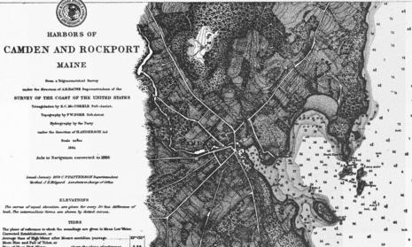
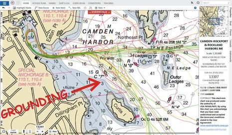 Let’s start with the fact that the big sloop grounded right on the clearly charted 3-foot area that’s also guarded by green USCG navigation buoy C “7”, seen above on the 1:20,000 scale NOAA harbor chart available for this area (though little of the Maine coast is charted in such detail). But please don’t make presumptions quite yet.
By the way, note that NOAA recently removed the partially misplaced and confusing “private aids” that Camden uses to mark the channel between the mooring fields, which I gently complained about in 2010. Note, too, how the somewhat random set of Gizmo tracks seen on my office copy of Coastal Explorer pretty well defines that channel and also indicates that I, like most local boaters, rarely mess around in that shoalish area between C7, Curtis Island, and Dillingham Point.
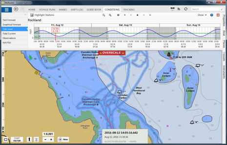 But here’s last Friday’s Gizmo track, with Coastal Explorer now displaying the NOAA ENC vector chart — C7 and the 3-foot area still quite visible — and also the state of the tide when I first saw the grounding. But at least half that track was made before the grounding. As odd as it sounds, I was already specifically trying to investigate the 3-foot area because a Camden Select Board member recently witnessed a lesser grounding there and asked the Harbor Committee to put a cautionary marker on the spot. The committee wasn’t particularly enthused — “there’s a reason for Can 7” being the general sentiment — but for me it was also a good opportunity to test several forms of sonar recording and sharing. In hindsight the sonar did reveal more of a problem than I’d realized, but frankly I didn’t really notice it until…
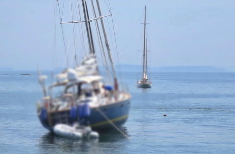
 …I was quite surprised to see the sloop hung up hard — bow thruster fully emerged, in fact — right where I’d been surveying about an hour and half earlier. Those poor sailors identified the reported trouble spot better in real time than I did with all of Gizmo’s sonar gear.
To be clear, this view is northward with Can #7 seen just right of the grounded boat’s bow (and taken just after I’d made another track through the little-used Dillingham/Curtis passage). At left is the crew kedging an anchor, which they then used in an attempt to twist the stern southward and motor in reverse off the obstruction. That did not work at all, and frankly was not a good idea given that the tide still had a few more inches to fall and there were barnacle covered rocks visible around and beneath the hull. But there’s more to that story, too.
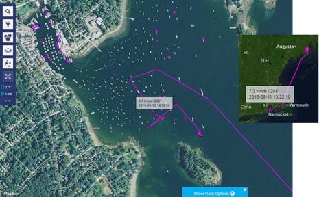 Thanks to Marine Traffic and the volunteer AIS listening stations which make it work (more needed), we can see that before the grounding these sailors had been underway for over 24 hours. They left Rhode Island just after dawn, local time, on Thursday and crossed the Gulf of Maine during the night. They may well have encountered thunder storms and/or fog, and the trip would have been tiring even if they didn’t. Using the larger image above, you can almost hear what happened next. They were likely talking by VHF or cell phone to the yacht club or marina as they entered Camden Harbor and just a little way into the channel they got assigned a mooring on the north side of Curtis Island. So, they cut through the mooring field until — bang, grind, done! — their keel found that shallow rocky patch and they eventually realized that they had to sit there for several hours before getting to rest, eat well, and enjoy this beautiful town. I did actually hear some of the cursing.
I don’t know about you, but it took me a while to realize that my nautical skills and judgment are substantially diminished after a night or more underway. And, by the way, I did motor over and try to comfort the grounded sailors about how soon the tide was going to change. The AIS history helps to better understand their mood (and I swear I was not grinning like Uncle Fester ;-).
It happens that I was also testing a Garmin Virb XE camera mounted at the masthead along with the recently discussed gWind sensor that is also wirelessly integrating with Gizmo’s just installed GPSmap 7612. The results are pretty sensational and will get detailed coverage soon, but the story told here is how innocent it looked to drive through the mooring field to that cursed spot. Note, for instance, how the bottom appears quite flat with the depth gradually increasing as I motored toward the grounded boat (though it would be nice if Garmin’s Virb Edit team turned the depth graph right side up).
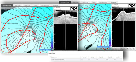 Navico GoFree Insight Genesis provides the best sonar information about the grounding spot that I’ve collected and viewed so far. Please click the collage above bigger and look for the little orange track dot on the left. At that moment I was doing a clockwise loop around the grounded sloop quite close to its port side and looking down at some scary rocks, as suggested by the DownView sonar window that goes with that track point. The righthand screen shows an even steeper and pointier situation that I’d imaged earlier in the day and higher on the tide (but didn’t notice at the time). Also, included in the collage is the tide offset information for the processed sonar map, and it looks reassuringly accurate, though I suspect that one or more of those rocks may be less than 3-feet deep at Mean Lower Low Wide (or MLLW, the chart depth datum). And remember NOAA’s recently discussed Zones of Confidence; this area was last surveyed during the period 1940 to 1969 and thus NOAA’s accuracy confidence is no doubt low.
At any rate, this sort of hard-edged irregularity is not what you see on sonar around most of this harbor and not what you might expect from that large area evenly charted at 3 feet, but it is potentially much more damaging to a boat than a soft flat bottom. Perhaps NOAA should add some “+” marks indicating submerged rocks, but would that really help? I’m not even sure that the one-foot contour lines guesstimated by Insight Genesis from my sonar log describe the bottom precisely; I suspect that it’s more like a field of bumps. But I’m certainly glad that Navico’s data collection technique includes the raw sonar data (though the large files also make it the most cumbersome system to use in my experience, and I still can’t see all the data I’m uploading, like StructureScan and ForwardScan.)
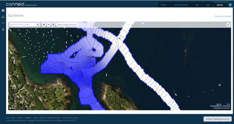 Here’s what Garmin Quickdraw Contours look like now that users can also share them online. I was disappointed that the Quickdraw specific points of interest that you can add on an MFD don’t seem to travel with the community files (yet), and I also doubt that those soundings are tide corrected, but the collect and share system is young and mostly aimed at fresh water, and it’s pretty easy to use even now.
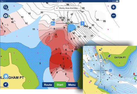 Meanwhile, the trailblazer of crowdsourced sonar data, Navionics, also has a Community Edits feature that I used to mark the trouble spot as rocky area that may be shallower than charted. That might really help as many boaters use the Navionics apps and Community Edits can also be seen on many chartplotters (compatibility guides here). But I did not use the SonarChart Live data above to locate the spot because it seems to be a little askew, and also because I came across a confidence-shaking 2-foot spot on the current processed SonarCharts for the entrance to Camden Inner Harbor. That spot would be stacked up with yachts if the SonarChart was anywhere near true, and I may have contributed to that bogus crowdsourcing. Doh! (And nonetheless I hope to try the Raymarine LightHouse 17 version of SonarCharts Live soon.)
I think that crowdsourced depth data is an interesting work in process, especially for tidal areas and especially for this sort of “watch out” detail. But it is helping me to document the issue, crowdshared points of interest like Community Edits do work to some degree, and I’ve already added an Active Captain hazzard mark which will be seen by many cruisers new to the harbor. I was a little surprised at the FaceBook effect, however. I posted that masthead video on my personal timeline yesterday and a number of local boaters have already reported bumping on that little rock patch, which now looks like it’s safely among deep-draft moored boats. Maybe the momentum builds for the town to mark it with a pole or isolated danger buoy?
 Some will say that the chart and C7 buoy mark the danger well enough, and certainly a whole lot of boats did not go aground while that nav aid has apparently been on the job since at least 1886. I wish I could find a higher resolution version of the old chart, but even the (click big) version above suggests that the cartographers charted some sort of ledge where now it just shows a 3-foot plain. And you can definitely see the incredible contour, road, building, and forest detail they were able to map without any of our technology. Are we really making progress?
While searching for high res antique charts I did come across a wonderful 1916 book called Glimpses of Camden (fully viewable, downloadable and in the public domain). Yes, there were few boats moored in the Outer Harbor then, but much of natural beauty and even the summer style of a century ago is still very much on view around here, and that’s why it’s worth even a long passage and/or an occasional boating surprise.
PS 8/27: There are many Maine mooring fields with dangerous spots — see Compass Marine’s list below — and sometimes they’re marked. For instance, the white danger buoy below has been charted as guarding “Harbor Ledge” in Bucks Harbor for many years and is even lit. Apparently, however, some visiting boaters still didn’t understand the danger so the harbormaster added the big orange inflatable as a further warning. And yet I’m told that the good folks at Buck’s Harbor Marine cringed as they watched a big sailboat going right over the ledge yesterday! Conclusion?


“How about a sign on the East end of the Cape Cod Canal that says ‘Danger! Fog and ledges ahead!’?”
That’s the latest comment from a highly experienced local on my FB page. I get it, I really get it, and the main reason I haven’t hit a Maine ledge in quite a while — knock on a teak rail — is probably not so much the great electronics but the fact that I hit so many in my earlier years.
But, jeez, don’t you often make presumptions about the safety of mooring fields (not a good idea up here)? Don’t you relax your guard at the end of voyage?
By the way, if you happen to know the boat that grounded, please keep it to yourself. I think they got the point, and shame is not the game.
Shame? no shame here. I could have been following their same path with the same result. Almost all mooring fields fall outside of the marked channel. So, in my opinion, minding C7 means nothing. Once I enter a mooring field I look to be sure I’m motoring among sailboats of the same approximate size and “assume” if they are floating I’ll be floating. With the entire Camden mooring field outside of marked navigation I would not be looking at navigation marks. In your video, the grounded boat had just passed several other sailboats of similar size with an empty mooring just to port. How can anyone fault them – it’s the perfect misperception. Why would it be such a big deal for the Harbor Committee to authorize a few private marks to show the limits of the mooring field in this area?
I agree that crowed sourced depths would be helpful, but don’t we tell mariners to get their heads out of the chartplotter and look around? I think the ideal would be to have someone in the crew watch the chartplotter depths as the helms person picks their way through the mooring field. After a long overnighter that’s a detail that can easily be forgotten and impossible for a singlehander.
In the end, what a great lesson for us all. Hope they got off undamaged.
Hello Ben,
And congratulations for yet another eye-opening article from you.
Rocks and shoals close to or even within mooring fields, are not so rare!
For example I did hit some rocks in Cutty Hunk while entering a mooring field; there are a couple of nondescript white buoys warning that there is something there, but they are on a very short leash, and at high tide they are submerged!
On another day, however, still in Cutty Hunk, I did avoid grounding on a rock that is next to the mooring field on the other side of the entrance to the marina, because at low tide the rock sticks out a good couple of feet.
By the way, you know that there are two types of boaters: the ones that say that they have grounded, and the ones who lie…
So, what to do about it.
The first thing is to realize that the electronic chart should not be a mere digital copy of a paper chart.
You cannot compare what you see on the charting table of a steady ship when you open a 3X3ft paper chart, with what you see on your MFD, or worse yet, on your phone, on a bouncing boat, with the sun and salt and spray obliterating your ability to see the chart. The paper chart was designed to be used on the charting table of a large ship, and if reproduced verbatim in your 4” smartphone, can be very deceiving and dangerous. The grounding of Vestas on a 30 mile reef in the middle of the Indian Ocean during the Volvo Ocean Race is testimony to that.
What Navionics has been doing about it, is to “exaggerate” hazards so that their existence can be noticed even when using high zoom levels (little detail). This is work in progress, so it does not yet apply to all the millions of hazards like the one you are covering, but if you look at the oceans on our app, you will see all the exaggerated shoals and reefs that would be otherwise invisible. You will also notice that instead of the standard icons for dangerous rocks we have adopted one which is far more noticeable.
The second thing, as you pointed out, is crowdsourcing: no hydrographic office can deploy millions of surveyors, but the boating community can.
As I have shown in a scary video of a Scandinavian regatta at the press conference that you attended in Miami, through our Community Edits we now report tens of thousands of rocks and hazards that are missing in the official nautical charts. With minimal personal effort, and a sense of community, every boater can report any missing hazard and the entire community have their charts automatically corrected within 5 minutes.
Last but not least, educate boaters than no chart is error-free, and good old prudence and crosschecking of multiple sources of information is always needed
Cheers
Giuseppe Carnevali
President, Navionics
Crowd sourcing is a wonderful tool, when as you note the data is accurate and not fuzzed by errors.
I’ve bounced the centerboard in Penobscot, Casco and elsewhere in part due to being tired or confused and in part because I assumed that the chart/position was accurate enough, or I had delegated steering to someone who had the chart in North up vs Course up etc.
A forward scanning sonar is a very helpful tool, IF you are going slow enough that it can warn you before you ground.
Given the steep profile of the contours, its not clear that the grounded vessel would have had time to do much even if it had a downlooking sonar set 1/3 of the LOA back from the bow and a helmsperson watching it religiously.
As you note if the hazard is rocks then looking down only shows them when you are on top.
I’ve towed a boat off in that area ca 2002, who anchored, and then swung overnight above a flat ledge, where they awoke on the ebb, at about at 15 degree increasing heel.
Fortunately we are 4′ with board up and could take a halyard far enough to heel them and slide off before the tide went out too far.
Interesting article. I thought I’d let you know about NOAA’s Historical Map and Chart collection, at https://historicalcharts.noaa.gov/ The images are high resolution and you can download or zoom in for exquisite detail.
The Harbors at Rockport and Camden chart from 1864 is at https://historicalcharts.noaa.gov/historicals/preview/image/CP1015C
Hi Ben, I had the passing thought that if there is a known and perhaps not well charted hazard that boaters have encountered before because of maybe somewhat confusing private aids the city parents could be liable for not clearly marking a navigation hazard in a busy harbor.
As to crowd sourcing the Sarasota Yacht Club (Check their website) does an excellent job of mapping and maintaining our shifty Big Pass. The have a dingy equipped with a small Garmin unit. They made an accurate homemade tide station at the club and they know the transducer offset. Volunteers take the dingy out into the pass regularly, zig and zag a zillion times through it and use the track point data to create an high rez color coded contour map of the pass.This doesn’t take very long to do.
Using sonar contour mapping tech would be even easier than dealing with the track points. Paying attention to the tides and xducer offsets will produce a more accurate chart than the NOAA product and a small dingy can go places in the harbor that larger boats can’t. You never know what you may find in the process especially if you’re recording side and down view sonar. I would think in two days or less the job could be done.
Right on Richard C!
Nice article, Ben. I’ve convinced myself, after a few memorable groundings, that I am an above average, careless navigator.
There seems to be an ‘old salt’ rule that says; if you ground, don’t tell anybody. Boat yards often put a ‘mums the word’ on groundings.
That’s just silly pride and it’s too bad: Others can learn something even if it’s not your boat. Groundings happen.
I know that spot well so I probably wouldn’t make that mistake (unless I was distracted…). But it’s easy to see others could, especially those new to the harbor.
Does the harbor committee have that ‘old salt’ attitude? Right in a busy harbor, NOT putting a white ROCKS buoy between 7 and Curtis Island, is old salt silly.
In this era of bright screens onboard that show the boats icon hitting the rocks at the exact same moment the crew feels the crunch, the answer to groundings – still – isn’t in the tools of navigation.
As an AACN (above average careless navigator), I make vivid mental notes of groundings, my own and others. They flash through my head at random and remind me to simply, navigate. It works.
We happened to be on a mooring that we had dropped to head into Camden to Wayfarer. We were about 100 yards away, farther toward the mouth of the harbor.
I saw the sloop in question and offered to help. They wisely told me they had found a very shallow place and we’re going to wait for the tide to rise. They were pretty embarrassed. I think it was the professional crew without the owner.
I then checked the chart. Lucky I didn’t approach them. ;-))). I draw a little different less than 7.5′.
It does get shallow there!
I also am a supporter of the concept of crowdsourced data, but there is no point in going thru with the exercise if the data is not accurate. When I began as a beta tester for the ARGUS project, I calibrated my two depth sounders, and accurately set the offsets using a long pole and a tape measure. ARGUS reports only data generated by cooperating vessels, and doesn’t try to guess what the bottom is like between the vessels tracks and the shore. I encourage others developing crowdsource data to do the same.
I don’t care if my depth finders are accurate in deep water. But I since I draw 4.5 ft, I surely want to know if the depth is six feet, or four feet.
I don’t think there is any shame in running aground. As Giuseppe said, “there are two kinds of boaters…..”. I once ran aground twice in one day, both at low speed in soft mud. That is why I keep my TowboatUS membership current.
Ben,
As we discussed the other morning at Frenchboro, Maine harbors are a unique lot. It is not at all uncommon in Maine to pack the harbors with boats surrounding ledges. Camden Harbor is but one of many where I’ve known of, or seen groundings in the middle of what looks like deep water. Heck on multiple occasions I have seen boats peg York ledge, clearly day marked, in Falmouth. Just yesterday a boat nearly went on the ledge at JO Brown’s…
A couple of years ago we were next to the ledge in the mooring field at Isle Au Haut when a Back Cove or Sabreline or similar, can’t remember model, destroyed his props on the ledge even as I was trying to tell him the ledge was there. I first tried to hail him on 16, no luck, I then began pointing and giving the universal STOP signal. Still he ignored the 12″ screen in front of him, ignored me, chose not to monitor VHF 16 and it cost him big.. He tucked tail and left the anchorage doing 1.5 knots with massive visible vibration.
Anchorages with moored boats often surrounding non-navigable water (off the top of my head) please add to it….
Isle Au Haut
Falmouth Foreside
Bucks Harbor
JO Browns / North Haven
Tenants Harbor
Pemaquid Harbor
Boothbay Harbor
Harraseekett River
Centerboard Yacht Club – Portland Harbor
Blue Hill Harbor
Southwest Harbor
Perry Creek
Carvers Harbor
Etc. etc.. Navigation in Maine is not complete just because you are in an anchorage or mooring field…
As it happens, Ben, we are moored less than 100 yards from C”7″ right now, just as we were a few weeks ago when we visited with you. We rowed right across that rock this morning going to visit Curtis Island – good thing the Fatty Knees only draws 6-8″ when we’re rowing.. 🙂
The Green Can does NOTHING to enhance situational awareness in this area – it is only intermittently visible amongst the moored boats, and is literally surrounded by moorings – which are highly occupied this time of year.
The 3-foot mark on the chart is certainly a good warning, but like “Fox Rock” off Cape Blanco, putting a “dangerous rock” symbol would make it a LOT more noticeable! The symbol I’m talking about is the red highlighted crosshatch that Navionics uses, though I suspect every chart maker has something similar. Because the symbol remains obvious at every zoom level, it jumps at you to tell you to zoom in and be sure.
Adding a warning buoy to the rock might help – but with all of the various mooring buoys in the surrounding water, it would have to be pretty gaudy to attract the appropriate amount of notice, IMHO. It’s almost like you would need several buoys surrounding the rock to work properly (or mebbe flashing red neon?).
You are right about the sign at the Cape Cod canal – though some would say it should be at the C & D canal. I’m pretty proud that we’ve only found one rock with our keel on our Maine adventure (so far). That was out at Damariscove, and involved pure foolishness on my part – but it was the first bottom touch since the sand bar at the Tomales Bay entrance in May of ’15, so not too bad, considering how far we’ve been in that time.
And then Lesley got back from terrorizing the shops in Camden-towne, and had an even better idea than a buoy: put a big post on the rock – like the green daymark that sits out on the “inner ledges” – unmistakable as anything but a hazard!
Thanks, Compass Marine! I think that Rockland makes the list too, both for the 3-foot lump in the small mooring area off the launching ramp toward the harbor’s south end, and the 6-footer in the mooring field off Knight’s Marine and the ferry slips.
Thanks too for the expert help tuning my Balmar 614 regulator to best charge the Firefly batteries. Your suggestions helped a lot and now I also have a better understanding of what the advanced settings do. Please do write about how it works.
Thanks Hartley. Note the PS I just added showing the double danger marks on the ledge that lays among the moorings in Bucks Harbor. And that when I called the marina there this morning to confirm that the big orange buoy went in because many boaters ignored the fairly big white one, they told me that some boats still ignore both, like yesterday after we left. A steel pole would be good, but hard to install on rocks that don’t uncover, and maybe there’s no danger mark that’s completely fool proof.
If somebody drove between those two buoys in Bucks Harbor, there may not be hope. Maybe the problem is the soft and “bumpable” nature of these buoys – how about take one of those old steel mooring balls and weld on a bunch of heavy metal rods so it looks like a WW2 mine? I know I would stay a long way away from one of those!
I’ve heard that the effort to make thing fool-proof just leads to a more advanced grade of fool.
Some captains are not ashamed to have gone aground and they blog about it. Of course, that was under ideal conditions, on the coast of Netherlands.
http://www.odaogsnuppa.com/#!Turens-f%C3%B8rste-krise/flle4/57bf2d7cf97b695dfdf3b1e8
The page is in Norwegian, so use Chrome or Google Translate to read it (not a perfect translation, but not bad either). Or just look at the photos.
I have to say I am really confused…
The shallow spot in question WAS on the chart. So what good would “crowdsourcing” have done? If Crowdsourcing means collecting sonar data from “the crowd’s” boats, you would actually get very little data from this spot, because the only people who drive over it get stuck!
I can see crowdsourcing might have the potential to identify uncharted rocks or other hazards, but in this case I don’t see what it could possibly have added to the chart that would have prevented the problem when all the data needed to avoid the grounding was already present.
On the subject of crowdsourcing in general… Maybe I am too much of a curmudgeon, but I doubt I will ever trust data that comes with no real quality assurance or provenance. Yes, I know that many charts are based on sometimes laughably out-of-date survey data, but if I look at my chart I KNOW that, and can take it into account when I make decisions.
I look at the amount of mis-information that accumulates in databases like ActiveCaptain and I can’t imagine trusting my boat to data input by random people. I don’t trust the average boat driver to have the level of competence and awareness to develop mission critical data for me.
By the way, there is already a system for “crowdsourcing” data onto nautical charts. If you find an error in a local chart, contact the LNTM. The appropriate email is listed in every issue. I personally know of at least a dozen chart corrections that were implemented because of email conversations between local mariners and the USCG.
Oh— wait a minute… do any non-professional mariners even know what the LNTM is anymore?
Thanks, Panbo–
This rock is not on the charts.
Can C7 does not mark the rock.
The mooring field envelopes this rock in a deceiving way.
Thanks to everyone who has pointed it out– in their own ways.
It’s a darn poor 4th of July for a big sailing yacht that’s keeled over on that same ledge right now, despite the fact that the Camden Harbormaster has a danger buoy on it.
Hopefully the 8:45pm high tide will float them free before the fireworks start going off on the nearby barge.
And at least one wag thinks the scene is somewhat appropriate given the yacht’s British flag.
I’m not too proud to admit that through some fault of our own, my friend and I hit this rock, or these rocks, over the past summer (2017).
We were working our way to the edge of the mooring field, saw the buoy marking the rock some distance off and stayed northeast to avoid it. But evidently we were already too close and banged up the keel. If memory serves we were just at the edge of the mooring field.
If anyone’s interested in the account or damage, or even if you just want to make fun of two green sailors:
http://www.sailingdowneast.com/maine-north-haven-to-camden
And an update from 2018 – we’re moored right by Green 7 again, and I spent a while examining the area. There are even more moorings around the rock than before – basically they’ve followed the contour around on both sides. There is no mark on the rock itself at the moment.
On the plus side – Navonics now has not one, but TWO “dangerous rock” markers in the area – this is excellent for those using these charts. The only other clue is the absence of lobster pot buoys in the area (which should make you suspicious!).
And a followup – Ben doesn’t think there are more moorings around it, and he may be right – but it’s surrounded on three sides with moorings, so it’s well camouflaged!
I took my kayak over there at low tide – it’s easy to spot ‘cuz there’s a nice long gouge in the marine life stuck on top of it – shows up nicely in that clear water. The local launch driver didn’t think anyone had hit it this year (yet), so it might be a year or two old.