
Vexilar T-Box WiFi fishfinder & Navionics SonarChart Live wow
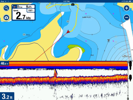 This mid-January screenshot represents a very pleasing experience in marine electronics testing. Thanks to a Vexilar SonarPhone T-Box SP200 and the Navionics Boating app I’m cruising around in my 9-foot dinghy with more than just charting and a fishfinder. I have access to three different chart formats plus a live SonarChart being created as I move along, and the data I’m collecting will be available to my fellow cruisers a week or two later. It sounds exotic, but the total cost was about $250 (iPad mini excepted), installation was fairly trivial, and it all worked quite well right out of the box.
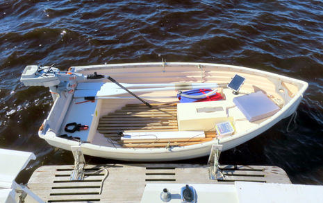
Here’s the tentative Vexilar test setup on Gizmo’s tender, which had just been dubbed Gadget when the iPad got TorqTrac monitoring for the Torqueedo electric outboard. I just mounted the little dual frequency T-Box transducer on an Azek board that I could clamp to the transom and went “belt and suspenders” with the waterproof wifi box itself by putting it in a tight plastic food box with a 4 amp hour rechargeable AGM battery from Walmart. (Dinghy afficionados may appreciate the custom fender/cleat hardware I had made last summer so I can use the swim platform like a dock without adding cumbersome Weaver clips to the fine Fatty Knees 9. The clips would be more secure, especially with Gadget “folded up” and Gizmo underway, but I like how I can easily haul the light FK9 into the cockpit, right side up and heading in the proper direction.)
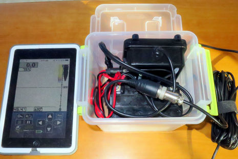
Here’s the $150 T-Box SP200 being tested in Gizmo‘s salon with the included SonarPhone app running on the mini. I also tried the Android version when I tested the Vexilar T-Pod model meant for shore fishermen, and saw that app made even that “bobber” style transducer act like a pretty full-fledged fishfinder. Incidentally, I was pleased to meet “Mr. Vexilar” Tom Zenanko and learn more about Vexilar’s long and distinguished sonar history. They are not a small company, apparently dominating ice fishing in the icy midwest, and they’re darn excited about the global opportunity they’re finding with the SonarPhone line.
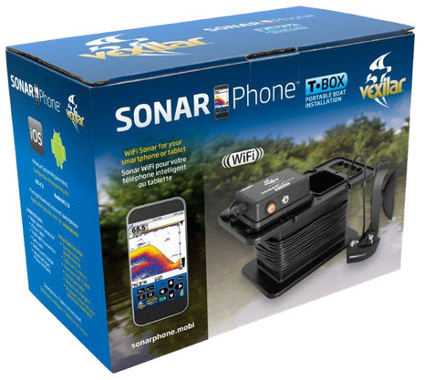
In fact, Vexilar is already out with the SP300 T-Box portable boat install kit that seems to do what I did better and cheaper. For $200 you get the SP200 with transducer suction mount, a 4.5 amp hour battery, a case that organizes all of the above, and a 1a charger. Obviously, this makes trying T-Box WiFi sonar on a small boat much easier, but I’m probably going to install it semi-permanently in Gadget — think solar-powered battery for sonar, bilge pump, and whatnot hidden under new seat hatch — mainly because the SonarChart integration is such a blast.
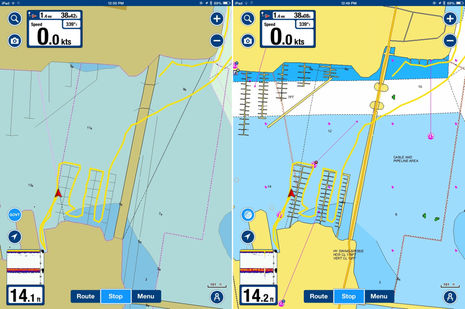
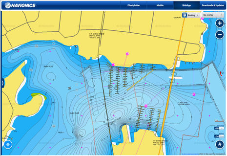
The first you’ll notice about the integration between the Vexilar sonar and the Navionics Boating App is that it just works. As long as the iPad (or Android device) is pointed at the T-Box WiFi, that little fishfinder box will pop up on the screen and can be made split window with a tap. Before moving on to the Live SonarChart feature, note the depths around New Bern harbor as presented on the “Govt” chart — the Navionics version of NOAA vector charts that comes with the free version of Boating — and on a regular Navionics+ chart. I point this out because the SonarChart I downloaded before this testing was terrible!
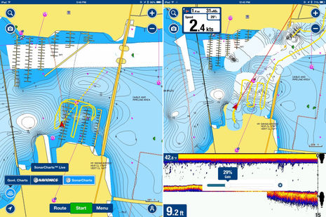
If the actual depths were remotely like what was shown on the existing SonarChart, Gizmo and a whole lot of other boats currently tied up in those two marinas would be hard aground. Fortunately, this is about the worst SonarChart example I’ve ever seen, and Navionics subsequently told me that marinas can be a particularly difficult issue. But be careful, boaters, a whole lot of bathy lines do not necessarily connote accuracy. These screens also show what the chart selection and SonarChart Live overlay buttons look like when you tap the Chart Type button, plus the sonar Gain control you can tap into on the full Vexilar window. And if you click the screen above bigger , you may notice the funky spot soundings in the Live sonar swaths that had me confused for a while.
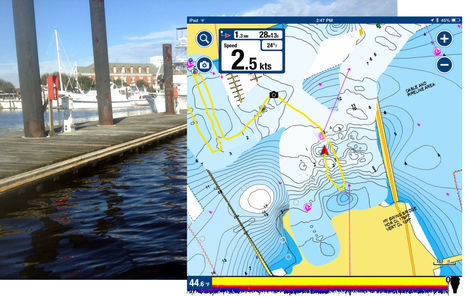
I guess it makes sense in retrospect, but the depth numbers shown in SonarChart Live are not related to the live data being collected; they come instead from the underlying chart. So, given the bad original data in New Bern, I was seeing sensible bathy lines and shading with weirdly shallow spot soundings. Also, somewhat disconcerting is the aggressive way SonarChart Live guesstimates bathy lines about 80 feet to either side of your track, regardless of depth, and also wipes out bridges, shorelines and docks along the way. If what I mean isn’t obvious from the screens above, the dock photo was taken right where the Camera icon is (a nice Navionics feature).
But my North Carolina test site probably highlights this aspect of SonarCharts Live a lot more than other uses like, say, mapping a lake or pond with little or no existing bottom info (which still exist all over this country and the world). And because Navionics has just gotten started with this Live presentation, it will probably improve over time. For instance, I’d like to see all the yellow tracks (or a light dotted representation) shown for all Live SonarChart data. (Tracks are displayed independently now and only one at a time while the SonarChart Live data seems to accumulate as a single overlay). Overall, though, SonarChart Live should always be thought of as raw data, and you may be as pleased as I was with what it looks like after processing back at the cartographic mothership.
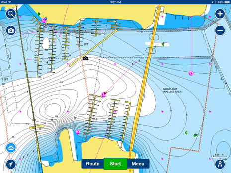
Here’s the SonarChart I downloaded from Navionics to my iPad a few weeks after my SonarChart Live data was automatically uploaded, and it may well be the best bottom detail of New Bern available, if I do say so myself. Actually, it would be even better if Navionics hadn’t ignored some of the data I collected along the shorelines. For instance, I surveyed that deep water slip (just above the “Route” button) where BridgePointe Marina has its pump out station and boat project area (pictures here).
But I quibble. Navionics SonarChart Live is a big deal, I think, and definitely worthy of the MIBS Innovation Award it received in Miami. I can picture all sorts of fishing and cruising uses, and it’s great how many other ways there are now to access (and contribute) SonarChart data. You can, for instance, easily check out my New Bern work via the fast Navionics WebApp chart viewer. And anyone with a current Raymarine MFD can get fresh SonarCharts either via a Navionics card update or wirelessly via from the Boating app (as I first experienced last summer). However, crowdsourced chart data is becoming such a hot and potentially lucrative area that there may be some trouble brewing, and that will be the subject of the next entry.


You can now use the LIVE-feature with Lowrance/ Simrad WIFI as as a source as well. So no need to go with the rather simple sonar of Vexilar. 😉
Righto! I just downloaded the 7.4.1 update for iOS and see that there’s now also numerous controls for the display of raw Live SonarCharts, like color and transparency.
I can’t figure out how the app connects to NMEA 0183/2000 WiFi depth data feeds, though, unless it’s totally automated somehow. And note that such feeds from Navico GoFree, Vesper AIS, Digital Yacht WiFi appliance or wherever can NOT enable the Navionics app to show a fishfinder screen like the Vexilar connection can. The Vexilar T-Box is also well suited to a tender, which is also a good platform for collecting sonar logs in shallow or unknown places.
Totally automatic. I tried it out yesterday: http://teamcolibri.blogspot.no/2015/03/navionics-sonarcharts-live-na-via.html The text is in Norwegian (sorry) but I guess the screenshots tell the story.
For me, fishing is why I boat. And while I have a Vexilar SP200, the sonar on it is not even close to the stuff I’m used to. So missing out on that is no big loss for me. I had three HDS 5 on my former 13′ boat, so the “well suited” part is up for discussion, as long as you use it for fishing. 😉
Thanks, Erik, great screen shots and Google does a half decent translation. Did you get confused like I did by the fact that the spot soundings in the SonarChart Live swaths are from the underlying chart, not your soundings? A friend in Florida just had that experience and, like me, surveyed the same area over and over hoping the spot soundings would get right.
I hope Navionics reconsiders that SC Live detail, and meanwhile they’ve posted good directions on how to make it work with a Digital Yacht WLN10 Wireless NMEA Server: http://goo.gl/TgWl09
Yes, thanks for that blogspot link. I have a few comments. First you say the echo sounder in the SP200 is so bad. It’s just a depth sounder, not a fishfinder, not a CHIRP fishfinder. Is it really fair to say it’s bad because it’s not a fishfinder, or is it really bad, for a depth sounder? I haven’t used one, so I have no opinion in this, other than to say that for charting the waters where grounding is a problem, how could it not work?
The final paragraph says that it is not legal to log depth data in Norway and Sweden and especially not in Finland. Between not helping Russian subs and not going aground yourself, I don’t think that choice is too hard. Giuseppe Carnevali of Navionics reportedly said at the Miami International Boat show that there are an estimated 35,000 rocks in Norway that are not charted at the present time.
Finally, the nice screenshots point out what I think is a flaw in the Live charts. Each traverse is a record of a depth sounder without side scan, so it should show up as a narrow path with no transverse information. Yet, each path leaves a trail of hills or contour line bubbles behind the boat. That is just strange. There is no attempt to merge with older data that I see, although maybe Navionics processes the data with better algorithms when they receive it. The best results would be from combining all inputs, not just taking the most recent as the best. I’d like to know more about how this works.
Norse, the Vexilar SP200 is a fishfinder — see screenshot at the top of this entry — but it’s a very small, inexpensive fishfinder.
Navionics SonarChart Live does make big assumptions about depths left and right as you cruise along, but it should only be looked at as raw data anyway. The Live imagery is not corrected for tide levels and not at all integrated with existing data. That happens a couple of weeks later when the updated SonarCharts are available.
All that said, I’d like it if the SonarChart Live “swaths” included track dots with depth readings, at least optionally or at a close zoom.
Ben, thanks for correcting my mistake. In fact Vexilar claims the SP-200 “will rival any high end sonar on the market today”. So any comparisons are fair. Why does Erik (and others) say it is not good?
BTW, the 35,000 rocks quote I credited to Navionics. A Navionics YouTube credits it to the Norwegian Coastal Administration.
Comparing the Live version above of the N.C. test and the version after “processing back at the cartographic mothership”, the Live version goes overboard and the final version dials it back. I think Navionics should make the Live version more conservative to start with. Just my two bits based on limited knowledge so far. User reviews are still scarce at this point. It looks useful for tenders and kayaks which can explore and map the shallows without risk.
Thanks, Norse. I think SonarCharts Live is very much a work in progress and I gather that there will be lots of changes in its presentation and abilities in future Navionics Boating app updates.
Yes Ben, the spotsoundings vs live can be a bit confusing. But even more confusing is the fact that you “overwrite” contours of land and islands along the way. That rock in my screenshots almost disapears as I logg data around it.
Norse, I do not see Live as an alternative to “real” mapping. So the rather blunt function of it does not bother me. I use Reefmaster to make my own charts, as well as Insight Genesis. Both outperform Navionics Live by a mile, with Reefmaster beeing the most complex but also the best of them. But with the collected data beeing crunched through Navionics own programming, the finished update on a Navionics map will probably look quite different from the live-version. (I can’t compare this, since Navionics by Norwegian law is unable to use the data to correct their maps.)
The marketing for Sonarphone (as well as it’s competitor Deeper) is quite aggressive and does claim that their sonar is a great fishfinder. This is essentially BS when compared to high-end sonar. Sonarphone is better then Deeper, but it is not even close to a high-end CHIRP-system and Airmar ducer like I normally use. But I don’t expect it to either, given the difference in price. (You can buy several SP200 for the price of even the cheapest of Airmars CHIRP-ducers.) My point is not that SP200 is bad, it’s just that there are ways to have both great sonar and Navionics Live at the same time. Cheap sonar is a lot better then it used to be, but expensive sonar has gotten better as well, so there is still a significant gap.
hello, i use vexilar t-pod and really want to be able to build their depth maps. but where I fish there is no coverage from Navionics. Perhaps there is a solution as to record the logs? I think it is not difficult and if Navionics made to write the log to the internal memory of the device would be very nice!
Pav, I think the SonarCharts Live will work anywhere, regardless of underlying charts. It would be interesting to see what they look like after processing into regular SonarCharts.
Cool: Digital Yacht just introduced Sonar Server, a WiFi box with NMEA 0183 input especially designed to make SonarChart Live work on an Apple or Android mobile. Perhaps most impressive is all the specific instructions and diagrams about how to install it with even aging electronics:
http://sonarserver.com/
The Sonar Server sends GPS and depth to WiFi. What else does it send from the NMEA 0183 stream to WiFi? I wonder if it and the Navionics app could possibly use Signal K …
dos it work with the vexilar sonarphone t-pod to? i dont mean the sonarphone sp200 model. any answer i am greatfull for. thank you
Hey guys, I just got a Vexilar T-box and used it on a fishing trip about 20 kms offshore Arabian Sea. On my mobile screen, few big fish were shown at the bottom. What could be a way to know the exact spot where the fish are at the bottom. The water depth was 70′. Thanks guys…..