
The Navionics SonarCharts for Garmin conflict, messy business!
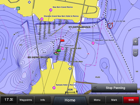 This screenshot shows the Garmin GPSMap 8212 installed on Gizmo displaying the same crowdsourced Navionics SonarChart bathymetric data that I recently enjoyed improving via the Navionics Boating app and Vexilar dinghy sonar. In fact, all the chart data seen above came from Navionics, even the beta version was fairly usable for navigation (I thought), and the finished chart cards are now for sale. But I doubt that many will be purchased once potential users realize how Garmin is reacting to this development! Navionics and Garmin seem nearly at war, and this entry will attempt to untangle what’s happening. I fear there are no heroes in this battle, and it may even foreshadow further tensions in the critical world of chart and plotter manufacturers…
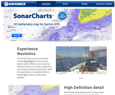
Navionics announced SonarCharts for Garmin during the Miami show, and the enticing HD bathymetry map for Garmin GPS page above went live shortly thereafter. The concept is attractive as the first real alternative to Garmin’s own charts and one with nearly worldwide coverage and support for crowdsourced depth data that you can easily improve yourself. But a prospective buyer who clicks on the little, “Verify that your plotter is compatible with this product here…” link will discover a very disturbing caveat:
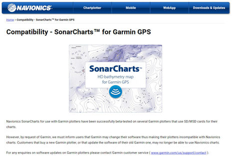
Indeed, Garmin has stated that they will change their plotter software to make these Navionics chart cards incompatible, no may about it. In fact, Garmin sent out a dealer notice making the same threat in early December when the somewhat public Navionics for Garmin beta program was getting started. So Navionics doesn’t have grounds to act surprised about what is happening and the implication that Garmin made them put up the notice above also seems calculated. What happens when someone buys a Navionics chart card for Garmin and it suddenly won’t work? Will Navionics blame Garmin or apologize and refund the sale? I’d think it would be a hassle either way, and that Navionics has an obligation to make this caveat crystal clear to all prospective Garmin card customers.
The apparent Navionics strategy is to get the product out there and hope that Garmin users will want it so much that they will shame Garmin into supporting it. And you can see the strategy bearing some fruit in this Hull Truth forum discussion like, “Well if Garmin does indeed break the Navionics chip from working with their equipment that does it for me ever buying another Garmin product.” Yike!
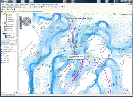
But Garmin is playing hardball, too. I liked using the Navionics SonarCharts with Garmin HomePort Win/Mac software. Just combining track histories (which can go to Navionics as sonar logs), ActiveCaptain info, and the SonarCharts I helped make for the Barred Island anchorage above was interesting, and this free program can now play back SideVu, DownVu, and sonar recordings with synchronized track animation. So, it could be a great tool for someone surveying a pond or a wreck (as well as the fine planning and logging tool it’s long been). But early this week I updated to HomePort 2.2.9 — which adds more sonar viewing features — and the Navionics SonarChart cards no longer work. Hardball!
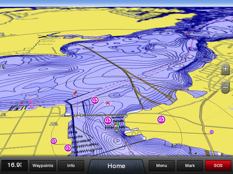
I also checked with Garmin this week and their position has not budged: “We acknowledge and regret that Garmin’s response to the distribution of ‘SonarCharts’ for Garmin chartplotters by Navionics has led to frustration for many boaters. However, the basis for our decision has not changed… Garmin will continue to make the necessary changes to our marine products to ensure only content that is authorized to work on Garmin systems will do so.” So, unless I never update the 8212 and 741xs again, the screens I’m illustrating this entry with will soon become history on Gizmo. As shown above, the SonarCharts can compare well with the BlueChart g2 charts built into most Garmin MFD’s (I don’t have a BlueChart g2 Vision card for this region, which would show more detail). Personally, I can’t imagine not taking advantage of Garmin’s generally terrific update policy. The big one in January, for instance, was full of valuable improvements like Race Start Guidance and neat DSC distress assistance.
So, how did Garmin and Navionics get into this messy situation, and what are Garmin users to do? Before getting into the business intrigue, let’s look closer at the Garmin SonarCharts, which seem more radical than many have noticed.
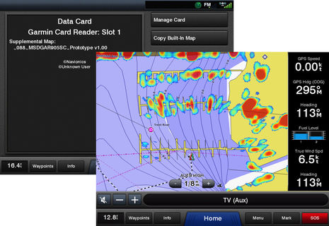
When they work, Navionics SonarCharts for Garmin are treated as a “Supplemental Map” and are only recognized if you insert the card after the MFD is powered up. They do work with radar overlay (above) and even in 3D mode (below), but they are not treated like regular charts. Specifically, you cannot create a split window display with BlueChart on one side and SonarChart on the other. This is important because the Navionics charts for Garmin do not include official depth soundings, just SonarCharts. In fact, I can’t think of another Navionics chart product, apps included, that can’t also display regular Navionics charts (based on official data) along with SonarCharts.
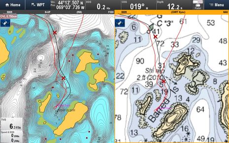
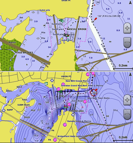
Consider this Raymarine gS12 screen showing that same Barred Island anchorage and also the moment I fully experienced the great collaboration between Ray and Navionics. Sonar logs had easily gotten to Navionics via their app’s Plotter Sync feature and then the processed SonarCharts came back to a Navionics+ card so I could use them on a real MFD. Any cruiser using SonarCharts has better info on the anchorage now, myself included, but I don’t use SonarCharts exclusively. Remember the New Bern, NC, SonarChart showing very shallow waters in two marinas where big boats have been berthed for decades? SonarCharts are almost the opposite of official hydrographic office data – nimble but possibly flaky, versus highly validated but slow to change.
That’s why I’m using a Lighthouse NOAA raster chart alongside the SonarChart above — old school, new school style — and a regular Navionics chart off that same + card would have served as well. And note that Raymarine does not overlay navigation aids on SonarCharts, which I take as a statement that they should not be used for primary navigation. Actually, I wish Ray would relent on that point, as the aids help with situational awareness, but the bigger point is that perhaps Navionics’s closest partner won’t support charting concepts that Navionics is trying to bring to Garmin without any partnership at all. Or so they say…
Here’s more of Garmin’s recent statement:
This beta Navionics product, and the tools used to create it, were developed without Garmin’s participation, and without any access to our map design specifications. It may be difficult to understand our concerns about this content when a beta experience appears to “just work”‘ but marine navigation systems are complex and constantly evolving. Garmin’s quality depends on our systems functioning to our specifications which cannot be assured unless we have the opportunity to work with a partner. There are numerous examples of Garmin’s willingness to do this in all of the markets we serve. However, business relationships require agreements for requirements, responsibilities, and perhaps most importantly, the communication and coordination of changes that may have negative consequences for the customer if not handled properly.
Meanwhile, Navionics claims that it’s Garmin who won’t work with them, denying their application for a Map Product Creator (MPC) license. Navionics just “wants fair and equal treatment under the MPC, as they do with others like Fiskekort and TrakMaps.”
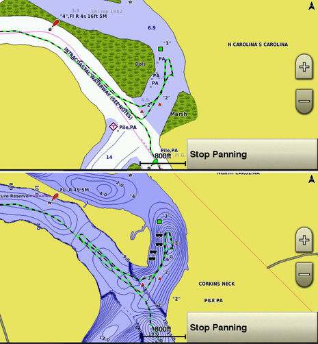
 Navionics SonarChart for Garmin detail of an anchorage I hope to visit some day
Well, I think there’s a big slobbering elephant in the room that neither company is acknowledging. Navionics is nothing like the other MPC license holders (and the license isn’t necessarily open to anyone, anyway). And I believe that Garmin could let Navionics SonarCharts work safely with their MFDs if they wanted to. Raymarine, Navico, Humminbird and others have all shown that it’s possible to support multiple chart formats, and the Navionics beta worked pretty well without any Garmin support at all. Imagine if they were actually working together.
It seems plain as day that approved Navionics SonarCharts for Garmin could put a significant dent in Garmin’s own g2 Vision card sales and thwart any plans they may have for creating their own crowdsourced data system. Which is why some Garmin customers feel hostage to the company’s business interests (apparently www.garmin.com/ideas is the best place to express SonarChart desires). But wait… there’s more. Navionics acknowledges that Garmin has wanted to license its data for some time, though that’s “an agreement architecture we have little interest in pursuing.” In other words, it may not just be Garmin stubbornness that’s keeping SonarCharts off their displays.
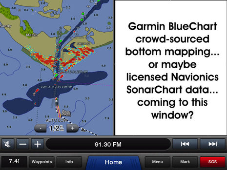
 Garmin BlueChart g2 versus Navionics Sonarchart for ICW Callabash River anchorage, NOAA version here.
What I think we’re seeing here is primarily a business conflict, perhaps even a Mexican standoff. No heroes. I certainly sympathize with Garmin customers who want more chart choices — at this point, for instance, Garmin is the only major plotter manufacturer without raster chart display. I’d also like to see crowdsourced depth data collection and display proliferate. (Wouldn’t it be great if we could upload our data to some service that would make it available to any chart developer?) But Garmin’s make-everything-themselves model has served many boaters well, and if they can integrate new chart formats into BlueChart, it might be great. Partnering with Navionics could also be great. Overall, chart sourcing and crowdsourced data are a big deal to all the navigation system developers, and we may see more public messes like this one.
Disclaimer: While I think I covered the facts of this complicated story pretty well — corrections welcome of course — my impressions are uncertain and evolving. What do you make of this standoff, and if you are a Garmin customer, what do you want them to do?


This is one more reason Garmin will NOT be considered for my next chart plotter. I am still unhappy that they discontinued and made obsolete their proprietary data cards which means my 3206 can no longer get any chart updates. Garmin made the decision to use the proprietary cards and now have made the devices that use them obsolete.
Garmin seems to have lost the focus on the customer.
Since the emergence of Personal Bathymetric Generating type systems for computers (such as Maxsea or Piscatus), it has been painfully obvious that the next big thing would be PBG on MFDs. It’s frustrating to note how long these systems are making the step. Furuno, for instance is running a version of Maxsea on the TZ touch system, surely the PBG module shouldn’t have been far behind? Insight genesis made a big step forward, but every single customer has the same blank look on their face as soon as I mention copying the data to a card and uploading the information to the internet. I’m looking forward to seeing how easy it will be on the Gen3. Humminbird have something recently but unfortunately the local agents couldn’t help when I called to enquire about it. It would seem that Garmin has fallen behind in the area – which is a pity, especially when they are pioneering recreational multibeam sonar. How is it not the next logical step to tie this to the chart?????
This basicly means that Garmin will not sell another MFD to (awake) European freshwater-users. They have not only shut the door on Navionics, but on all the users that have been making their own charts for Garmins MFDs and hand held GPS-units for years. Garmin has always had a strong following with this crowd due to their excellent GPS-accuracy, and cheap 3. party software ro make the maps with, but there is no need for a great GPS that you can’t have/ make/ buy a map for… The world is simply to big for Garmin to survey on their own.
I can only see one logical reason for Garmin to shut all these users out, and that is that they are planning to launch their own version of Insight Genesis or a similar service. Ie they are doing the same thing as Navico did when they refused Navionics to use their slg/sl2 formats.
Why wouldn’t Garmin sell more chart plotters if they offered a choice in several chart formats. Some boaters might stick with the free g2 charts, some would jump for the g2 Vision and others might buy Navionics. In the end, Garmin would have covered everyones chart preference. Instead they have annoyed many loyal customers who are now thinking about jumping ship. “Garmin, your cartography isn’t all that great! I would pick up the phone and give Navionics a call”.
I own a Garmin 740S. Unless Garmin has a change of heart on this matter my 740S will be replaced with a brand other than Garmin. Garmin’s conduct has been shameful.
Hi Erik, how are boaters making their own Garmin charts over there? Are they using some sort of Garmin software or is it third party?
We are planning to add all Garmin electronics (8212, autopilot, AIS, VHF, radar etc) to our new boat in June due to the ease of use of Garmin products and to facilitate sharing data from multiple units with the MFD chartplotter. We also understand and have heard that Explorer charts are preferred in the Bahamas (which is where much of our cruising will be) are used by Garmin. Active Captain data is also displayed on the Garmin chartplotter (same for other mfg’s).
I like the crowd sourced idea for collecting data, but I also like the user friendly approach Garmin has incorporated in their products. Uploading a route from an iPad app to the chartplotter (currently have a Garmin 741) is easy and for me very useful. I am not saying Garmin makes the best equipment – but good enough for our intended use. (For example, I would prefer a Furuno radar but I was told that radar data from the Furuno cannot be overlaid on the Garmin chartplotter).
However, it would be nice if Garmin ICW charts had the same level of detail as the Navionics chart did in your article.
Hi Bruce, Your plan sounds good to me but I would like to correct some possible misimpressions:
* Garmin BlueCharts for Bahamas definitely include Explorer data, but so do the C-Maps which are now available for Furuno, Simrad, and Raymarine MFDs. (Also I think that the poor reputation of Navionics Bahamas coverage is overdone.)
* All the major MFD systems network radar, sonar, charts, and more between displays. Actually, Garmin is the one to be a bit careful about as the 8xxx, 74xx, 76xx, and 7×1 are all running a new software base that may network more optimally. None of the MFD networks, by the way, can work with another brand’s radar or sonar.
* No MFD can display ActiveCaptain data yet. The new Furuno TZT2 MFDs will eventually and it seems like Garmin could add that feature easily given the integration they’ve already developed between BlueChart Mobile and MFDs. Meanwhile, that route uploading you and I both like is unique — the Navionics Boating app and Raymarine used to have the feature, but it was removed as unreliable and not yet replaced — and BCM 2.0 will stream lots of weather data to Garmin MFDs (which looks like a terrific feature).
* Finally, but perhaps most important, just because SonarCharts show HD bathymetry lines does not mean they are more accurate. I’ve shown in previous SonarChart entries that Navionics makes lots of assumptions based on narrow samplings of depth soundings and I’ve seen SonarCharts that were really off though they looked highly detailed, example here: http://goo.gl/nugqtC
* In retrospect I wish I’d also obtained some screenshots of Garmin fishing charts covering the areas where I compared BlueChart g2 and Navionics SonarCharts. Almost all the chart providers have fishing charts that are apparently based on various detailed surveys that are fairly easily available but not officially validated for navigation, and may be pretty old at this point. Navionics “seeded” SonarCharts with such data and I think that’s what we’re often seeing until actual user-collected data fills in.
Could this possibly be a liability issue? As Ben said, “just because SonarCharts show HD bathymetry lines does not mean they are more accurate”. Using data obtained from unknown sources without a quality check could be the reason. I’m not sure how maritime law addresses incidents where the defense is “Well somebody I don’t know said it was OK”.
PS That said, the ICW is an ideal area for SonarCharts and similar sonar-log-to-MFD systems to flourish. It shouldn’t be too long before multiple data sets confirm the main channels and keep the details fresh, or maybe that’s already true. And good data should start filling in all the interesting but vaguely surveyed side creeks and anchorages.
I’ve already submitted lots of data to Navionics and plan to also try Simrad GoFree’s new easy sonar file uploading on the way home from North Carolina this spring. Maybe I should also set up my Garmin track files, which include depth, for the optimal 1 second logging interval?
Have you guys seen this: http://depth.openseamap.org/
Kind of what ben asked for…place to upload track data and its open source charting.
This is Giuseppe Carnevali, founder of Navionics.
I can confirm that we continue to seek and wish that Garmin would agree to a business relationship to ensure “Garmin’s participation, and […] access to our map design specifications”.
It would be in the best interest of the boaters.
We are very open and flexible to consider any business model.
We would not be amenable to supplying raw charts to be re-processed by others because we have done it before, with multiple companies, and it has never worked, because it means degrading or outright cutting off some of the most valuable components of our services, like the distribution channels and daily freshest data. Invariably these arrangements resulted in sub-standard products and services, and unhappy customers blaming Navionics for things we had no control of.
I think the customers should have the freedom to choose and judge the real thing, not a degraded version. And if they do not like it, they can always return it and tell their friends not to buy it.
Boaters do not need a big brother to decide for them what charts they should use.
In your final question: what do you want them to do?
Garmin BlueChart crow-sourced […] or maybe licensed Navionics SonarChart data coming to this window?
I think there is one simple answer: whatever each boater freely wants, out of as many choices as possible
Not going to go off on another rant here, but Garmin has always been very adamant at shows and in the press about giving the people what they want. They were the first company to issue software updates on a regular basis not just for bug fixes but to improve the quality of the experience and UI. However, Garmin has gotten away from their roots, and this issue, among others that I will not mention, will cost them the coveted market share they have tried to hard to nail down. Thank you, Signore Carnivali for contributing here, as well as all the work you and the rest of Navionics sPA to make it such a ubiquitous product. It’s a shame not everyone can benefit from the technology, but such is life. Your final answer is 100% correct. Variety is the spice of life, and the more choices the end users have is directly correlated to which system they choose; be it for now or for years down the road with that same machine. Good luck to all the Garmin owners on here, I truly hope something gets worked out and the support for SonarCharts returns.
Thanks for posting here, Giuseppe!
But, sorry, I am going to point out what seems like a big discrepancy between your two comments 😉
Personally I really would like to see what Garmin could do with licensed raw Navionics SonarChart data. Just because it hasn’t worked out before doesn’t mean it can’t be done right. For instance, if Garmin wants to process your Freshest data nearly as fast as you put it out, I bet they can do it. Plus they already have server-to-app-to-MFD integration in place.
Also, isn’t your desire to have as much control as possible over the user experience also a big reason why Garmin wants to maintain control over what happens on their MFDs?
PS Thanks to Adam, I spent part of the afternoon checking out the work OpenSeaMap is doing with crowdsourced sonar data and I’m excited.
I didn’t get into it in the entry, but I suspect that Garmin and other players may be reluctant to support SonarCharts because they fear that Navionics will get so far ahead collecting data that they’ll never catch up. That’s why I think the collection side should be as open source as possible, and OpenSeaMap seems like a great possibility.
I’d like to upload all my survey work to them with the understanding that while it can used in their maps it will also be available to any commercial chart developer. Then the competition is all about producing the most value with the data. Would that work for you, Giuseppe?
Garmin should take this in stride and chart a path to the future with high quality cartography or user based programs, not unto the rocks sticking to their mediocre mapping.
Ben,
Garmin charts were the main reason I elected to install Simrad’s NSO evo2 with two touch screens. Garmin has an easier to use interface but they do not seem to play well with others as much as the other three vendors.
I wanted to be able to use raster, vector and C-Map charts and Garmin said that it would be a problem.
I sure hope Garmin does not apply the same decision making to future changes with Fusion.
Henry
This is all about vendor lock. And its time the user base start pushing back.
As an end user, I want the ability to use MY preferred cartography, ability to take MY waypoints/routes/tracks between whatever gear/app I want, etc.
Some vendors are starting to “get it”, IMO Garmin is not one of them. I can move waypoints/routes/tracks between BCM and Garmin products only. I’m prevented from using best of breed innovation in cartograhy. Partly for these reasons, I am no longer a Garmin customer.
The marine slice is well less than 10% of Garmin biz. I will not trust Garmin to pursue innovations in cartography with the same passion as a Navionics (its their entire business).
There are a few distinct issues that need to be kept separate to avoid confusion.
1) Sharing crowd-sourced data vs sharing SonarChart data:
I think that sharing sonarlogs for the common good is a very good idea, and there are several international and European Community initiatives going in that direction; the only issue is to make sure that it is a veritable “share and share alike”, and none has gotten there yet.
At the very least I do agree with Ben that boaters should be allowed to share their own sonarlogs with whomever they please, one or many. Preventing boaters from sharing their own sonarlogs because they are made accessible by some manufacturers exclusively in a proprietary format, is as if Microsoft did not allow you to share your XL spreadsheets with anybody other than Microsoft.
However, one thing is sharing sonarlogs, one very different thing would be sharing or licensing the content of the SonarCharts, particularly if orphaned of their distribution system.
The SonarCharts are not merely done from sonarlogs, but from a large variety of data coming from all sorts of sources. In many countries, including U.S. and Europe, Hydrographic Offices by law must make available their raw survey data; compliance to the law is less than perfect, but a lot of data are available. There are also scores of other organizations, ranging from oceanographic and biological institutes, to research an natural resource management institutes, that have hydrographic data that are more accurate, more detailed and more up to date than those available from Hydrographic Offices. Then there are our own surveys: every year we cover millions of acres with our own professional surveys, done with all sorts of technologies, ranging from simple sonar all the way up to airborne laser scanners.
Whereas the hydrography portion of our Gold charts is generally very similar if not identical to the Hydrographic Office charts, the SonarCharts are an aggregation of the best available sources, made through a very advanced technology that has required many years of brilliant mathematicians to develop, and a most rigorous quality assurance process.
However, the world is very large and we are just at the beginning of the new age of nautical charts.
Do not forget that according to the International Council For Science, as reported by the International Hydrographic Organization, only 10% of the seafloor has been mapped to the same resolution as the Moon and Mars, and even that 10% has lots of imperfections. As an example, Norway estimates that 35,000 rocks are uncharted in their waters.
Therefore, SonarCharts are still in a pioneering stage, and while they are better than conventional charts in many places, this does not yet apply everywhere.
By consequence, with tens of thousands of changes made every day, the content of the SonarCharts is very dynamic and only as good as its freshness: with our unique Freshest Data system, all our charts are re-published and distributed every day. I am not aware of any other organization, private or public, capable of that.
So the bottom line, no pun intended, is that while we support the sharing of sonarlogs, like we support the use of open source Linux, sharing our SonarCharts would be like Google or Apple or Amazon sharing the content of their data centers only because they run on Linux.
2) Safety
All charts have errors, but different charts do not necessarily have the same errors.
It is a fact that the grounding of USS Guardian https://panbo.com/archives/2013/01/uss_guardian_aground_dnc_chart_error.html and of Vestas Wind https://panbo.com/archives/2014/12/lessons_of_vestas_volvo_wreck_but_what_about_the_c-map_grounding_alarm_similar.html to name only a couple out of many recent such accidents, would not have happened if they had used and compared multiple charts.
All navigation manuals and many plotters tell you that “the prudent mariner should never rely on a single source of information”
It is not by chance that to fly instrumental you must have triple redundancy, and the Shuttle had quintuple redundancy.
Consistent with this, and putting safety first, plotter manufacturers should make the use of multiple charts mandatory instead of forbidden. Garmin customers are the only ones that are forbidden from using multiple charts.
Sparky, if you transfer your Garmin tracks and routes to their free HomePort Win/Mac software you can export them to GPX, KML, and several other formats. Works well. The same formats and more can also be imported.
I definitely like having access to multiple chart types on a plotter, and have advocated for the feature. I also mentioned in the entry that Garmin has become the only major MFD that doesn’t support raster charts.
But as several commenters on the Hull Truth noted, no one has ever purchased a Garmin plotter with the expectation that it would run anything but Garmin charts. It’s their model.
Also, 10% of a company with some 3,000 engineers is still a heck of lot of engineers 😉
Thanks, Giuseppe. Glad to hear you support the idea of sharing raw sonar logs. I plan to write more about that idea soon.
As for sharing or licensing processed SonarCharts, of course that’s completely a Navionics business decision.
Well I am glad I am not alone in my displeasure with Garmin’s recent business decisions that leave many of us out in the cold. And I think it’s great Giuseppe posts here and seems welcome to some feedback. Good on you for at least seeming interested in what customers are really doing, unlike Garmin, who in my last correspondence with them gave me the distinct impression they could not have cared less that they are losing a really long time customer (48, 12, 12XL, numerous Nuvi’s for the car, 215, 276C, and the 3206 not to mention THOUSANDS spent on chart and map updates, I like to keep them all current) all because I have a perfectly functioning unit that I can no longer get the chart updates for.
Long gone are the days when I bought the 12 and the 12XL was introduced and I called them and they swapped the 12 for the 12XL for either free or a nominal fee. Now I get the impression they just do not care. But I’ll get of my soapbox and stop griping now and will be happy (I hope) with a Navionics based system in the near future.
Garmin, if you ARE monitoring this, I can tell you I am not alone in leaving your products behind. And I will do my best to spread the word.
Two comments on the above:
I just upgraded my two MFDs, I chose Raymarine in large part because they were trending towards more, not less, choices in charting. I had considered this for a long time, the availability of C-Map pushed me over the edge.
Having returned from 8 weeks in the Bahamas/Exumas only last year, I can assure you that Navionics poor reputation in that area is not overdone. In many areas the soundings are a complete fantasy. One of the reservations about upgrading the Raymarine MFDs was the unavailability of the Explorer data on that brand – a problem that has now been rectified. Crowd sourced data will eventually make even the Explorer data obsolete – but only for those with a chartplotter that can display the widest possible set of data.
If Garmin cannot make a business out of their chart data on its own merits, they should exit that business – not try to capture it by excluding others. This is the latest in a series of missteps by Garmin, a brand I used to prefer.
Jon
S/V Anomaly
Interesting comments and yes I understand the frustration on want to use multiple chart sources on a Garmin chartplotter. It seems to me that this pattern happen with Apple vs Microsoft many years ago and Apple (think Garmin here) did a great job of making their products simple and very robust while producing some insanely great hardware products. Microsoft chose a more open approach and had to deal with the complexities of all sorts of compatibility issues and as a result dealt with the challenges on supporting the lowest common denominator. Garmin still supports a ton of open standards and are very open in general, just not charts. I can’t imagine how much it would cost to support other charts but software is never trivial and I haven’t seen any definitive source that say’s Garmin charts aren’t high quality. I’m betting they will have the #1 or #2 product in each category over the next several years.
Did you see their booth in Miami? 10X the number of prospects over what I saw at the other electronics booths. They are doing a lot right.
If you need multiple chart sources, why not use an Ipad or laptop?
One can hardly accuse Apple of being closed now. I can run everything that will run on Macintosh, everything that will run on any Windows OS ever shipped, and nearly anything that runs on Unix on my Apple Laptop. Try that on your PC.
On Garmin, I can display Garmin charts. On Raymarine, NOAA vector, NOAA raster, Navionics in several flavors, C-Map in several flavors, CHS raster, and many others.
I want to see several sources of nav data in the cockpit at the helm. Laptops and iPads don’t do that currently except in dry weather in the shade.
But the real point is, Garmin is headed the wrong direction from wherever they might have been.
Jon
S/V Anomaly
Found your forum when I was searching for Garmin sonar charts and was really impressed – good site.
A dealer showed me the Sonar Charts running on a Garmin at the boatshow in London and I thought they were a great idea and was really looking forward to getting these for my 750 this season. However, reading these posts, I am now really dissappointed with Garmins attitude.
The admiralty charts that Garmin use for Ireland are good for most larger ports and approaches but they are not perfect and were surveyed many years ago. Anything that allows yachtsmen to improve these has got to be good and I want to have this sonar chart data on my Garmin or find another plotter that has it.
Having multiple sources of data, as someone else said is the only way to navigate and I often compare what I am seeing on Opencpn on my PC, to what I have on my iPad (Navionics, Imray, etc.) to what is shown on the Garmin.
Buying an expensive chart plotter that only shows one type of chart is crazy and I am sure this is why the ipad and PCs are popular.
I hate it when companies put their own interests ahead of their customers and it has made me want to start collecting my own depth data and send this to Navionics. Is it possible to do this without having to have the fish finder that they are promoting ? I really do not want to fit another transducer and depth system.
I would hope Garmin, after reading these comments and those on THT, would reconsider the wisdom of their decision on this matter.
Unfortunately, large organizations find it extremely difficult to modify their positions particularly if the decision was made at a high level. No one enjoys telling the boss he/she is wrong or confessing to having made a dumb recommendation to the boss.
I think that Singularity has a good point, and I’ve sometimes seen Garmin characterized as the “Apple of gadgets.” He’s also right about how busy the Garmin booth was in Miami and other recent shows. Moreover, a quick look at their public financials indicates that Garmin’s marine sector grew revenues 11% in 2014 and anticipates about 10% more growth in 2015. They may not feel that they have a problem that needs fixing 😉
I think it’s a bit sad that this thread has become a Garmin bashing session as I believe the real story is much more about business interests and a lot more complex than many realize. Consider more about how Apple does things.
Apple is “open” completely on its own terms. When Navionics or Garmin submit apps to the iTunes store, Apple can apparently reject them for any reason it deems fit. Then Apple controls the whole sales and distribution process and keeps 30% of the revenue. 30%! And meanwhile Apple user laud it for being “open”!
And the model works. I was never a big Apple fan, largely because of its closed nature and high prices, but the iPad has won me over. It’s so capable and so reliable.
We have no idea what’s really gone on between Navionics and Garmin except that both parties wanted something from the other but they haven’t reached an agreement. One thing seems clear though: the MPC license that Navionics feels aggrieved about not receiving does not actually apply to them. Check it out yourself:
http://developer.garmin.com/map-product-creator/overview/
All of the companies granted licenses cover limited and usually remote geographical areas and hardly any produce marine charts. If Garmin gave Navionics the MPC license described online, the Navionics annual payment for selling charts all over the world, often in competition with Garmin’s own offerings, would be just $2,000, no royalties. Would Apple or any of you agree to that deal?
There are a number of crowd sourced bathymetry initiatives that are independent of the big chart producers. Based in Europe there is our own TeamSurv, and OpenSeaMap, plus Argus based in the US. People are free to contribute data to one or all of us!
A quick comparison:
OpenSeaMap, like OpenStreetMap, is aiming to provide free electronic charts using open source/royalty free data plus user contributions. To contribute, you need to provide your own data logger, and privacy/ownership of uploaded data is not clear cut. They have recently started getting their heads round depth processing. Although they say all data is open, it is actually only possible to access their completed charts.
Here at TeamSurv we are just concentrating on depth data, and have everything from RIBS to large ships contributing data. See http://www.bbc.co.uk/news/technology-26231350 for an overview, or http://www.teamsurv.com. We are concentrating very much on providing high quality data, achieving 0.2m in sheltered water and 0.5 – 0.8m in open water compared against a professional multibeam survey. We supply a data logger on free loan to all participants. We make the charts we produce freely available to all active data loggers; if you upload data then you are licencing it to us, and short of getting a court order we don’t divulge any personal details.
Argus have a high tech piece of data logging hardware, and are working with CARIS for the data processing. They have been running a demo on the ICW, and trying to get in to shipping.
Why not have a look and take your pick?
Tim
Apple restricts access to applications and the OS on its hardware, as do all chart plotter manufacturers. Apple does not restrict access to data- and charts are the data of chart plotters. On any iOS device I can read Microsoft and Google data files – their arch enemies.
As an example of the disadvantage of being restricted to what data you can use, consider that the Explorer soundings data for the Bahamas is available on most brands of chart plotters in one way or another, however Garmin decides what bits of that you get to see and not see, without telling you: http://chatter.explorercharts.com/?page_id=8936
@Singularity.
“Garmin still supports a ton of open standards and are very open in general, just not charts.”
Please do tell how Garmin is more or less open than the other manufacturers?
N2k and 0183 don’t count, they are table stakes for all the vendors.
Have they an equivalent to the GoFree APIs?
Have they adopted an industry standard for import/export of user data?
Have they published IP networking details allowing inter-operation of on board Ethernet and/or WiFi?
Can they support raster cartography?
Latest Navionics (we already know that answer).
In answer to Roy H’s post, YES you will soon be able to collect depth data on the Navionics app using your existing depth systems.
At Miami, Navionics announced that future versions of their app will be able to receive Depth and GPS data wirelessly from units like our Digital Yacht WLN10 (NMEA0183) and NavLink (NMEA2000) or Navico’s Go Free unit.
http://www.navionics.com/en/news/navionics-reveals-advances-chart-evolution-miami-boat-show
Further information on this subject will be available later this month but it does mean that more and more of us will be able to use this exciting SonarCharts technology and as Navionics say “Go Boating to get better charts”.
PAUL SUMPNER (DIGITAL YACHT)
Thanks, Tim. I was checking out the latest at teamsurv.com this weekend. Please stand by for the next entry outlining my idea for a common raw data pool. You may be interested!
And thanks for the link, Paul_DY; it’s more good news but I’d lost track of where I’d seen it.
Hi Y’all,
I don’t have any input on Sonar Charts (yet) or Garmin, but I can vouch for the benefits of multiple chart options. At my home base of Emeryville, CA., the outer two marks defining the entrance channel would be very nice to find returning in the fog (which DOES happen on SF Bay..:-) – I have both Navionics and NOAA (raster and vector) installed in my RayMarine e95, and I’ve discovered that the Navionics chart has the marks about 70-100 feet out of place, while the NOAA chart is exactly on. If I were sneeking back home in the fog (especially at night), I know which chart I will select! For normal sailing around the Bay, I prefer the Navionics display, but that one spot clearly calls for using the chart that’s right on the money.
Hartley
S/V Atsa
Hi Ben. There are several ways to make charts for Garmin, personally I use Reefmaster and cgpsmapper. None of wich are endorsed by Garmin.
Hartley,
This is exactly why I want 2 or more chart sources. It isn’t that any one is error free, or more accurate overall than another. The fact is they can differ, and in potentially fatal ways. This is why I review at least two sources (and as many as I can) before venturing into an unknown to me area. When you see things depicted differently you know to beware. I will not know whether the rock was where source A places it or source B, but I know to look out.
Of course you can do this with Garmin, falling back to paper sources. But other manufacturers have made it easier. There is no moral issue, Garmin isn’t guilty of sin, only a gambling business decision: will it be acceptable to customers to depend on Garmin and only Garmin for data? It is not acceptable to this customer. Nearly every other manufacturer is moving the other direction. For example Raymarine from exclusively Navionics 10 years ago to now 6 – 8 sources.
It is hard to accept the argument that Navionics and C-Map are so difficult to deal with – after all, they have struck deals with many other manufacturers. The common sticking point seems to be Garmin. They have chosen not even to use free sources (NOAA).
Jon
S/V Anomaly
Thanks, Erik!
So, does any other MFD manufacturer tolerate un-endorsed 3rd party map making? (I think it’s rarely supported, which speaks to how NOT black and white the Garmin ‘open’ and ‘closed’ story really is.)
I notice, for instance, that OpenSeaMap’s best support for MFDs involves Garmins: http://openseamap.org/
Also, are you sure that Garmin’s blocking of Navionics SonarCharts also blocks these other “supplemental” charts?
And if so, who’s really at fault? Did Garmin suddenly decide to pull the rug out from under little un-endorsed map makers? Or did Navionics precipitate this situation by big footing its way into an otherwise peaceful detente where it clearly didn’t belong?
Not quite the whole story, Anomaly. Apparently Apple did briefly block the iPhone Google Maps app until it got too embarrassed about its own mapping data:
http://venturebeat.com/2012/09/20/apple-maps-google-apps-iphone/
Also that very same Explorer Chart link you posted describes how C-Map also only used some of its data, using “another source” (WavyLine) in some parts of the Bahamas. So that’s not just a Garmin thing.
C-Map later relented and made an all-Explorer card because customers wanted it (but not because it was their top choice for chart data). I think they offer both cards now because “the customer is always right” even if they’re wrong 😉
http://chatter.explorercharts.com/?page_id=8936
At the end of the day
Raymarine has kick ass products, and with me a long history of supporting their products with new releases for a very long time, for example updates for AIS and HD radar for my 2006 classic e-80 chartplotters. Garmin cut short the life of my gps handhelds, with no new charts. Ouch.
Raymarine has had a lead also in better interfaces in their products for users, e.g. ease of use important.
Garmin, has all these neat new features for sailboat racing.
I am attracted to the idea of crowd source depths, but the above is going to factor in far more than anything else.
My 2 cents.
The article cited is in error, Google map data was continuously available on the iOS throughout that controversy. The Google Map App itself, one way to access that data on iOS (there are others), was briefly unavailable in a snit between them (Apple did not block the app, rather Google was slow to provide it for iOS7). But this is not on point.
The point about C-Map and Explorer is that with most chart plotters, you can use what you want. If C-Map isn’t doing it for you, pick another. With Garmin you are stuck. C-Map must make a business of the quality of their charts, they know if you don’t like them you will buy another brand. Garmin makes a business of their hardware, then crams their charts down your throat since you have no option. In this situation you do not have the same leverage to influence the quality of their charts – other than not buying the hardware, which is what I am suggesting.
Jon
S/V Anomaly
@ HArtley S/V Atsa
Shaun from Navionics. I wanted to give you some information that may have help you and others going forward.
First, if you don’t mind, please contact us at [email protected] and let us know the approx location, or a lat/long where you found this issue. We would love to investigate this. Chances are, there has already been an update to your charts that is available for download.
Second, Do you carry a mobile device with the Navionics app? I you do, you can couple that with your Raymarine device to display Community Edits. When you find Nav Aids that are out of place, you are able to edit them using the community edits function. To do this on your mobile device, simply center the cross hairs over the object in question and tap the ?. You should be able t select the object queried, and then move that object within the community edits layer. This will show the new location as well as retain the old location. If this was a new hazard, at the top of the menu screen you can tap the “Edit Map” button and add new objects or hazards in addition to many other POI’s, Fuel Prices, or note type items.
Those edits will then be shard in real time with other mobile app users and the following day be available for download to your Navionics card. You have another, faster, option for updates. With your e95 (any Raymarine plotter with built in Wifi) are able to use Plotter Sync with your iOS mobile device (Android coming soon). This means you can connect to the plotter Wifi, and push chart updates, including your community Edits, to your plotter anytime you like. With that setup you have the best of both worlds. Remember, your Freshest Data subscription will need to be active.
All this to say, your experience is exactly why we encourage prudent mariners to consult multiple sources. All charts have errors, including Navionics, we don’t hide that. What we have tried to do is create a service and an engine that can empower boaters to improve their charts with community generated tools because as others have said here… no one, Garmin, Navionics, NOAA, UKHO, No one can do all of it but the power of the community can. This of course down not absolve Navionics of the responsibility to maintain the most current data available, which is why we continue to publish chart updates that include official changes like NTM’s and new chart editions at a speed that no one has matched. We are committed to this.
Thanks
The fileformats from Navionics Garmin-beta and cgpsmapper look the same. I have not done the 4.0 update so I can’t say I’m 100% shure cgpsmapper-files are locked out.
Navico and their Insight Map Creator is the best example of “endorsing the unendorsed”. Even with their Insight Genesis they still support IMC-software.
Humminbird still supports charts from Reefmaster, though only as tracklines for contours in GPX-format. Not as sexy as cgpsmapper on Garmin or IMC on Navico, but it does work. For full blown “real” maps on Humminbird, Autochart is the way to go. Raymarine have been very positive when it comes to tracklines for contours, but at the moment they have a limit of 10.000 points in total, just like Garmin does. (You can still use tracklines for contours on Garmin.)
At the moment Navico is by far the most open for 3. party maps. Probably one of the reasons 60% of the people in a Scandinavian Facebookgroup for marine electronics use Navicos products. (1400 members in total in that group.)
To be honest, I don’t care whom stepped on wich toes in the Garmin vs Navionics mess. I do care about how it ends up hurting the end consumer though. With CHIRP Garmin has finally sorted out their sonar, and it just pains me to se that they follow up this great progress by going the wrong way on what used to be great.
My idea for an open source pool of raw user depth data files is up:
https://panbo.com/archives/2015/03/shouldnt_our_community_sourced_marine_data_be_open_to_all_developers.html
Feedback please!
Shaun,
Thank you for the information – I will contact the [email protected] folks and tell ’em you sent me..:-)
I do not have the Navionics ap in my iPhone (yet) – I’ve been working on a problem in my system (which turned out to be my S-H DCS radio on the 0183 port) and I didn’t want to introduce any complications.
I updated my Navionics charts back in January, and the error is still there..:-(
Hartley
Bluewater is now selling Navionics SonarCharts for Garmin covering all US coast and lake regions:
http://www.bluewaterweb.com/world_region.aspx?CCode=BH61
Glad to see that they’re clear about the fact that new units may not work and older units can’t be updated to get new Garmin features and bug fixes:
“Please note that Navionics SonarCharts will only work with the following Garmin Plotters:
GPSMAP 400/500/600/700/1000/4000/5000/6000/7000 Series.
Garmin Plotters with a software Version higher than 2015.0202 will not be compatible.”
Hardball!
Hi Erik
Hoping you can help. I was chosen as a beta tester for sonarcharts for garmin. Problem arose with the sd card format . I am running an older garmin 3210 that uses the older garmin data card format. The sonarchart sd is not compatable. Do you know of anyone who can transfer the data from the sd card (img files) to say an old garmin data card. BTW I have a data card reader functioning on a 32 bit system but have been unsuccessful in any data transfer. Would love to use this sonarchart data on the 3210.
thanks willie mars
Hi Hartley,
I was informed today that several nav aids in the area were already corrected via notices to mariners some time ago, however we did find a new positioning error with one of the nav aids that has now been corrected and released.
Thanks
Willie,
That was the point of my original rant, Garmin has stopped all support for the data cards, they not only do not sell blank ones, but as of Jan 1, 2015 they do not even sell pre-programmed ones so any 3000 series owners are totally out of luck, me being one of them. In addition, the new SD cards contain charts that are 2Gb+, I do not think Garmin produced blank cards larger than 512Mb (maybe 1Gb, I am not sure). I doubt very much that without Garmin’s assistance you will ever be able to transfer the data to the Garmin data card. I’ve contacted Garmin by email and by phone and have gotten nowhere.
Best of luck,
Drew
Thanks, Shaun – the folks have told me that the corrections have been applied, and the updated charts are available now. I appreciate the efforts of all involved!
Hartley
I used to be a mixed electronics vendor user. I ran a Simrad NSS 8 along side a Garmin 740 did so for a little over a year and half. Since then I’ve changed back to all Garmin 840 and 741 I recently removed my 840 and waiting for a Garmin 7610 xsv to arrive. After installing my NSS 8 I purchased a Navionics Platnimum + product of the NC coastal waters and seaward. I had nothing but probems with the marriage. After many phone calls emails I became frustrated with Navionics their support organization that I just said to hell with it and just deep sixed the micro sd chart cards.
It’s apparent I’m a Garmin fan am I happy with their charts not at all but not to the point I want to return to Navionics.
Shame on you Garmin.
Buyed an gpsmap 820, Stock Firmware 2.4.
Updatet at 4.4 (latest)
Not one of my Custom maps will work.
Europe Inland Waterways are not realy good supported by Blucharts o n5 Charts
The only Way for many canals and rivers is Openseamap, wterways.cz, ANWB NL Charts for garmin, and so on.
And now? An big Hole in the Water.
German Garmin support means use Bluechart. Hahahaha
Wasted 1700€
My old 276c will show it all
Spend more than 5000€ for Garmin Produkts last years.
Now in need an autopilot
Brand Garmin? No, never!
Peter Swanson weighs in at PassageMaker:
http://www.passagemaker.com/articles/trawler-news/electronics-trawler-news/garmin-resists-navionics-cartography-incursion/
Peter will be my Gizmo mate for Baltimore to TrawlerFest (Essex, CT) run, which should be interesting…
I’m with MV Nordstern/Germany on this…I’m in the same “boat”. Owned Garmin forever. Now live in a region with zero coverage by Garmin. I learned to create my own custom g2 charts and have done so for my area, investing hundreds of hours of my time.
Now I can never upgrade to a new Garmin unit or my homemade charts won’t work anymore. Very disappointing. Does Garmin not realize how big of a customer-base they have because of the ability to develop custom maps?
I don’t care at all about their spat with Navionics…there must be a away Garmin can address that issue without locking out the thousands and thousands of people who have created their own charts/maps.
Steve, I thoroughly understand your unhappiness and, like you, hope that Garmin will re-enable your custom charts as well as all the other 3rd party charts that were working before this unfortunate fight with Navionics.
But I do think that Navionics bears some of the blame. I don’t know what went on behind the scenes but it seems like Navionics took advantage of a program meant to fill in charts that Garmin couldn’t supply itself, but with the intention of providing worldwide coverage.
Personally, I have used Navionics charts forever and have been very happy with their quality, especially the SonarChart. It is upsetting that Garmin will not be working with Navionics since Garmin products are very good. However, personally, we’ve stuck with Navionics and will be choosing technology based on that in the future…. i.e. we will be replacing our old unit with a new Raymarine instead of Garmin. It’s too bad for Garmin but I guess we chose our side….
I hate that they did this. Not only did they prevent units from displaying Navionics but in the process they removed support for TrakMaps Marine and honestly if it wasn’t for trakMaps, I would of never purchased my echoMAP 70DV. My unit ran the trakMarine maps just fine and TrakMaps listed it as supported (at the time of purchase).
Afterwards Garmin releases the 3rd update and it/they remove(s) all support of third party maps Navionics and also TrakMaps. I contacted TrakMaps and they didn’t even know anything about it. (Garmin never told TrakMaps they were removing support and shortly after TrakMarine removed support listings).
I’ve contacted Garmin on several occasions to get this resolved and they just brush you off. They honestly do not care if you now have a GPS unit that they rendered useless via updates. What a great company this is.
I looked into other options listed on garmin’s site eg: Bluecharts HD Canada and LakeVu HD Canada. (THEY BARELY HAVE ANY INLAND LAKES – THEIR MAPS HAVE LOW DETAIL AND ARE SO FAR BEHIND EVERYONE ELSE). Now not only can I no longer use TrakMaps but I’m now the owner of not 1 but 2 useless Garmin official map chips as they don’t have the lakes I fish (that are common lakes in this region).
I’ve looked at Navionics site and they have them all and in better detail. Its sad that Garmin went this route as Navionics would of been a great addition to their GPS units and also aid in sales.
This is the LAST GARMIN product I purchase and will be removing it from my boat ASAP.
TO THOSE WHO ARE CONSIDERING PURCHASING A GARMIN, don’t get caught like I did Garmin doesn’t care for the consumer. Do NOT buy a Garmin GPS unit; if you are set on their sonar just buy a Garmin sonar and don’t bother with a with gps or gps/sonar combo.
HOLY COW!!! Garmin bought Navionics…
http://newsroom.garmin.com/press-release/featured-releases/garmin-acquires-navionics
I’m very happy with all my Garmin gear and I’m sure Navico has just as many happy customers, but what does this say about competition and pricing down the road. Since all Garmin products are sold at full retail and there is no need to hunt for a good street price, will this be the same for Navico? Is Raymarine next? And, I wonder how this might benefit the customer from a technology point of view.
My mistake! Read Ben’s post too fast and confused Navionics with Navico. Never mind! 🙂
No worries, Rich, I hear (or read) people confusing Navionics and Navico all the time. It can cause real problems with troubleshooting questions, but not here.
Besides, Garmin’s acquisition of Navionics does bring up questions of competition and pricing, though I have no idea of the answers.
PS Lots of comments about this on Panbo’s FB page:
https://www.facebook.com/PanboMarineElectronics/posts/1720192078055347