
Raymarine Chart Store, the Lighthouse format go international
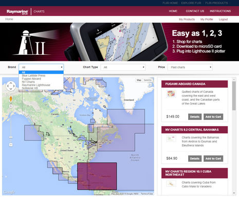
I heard in Miami that the online Raymarine Chart Store would soon open, but I had no idea how well stocked the virtual shelves would be. It was great when Ray enabled its own Lighthouse raster and vector chart format a year ago even though they only duplicated NOAA’s entire free coverage of US coastal waters. Now there are more free charts available — for other nations that also give their data away, like Brazil and New Zealand — as well as access to an interesting array of commercial charts…
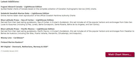
North American Raymarine users will especially notice more raster chart choices with Fugawi Aboard for Canada, Blue Latitude Press for western Mexico, and lots of NV Charts Caribbean coverage. However, official charts for Sweden and Finland are already available, and I gather that much more coverage is coming. And mind you, all this is in addition to the full Navionics support which has alway been built into the Raymarine a-, c-, e- and gS Series (Dragonfly, too), and which now includes SonarCharts and easy MFD chart updating via Navionics app (sonar log uploading, too), not to mention Platinum+ extras. And the full Jeppesen C-Map support that became a reality in February, which includes 4D Max+ with its own full raster layer and sat photo maps. I don’t know if Navionics or C-Map will become available in the Chart Store as well as on preprogrammed SD cards, but overall, this is terrific news for those who like chart choices, and note that Raymarine pulled it all off in about one year!
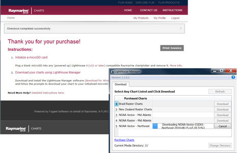
Note, though, that selling commercial charts online is more complicated than just giving away the Lighthouse version of uncopyrighted NOAA charts. I had to re-register myself to even download the free charts, and I was lucky that I had a microSD card that had already been initialized by being put into a Raymarine MFD running LightHouse v11 or later (since my test Ray plotters are 1,000 miles away). I also had to install a new LightHouse Manager utility program that does the actual work of downloading the charts to the SD card — it’s available for Windows 7 or 8, or Mac OSX — and I was still never able to successfully download the Mid Atlantic Vector region seen in the list above. Everything else worked fine though, which seems pretty good for a brand new online Raymarine Chart Store. Then again, note the subtly-fonted credit at the bottom of the store pages that reads, “Powered by Fugawi Software on behalf of Raymarine…”
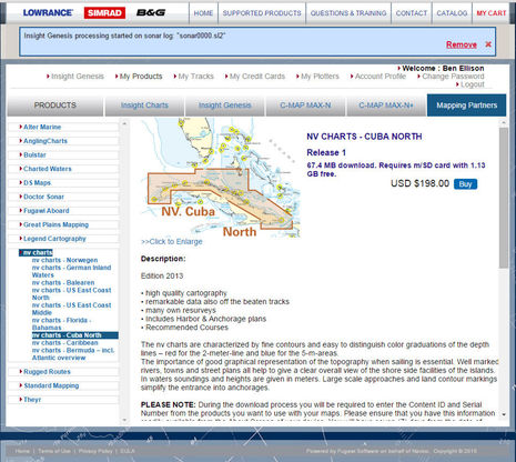
In fact, Fugawi seems to be the quiet Canadian hero behind a lot of chart stores. Note the same “Powered by…” credit at Navico’s Insight Store (soon to be relaunched as the GoFree Shop) and also consider the X-Traverse online store that’s been serving charts to various tablet and PC charting apps since at least 2010. Fugawi seems to have developed a serious talent for managing online chart distribution while dealing with numerous competing chart sources and plotter developers. It’s interesting to see how they custom tailored the Navico and Raymarine stores, but there are also many distinct similarities, like the availability of those NV Charts for Cuba seen above. I’ve heard that they are the best available for that interesting island that may soon be open to U.S. cruisers (lots on the changing Cuba situation at Passagemaker).
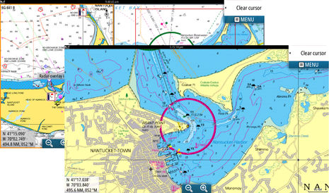
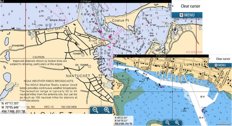
I haven’t yet seen the new commercial LightHouse charts running on Raymarine screens, but I have had a little experience with Fugawi and NV raster charts on the Simrad NSS16 and 7 evo2 MFDs currently on Gizmo. In the background of the collage above you can see the NV Chart for Nantucket displaying side by side with the Navionics equivalent, and in the foreground you can see in greater detail NV’s unique raster presentation (which is also still available in print and via app). The collage below shows Fugawi’s copy of the regular NOAA raster chart for Nantucket and also its CHS raster for Lunenberg, Nova Scotia (a port I’d particularly like to visit as that’s where the great Covey Island Boatworks finished out Gizmo).
I remember back in 2005 when the only Canadian raster chart choice was to rent the PC-only NDI version at considerable cost and hassle. And while MapMedia has for a while offered Canadian rasters that run on various TimeZero platforms like Furuno NavNet 3D, all of a sudden Raymarine has them in two forms — Fugawi and C-Map 4D Max+ — and so will Navico once the 2015 version of C-Map Max-N+ rolls out (it already has with Lowrance Gen2 V4, and the Release Notes there have the best detail on the N+). Meanwhile, Navico is first to make a lot of this chart goodness directly downloadable to an MFD over WiFi, but I sense that Furuno and Raymarine have similar intentions.
Overall, it’s amazing how fast this MFD chart choice thing is developing, and while that’s great, I hope that the Garmin users disgruntled about the Navionics SonarChart mess pay particular attention to how fast and surprising these changes have been. I have no idea what Garmin is up to regarding chart choices, but maybe a little patience is in order?


I’ll be darned! There’s yet another chart store “Powered by Fugawi…”
https://chartselect.humminbird.com/
In fact, Humminbird has also made great strides in the area of chart choices. The latest ION and ONIX MFDs support Navionics, C-Map and Humminbird’s own charts:
http://www.humminbird.com/Category/Technology/TriFuel/
They also support easy chart making…
http://www.humminbird.com/Category/Technology/Autochart/
…and even live sonar chart making on an MFD, a first I believe…
http://www.humminbird.com/Category/Technology/AutoChart-Live/
…though I believe the data is only sharable with friends, not the whole world of Humminbird users or beyond.
Am I the only one who runs in “course-up” mode, rather than “north-up”
Raster charts are pretty aggravating in that mode, unless you like the challenge of reading upside-down.
NOAA vector charts for my area seem to be in the very distant future.
Good point, Karl, and not obvious as my screenshots are all North Up. However, let me add a few points:
* Most everyone does planning in North Up mode. Course or Head up (and 3D) are only useful when underway.
* Most MFDs these days will let you have one chart (possibly raster) North Up in one window and a different chart (possibly vector) Head Up in another window.
* Reading Head Up raster charts only gets truly tricky when you’re headed in a southerly direction and a lot of the data is graphic anyway, not textual.
PS I’m surprised there aren’t NOAA ENC’s for your area. I thought that they’d pretty much finished converting the whole portfolio. Where the heck are you, Karl?
Autochart is probably a rehash o the DrDepth software that they bought up a year or so ago.
Ben-
I boat only on Lake Champlain and Lake Ontario (well, Canadian waters, too).
Last time I checked, NOAA ENCs were only available for
ocean coastline and none of the Great Lakes.
Look again, Karl. Champlain and Ontario both seem to be covered at the same scales in NOAA raster and vector:
http://www.charts.noaa.gov/InteractiveCatalog/nrnc.shtml
However, it doesn’t look like they’ve converted the NY Canal System chartbook to ENC yet.
******************
Tim, “rehash” seems a bit unfair. I’ll bet the interface with Humminbird is smoother than when DrDepth was independent, and of course DrDepth could never have made AutoChart-Live happen on its own. The companies that make the chart and sonar displays are in a very powerful position and, incidentally, less beholden to any one chart maker once they support multiple makers (as described in this entry).
Digital Yacht just added $30 Canadian vector chart coverage to its $30 iOS app that already includes U.S. vectors. When it rains, it pours!
http://digitalyacht.net/2015/03/18/navlink-ios-app-gets-canada-charts/
This is why I chose to upgrade to Raymarine rather than Garmin. But one question: You do need to download the charts onto a microSD card previously installed in the chartplotter, which writes an encoded file on it. The question is, previously installed in “A” chart plotter, or “THE” chartplotter?
I know that it will share the data across the network so that the data on an installed card can be used on any chartplotter. However there are times (due to equipment failure or power conservation typically) when one chartplotter may be shut down. Can I take the microSD card initialized on my E95, download a chart to it, then use it on my e125 with the e95 shut down?
I guess I should ask this of Raymarine, but it is of general interest. On my trip out to the Bahamas last year, one plotter (E120) failed within an hour out of Norfolk, if my charts had been node-locked to that plotter, now out of range of WiFi etc, I would have been in a pickle. Instead I just moved the cartridge to the other plotter (E80) and kept going. I don’t mind loading the charts on two separate microSD cards as insurance either, but I don’t know if the Chart Store allows that.
Yeah I would just try this but my boat is 1500 miles away.
Good question, Anomaly, and here’s a pleasing answer from Raymarine:
“Happy to report that once the charts are successfully downloaded to the microSD they can be uses in ANY Raymarine display with software v11 or later. Some helpful Instructions can be found here: https://charts.raymarine.com/downloads Be sure to mouse over the More info for each topic.
In short, the cartography is encrypted to an “initialized” microSD. You may initialized any microSD on ANY plotter running v11 or later. Initialization simply writes a Lighthouse ID file to the card that is used in the encryption process.”
I bought an A series Raymarine MFD because of the new Lighthouse software and the free NOAA charts which were supposed to be updated quarterly. The chartplotter is great but the charts haven’t been updated since last August. And their chart store as stated previously is ” powered by Fugawai”
When I asked Raymarine about the updates they said it is still their intention to update quarterly. Maybe not enough people have brought this to their attention to make it a priority.
Navico’s new GoFree Shop — replacing the Insight Store, and also “powered by Fugawi” — is now up and looking good:
https://www.gofreeshop.com/
Al, I too was disappointed that latest LightHouse NOAA charts are dated August, 2014, but am hopeful that they’ll get on a more frequent update schedule now that the transition to the Chart Store is done. Also, even yearly is pretty good for free (note that Navico only sells the NOAA rasters bundled with FugawiAboard Canadian charts).
The Raymarine Chart Store just announced chart updates and Ray now seems committed to quarterly updates. They are no longer free, however. But $9.99 for a year subscription, i.e. 4 updates, seems quite fair. Raster and ENC are separate subscriptions, but the $9.99 will cover the whole East or West Coast if that’s what you need.
https://charts.raymarine.com/
I bought a second A65 under the premise that charts would be free and I get an email from Raymarine that an update was available and oh by the way it is no longer free. I can download these same charts from NOAA for free and use them on Coastal Explorer. Why are a couple of countries still free but no the US? I agree it is a good value with 4 updates included but it should be spelled out ahead of time and maybe “grandfathered” in.
While $10 isn’t much, it is a lot more than free which is what was advertised when I bought the chartplotter(s). I wonder how the price will change with time. The only processing they do on these is to convert them to their proprietary format, which is for their convenience, not mine. They are quilted, but laptop programs like PolarView also quilt them just as well or better, with charts and updates free and no data processing.
It’s a good news day. Raymarine just announced lots more NV Charts coverage (raster style) for Europe and the Caribbean:
http://www2.raymarine.eu/webmail/7392/527136657/7b2dbe60e491ed4ca89416af65e96945
And because I already have an account set up at Ray’s Lighthouse Chart Store, it just took a few minutes to download the new NV demo charts to check out on Gizmo.
Marine charting world seems to be in play! Yesterday Johnson Outdoors (Humminbird) acquired much of Northport Systems (Fugawi):
http://investor.johnsonoutdoors.com/releasedetail.cfm?ReleaseID=963649